
The Northern Mariana Islands, officially the Commonwealth of the Northern Mariana Islands, is an unincorporated territory and commonwealth of the United States consisting of 14 islands in the northwestern Pacific Ocean. The CNMI includes the 14 northernmost islands in the Mariana Archipelago; the southernmost island, Guam, is a separate U.S. territory. The Northern Mariana Islands were listed by the United Nations as a non-self governing territory until 1990. The Northern Marianas were part of U.N. Trust after WW2, previously they had been under control the Spanish (1500s-1899), German (1899-1914), and Japanese (1914-1944); in the late 20th century they eventually settled on joining the United States. This process was completed in the late 20th century and recognized internationally, and the people of the Northern Marianas became United States citizens by their choice in 1986. They have one Federal representative in Congress. The other U.S. Pacific territories are Guam, American Samoa, and the State of Hawaii. The population of the Northern Mariana's is several times smaller than the a U.S. State so its representation is handled differently. The Northern Marianas are near to but separate from the U.S. Commonwealth of Guam which became a part of the USA since 1898. Together Guam, CNMI, American Samoa, and Hawaii represent Pacific peoples of the United States tying together many of assets such as marine reserves, atolls, and islands dotting the Pacific.

Saipan is the largest island and capital of the Northern Mariana Islands, a commonwealth of the United States in the western Pacific Ocean. According to 2020 estimates by the United States Census Bureau, the population of Saipan was 43,385, a decline of 10% from its 2010 count of 48,220.

Garapan is the largest village and the center of the tourism industry on the island of Saipan, which is a part of the United States Commonwealth of the Northern Mariana Islands (CNMI). Garapan, as a census-designated place, has an area of 1.2 km2 (0.46 sq mi) and a population of 3,588.

The following is an alphabetical list of articles related to the Commonwealth of the Northern Mariana Islands.

Landing Beaches; Aslito/Isely Field & Marpi Point, Saipan Island is a National Historic Landmark District consists of several discontiguous areas of the island of Saipan in the Northern Mariana Islands. The sites were designated for their association with the Japanese defense of Saipan during World War II, the 1944 Battle of Saipan in which United States forces captured the island, and the subsequent campaigns which used Saipan as a base. The district includes the landing beaches where the U.S. forces landed, the remnants of Japanese airfields Aslito and Marpi Point and Isely Field, the airfield built over much of Aslito from which B-29 bombers were used to bomb the Japanese home islands. The Marpi Point area includes Suicide Cliff and Banzai Cliff, two locations where significant numbers of Japanese military and civilians jumped to their deaths rather than surrender to advancing U.S. forces. The loss of Saipan was a major blow to the Japanese war effort, leading to the resignation of Prime Minister Hideki Tojo, The landmark designation was made in 1985.
Japanese Lighthouse may refer to:
The Maritime Heritage Trail – Battle of Saipan is located within the protected waters of Saipan lagoon in the Northern Marianas archipelago. The majority of the dive sites including two Japanese shipwrecks, two Japanese aircraft, two US aircraft, a US landing vehicle and two Japanese landing craft can be found in the clear waters between Garapan, Tanapag Harbor, and Mañagaha Island while further south in Chalan Kanoa Lagoon there are three US tanks.
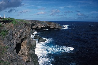
Banzai Cliff is a historical site at the northern tip of Saipan island in the Northern Mariana Islands, overlooking the Pacific Ocean. Towards the end of the Battle of Saipan in 1944, hundreds of Japanese civilians and soldiers jumped off the cliff to their deaths in the ocean and rocks below, to avoid being captured by the Americans. Not far away, a high cliff named Suicide Cliff overlooks the coastal plain, and was another site of numerous suicides. At Banzai Cliff, some who jumped did not die and were captured by American ships.
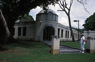
The Japanese Hospital or Saipan Byoin is a historic World War II-era hospital complex on Route 3 in Garapan, a village on the island of Saipan in the Northern Mariana Islands. The three concrete buildings are the largest Japanese-built structures to survive the war. The main hospital building is an L-shaped structure with a domed entrance at the crook of the L. A second, smaller building housed the pharmacy, while the third is an underground circular chamber of unknown purpose. All were in deteriorating condition when surveyed in the early 1970s. The complex has since undergone restoration, and the main hospital building now houses the Northern Mariana Islands Museum.

The Japanese Jail Historic and Archeological District in Garapan (Saipan), MP, is a historic district that was listed on the U.S. National Register of Historic Places in 2011. The listing included two contributing structures and 15 contributing sites. It includes ruins of a jail that was built in 1930 and was used until 1944.
The Japanese Lighthouse, or Poluwat Lighthouse, is an abandoned lighthouse situated on Alet Island in Poluwat, Chuuk in the Federated States of Micronesia. It was completed in 1940 by the Japanese and was in use until being attacked by U.S. forces in World War II. It was listed on the National Register of Historic Places in 1983. The lighthouse is a good example of pre-World War II "marine architecture" built by the Japanese.

The Campaneyan Kriso Rai, also known as the Catholic Belltower, is a historic church tower in Garapan, the largest village on Saipan island in the Northern Mariana Islands. Built in 1932, it is the only element of the island's most prominent Roman Catholic church to survive bombardment in World War II. The tower, a concrete structure 3 meters (9.8 ft) square and 10 meters (33 ft) tall, was built by Spanish Jesuits brought in by the Japanese South Seas Mandate administration, and stood next to an 1860 wood-frame church.

The Japanese 20mm Cannon Blockhouse is one of many relics of World War II on the island of Saipan in the Northern Mariana Islands. It is a concrete blockhouse, semi-circular in shape with a diameter of about 6 metres (20 ft). Its walls are 1.22 metres (4.0 ft) thick with four firing ports large enough to accommodate 20mm cannons, originally equipped with steel sliding shutters. A steel door 25 millimetres (0.98 in) thick provides access to the structure at the rear, sheltered by a concrete wall and covered defensively by a machine gun port. The blockhouse is located near the center of what is locally called Big Agingan Beach, on the south coast of the island, about 20 metres (66 ft) from the shore. It was built in some haste by the Japanese forces defending Saipan in 1944, and was captured by Allied forces early in the Battle of Saipan.
The Nan'yō Kōhatsu Kabushiki Kaisha complex was the main support base of the Nan'yō Kōhatsu Kabushiki Kaisha (NKKK) on the island Tinian in the Northern Mariana Islands. The NKKK was an economic development company established by the Empire of Japan to develop the territories of the South Seas Mandate, which it oversaw between the First and Second World Wars. In the Northern Marianas, the company aggressively developed arable areas for sugar cane farming, importing workers from Japan, Okinawa, and Korea. Each of the three major islands had major support facility. On Tinian, this area, now roughly where the island's largest community, San Jose is located on the south coast, consisted of an extensive development, most of which was destroyed during the Battle of Tinian in the Second World War. Of this large complex, only four buildings or structures remain, all of which have been listed on the United States National Register of Historic Places, as rare surviving examples of pre-war Japanese architecture on the islands.
The Unai Lagua Japanese Defense Pillbox is one of the more unusual surviving World War II-era Japanese fortifications on the island of Saipan in the Northern Mariana Islands. It is located at the southern end of Unai Lagua, which stretches along the northern shore of the island. The pillbox is fashioned out of poured concrete and coral boulders, and uses natural rock formations as part of its walls. This construction was necessitated by a severe shortage of building materials on the island as the Japanese prepared the island's defenses against the advancing Allied forces in 1943–44. The use of natural materials and terrain had the added benefit of rendering the position nearly invisible to aerial or offshore observation.
The NMI Museum of History and Culture, also known as the NMI Museum, is a museum in Garapan, Saipan hosting exhibitions about the Chamorro and Carolinian people and also displays artifacts, documents, textiles, and photographs from the Spanish, German, Japanese, and American periods in the Northern Mariana Islands. The museum has repatriated a significant number of historic objects from the Marianas that were held nationally and internationally in private collections and by foreign museums, companies, and militaries. More than one million dollars has been invested in its collections. The historical buildings on the grounds have been renovated to preserve them, prevent further deterioration, and safeguard visitors. The museum is located across from Sugar King Park.
The Garapan Heritage Trail is located in Garapan, Saipan, Northern Mariana Islands. The cultural heritage trail project is supported through grants awarded to the Northern Marianas Humanities Council by the National Endowment for the Humanities and the Office of Insular Affairs, United States Department of the Interior.

Sugar King Park is a municipal park located in Garapan, Saipan, Northern Mariana Islands across from the NMI Museum of History and Culture. The park was named in honor of the "Sugar King" Haruji Matsue, director of the South Seas Development Company.

The Saipan Katori Shrine is a Shintō shrine in Sugar King Park, Garapan, Saipan. The main festival of the shrine is held annually in October. Ceremonies are conducted by the Japanese Society of Northern Marianas and presided over by priests of the Katori Shrine in Chiba Prefecture, Japan. The shrine is a place of prayer for peace and prosperity. It is listed on the Garapan Heritage Trail, a project of the Northern Marianas Humanities Council with financial support by the National Endowment for the Humanities and the Office of Insular Affairs, United States Department of the Interior.
The 2022 Northern Mariana gubernatorial election took place on November 8, 2022 to elect the governor of the Northern Mariana Islands and the lieutenant governor of the Northern Mariana Islands to a four-year term in office. Because no candidate received 50% of the vote in the general election, the two highest-placing candidates advanced to a runoff election on November 25, 2022.


