Related Research Articles

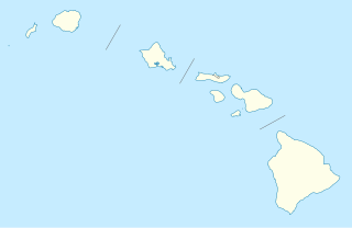
The Northern Mariana Islands, officially the Commonwealth of the Northern Mariana Islands, is an unincorporated territory and commonwealth of the United States consisting of 14 islands in the northwestern Pacific Ocean. The CNMI includes the 14 northernmost islands in the Mariana Archipelago; the southernmost island, Guam, is a separate U.S. territory. The CNMI and Guam are the westernmost territories of the United States.

Mañagaha is a small islet which lies off the west coast of Saipan within its lagoon in the Northern Mariana Islands. Although it has no permanent residents, Mañagaha is popular among Saipan's tourists as a day-trip destination due to its wide sandy beaches and a number of marine activities including snorkeling, parasailing and jet skiing.
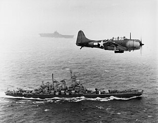
The Gilbert and Marshall Islands campaign were a series of battles fought from November 1943 through February 1944, in the Pacific theatre of World War II between the United States and Japan. They were the first steps of the drive across the central Pacific by the United States Pacific Fleet and Marine Corps. The purpose was to establish airfields and naval bases that would allow air and naval support for upcoming operations across the Central Pacific. Operation Galvanic and Operation Kourbash were the code names for the Gilberts campaign that included the seizures of Tarawa and Makin, during the Battle of Tarawa of 20-23 November and the Battle of Makin of 20–24 November 1943. Operation Flintlock and Operation Catchpole were aimed at capturing Japanese bases at Kwajalein, Eniwetok, and Majuro in the Marshall Islands.

The Sitka Naval Operating Base and U.S. Army Coastal Defenses are the surviving elements of the World War II-era defenses and defense establishments in and around Sitka, Alaska. These facilities, in particular the airfields and naval bases, played a key role in the defense of Alaska, and in military operations against Japanese forces which occupied Attu and Kiska, two remote islands in the Aleutian chain. The Sitka facilities were designated a National Historic Landmark in 1986.

The Dutch Harbor Naval Operating Base and Fort Mears were the two military installations built next to each other in Dutch Harbor, on Amaknak Island of the Aleutian Islands in Alaska, by the United States in response to the growing war threat with Imperial Japan during World War II. In 1938, the Navy Board recommended the construction which began in July 1940. The first United States Army troops arrived in June 1941 and an air base constructed by the United States Navy was finished in September 1941. At the time of the surprise attack on Pearl Harbor, these were the only military installations in the Aleutian Islands.

Landing Beaches; Aslito/Isely Field & Marpi Point, Saipan Island is a National Historic Landmark District consisting of several discontiguous areas of the island of Saipan in the Northern Mariana Islands. The sites were designated for their association with the Japanese defense of Saipan during World War II, the 1944 Battle of Saipan in which Allied forces captured the island, and the subsequent campaigns which used Saipan as a base. The district includes the landing beaches where the Allies landed, the remnants of Japanese airfields Aslito and Marpi Point, and Isely Field, the Allied airfield built over much of Aslito from which B-29 bombers were used to bomb the Japanese home islands. Included in the Marpi Point area are Suicide Cliff and Banzai Cliff, two locations where significant numbers of Japanese military and civilians jumped to their deaths rather than surrender to advancing forces. The loss of Saipan was a major blow to the Japanese war effort, leading to the resignation of Prime Minister Hideki Tojo, The landmark designation was made in 1985.
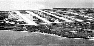
North Field is a former World War II airfield on Tinian in the Mariana Islands. Abandoned after the war, today North Field is a tourist attraction. Along with several adjacent beaches on which Allied forces landed during the Battle of Tinian, the airfield is the major component of the National Historic Landmark District Tinian Landing Beaches, Ushi Point Field, Tinian Island.
Naval Station Pearl Harbor is a United States naval base adjacent to Honolulu, in the U.S. state of Hawaii. In 2010, along with the United States Air Force's Hickam Air Force Base, the facility was merged to form Joint Base Pearl Harbor–Hickam.

The Japanese Lighthouse is an abandoned lighthouse situated atop Navy Hill in Garapan, Saipan, in the Northern Mariana Islands. It was listed on the National Register of Historic Places in 1974. The lighthouse is one of the few surviving pre-World War II, civilian structures built by the Japanese.
Suicide Cliff is a cliff above Marpi Point Field near the northern tip of Saipan, Northern Mariana Islands, which achieved historic significance late in World War II.
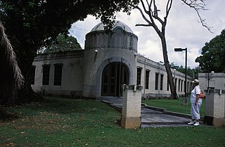
The Japanese Hospital or Saipan Byoin is a historic World War II-era hospital complex on Route 3 in Garapan, a village on the island of Saipan in the Northern Mariana Islands. The three concrete buildings are the largest Japanese-built structures to survive the war. The main hospital building is an L-shaped structure with a domed entrance at the crook of the L. A second, smaller building housed the pharmacy, while the third is an underground circular chamber of unknown purpose. All were in deteriorating condition when surveyed in the early 1970s. The complex has since undergone restoration, and the main hospital building now houses the Northern Mariana Islands Museum.
The Japanese Lighthouse, or Poluwat Lighthouse, is an abandoned lighthouse situated on Alet Island in Poluwat, Chuuk in the Federated States of Micronesia. It was completed in 1940 by the Japanese and was in use until being attacked by U.S. forces in World War II. It was listed on the National Register of Historic Places in 1983. The lighthouse is a good example of pre-World War II "marine architecture" built by the Japanese.

The Commissioner's Office is a rare surviving example of transitional Spanish-Japanese architecture on the island of Rota in the Northern Mariana Islands, an insular area of the United States in the western Pacific Ocean. It is a single-story structure with walls of manposteria, a construction method adopted during the Spanish period. The window trim consists of ifil lintels, and the building's cornice is Japanese in style. At the time of the building's listing on the National Register of Historic Places in 1981, it was in deteriorated condition, lacking a roof and with one collapsed wall. The structure was built in the 1930s by the local Chamorro people, who had been displaced to that part of the island by Japanese settlement undertaken as part of the South Seas Mandate. The building housed the offices of a local commissioner, or village head responsible to the Japanese authorities. Many buildings built by the Japanese during the mandate period were destroyed in World War II.
The Hachiman Jinja is a derelict Shinto shrine off Kagman Road on the island Saipan in the Northern Mariana Islands, and one of the few on those islands to survive relatively intact. The shrine, dedicated to the kami Hachiman, was probably built in the 1930s by the Japanese administration of the South Seas Mandate as part of a program to Japanize the large number of Ryukyuan and Korean workers on the island. The shrine survived the World War II Battle of Saipan in remarkably good condition, although its main torii fell, and two komainu were lost. The main honden received some maintenance in the 1970s, and the property has received some maintenance from a local landholder. As of 2019, it is in total disrepair.

The Japanese 20mm Cannon Blockhouse is one of many relics of World War II on the island of Saipan in the Northern Mariana Islands. It is a concrete blockhouse, semi-circular in shape with a diameter of about 6 metres (20 ft). Its walls are 1.22 metres (4.0 ft) thick with four firing ports large enough to accommodate 20mm cannons, originally equipped with steel sliding shutters. A steel door 25 millimetres (0.98 in) thick provides access to the structure at the rear, sheltered by a concrete wall and covered defensively by a machine gun port. The blockhouse is located near the center of what is locally called Big Agingan Beach, on the south coast of the island, about 20 metres (66 ft) from the shore. It was built in some haste by the Japanese forces defending Saipan in 1944, and was captured by Allied forces early in the Battle of Saipan.
The former Japanese Hospital building on the island of Rota in the Northern Mariana Islands is one of the few remaining Japanese-era buildings on the island. It is a single-story L-shaped concrete structure. When listed on the National Register of Historic Places in 1981, it was described as being in derelict condition, being little more than the concrete structure, lacking a roof, windows, and most of its woodwork. The window openings are sheltered by typical Japanese concrete canopies. The building was built by the Japanese about 1930, during the South Seas Mandate period; most Japanese-built structures on Rota were destroyed during World War II.
The Nan'yō Kōhatsu Kabushiki Kaisha complex was the main support base of the Nan'yō Kōhatsu Kabushiki Kaisha (NKKK) on the island Tinian in the Northern Mariana Islands. The NKKK was an economic development company established by the Empire of Japan to develop the territories of the South Seas Mandate, which it oversaw between the First and Second World Wars. In the Northern Marianas, the company aggressively developed arable areas for sugar cane farming, importing workers from Japan, Okinawa, and Korea. Each of the three major islands had major support facility. On Tinian, this area, now roughly where the island's largest community, San Jose is located on the south coast, consisted of an extensive development, most of which was destroyed during the Battle of Tinian in the Second World War. Of this large complex, only four buildings or structures remain, all of which have been listed on the United States National Register of Historic Places, as rare surviving examples of pre-war Japanese architecture on the islands.
The Unai Lagua Japanese Defense Pillbox is one of the more unusual surviving World War II-era Japanese fortifications on the island of Saipan in the Northern Mariana Islands. It is located at the southern end of Unai Lagua, which stretches along the northern shore of the island. The pillbox is fashioned out of poured concrete and coral boulders, and uses natural rock formations as part of its walls. This construction was necessitated by a severe shortage of building materials on the island as the Japanese prepared the island's defenses against the advancing Allied forces in 1943–44. The use of natural materials and terrain had the added benefit of rendering the position nearly invisible to aerial or offshore observation.
The Unai Obyan Latte Site is a prehistoric archaeological site on the island of Saipan in the Northern Mariana Islands. Located near Obyan Beach on the south coast of the island, it is the site of what was once a fairly extensive village, which was significantly disturbed by Japanese defensive preparations during World War II. The site includes the fragmentary remains of a single latte stone house site and a wide scattering of surface-level remains. Excavation of the latte house site in the 1940s by the pioneering archeologist Alexander Spoehr yielded evidence of a length period of occupation. The village at Obyan was documented in early Spanish accounts of the island, and was probably abandoned when the Spanish forcibly relocated the entire island population to Guam in 1698.

The Nan'yō Kōhatsu Kabushiki Kaisha Sugar Mill is a former industrial facility in the village of Songsong on the island of Rota in the Northern Mariana Islands. Its ruins are a significant reminder of the South Seas Mandate period, when Imperial Japan engaged in large-scale sugar cane farming in the Northern Marianas, and are the only brick structure in the Northern Marianas. The sugar mill on Rota was one of the major installations of the Nan'yō Kōhatsu Kabushiki Kaisha, the Japanese company responsible for economic development of the mandate area. Its Executive Director turned Board Chairman. Haruji Matsue, considered the Northern Mariana Islands, the best place to establish the sugar industry, and more especially since previous Japanese commercial enterprises tried their hand at growing and processing sugar cane, but failed. The Nan'yō Kōhatsu Kabushiki Kaisha, was the most dominant economic force and being the largest Japanese Corporation, came to the Northern Marianas in 1921. Not unlike its predecessors, the NKK experienced a very tough few years, which almost forced the company to cease operations. Things started to take a turn for the better in 1926. By the early 1930's, Matsue proceeded to expand the company's landholdings and operations to Tinian and Rota, respectively. Rota had one mill and 38% of the farmlands had sugar cane growing. The remnants of this sugar mill, all that survived the Allied capture of Rota during World War II, are located on the north side of the peninsula that projects southwest from Songsong, and consist of fragments of brick and concrete structures. The most impressive single element is a brick and concrete tunnel 42.5 metres (139 ft) long, from which openings lead to the locations of other parts of the once-extensive complex.
References
- 1 2 "National Register Information System". National Register of Historic Places . National Park Service. July 9, 2010.
- ↑ "NRHP nomination for Chudang Palii Japanese World War II Defensive Complex". Academia.edu. Retrieved 2015-04-13.
| Topics | |
|---|---|
| Lists by state |
|
| Lists by insular areas | |
| Lists by associated state | |
| Other areas | |
| Related | |
| | This article about a property in the Northern Mariana Islands on the National Register of Historic Places is a stub. You can help Wikipedia by expanding it. |