Mount Washington (Oregon)

Last updated

Mount Washington
Mount Washington, OR, USFS.jpg
Mount Washington as seen from Big Lake on the northwest
Highest point
Elevation 7,795 ft (2,376 m) [1] [2]
Prominence 2,554 ft (778 m)  OOjs UI icon edit-ltr-progressive.svg
Coordinates 44°19′56″N121°50′19″W / 44.3321254°N 121.8385292°W / 44.3321254; -121.8385292 [3]
Geography
Usa edcp relief location map.png
Red triangle with thick white border.svg
Mount Washington
Parent range Cascade Range
Topo map USGS Mount Washington
Geology
Age of rock Pleistocene
Mountain type Shield volcano, [1] stratovolcano, [4] volcanic plug
Volcanic arc Cascade Volcanic Arc
Last eruption >250,000 years ago (estimated) [5] [6]
Climbing
First ascent 1923 by E. McNeal and party [7]

Mount Washington is a deeply eroded volcano in the Cascade Range of Oregon. It lies within Deschutes and Linn counties and is surrounded by the Mount Washington Wilderness area.

Contents

Like the rest of the Oregon Cascades, Mount Washington was produced by the subduction of the oceanic Juan de Fuca tectonic plate under the continental North American tectonic plate, forming during the late Pleistocene. Made mostly of mafic (rich in magnesium and iron) volcanic rock like subalkaline basalt and basaltic andesite, it has a volcanic plug occupying its summit cone and numerous dikes. It is surrounded by other volcanic features such as cinder cones and spatter cones. The volcano's last eruptions took place from spatter cones about 1,350 years ago, generating basaltic andesite lava deposits.

Mount Washington has barren surroundings, which have seen little historical recreational use. A wagon road at McKenzie Pass was built in 1872, which was later paved during the 1930s. On August 26, 1923, the mountain was first ascended by six boys from the neighboring city of Bend. The surrounding area was designated the Mount Washington Wilderness by the federal government in 1964. The wilderness area is not heavily used, though it has a number of hiking trails. Wildlife is sparse in the region. Vegetation is mostly limited to pines and shrubs. Animal life includes deer, American black bear, cougar, various small animal species, and some fish species in the lakes.

Geography

With an elevation of 7,795 feet (2,376 m) above sea level, [1] [2] Mount Washington is located in Deschutes and Linn counties in the U.S. state of Oregon. [8] It lies north of McKenzie Pass, [3] and some 12 miles (19 km) west of the city of Sisters. [9] It is accessible by foot trails only; the western and southwestern sides of Washington intersect with the Skyline Trail about 3.1 miles (5 km) from the Big Lake trailhead near U.S. Route 20. [10]

Despite being one of the smaller volcanic peaks in the Oregon Cascades, [11] Mount Washington is the most prominent landmark between North Sister and Three Fingered Jack, with the Cache Mountain cinder cones to the northeast and Hayrick Butte and Hoodoo Butte to the northwest. [12] The volcano forms a crest of steep, icy mountains with North Cinder Peak and Three Fingered Jack to the south of Mount Jefferson. [13] The volcano has a pinnacle appearance resembling the spire-like shape of Mount Thielsen. [14] According to Harris (2005), the volcano resembles Cleopatra's Needle from certain angles and the Sugarloaf Mountain in Brazil from others. [5] The proximal relief for the volcano is 2,707 feet (825 m), while the draping relief is 3,363 feet (1,025 m). [a] The volcano has an overall volume of 3.6 cubic miles (15 km3). [2]

Physical geography

Elevations in the Mount Washington area range from 3,200 feet (980 m) to greater than 7,700 feet (2,300 m). [15] Most precipitation falls during the winter as snow, and summers are warm and dry. [7] During the winter season, the Cascades are covered with thick snow. As a result, Oregon Route 242 over McKenzie Pass becomes impassable from fall through late spring, while the Santiam Highway and Oregon Route 126 are maintained and remain open. [11]

Within the Mount Washington Wilderness, there are outwash plains and lateral, recessional, and terminal ground moraines. Many of these glacial deposits were created during the most recent glacial advance in the late Pleistocene, though there are Holocene glacial deposits as well. [16] There was an ice sheet during the late Pleistocene between Mount Washington and Three Fingered Jack. [17] The McKenzie River, fed by Clear Lake, runs south for about 15 miles (24 km) just west of Mount Washington before it turns west for another 70 miles (110 km) and meets the Willamette River near the city of Eugene. [18]

Wilderness

The Mount Washington Wilderness covers an area of 54,278 acres (219.66 km2). [19] First named a wild area by the United States Forest Service in 1975, it was designated as one of the original wilderness areas under the 1964 Wilderness Act. [7] Located 32 miles (51 km) to the west of Bend, the Mount Washington plot is the smallest of three wilderness areas that encompass most of the High Cascades, a physiographic region located in the central part of Oregon; [9] the two others are the Three Sisters Wilderness and Mount Jefferson Wilderness. [20] Used mostly by hunters, hikers, and climbers, [19] the Mount Washington area includes the Dee Wright Observatory, smaller volcanoes, and parts of the Pacific Crest Trail, [9] which runs north–south through the wilderness [9] for about 16.6 miles (26.7 km). [19] Other major features include Belknap Crater and 28 lakes. [19] The wilderness area is jointly administered by authorities for the Willamette National Forest and Deschutes National Forest. [15]

Mineral and geothermal potential

A mineral survey from 1980 through 1981 detected little potential for metallic mineral or fossil fuel resources in the Mount Washington Wilderness. [9] The area contains large amounts of cinder – more than 200,000,000 cubic yards (0.15 km3) [21] [22] – but there are alternate sources in the region, which are sufficient to meet local demands. Likewise, there are no mines in the area, [21] nor any documented history of mining claims; [23] the closest mines are located 20 miles (32 km) to the west in the Blue River mining district. [23] The volcanic vents throughout the Mount Washington Wilderness are underlain by Eocene to Pliocene volcanic rock layers, which do not contain hydrocarbons for fossil fuels. [24] While there is relatively little potential for geothermal energy in the High Cascades, there are hot springs along the western edge of the mountain range. [25] The Belknap Hot Spring lies 4 miles (6.4 km) to the southwest of the wilderness area, ejecting water at a rate of 75 U.S. gallons (280 L) per minute with a temperature of 180 °F (82 °C). [24]

Ecology

Described by Wuerthner (2003) as a "rocks and ice wilderness," [15] much of the Mount Washington Wilderness consists of lava flows and rubble. However, it does include some forested areas, as well as 28 lakes in the northern and southwestern parts of the space. [15] Vegetation in the area includes mountain hemlock, [19] lodgepole pine, ponderosa pine, and whitebark pine. [15] Ponderosa pine occurs at the eastern base of the volcano, with Douglas fir on the western side. [7] Vegetation is sparse on lava-covered surfaces. [24] Mountain hemlock, however, also grows on lava flows, and there is an understory of beargrass, huckleberry, and rhododendron. [7] Animal life includes large animals such as deer and elk, with the rare American black bear or cougar. Smaller animals like pikas, marmots, martens, snowshoe hares, and ground squirrels are also found in the area. [7] Lakes in the wilderness sustain populations of brook trout, cutthroat trout, and rainbow trout, and frogs can be observed around some of them. [26]

Human history

The barrenness of Mount Washington's surroundings means that it has seen little historical recreational use. A wagon road at McKenzie Pass was built in 1872, which was later paved during the 1930s and became Oregon Route 242. It received its name from the nearby McKenzie River, which in turn derived its name from Donald McKenzie, a fur trader who explored the area in 1812. On August 26, 1923, [27] Mount Washington was climbed for the first time by six boys from Bend: [7] Ervin McNeal, Phil Philbrook, Armin Furrer, Wilbur Watkins, Leo Harryman, and Ronald Sellars. [27]

Before Mount Washington's surroundings were designated a wilderness area in 1964, [7] the Willamette National Forest administration had planned to open them to commercial timber production to address a shortage in Lane County, asserting that the land had little aesthetic or recreational merit. [28] The area was established anyway, as Forest Service agents argued it would improve "wilderness". [28]

Geology

The spire-like appearance of Mount Washington Mount Washington - panoramio (1).jpg
The spire-like appearance of Mount Washington

Volcanism in the Oregon segment of the Cascade Range results from intra-range rifts [29] and the subduction of the Juan de Fuca tectonic plate [30] under the North American tectonic plate. [31] Mount Washington forms part of the High Cascades physiographic region in central Oregon, an arc of Pliocene to Quaternary lava flows, cinder cones, and fissure vents that trend from north to south, [11] with occasional large stratovolcanoes. [32] Near Mount Washington, the High Cascades form a lava field with high-alumina, diktytaxitic basalt erupted from cinder cones. These volcanoes have been eroded by glaciers and reduced to buttes in the Cascade arc, and much of the vents in the area were covered by Mount Washington. Some basalt lava flows occur on the edges of Mount Washington at the Cache Creek and Dry Creek canyons or as outcrops that form benches (long, relatively narrow strips of relatively level or gently inclined land bounded by distinctly steeper slopes above and below) about 9.9 miles (16 km) away from Washington from Patjens Lake to the McKenzie River. [1]

Washington is part of the informal group of volcanoes known as Oregon's Matterhorns, which includes Mount Thielsen, Three Fingered Jack, Mount Bailey, and Diamond Peak. The name originates from the spire-like appearance of the volcanoes' summits, which resembles the pinnacle of the Matterhorn in Switzerland. They all ceased eruptive activity at least 100,000 to 250,000 years ago, leading to their extensive dissection by glaciers over time. [33] Mount Washington is also part of the Sisters Reach subsegment, which extends for 56 miles (90 km) and contains at least 466 volcanoes that were active during the Quaternary. Washington represents one of 30 mafic (rich in magnesium and iron) stratovolcanoes and shield volcanoes in the group, which include Pleistocene and Holocene eruptive centers. [34] The volcano and its wilderness area sit on a lava platform with an altitude of 4,000 to 5,000 feet (1,200 to 1,500 m), and they are bounded by faults to the east and west. Volcanic rocks contained within the wilderness area are either composed of older basalt or younger basaltic andesite, all of which were produced during the Quaternary, probably during the past 700,000 years. Pleistocene deposits show evidence of erosion by glaciers. Holocene deposits, dated between 3,000 and 1,500 years old, encompass about half of the wilderness area, and they also occur outside the wilderness area at its northwestern and southern borders. [9]

The deeply eroded Mount Washington seen from the east Mount Washington Oregon.jpg
The deeply eroded Mount Washington seen from the east

Whether Mount Washington is a stratovolcano or shield volcano is debated within the literature. Wood and Kienle (1990) refer to it as a "mafic shield volcano," [1] and the Global Volcanism Program of the Smithsonian Institution also considers it a shield volcano with a pyroclastic cone. [12] Sherrod et al. (2004) classify Mount Washington as a "steep-sided" shield volcano. [35] E. M. Taylor describes Mount Washington as a stratovolcano cone that reaches an elevation of 4,000 feet (1,200 m) above an older shield volcano, [5] referring to it as "a glacially-gutted Pleistocene stratovolcano." [36] Hildreth (2007) likewise calls it a "a glacially sculpted mafic stratocone [...] with a broad apron of mafic lavas." [37] In his argument for classifying Mount Washington as a stratovolcano, Hildreth adds that it is made of composite materials with steep slopes and a high relief of 2,300 to 4,300 feet (700 to 1,300 m). However, Hildreth acknowledges that there is morphological continuity from steep mafic cones into transitional, cone-shaped shield volcanoes like Olallie Butte. [4]

Mount Washington has a diameter of about 3 miles (4.8 km). [38] It has a summit cone, a volcanic plug comprised by cinder, lava flows, and intrusive rock that covers Washington's volcanic conduit. [38] This plug is made of micronorite with a diameter of 0.25 miles (0.4 km). There are dikes exposed throughout the summit cone, mostly oriented from north to south, with another dike swarm trending north from the central plug. [1] The summit formed over a platform of basaltic andesite lavas from early eruptions at Mount Washington, made of thinner flows combined with pyroclastic rock. [5]

The volcano has a mafic composition, with subalkaline basalt and basaltic andesite. [1] Lava flows from Washington exhibit breccia with plagioclase and olivine, with palagonite tuff at the northeastern slope of the mountain that might indicate a past subglacial eruption during Washington's cone-building phase. [39]

Mount Washington has been eroded over time [12] and is now very dissected, [40] with its inner contents exposed and U-shaped canyons and cirques. [41] In the late Pleistocene, large glaciers extending more than 7.5 miles (12 km) to the east and west carved cirques into the slopes of the volcano. [1] The George Lake and Dry Creek cirques, which face north and northeast, respectively, show evidence of holding glaciers similar to those documented at Canyon Creek cirque on Three Fingered Jack [42] with moraines. [43] Wood and Kienle (1990) estimate that Mount Washington once extended to an elevation of 8,500 feet (2,600 m), with an elevation of 3,900 feet (1,200 m) above the basalt lava field surrounding it. [1]

Subfeatures

The Global Volcanism Program considers Cache Mountain, Little Cache Mountain, Hayrick Butte, and Hoodoo Butte subsidiary cones of Mount Washington. [12] The Mount Washington Wilderness includes a number of cinder cones, typically with elevations between 150 and 300 feet (46 and 91 m). Composed of gray to red cinder, they also have scoria and welded spatter. [24] Major cinder cones in the wilderness include Belknap Crater, Twin Craters, Scott Mountain, and the Sand Mountain craters. [25]

Mount Washington with Belknap Crater on the left MtWashington Belknap BB 150509.jpg
Mount Washington with Belknap Crater on the left

Eruptions from a chain of spatter cones mark the most recent activity at Mount Washington. About one mile in length, they trend northeast, with their mid-section parallel to depressions in the Cache Creek valley between Mount Washington and Blue Lake Crater. The northernmost vent of Mount Washington has a depth of 10 feet (3.0 m) and likely only ever erupted volcanic gas. The first group of four spatter cones lies 200 feet (61 m) to the south, with depths ranging from 30 to 40 feet (9.1 to 12.2 m). Farther south, there are seven other vents, including three small craters separated from three larger vents to the south by a graben, as well as a central crater with a small crater on the northern side of its rim. [44]

Mount Washington basaltic andesite

There are four major types of basalt and basaltic andesite in the central Cascades: early high-alumina olivine tholeiitic (HAOT) basalt, normal High Cascade HAOT basalt, North Sister basaltic andesites, and Mount Washington type basaltic andesites. [45] Hughes (1990) argues that their differences could be the result of different magma sources or magma evolution in open systems. [45] Mount Washington basaltic andesites are also considered one of the three distinct mafic rock types in the High Cascade platform, with North Sister basaltic andesites and normal basalts. The three groups all exhibit different major and trace element abundances. [46] Mount Washington basaltic andesite is more common than North Sister basaltic andesite, with higher levels of incompatible elements [47] and rare-earth elements. [48] It also extends to the east and west of the major Cascade arc. [47] Otherwise, the Mount Washington and North Sister basaltic andesites display lithologic similarities [48] including a dearth of pyroxene phenocrysts and augite microphenocrysts, [49] and both groups were probably near-primary melts. [48] According to Hughes (1982), examples of Mount Washington basaltic andesites occur at Holocene deposits from Nash Crater, [50] Four-in-One Cone, [50] and Little Belknap Cone, [50] as well as undated deposits at Todd Lake Volcano, Falls Creek, Broken Top, and the abutment of Tumalo Dam. [51]

Eruptive history

Mount Washington formed during the late Pleistocene epoch; the volcano itself is not older than a few hundred thousand years. [38] Harris (2005) estimates that it has not erupted for more than 250,000 years, similar to Mount Thielsen; [5] this date is supported by James, Manga, and Rose (1999). [6] Paleomagnetic evidence suggests that the volcano and associated lava flows exhibit normal magnetic polarity. Its volcanic edifice was produced through the eruption of basaltic andesite and mafic volcanic ash, the latter being preserved as palagonite tuff along the northeastern and southwestern flanks of the summit cone. [1]

Compared to larger stratovolcanoes in the Cascade volcanic arc, Mount Washington, like the rest of Oregon's Matterhorns, had a relatively short eruptive life. [33] Several spatter cones produced basaltic andesite [1] on the lower northeastern side of the volcano, [52] following a fissure that reached 2.5 miles (4 km) from Washington's summit. [12] There were no lava flows from this eruption, nor at an eruption at the nearby Blue Lake Crater, [53] which produced volcanic material that displayed petrographic similarities to the Mount Washington splatter cone deposits. [12] These include similar porphyritic textures with 10 to 15 percent plagioclase phenocrysts as well as similar alignments, suggesting that they erupted simultaneously. [53] Sherrod et al. (2004) argue that the spatter cones and activity from Blue Lake Crater represent the most recent eruptions near the McKenzie Pass and Santiam Pass region. [53]

It is still possible that new volcanic cones could be produced at the base of Mount Washington. [5] However, according to Taylor, Causey, and MacLeod (1983), the volcano itself is unlikely to still be active. [36]

Recreation

Fisherman at Big Lake with Mount Washington in the background Fishing in Big Lake on the Santiam Highway near Mt. Washington (cropped).jpg
Fisherman at Big Lake with Mount Washington in the background

While the area is not used as frequently as many other wilderness areas in the Oregon branch of the Cascade Range, it offers scenic lakes and trails. [54] The Pacific Crest Trail passes over the western side of Mount Washington. Other trails include a loop around the Patjens Lakes, the Hand Lake trail, and the Benson Lake route. [55] The U.S. National Geodetic Survey Data Sheet for Mount Washington notes that climbing the volcano is challenging and dangerous and thus is not recommended for inexperienced climbers or climbers without proper equipment. [3]

Notes

Related Research Articles

<span class="mw-page-title-main">Mount Bachelor</span> Dormant stratovolcano in Oregon, United States

Mount Bachelor, formerly named Bachelor Butte, is a dormant stratovolcano atop a shield volcano in the Cascade Volcanic Arc and the Cascade Range of central Oregon. Named Mount Bachelor because it stands apart from the nearby Three Sisters, it lies in the eastern segment of the central portion of the High Cascades, the eastern segment of the Cascade Range. The volcano lies at the northern end of the 15-mile (24 km) long Mount Bachelor Volcanic Chain, which underwent four major eruptive episodes during the Pleistocene and the Holocene. The United States Geological Survey considers Mount Bachelor a moderate threat, but Bachelor poses little threat of becoming an active volcano in the near future. It remains unclear whether the volcano is extinct or just inactive.

<span class="mw-page-title-main">Mount Jefferson (Oregon)</span> Stratovolcano in the Cascade Range, Oregon, US

Mount Jefferson is a stratovolcano in the Cascade Volcanic Arc, part of the Cascade Range in the U.S. state of Oregon. The second highest mountain in Oregon, it is situated within Linn County, Jefferson County, and Marion County and forms part of the Mount Jefferson Wilderness. Due to the ruggedness of its surroundings, the mountain is one of the hardest volcanoes to reach in the Cascades. It is also a popular tourist destination despite its remoteness, with recreational activities including hiking, backpacking, mountaineering, and photography. Vegetation at Mount Jefferson is dominated by Douglas fir, silver fir, mountain hemlock, ponderosa pine, lodgepole pine, and several cedar species. Carnivores, insectivores, bats, rodents, deer, birds, and various other species inhabit the area.

<span class="mw-page-title-main">Mount Thielsen</span> Extinct shield volcano n Oregon

Mount Thielsen, or Big Cowhorn, is an extinct shield volcano in the Oregon High Cascades, near Mount Bailey. Because eruptive activity ceased 250,000 years ago, glaciers have heavily eroded the volcano's structure, creating precipitous slopes and a horn-like peak. The spire-like shape of Thielsen attracts lightning strikes and creates fulgurite, an unusual mineral. The prominent horn forms a centerpiece for the Mount Thielsen Wilderness, a reserve for recreational activities such as skiing and hiking. Thielson is one of Oregon's Matterhorns.

<span class="mw-page-title-main">Mount Mazama</span> Complex volcano in the Cascade Range

Mount Mazama is a complex volcano in the western U.S. state of Oregon, in a segment of the Cascade Volcanic Arc and Cascade Range. Most of the mountain collapsed following a major eruption approximately 7,700 years ago. The volcano is in Klamath County, in the southern Cascades, 60 miles (97 km) north of the Oregon–California border. Its collapse, due to the eruption of magma emptying the underlying magma chamber, formed a caldera that holds Crater Lake. The mountain is in Crater Lake National Park. Mount Mazama originally had an elevation of 12,000 feet (3,700 m), but following its climactic eruption this was reduced to 8,157 feet (2,486 m). Crater Lake is 1,943 feet (592 m) deep, the deepest freshwater body in the U.S. and the second deepest in North America after Great Slave Lake in Canada.

<span class="mw-page-title-main">Three Fingered Jack</span> Mountain in United States of America

Three Fingered Jack is a summit of a shield volcano of the Cascade Range in the U.S. state of Oregon. Formed during the Pleistocene epoch, the mountain consists mainly of basaltic andesite lava and was heavily glaciated in the past. While other Oregon volcanoes that were heavily glaciated—such as Mount Washington and Mount Thielsen—display eroded volcanic necks, Three Fingered Jack's present summit is a comparatively narrow ridge of loose tephra supported by a dike only 10 feet (3.0 m) thick on a generally north–south axis. Glaciation exposed radiating dikes and plugs that support this summit. The volcano has long been inactive and is highly eroded.

<span class="mw-page-title-main">Belknap Crater</span> Shield volcano in the U.S. state of Oregon

Belknap Crater is a shield volcano in the Cascade Range in the U.S. state of Oregon. Located in Linn County, it is associated with lava fields and numerous subfeatures including the Little Belknap and South Belknap volcanic cones. It lies north of McKenzie Pass and forms part of the Mount Washington Wilderness. Belknap is not forested and most of its lava flows are not vegetated, though there is some wildlife in the area around the volcano, as well as a number of tree molds formed by its eruptive activity.

<span class="mw-page-title-main">Mount McLoughlin</span> Stratovolcano in Oregon

Mount McLoughlin is a dormant steep-sided stratovolcano, or composite volcano, in the Cascade Range of southern Oregon and within the United States Sky Lakes Wilderness. It is one of the volcanic peaks in the Cascade Volcanic Arc, within the High Cascades sector. A prominent landmark for the Rogue River Valley, the mountain is north of Mount Shasta, and south-southeast of Crater Lake. It was named around 1838 after John McLoughlin, a Chief Factor for the Hudson's Bay Company. Mount McLouglin's prominence has made it a landmark to Native American populations for thousands of years.

<span class="mw-page-title-main">Indian Heaven</span> Volcanic field in United States of America

Indian Heaven is a volcanic field in Skamania County in the state of Washington, in the United States. Midway between Mount St. Helens and Mount Adams, the field dates from the Pleistocene to the early Holocene epoch. It trends north to south and is dominated by six small shield volcanoes; these shields are topped by small spatter and cinder cones, and the field includes a number of subglacial volcanoes and tuyas. The northernmost peak in the field is Sawtooth Mountain and the southernmost is Red Mountain; its highest point is Lemei Rock at an elevation of 5,925 feet (1,806 m).

<span class="mw-page-title-main">Broken Top</span> Glacially eroded stratovolcano in the US State of Oregon

Broken Top is a glacially eroded complex stratovolcano. It lies in the Cascade Volcanic Arc, part of the extensive Cascade Range in the U.S. state of Oregon. Located southeast of the Three Sisters peaks, the volcano, residing within the Three Sisters Wilderness, is 20 miles (32 km) west of Bend, Oregon in Deschutes County. Eruptive activity stopped roughly 100,000 years ago, and currently, erosion by glaciers has reduced the volcano's cone to where its contents are exposed. There are two named glaciers on the peak, Bend and Crook Glacier.

<span class="mw-page-title-main">Three Sisters (Oregon)</span> Three volcanic peaks in Oregon, U.S.

The Three Sisters are closely spaced volcanic peaks in the U.S. state of Oregon. They are part of the Cascade Volcanic Arc, a segment of the Cascade Range in western North America extending from southern British Columbia through Washington and Oregon to Northern California. Each over 10,000 feet in elevation, they are the third-, fourth- and fifth-highest peaks in Oregon. Located in the Three Sisters Wilderness at the boundary of Lane and Deschutes counties and the Willamette and Deschutes national forests, they are about 10 miles south of the nearest town, Sisters. Diverse species of flora and fauna inhabit the area, which is subject to frequent snowfall, occasional rain, and extreme temperature variation between seasons. The mountains, particularly South Sister, are popular destinations for climbing and scrambling.

<span class="mw-page-title-main">Black Butte (Oregon)</span> Extinct stratovolcano in US

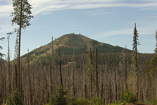
Black Butte is an extinct stratovolcano in the U.S. state of Oregon. Located in Jefferson County, it is part of Deschutes National Forest. Black Butte forms part of the Cascade volcanic arc. The butte lies just south of the Metolius Springs, which merge to form the headwaters of the Metolius River. The Metolius River's basin sustains a wide array of plant life, large and small mammals, and more than 80 bird species.

<span class="mw-page-title-main">Diamond Peak (Oregon)</span> Mountain in the United States

Diamond Peak is a volcano in Klamath and Lane counties of central Oregon in the United States. It is a shield volcano, though it might also be considered a modest stratocone. Diamond Peak forms part of the Cascade Volcanic Arc, a segment of the Cascade Range in western North America extending from southern British Columbia through Oregon to Northern California. Reaching an elevation of 8,748 feet (2,666 m), the mountain is located near Willamette Pass in the Diamond Peak Wilderness within the Deschutes and Willamette national forests. Surrounded by coniferous forest and visible in the skyline from foothills near Eugene, Diamond Peak offers a few climbing routes and can be scrambled. Diamond Peak is one of Oregon's Matterhorns.

<span class="mw-page-title-main">Mount Washington Wilderness</span>

The Mount Washington Wilderness is a wilderness area located on and around Mount Washington in the central Cascade Range of Oregon in the United States. The wilderness was established in 1964 and comprises 54,278 acres (219.66 km2) of the Willamette National Forest and Deschutes National Forest. It is administered by the U.S. Forest Service.

<span class="mw-page-title-main">Olallie Butte</span> Mountain in United States of America

Olallie Butte is a steep-sided shield volcano in the Cascade Range of the northern part of the U.S. state of Oregon. It is the largest volcano and highest point in the 50-mile (80 km) distance between Mount Hood and Mount Jefferson. Located just outside the Olallie Scenic Area, it is surrounded by more than 200 lakes and ponds fed by runoff, precipitation, and underground seepage, which are popular spots for fishing, boating, and swimming. The butte forms a prominent feature in the Mount Jefferson region and is usually covered with snow during the winter and spring seasons.

<span class="mw-page-title-main">Hoodoo Butte</span> Mountain in Oregon, United States

Hoodoo Butte is a cinder cone butte in the Cascade Range of northern Oregon, located near Santiam Pass. Immediately to the east lies Hayrick Butte, a prime example of a tuya; the two mountains' names were likely mistaken for each other, but stuck with them over time. The area has been subjected to a number of historic fires. Hoodoo is sometimes considered a subfeature of the Mount Washington shield volcano, and it forms part of the Sisters Reach, which extends from South Cinder Peak to Crane Prairie Reservoir, running for 56 miles (90 km). This region has a high vent density, with many mafic volcanoes of Pleistocene to Holocene age, such as Hoodoo. While Hoodoo has an intact summit crater that was blocked from erosion by glaciers, it has an irregular topography, giving it an open appearance.

<span class="mw-page-title-main">Hayrick Butte</span> Mountain in United States of America

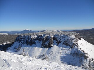
Hayrick Butte is a tuya, a type of subglacial volcano, in Linn County, Oregon. Located in the Willamette National Forest near Santiam Pass, it lies adjacent to the cinder cone Hoodoo Butte, which has a ski area. Hayrick Butte likely formed when lava erupted underneath an overlying glacier or ice sheet, producing the flat top with near-vertical walls along the ice-contact margin as the lava cooled and hardened. Hayrick Butte has a nearly flat plateau about 0.5 miles (0.80 km) across and steep walls rising about 700 feet (0.21 km) above its surroundings. A cartographer accidentally switched the names for nearby Hoodoo Butte and Hayrick Butte; the word "hoodoo" usually refers to rock piles and pinnacles like those observed at Hayrick Butte.

<span class="mw-page-title-main">Black Crater</span> Shield volcano in central Oregon, United States

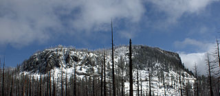
Black Crater is a shield volcano in the Western Cascades in Deschutes County, Oregon. Located near McKenzie Pass, the volcano has a broad conical shape with gentle slopes. The volcano likely formed during the Pleistocene and has not been active within the last 50,000 years. Eruptive activity at the volcano produced mafic lava flows made of basaltic andesite and olivine basalt; it also formed a number of cinder cones. A normal fault occurs on the western side of the volcano, trending north–south. The volcano has been eroded by glaciers, which carved a large cirque into the northeastern flank of the mountain, forming its current crater.

<span class="mw-page-title-main">Hogg Rock</span> Mountain in the Cascade Range of northern Oregon

Hogg Rock is a tuya volcano and lava dome in the Cascade Range of northern Oregon, United States, located close to Santiam Pass. Produced by magma with an intermediate andesite composition, it has steep slopes and thick glassy margins. Hogg Rock exhibits normal magnetic polarity and is probably about 80,000 years old.

<span class="mw-page-title-main">Blue Lake Crater</span> Volcanic crater in Oregon, United States

Blue Lake Crater is a maar, or a broad, low-relief volcanic crater, in the U.S. state of Oregon. Located in Jefferson County, it consists of three overlapping craters, which hold Blue Lake. The drainage basin for Blue Lake has very steep, forested slopes and is mostly part of the explosion crater left by the volcano's eruption. The volcano lies within the Metolius River basin, which supports a wide array of plant life, large and small mammals, and more than 80 bird species. In 2009, Governor of Oregon Ted Kulongoski signed a bill designating the Metolius River basin as an area of critical concern, preventing large-scale development on the land and protecting its wildlife.

<span class="mw-page-title-main">Sand Mountain Volcanic Field</span> Volcanic field in Oregon

The Sand Mountain Volcanic Field is a volcanic field in the upper McKenzie River watershed, located in the United States in Oregon. Part of the Cascade Volcanic Arc, it lies southwest of Mount Jefferson and northwest of Belknap Crater and Mount Washington. Its highest elevation is 5,463 feet (1,665 m).

References

  1. 1 2 3 4 5 6 7 8 9 10 11 Wood & Kienle 1990, p. 181.
  2. 1 2 3 4 Hildreth 2007, p. 7.
  3. 1 2 3 "Mount Washington". NGS Data Sheet. National Geodetic Survey, National Oceanic and Atmospheric Administration, United States Department of Commerce . Retrieved November 11, 2018.
  4. 1 2 Hildreth 2007, p. 44.
  5. 1 2 3 4 5 6 Harris 2005, p. 163.
  6. 1 2 James, Manga & Rose 1999, p. 823.
  7. 1 2 3 4 5 6 7 8 Wuerthner 2003, p. 137.
  8. "Feature Detail Report for: Mount Washington". Geographic Names Information System. November 11, 2018. Archived from the original on November 12, 2018. Retrieved November 11, 2018.
  9. 1 2 3 4 5 6 Taylor & Causey 1984, p. 893.
  10. Wood & Kienle 1990, p. 182.
  11. 1 2 3 Taylor, Causey & MacLeod 1983, p. 4.
  12. 1 2 3 4 5 6 "Washington". Global Volcanism Program . Smithsonian Institution. 2013. Archived from the original on November 15, 2018. Retrieved November 12, 2018.
  13. Voth 1963, p. 7.
  14. Harris 2005, p. 162.
  15. 1 2 3 4 5 Wuerthner 2003, p. 135.
  16. Taylor, Causey & MacLeod 1983, p. 6.
  17. Taylor 1981, p. 77.
  18. Stearns 1929, p. 171.
  19. 1 2 3 4 5 "Mount Washington Wilderness: Deschutes". United States Forest Service. 2018. Archived from the original on November 13, 2018. Retrieved November 12, 2018.
  20. Taylor, Causey & MacLeod 1983, pp. 3–4.
  21. 1 2 Taylor, Causey & MacLeod 1983, p. 2.
  22. Taylor, Causey & MacLeod 1983, p. 10.
  23. 1 2 Taylor, Causey & MacLeod 1983, p. 7.
  24. 1 2 3 4 Taylor & Causey 1984, p. 895.
  25. 1 2 Taylor, Causey & MacLeod 1983, p. 8.
  26. Wuerthner 2003, p. 138.
  27. 1 2 Sellars 1923, pp. 69–75.
  28. 1 2 Marsh 2002, p. 216.
  29. Schmidt & Grunder 2009, p. 643.
  30. Schmidt & Grunder 2009, pp. 643–644.
  31. Keach et al. 1989, pp. 783–784.
  32. Taylor, Causey & MacLeod 1983, pp. 4–5.
  33. 1 2 Harris 2005, p. 157.
  34. Hildreth 2007, p. 23.
  35. Sherrod et al. 2004, p. 31.
  36. 1 2 Taylor, Causey & MacLeod 1983, p. 5.
  37. Hildreth 2007, p. 27.
  38. 1 2 3 "Washington". Volcano World. Oregon State University. 2018. Archived from the original on November 12, 2018. Retrieved November 12, 2018.
  39. Sherrod et al. 2004, p. 22.
  40. Scott 1977, p. 121.
  41. Williams 1944, p. 41.
  42. Scott 1977, p. 119.
  43. Sherrod et al. 2004, p. 6.
  44. Taylor 1965, p. 137.
  45. 1 2 Hughes 1990, p. 19623.
  46. Hughes 1990, p. 19627.
  47. 1 2 Schmidt & Grunder 2009, p. 644.
  48. 1 2 3 Hughes & Taylor 1986, p. 1024.
  49. Hughes 1982, p. 72.
  50. 1 2 3 Hughes 1982, p. 65.
  51. Hughes 1982, p. 66.
  52. Sherrod et al. 2004, p. 7.
  53. 1 2 3 Sherrod et al. 2004, p. 8.
  54. Christensen & Cole 2000, p. 79.
  55. Wuerthner 2003, pp. 137–138.

Sources