The Aleutian Range is a major mountain range located in southwest Alaska. It extends from Chakachamna Lake to Unimak Island, which is at the tip of the Alaska Peninsula. It includes all of the mountains of the Peninsula. The Aleutian Range is special because of its large number of active volcanoes, which are also part of the larger Aleutian Arc. The mainland part of the range is about 600 miles (1000 km) long. The Aleutian Islands are (geologically) a partially submerged western extension of the range that stretches for another 1,600 km (1000 mi). However the official designation "Aleutian Range" includes only the mainland peaks and the peaks on Unimak Island. The range is almost entirely roadless wilderness. Katmai National Park and Preserve, a large national park within the range, must be reached by boat or plane.

Kiska is one of the Rat Islands, a group of the Aleutian Islands of Alaska. It is about 22 miles (35 km) long and varies in width from 1.5 to 6 miles. It is part of Aleutian Islands Wilderness and as such, special permission is required to visit it. The island has no permanent population.

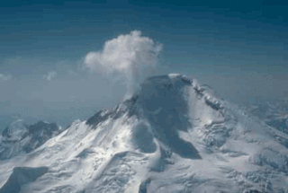
Redoubt Volcano, or Mount Redoubt, is an active stratovolcano in the largely volcanic Aleutian Range of the U.S. state of Alaska. Located at the head of the Chigmit Mountains subrange in Lake Clark National Park and Preserve, the mountain is just west of Cook Inlet, in the Kenai Peninsula Borough about 110 miles (180 km) southwest of Anchorage. At 10,197 feet (3,108 m), in just over 5 miles (8.0 km) Mount Redoubt attains 9,150 feet (2,790 m) of prominence over its surrounding terrain. It is the highest summit in the Aleutian Range. In 1976, Redoubt Volcano was designated as a National Natural Landmark by the National Park Service.

Shishaldin Volcano, or Mount Shishaldin, is a moderately active volcano on Unimak Island in the Aleutian Islands chain of Alaska in the United States. It is the highest mountain peak of the Aleutian Islands. The volcano's topographic contour lines are nearly perfect circles above 6,500 feet (1,981 m). The lower north and south slopes are somewhat steeper than the lower eastern and western slopes. The volcano is the westernmost of three large stratovolcanoes along an east–west line in the eastern half of Unimak Island.
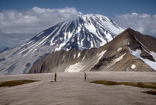
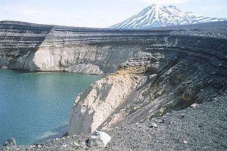
Mount Griggs, formerly known as Knife Peak Volcano, is a stratovolcano, which lies 10 km behind the volcanic arc defined by other Katmai group volcanoes. Although no historic eruptions have been reported from Mount Griggs, vigorously active fumaroles persist in a summit crater and along the upper southwest flank. The fumaroles on the southwest flank are the hottest, and some of the flank fumaroles can roar so loudly that they can be heard from the valley floor. The slopes of Mount Griggs are heavily mantled by fallout from the 1912 eruption of Novarupta volcano. The summit consists of three concentric craters, the lowest and largest of which contains a recent summit cone topped by two craters. The volume of the volcanic edifice is estimated at about 25 cubic kilometers (6.0 cu mi). Isotopic analysis indicates that the source of Griggs' magma is distinct from the other Katmai volcanoes.
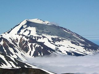
Mount Veniaminof is an active stratovolcano on the Alaska Peninsula. The mountain was named after Ioann Veniaminov (1797–1879), a Russian Orthodox missionary priest whose writings on the Aleut language and ethnology are still standard references. He is a saint of the Orthodox Church, known as Saint Innocent for the monastic name he used in later life.
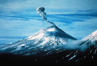
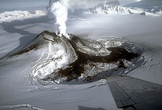
Pavlof Volcano is a stratovolcano of the Aleutian Range on the Alaska Peninsula. It has been one of the most active volcanoes in the United States since 1980, with eruptions recorded in 1980, 1981, 1983, 1986–1988, 1996–1997, 2007, 2013, twice in 2014, 2016, and is currently erupting as of August 2021. Basaltic andesite with SiO2 around 53% is the most common lava type. The volcano is monitored by the Alaska Volcano Observatory- a joint program of the United States Geological Survey (USGS), the Geophysical Institute of the University of Alaska Fairbanks (UAFGI), and the State of Alaska Division of Geological and Geophysical Surveys (ADGGS). With a threat score of 95, the threat from future eruptions is considered to be high; much of this threat comes from the possibility of disruption of nearby air routes by large releases of ash. The mountain currently has basic real-time monitoring, but the USGS would like to improve instrumentation at the site. The mountain shares a name with the nearby Pavlof Sister, which last erupted in 1786.

Mount Emmons is a post-caldera stratovolcano within the Emmons Lake caldera on the Alaska Peninsula within the Lake and Peninsula Borough, Alaska, United States.

The Makushin Volcano is an ice-covered stratovolcano located on Unalaska Island in the Aleutian Islands of the U.S. state of Alaska. With an elevation of 2,036 meters (6,680 ft), its summit is the highest point on the island. Makushin is one of the most active among the 52 historically active volcanoes of Alaska. It has erupted at least two dozen times over the past several thousand years, with the last eruption occurring in 1995.

Mount Vsevidof is a stratovolcano in the U.S. state of Alaska. Its summit is the highest point on Umnak Island, one of the eastern Aleutian Islands. Its symmetrical cone rises abruptly from its surroundings. The base of the volcano is around 10 km (6 mi) wide, steepening from about 15 degrees at 300 m (980 ft) altitude to around 30 degrees near the summit. Some glacial tongues have cut through narrow canyons up to 120 m (390 ft) deep, due to ice filling the crater and extending down the north and east flanks of the cone. Vsevidof's most recent eruption was caused by an earthquake on March 9, 1957. The mountain erupted on March 11, 1957, and the eruption ended the next day.

Mount Cleveland is a nearly symmetrical stratovolcano on the western end of Chuginadak Island, which is part of the Islands of Four Mountains just west of Umnak Island in the Fox Islands of the Aleutian Islands of Alaska. Mt. Cleveland is 5,675 ft (1,730 m) high, and one of the most active of the 75 or more volcanoes in the larger Aleutian Arc. Aleutian natives named the island after their fire goddess, Chuginadak, who they believed inhabited the volcano. In 1894 a team from the United States Coast and Geodetic Survey visited the island and gave Mount Cleveland its current name, after then-president Grover Cleveland.
Iliamna Volcano, or Mount Iliamna, is a glacier-covered stratovolcano in the largely volcanic Aleutian Range in southwest Alaska. Located in the Chigmit Mountain subrange in Lake Clark National Park and Preserve, the 10,016-foot (3,053 m) volcano lies approximately 134 miles (215 km) southwest of Anchorage on the west side of lower Cook Inlet. It is the 25th most prominent peak in the United States.
Korovin Volcano is one of four volcanic centers of the Atka Volcanic Complex, located near the town of Atka on the northeast part of Atka Island in the Aleutian Islands chain, Alaska, United States. At 5,030 feet (1,530 m), Korovin is the highest point on the island.

Isanotski Peaks or Isanotski Volcano, known locally as "Ragged Jack", is a multipeaked mountain on Unimak Island, the easternmost Aleutian Island in Alaska, United States. It is an old, highly dissected stratovolcano, lying about 10 miles (16 km) east of Shishaldin Volcano, the highest peak in the Aleutian Islands. Its height is also often given as 8,025 feet.

The Alaska Volcano Observatory (AVO) is a joint program of the United States Geological Survey (USGS), the Geophysical Institute of the University of Alaska Fairbanks (UAFGI), and the State of Alaska Division of Geological and Geophysical Surveys (ADGGS). AVO was formed in 1988, and uses federal, state, and university resources to monitor and study Alaska's volcanology, hazardous volcanoes, to predict and record eruptive activity, and to mitigate volcanic hazards to life and property. The Observatory website allows users to monitor active volcanoes, with seismographs and webcameras that update regularly. AVO now monitors more than 20 volcanoes in Cook Inlet, which is close to Alaskan population centers, and the Aleutian Arc due to the hazard that plumes of ash pose to aviation.
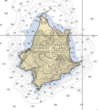
Bobrof Island is one of the Andreanof Islands subgroup of the Aleutian Islands in southwestern Alaska, United States. Bobrof Island is a small, uninhabited island about 9 miles (14 km) north and west of Kanaga Island, and 7 miles (11 km) northeast of Cape Sudak on Tanaga Island. Bobrof Island is 2.6 miles (4.2 km) long and 1.8 miles (2.9 km) wide with an area of 3 square miles (7.8 km2), and consists primarily of the 2,421-foot (738 m) high Bobrof Volcano. The volcanic crater, or cone, has been heavily dissected. Underwater deposits adjacent to the island's northeast flank suggest an immense debris-avalanche has taken place.

Mount Moffett is a mountainous stratovolcano that forms the summit of Adak Island of the Aleutian Islands in the U.S. state of Alaska. Its peak reaches 3,924 feet (1,196 m). It is heavily glaciated and is made primarily of high alumina basalt and andesite. It has never had an eruption in recorded history. The southern flank of the mountain is assumed to be its youngest side. In comparison to other Aleutian stratovolcanoes, Moffett is a small vent, characteristic of its mixed composition.

Buldir Volcano is an inactive stratovolcano located on Buldir Island in the Aleutian Islands of Alaska, once described as "the westernmost volcanic center of the present Pleistocene to Recent Aleutian volcanic front." It shares the island with a younger stratovolcano entitled East Cape.

Mount Gareloi, or Gareloi Volcano, is a stratovolcano in the Aleutian Islands of Alaska, United States, about 1,259 miles (2,026 km) from Anchorage. Gareloi is located on Gareloi Island, and comprises most of its land mass. The island also has two small glaciers which protrude to the northwest and southeast.

