Related Research Articles
East Mountain is a city in Upshur and Gregg counties, Texas, United States. The population was 899 at the 2020 census, up from 797 at the 2010 census.

Montague is a census-designated place and unincorporated community in Montague County, Texas, United States. It is the county seat of Montague County and had an estimated population of 400 in 2000, according to the Handbook of Texas. Its population was 304 as of the 2010 census.

The Tularosa Basin is a graben basin in the Basin and Range Province and within the Chihuahuan Desert, east of the Rio Grande in southern New Mexico and West Texas, in the Southwestern United States.

Al-Hasan Stadium is a multi-purpose stadium in Irbid, Jordan, located next to Irbid's Yarmouk University. It is currently used mostly for football matches. The stadium holds 12,000 people.
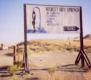
Mercey Hot Springs is an unincorporated community and historical hot springs resort in the Little Panoche Valley of Fresno County, central California, about 60 miles (97 km) west-southwest of Fresno.
Bootleg Canyon Mountain Bike Park is an internationally renowned venue located in Bootleg Canyon within the northern section of Boulder City, Nevada, in the desert near Lake Mead and Hoover Dam. Consisting of a variety of different types of trails including cross-country (XC) and downhill (DH), the park was created by artist and cycling enthusiast Brent Thomson. International Mountain Bicycling Association has designated Bootleg Canyon as an "Epic ride".
Carlton Peak is a summit in the Sawtooth Mountains in southern Tofte Township, Cook County, in northeastern Minnesota in the United States. In 1848, Reuben B. Carlton of Fond du Lac, Minnesota, ascended the peak with Col. Charles Whittlesey, who was participating in a geological survey expedition. In appreciation, Whittlesey named the mountain in Carlton's honor. Carlton Peak is now a Day Use area of Temperance River State Park and requires a valid Minnesota State Parks sticker per the sign on the road on the south side of the peak.
Piggen is an unincorporated community in Accomack County, Virginia.

The Cochetopa Hills are a ridge of uplands on the Continental Divide in Saguache County, southern Colorado, United States.
Crystal Bay-Sunset is a hamlet in the Canadian province of Saskatchewan.
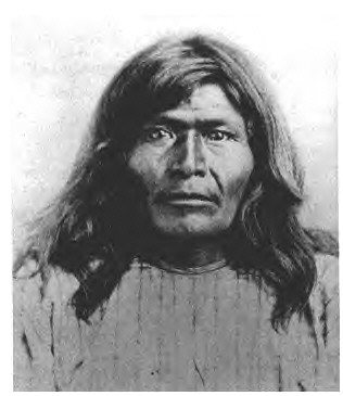
Victorio's War, or the Victorio Campaign, was an armed conflict between the Apache followers of Chief Victorio, the United States, and Mexico beginning in September 1879. Faced with arrest and forcible relocation from his homeland in New Mexico to San Carlos Indian Reservation in southeastern Arizona, Victorio led a guerrilla war across southern New Mexico, west Texas and northern Mexico. Victorio fought many battles and skirmishes with the United States Army and raided several settlements until the Mexican Army killed him and most of his warriors in October 1880 in the Battle of Tres Castillos. After Victorio's death, his lieutenant Nana led a raid in 1881.

San Pascual is a ward (barrio) of Madrid belonging to the district of Ciudad Lineal.
Temple Mountain is a 6,693-foot (2,040 m) summit in Boundary County, Idaho, United States.

The Fort Lowell in or near Los Ojos, New Mexico, was established in 1866 and operated until 1869. It protected settlements in the area of Tierra Amarilla from the Southern Utes. It was at first named Camp Plummer and was garrisoned by New Mexico volunteers, some of whose descendants remain in its area.

Oscura Mountains, originally known to the Spanish as the Sierra Oscura, are a ridge of mountains, trending north and south, east of the Jornada del Muerto and west of the Tularosa Valley. It is located in Socorro County and Lincoln County, New Mexico. Their highest elevation is Oscura Peak at 8,625 feet. Its southern end is at 33°30′30″N106°18′45″W and its north end is at 33°49′15″N106°22′20″W near North Oscura Peak.
San Pascual Pueblo was a Piro pueblo south and east of Socorro, in Socorro County, New Mexico, United States. Its ruins lie on the east bank of the Rio Grande, on a butte, on the western slope of the Little San Pascual Mountain, overlooking the river, near the eastern boundary of the Bosque del Apache National Wildlife Refuge.
References
Coordinates: 33°43′14″N106°51′37″W / 33.72056°N 106.86028°W
| | This New Mexico state location article is a stub. You can help Wikipedia by expanding it. |