
Catron County is a county in the U.S. state of New Mexico. As of the 2020 census, the population was 3,579, making it New Mexico's third-least populous county. Its county seat is Reserve. Catron County is New Mexico's largest county by area.

The Gila River is a 649-mile-long (1,044 km) tributary of the Colorado River flowing through New Mexico and Arizona in the United States. The river drains an arid watershed of nearly 60,000 square miles (160,000 km2) that lies mostly within the U.S., but also extends into northern Sonora, Mexico.

The Salt River is a river in Gila and Maricopa counties in Arizona, United States, that is the largest tributary of the Gila River. The river is about 200 miles (320 km) long. Its drainage basin covers about 13,700 square miles (35,000 km2). The longest of the Salt River's many tributaries is the 195-mile (314 km) Verde River. The Salt's headwaters tributaries, the Black River and East Fork, increase the river's total length to about 300 miles (480 km). The name Salt River comes from the river's course over large salt deposits shortly after the merging of the White and Black Rivers.
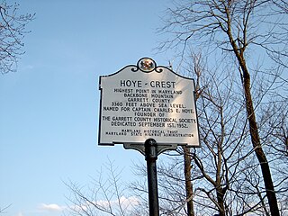
Backbone Mountain is a ridge of the Allegheny Mountains of the central Appalachian Mountain Range. It is situated in the U.S. states of West Virginia and Maryland and forms a portion of the Eastern Continental Divide. Within the state of Maryland, Backbone Mountain reaches an elevation of 3,360 feet or 1,024 metres, making it Maryland's highest point.

The Angeles National Forest (ANF) of the U.S. Forest Service is located in the San Gabriel Mountains and Sierra Pelona Mountains, primarily within Los Angeles County in southern California. The ANF manages a majority of the San Gabriel Mountains National Monument.
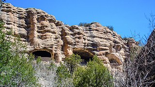
Gila Cliff Dwellings National Monument is a U.S. National Monument created to protect Mogollon cliff dwellings in the Gila Wilderness on the headwaters of the Gila River in southwest New Mexico. The 533-acre (2.16 km2) national monument was established by President Theodore Roosevelt through executive proclamation on November 16, 1907. It is located in the extreme southern portion of Catron County. Visitors can access the monument by traveling northbound from Silver City, New Mexico, 45 miles (72 km) on NM 15.

The George Washington and Jefferson National Forests is an administrative entity combining two U.S. National Forests into one of the largest areas of public land in the Eastern United States. The forests cover 1.8 million acres (2,800 sq mi) of land in the Appalachian Mountains of Virginia, West Virginia, and Kentucky. Approximately 1 million acres (1,600 sq mi) of the forest are remote and undeveloped and 139,461 acres (218 sq mi) have been designated as wilderness areas, which prohibits future development.

Boise National Forest is a National Forest covering 2,203,703 acres (8,918.07 km2) of the U.S. state of Idaho. Created on July 1, 1908, from part of Sawtooth National Forest, it is managed by the U.S. Forest Service as five units: the Cascade, Emmett, Idaho City, Lowman, and Mountain Home ranger districts.

The Shasta–Trinity National Forest is a federally designated forest in northern California, United States. It is the largest National Forest in California and is managed by the U.S. Forest Service. The 2,210,485 acre forest encompasses five wilderness areas, hundreds of mountain lakes and 6,278 miles (10,103 km) of streams and rivers. Major features include Shasta Lake, the largest man-made lake in California and Mount Shasta, elevation 14,179 feet (4,322 m).

The Gila National Forest is a United States National Forest in New Mexico. Established in 1905, it now covers approximately 2,710,659 acres (10,969.65 km2), making it the sixth largest National Forest in the continental United States. The Forest administration also manage the part of the Apache National Forest in New Mexico which covers 614,202 acres for a total of 3.3 million acres managed by the Gila National Forest. Within the forest, the Gila Wilderness was established in 1924 as the US's first designated wilderness. The Aldo Leopold Wilderness and Blue Range Wilderness are also found within its borders. The Blue Range Primitive Area lies within Arizona in the neighboring Apache National Forest.

Reddish Knob of Shenandoah Mountain is one of the highest points in Virginia, rising 4,397 feet (1,340 m). A narrow, paved road reaches the summit from Harrisonburg, Virginia.
McKnight Mountain is the highest peak in the Black Range of southwestern New Mexico, in the southwestern United States. It is located about 30 miles (48 km) northeast of Silver City, in the Aldo Leopold Wilderness of the Gila National Forest.
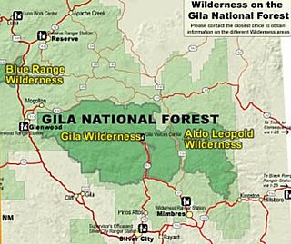
Gila Wilderness was designated the world's first wilderness area on June 3, 1924. Along with Aldo Leopold Wilderness and Blue Range Wilderness, the 558,014 acre wilderness is part of New Mexico's Gila National Forest. The wilderness is approximately 27 miles (43 km) from north to south and 39 miles (63 km) east to west.
Whitewater Baldy is the highest point of the Mogollon Mountains and the 3rd highest mountain in Southern New Mexico, after Sierra Blanca Peak and Lincoln County's Lookout Mountain. It is located in Catron County in the Gila Wilderness, part of the Gila National Forest. It lies about 15 miles (24 km) east of the town of Glenwood.
The Black Butte River is located in the Mendocino National Forest of northern California in Glenn and Mendocino counties. It is a tributary to the Middle Fork Eel River and flows northward for 24 miles (39 km) from its headwaters near Round Mountain to the confluence with the Middle Fork Eel River. The Northern California Coastal Wild Heritage Wilderness Act of 2006 added 21 miles (34 km) of the Black Butte River to the National Wild and Scenic Rivers System, of which 17.5 miles (28.2 km) are Wild status and 3.5 miles (5.6 km) are Scenic.

The North Fork Eel River is the smallest of four major tributaries of the Eel River in northwestern California in the United States. It drains a rugged wilderness area of about 286 square miles (740 km2) in the California Coast Ranges, and flows through national forests for much of its length. Very few people inhabit the relatively pristine watershed of the river; there are no operational stream gauges and only one bridge that crosses the river, near the boundary between Trinity and Mendocino Counties.

The White Mountain Wilderness is a 46,963 acre designated wilderness area managed by the United States Forest Service. Located in the Smokey Bear Ranger District of the Lincoln National Forest, the White Mountain Wilderness lies in the Sierra Blanca mountains of south central New Mexico, approximately 15 miles (24 km) north northwest of the town of Ruidoso.
Lookout Mountain, elevation 6,536 feet (1,992 m), is the second highest peak in Oregon's Mount Hood National Forest and the highest point in Badger Creek Wilderness. It sits about 8 miles (13 km) east-southeast of Mount Hood, separated from it by the valley of the East Fork Hood River.
The Matilija Wilderness is a 29,207-acre (11,820 ha) wilderness area in Ventura and Santa Barbara Counties, Southern California. It is managed by the U.S. Forest Service, being situated within the Ojai Ranger District of the Los Padres National Forest. It is located adjacent to the Dick Smith Wilderness to the northwest and the Sespe Wilderness to the northeast, although it is much smaller than either one. The Matilija Wilderness was established in 1992 in part to protect California condor habitat.

Mount Nebo is a 8,261-foot (2,518 m) mountain in the Eagle Cap Wilderness of Oregon, in the United States. Named after the biblical Mount Nebo overlooking Israel, which is said to be the place of Moses' death. It is the centerpiece of the Imnaha Divide, inside the Wallowa–Whitman National Forest. Mount Nebo is one of the important areas where sheep and cattle graze throughout Eagle Cap Wilderness.
