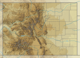
Colorado is a state in the Mountain West sub-region of the Western United States. It encompasses most of the Southern Rocky Mountains, as well as the northeastern portion of the Colorado Plateau and the western edge of the Great Plains. Colorado is the eighth most extensive and 21st most populous U.S. state. The United States Census Bureau estimated the population of Colorado at 5,839,926 as of July 1, 2022, a 1.15% increase since the 2020 United States census.

The City of Northglenn is a home rule municipality located in Adams and Weld counties, Colorado, United States. Northglenn is a part of the Denver–Aurora–Lakewood, CO Metropolitan Statistical Area. As of the 2020 census the city's population was 38,131. It was built as a master planned community in 1959 by Jordon Perlmutter.

The Town of Fraser is a Statutory Town located in Grand County, Colorado, United States. The town population was 1,400 at the 2020 United States Census, a +14.38% increase since the 2010 United States Census. The town is situated in Middle Park in the valley of the Fraser River along U.S. Highway 40. Its location northwest of Winter Park, the location of a popular ski resort, has provided growth in recent years with new condominium and other real estate developments.

The Town of Grand Lake is a statutory town located in Grand County, Colorado, United States. The town population was 410 at the 2020 United States Census.

The Town of Dillon is a home rule municipality located in Summit County, Colorado, United States. The town population was 1,064 at the 2020 United States Census, a +17.70% increase since the 2010 United States Census. Dillon is a part of the Breckenridge, CO Micropolitan Statistical Area.

Rocky Mountain National Park is an American national park located approximately 55 mi (89 km) northwest of Denver in north-central Colorado, within the Front Range of the Rocky Mountains. The park is situated between the towns of Estes Park to the east and Grand Lake to the west. The eastern and western slopes of the Continental Divide run directly through the center of the park with the headwaters of the Colorado River located in the park's northwestern region. The main features of the park include mountains, alpine lakes and a wide variety of wildlife within various climates and environments, from wooded forests to mountain tundra.

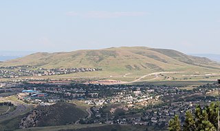
Roxborough State Park is a state park of Colorado, United States, known for dramatic red sandstone formations. Located in Douglas County 20 miles (32 km) south of Denver, Colorado, the 3,339-acre (13.51 km2) park was established in 1975. In 1980 it was recognized as a National Natural Landmark.
Pathfinder Reservoir is located in the U.S. state of Wyoming on the North Platte River between Casper and Rawlins. It sits 47 miles (76 km) southwest of Casper, in Carbon County and Natrona County. The reservoir was created by Pathfinder Dam and has a storage capacity of 1,016,000 acre-feet (1.253×10⁹ m3). The shoreline consists of 117 miles (188 km). Much of the water used to serve the 335,000 acre (1360 km2) North Platte Project is stored here. Some of the water in the reservoir is released to satisfy other water rights and to operate power plants downstream of the reservoir. Much of the Pathfinder Reservoir is included in the Pathfinder National Wildlife Refuge. Pathfinder Reservoir is the site of the only established population of the Macedonian Ohrid Trout (S. letnica) in the United States.

The City and County of Denver, Colorado, is located at 39°43'35" North, 104°57'56" West in the Colorado Front Range region. The Southern Rocky Mountains lie to the west of Denver and the High Plains lie to the east.

Blue Mesa Reservoir is an artificial reservoir located on the upper reaches of the Gunnison River in Gunnison County, Colorado. The largest lake located entirely within the state, Blue Mesa Reservoir was created by the construction of Blue Mesa Dam, a 390-foot tall earthen fill dam constructed on the Gunnison by the U.S. Bureau of Reclamation in 1966 for the generation of hydroelectric power. Managed as part of the Curecanti National Recreation Area, a unit of the National Park Service, Blue Mesa Reservoir is the largest lake trout and Kokanee salmon fishery in Colorado.

Arizona is a landlocked state situated in the southwestern region of the United States of America. It has a vast and diverse geography famous for its deep canyons, high- and low-elevation deserts, numerous natural rock formations, and volcanic mountain ranges. Arizona shares land borders with Utah to the north, the Mexican state of Sonora to the south, New Mexico to the east, and Nevada to the northwest, as well as water borders with California and the Mexican state of Baja California to the southwest along the Colorado River. Arizona is also one of the Four Corners states and is diagonally adjacent to Colorado.

With a total area of 121,590 square miles (314,900 km2), New Mexico is the fifth-largest state, after Alaska, Texas, California, and Montana. Its eastern border lies along 103°W longitude with the state of Oklahoma, and 2.2 miles west of 103°W longitude with Texas. On the southern border, Texas makes up the eastern two-thirds, while the Mexican states of Chihuahua and Sonora make up the western third, with Chihuahua making up about 90% of that. The western border with Arizona runs along the 109° 03'W longitude. The southwestern corner of the state is known as the Bootheel. The 37°N parallel forms the northern boundary with Colorado. The states of New Mexico, Colorado, Arizona, and Utah come together at the Four Corners in New Mexico's northwestern corner. Its surface water area is about 292 square miles (760 km2).

John Martin Reservoir State Park is a state park in Colorado. It contains John Martin Reservoir, which is the second largest body of water in Colorado by capacity. It is also known for being a prime birdwatching location. Bent County, Colorado has been documented to have over 400 different species of birds. The namesake reservoir of the park is created by a 118-foot tall (36 m) and 2.6-mile long dam (4.2 km), which goes by the name of John Martin Dam.
The City of Lakewood is the home rule municipality that is the most populous municipality in Jefferson County, Colorado, United States. The city population was 155,984 at the 2020 U.S. Census, making Lakewood the fifth most populous city in Colorado and the 167th most populous city in the United States. Lakewood is a suburb of Denver and is the principal city of the Denver–Aurora–Lakewood, CO Metropolitan Statistical Area and a major city of the Front Range Urban Corridor.
Antero Reservoir is a reservoir in the US state of Colorado. It was created by the first dam placed on the South Platte River in Park County, central Colorado. It is owned by Denver Water and supplies drinking water to the greater Denver metro region almost 140 miles (230 km) away.
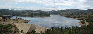
Gross Reservoir, located in Boulder County, Colorado, is owned and operated by Denver Water. Completed in 1954, the reservoir has a surface area of 440 acres, and the spillway sits at 7,225 feet elevation.
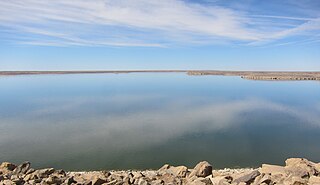
John Martin Reservoir is a reservoir on the Arkansas River in southeastern Colorado. Built and managed by the U.S. Army Corps of Engineers, it is used for flood control, irrigation, and recreation. John Martin Reservoir State Park lies on its shore.

The 2015–16 North American winter was not as frigid across North America and the United States as compared to the 2013–14 and 2014–15 winters. This was mainly due to a strong El Niño, which caused generally warmer-then-average conditions. However, despite the warmth, significant weather systems still occurred, including a snowstorm and flash flooding in Texas at the end of December and a large tornado outbreak at the end of February. The main event of the winter season, by far and large, was when a crippling and historic blizzard struck the Northeastern United States in late January, dumping up to 3 feet of snow in and around the metropolitan areas. Several other smaller snow events affected the Northeast as well, but for the most part the heaviest snowstorms and ice stayed out further west, such as a severe blizzard in western Texas in late December, and a major late-season snowstorm in Colorado in mid-April.

Climate change in Colorado encompasses the effects of climate change, attributed to man-made increases in atmospheric carbon dioxide, in the U.S. state of Colorado.

The southwestern North American megadrought is an ongoing megadrought in the southwestern region of North America that began in 2000. 23 years in length, the drought is the driest multi-decade period the region has seen since at least 800 CE. The megadrought has prompted the declaration of a water shortage at Lake Mead, the largest reservoir in the United States. Climate change models project drier conditions in the region through the end of the 21st century, though climate change mitigation may avoid the most extreme impacts.