Matamoros Municipality, Tamaulipas

Last updated
Matamoros
Heroica Matamoros.png
Municipio de Matamoros.jpg
Municipality of Matamoros in Tamaulipas
CountryFlag of Mexico.svg  Mexico
State Tamaulipas
Municipal seat Matamoros
Population
 (2010)
  Total489,193

Matamoros is a municipality located in the Mexican state of Tamaulipas. Its municipal seat is the City of Matamoros.

Contents

Towns and villages

The largest localities (cities, towns, and villages) are: [1]

Name2010 Census Population
Matamoros 449,815
Ramírez3,743
El Control3,136
Las Higuerillas2,129
CEFERESO Número 32,082
Santa Adelaida1,754
Estación Sandoval1,146
El Galaneño1,057
Total Municipality489,193
Grassland habitat on the road to Mezquital, Municipality of Matamoros, Tamaulipas, Mexico (18 March 2009) Grassland habitat on the road to Mezquital, Municipality of Matamoros, Tamaulipas, Mexico (18 March 2009).jpg
Grassland habitat on the road to Mezquital, Municipality of Matamoros, Tamaulipas, Mexico (18 March 2009)

Adjacent municipalities and counties

Government

Mayors and municipal presidents

RulerTermOfficeNotes
Anastasio de Ayala [2] 1797–1799Mayor
José Cayetano Girón1800Intendant
Joséf de Gosearcochea1801Intendant
Vicente López de Heredia1803Intendant
José María Balli1804Intendant
Vicente López de Herrera1805Intendant
José de Jesús Solís1806–1807Intendant
Matías Morales1808Intendant
José Domingo de la Garza1809–1810Intendant
José de Jesús Solís1811–1812Intendant
José Marcelino Longoria1813Intendant
Felipe Roque de la Portilla1814Intendant
Blas María de la Garza1815Intendant
José Domingo de la Garza1816Intendant
Matías Morales1817Intendant
Ramón García1818Intendant
José Girón Girón1819Intendant
José de Jesús Solís1820Intendant
Juan José Chapa1820Intendant
Pedro José García1821Intendant
Domingo de la Garza1822Intendant
Andrés Saldaña1823Intendant
Juan B. García1824Intendant
José María Girón1825Intendant
José María Villarreal1826Prefect
Andrés Saldaña1827Prefect
Matías García1828Prefect
Domingo de la Garza1829Prefect
Manuel Galán1830Prefect
José María Villarreal1831Prefect
José María Girón1832Prefect
José Espiridión de la Rosa1833Prefect
Juan Longoria y Serna1834Prefect
Francisco García Treviño1835Prefect
Juan Nepomuceno Molano1836Prefect
José María Tovar1837Prefect
Constantino de Tavarna1838Prefect
Jorge López de Lara1839Prefect
Pedro de la Garza Treviño1840Prefect
Francisco Valdez1841Prefect
Victoriano T. Canales1842Prefect
Juan Longoria y Serna1843Prefect
Francisco Lojero1844Prefect
Mariano Treviño Garza1845Prefect
José María Girón1846–1847Prefect
Francisco Valdez1848Prefect
Victoriano T. Canales1849Prefect
Pedro José de la Garz1850Prefect
Macedonio Capistrán1851Prefect
Rafael Quintero1852Prefect
Albino López1853Prefect
Antonio Longoria Guerra1854Prefect
José María Cavazos1855–1856Prefect
Albino López1857Prefect
Leocadio Muñoz1858Prefect
Antonio Longoria1859Prefect
Matías Longoria1860Prefect
José María Cavazos1861–1862Prefect
Rafael Quintero1863Prefect
Agapito Longoria1864Prefect
Manuel Reyes Apresa1865–1866Prefect
Felipe Márquez1867Political chief
Juan Treviño Canales1868Political chief
Pedro Hinojosa1869–1870Political chief
Francisco F. Farías1871Political chief
Agustín Menchaca1872–1873Political chief
Juan N. Cortinas1874–1875Political chief
Baltazar Fuentes1876Political chief
Justo de la Garza1877Political chief
Maximiliano Chapa1878Political chief
Román de los Santos Coy1879Political chief
Felipe Salazar1880Political chief
Pedro Porras1881Political chief
Tomás Márquez1882–1883Political chief
Tomás Hinojosa1884–1885Political chief
Pedro Barrón1886Political chief
Melquiades Torres1887–1888Political chief
Andrés González1889Political chief
Cipriano Villanueva1890Political chief
Alfredo M. Passament1891Political chief
Rafael Solís1892–1893Political chief
Miguel Barragán1894Political chief
Antonio Cavazos1895Political chief
Jorge Stroder1896Political chief
Rafael Solís1897Political chief
Cipriano Villanueva1898Political chief
Rafael Solís1898–1905Political chief
Marcelino Rougier1906Political chief
Rafael Solís1907Political chief
Procopia Guerra1908–1909Political chief
Fructuoso Dávila1910–1911Political chief
Alfredo Pumarejo1912Political chief
Casimiro Sada1913Political chief
Armando Chapa Gómez1914–1915Political chief
Alejandro López1916Political chief
Rafael González1917Municipal president
Leónides Guerra1918–1919Municipal president
Salvador Cárdenas1920Municipal president
Miguel Elizondo1920Municipal president
Juan José de la Garza1920Municipal president
Miguel Elizondo1921Municipal president
Mriano García Schreck1921Municipal president
Miguel Elizondo1922Municipal president
Conrado Gutiérrez1923Municipal president
Luis R. Rendón1924Municipal president
Prudencio Ruiz1925Municipal president
Jesús María Cárdenas1926Municipal president
Valentín Ramírez1927Municipal president
Alfonso C. López1927Municipal president
Antonio Martínez1928Municipal president
Municipal presidentTermPolitical partyNotes
Guillermo Schears1929–1930 PNR Logo Partido Nacional Revolucionario.svg
Roberto F. García1931–1932PNR Logo Partido Nacional Revolucionario.svg
Primitivo Schears1933–1934PNR Logo Partido Nacional Revolucionario.svg
Rafael Munguía1935PNR Logo Partido Nacional Revolucionario.svg
Roberto F. García1936PNR Logo Partido Nacional Revolucionario.svg
Ladislao Cárdenas1937–1938PNR Logo Partido Nacional Revolucionario.svg
Francisco Zárate1938–1940 PRM Logo Partido de la Revolucion Mexicana.svg
Antonio de León1941–1942PRM Logo Partido de la Revolucion Mexicana.svg
Ladislao Cárdenas1943–1945PRM Logo Partido de la Revolucion Mexicana.svg
Ramiro T. Hernández1946 PRI PRI Party (Mexico).svg
Tomás Saro1947PRI PRI Party (Mexico).svg
Leónides Guerra1947–1948PRI PRI Party (Mexico).svg
Ernesto L. Elizondo1949–1951PRI PRI Party (Mexico).svg
Juan B. García1952PRI PRI Party (Mexico).svg Acting municipal president
Luis Ramírez de Alba1953–1954PRI PRI Party (Mexico).svg
Augusto G. Cárdenas1955–1957PRI PRI Party (Mexico).svg
Miguel Treviño Emparam1958–1960PRI PRI Party (Mexico).svg
Virgilio Garza Ruiz1961–1962PRI PRI Party (Mexico).svg
Isidro González Saldaña01-01-1963–31-12-1965PRI PRI Party (Mexico).svg
Enrique Siller Flores01-01-1966–31-12-1968PRI PRI Party (Mexico).svg
Óscar Guerra Elizondo01-01-1969–31-12-1971PRI PRI Party (Mexico).svg
Sergio Martínez Calderoni01-01-1972–31-12-1974PRI PRI Party (Mexico).svg
Guillermo Guajardo González01-01-1975–31-12-1977PRI PRI Party (Mexico).svg
Antonio Cavazos Garza01-01-1978–31-12-1980PRI PRI Party (Mexico).svg
Jorge Cárdenas González01-01-1981–31-12–1983 PARM LOGOTIPO PARM.jpg
Jesús Roberto Guerra Velazco01-01-1984–31-12-1986PRI PRI Party (Mexico).svg
Fernando Montemayor Lozano01-01-1987–31-12-1989PRI PRI Party (Mexico).svg
Jorge Cárdenas González01-01-1990–31-12-1992PRI PRI Party (Mexico).svg
Tomás Yarrington Ruvalcaba 01-01-1993–31-12-1995PRI PRI Party (Mexico).svg
Antonio Ramón Sampayo Ortiz [3] 01-01-1996–31-12-1998 PAN PAN Party (Mexico).svg
Homar Zamorano Ayala [4] 01-01-1999–31-12-2001PRI PRI Party (Mexico).svg
Mario Praxedis Zolezzi García [5] 01-01-2002–31-12-2004PRI PRI Party (Mexico).svg
Baltazar Manuel Hinojosa Ochoa [6] 01-01-2005–31-12-2007PRI PRI Party (Mexico).svg
Érick Agustín Silva Santos [7] 01-01-2008–31-12-2010PRI PRI Party (Mexico).svg
Panal PNA logo (Mexico).svg
Víctor Alfonso Sánchez Garza [8] 01-01-2011–2013PRI PRI Party (Mexico).svg
PVEM PVE logo (Mexico).png
Panal PNA logo (Mexico).svg
Leticia Salazar Vázquez [9] 2013–2016PAN PAN Party (Mexico).svg
Jesús Juan de la Garza Díaz del Guante [10] 2016–2018PRI PRI Party (Mexico).svg
PVEM PVE logo (Mexico).png
Panal PNA logo (Mexico).svg
Mario Alberto López Hernández [11] 2018–2021 PT PT logo (Mexico).svg
Morena Morena logo (Mexico).svg
PES PES logo (Mexico).svg
Coalition "Together We Will Make History"
Mario Alberto López Hernández [12] 2021–PT PT logo (Mexico).svg
Morena Morena logo (Mexico).svg
He was reelected on 06-06-2021

Related Research Articles

<span class="mw-page-title-main">Cocula, Jalisco</span> Municipality and city in Jalisco, Mexico

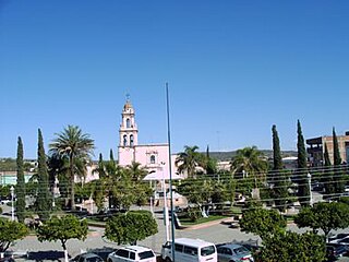
Cocula is a city and municipality in the Mexican state of Jalisco. It is located 35 mi (56 km) southwest of Guadalajara, on Mexico Highway 80. It sits at an elevation of 4,460 feet (1,360 m). According to the 2020 census, the population of the municipality was 29,267 with 16,550 inhabitants living in the city. Other important towns in the municipality are Cofradía de la Luz, La Sauceda, and Santa Teresa.

<span class="mw-page-title-main">Chiquilistlán</span> Municipality and town in Jalisco, Mexico

Chiquilistlán is a small town in the Mexican state of Jalisco. It is located in the Sierra Tapalpa mountains, at the foot of a hill called Chiquilichi, some 75 kilometres to the south-west of state capital Guadalajara.

<span class="mw-page-title-main">Amatitán</span> Municipality and town in Jalisco, Mexico

Amatitán is the head of a municipality in the Mexican state of Jalisco, and is home to one of the world's largest tequila distilleries.

<span class="mw-page-title-main">San Sebastián del Oeste</span> Municipality and city in Jalisco, Mexico

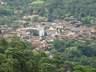
San Sebastián del Oeste is a town and municipality, located on the western part of Jalisco state, Mexico, between 20°39’45’’ - 21°02’30’’ N and 104°35’00’’ - 104°51’00’’ W, at a height of 1,480 metres (4,856 ft).

<span class="mw-page-title-main">Pihuamo</span> Municipality and city in Jalisco, Mexico

Pihuamo is a town and municipality located in the state of Jalisco in Mexico.

<span class="mw-page-title-main">Zapotlanejo</span> Place in Jalisco, Mexico

Zapotlanejo is a town and municipality in the Mexican state of Jalisco.

Victoria Municipality is a municipality located in the Mexican state of Tamaulipas. Its municipal seat is Ciudad Victoria.

<span class="mw-page-title-main">Teocaltiche</span> Municipality and Town in Jalisco, Mexico

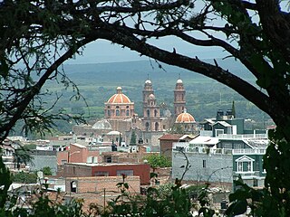
Teocaltiche is a town and municipality in the central-western Mexican state of Jalisco. It is located in the northeastern highlands region of Jalisco, commonly referred to in Spanish as "Los Altos de Jalisco". The grasshopper or "chapulin" is a popular icon for the town.

<span class="mw-page-title-main">Pantelhó</span> Municipality in Chiapas, Mexico

Pantelhó is a town and one of the 125 Municipalities of Chiapas, in southern Mexico.

<span class="mw-page-title-main">Zapotiltic</span> Place in Jalisco, Mexico

Zapotiltic is a town and municipality in the south region of the state of Jalisco, Mexico. It is approximately 115 km south of Guadalajara. According to the "Conteo de Poblacion y Vivienda of 2015" the town has a population of 29,190.

<span class="mw-page-title-main">Acatic</span> Municipality and Town in Jalisco, Mexico

Acatic is a town and municipality, in Jalisco in central-western Mexico. The municipality covers an area of 362.39 km². The town produces mainly Spanish style shingles, brick, adobe floor tile, chia, corn, and tequila. Pueblo Viejo Tequila is bottled near by. The town is the entry "gate" to Los Altos of Jalisco.

<span class="mw-page-title-main">Acatlán de Juárez</span> Municipality and city in Jalisco, Mexico

Acatlán de Juárez is a town and municipality, in Jalisco in central-western Mexico. The municipality covers an area of 166.68 km².

<span class="mw-page-title-main">Santa María del Oro, Jalisco</span> Municipality and city in Jalisco, Mexico

Santa María del Oro is a town and municipality, in Jalisco in central-western Mexico. The municipality covers an area of 403.88 km².

<span class="mw-page-title-main">Villa Purificación</span> Municipality and city in Jalisco, Mexico

Villa Purificación is a town and municipality, in Jalisco in central-western Mexico. The municipality covers an area of 1937.61 km².

<span class="mw-page-title-main">Zacoalco de Torres</span> City and Municipality in Jalisco, Mexico

Zacoalco de Torres, formerly Zacoalco, is a town and municipality in Jalisco, Mexico. The municipality covers an area of 491.27 km2. It is the primary production region of the equipal-style wood and pigskin furniture.

<span class="mw-page-title-main">Zapotitlán de Vadillo</span> Municipality and city in Jalisco, Mexico

Zapotitlán de Vadillo is a town and municipality, in Jalisco in central-western Mexico. The municipality covers an area of 480.74 km².

<span class="mw-page-title-main">San Martín de Hidalgo Municipality, Jalisco</span> Municipality in Jalisco, Mexico

San Martín de Hidalgo Municipality is a municipality located in the Región Valles of the state of Jalisco, Mexico. As of 2010, the population was 26,306. The municipal seat is San Martín de Hidalgo. Other administrative communities include 5 delegations and 18 agencies.

San Ignacio Cerro Gordo is a municipality in Jalisco, Mexico. It was established by the Congress of the State of Jalisco, on 1 January 2007 out of Arandas. Decree Number 20371 was published in the Periódico Oficial El Estado de Jalisco, on 30 December 2003, three years before the creation of this municipality, to allow its municipal authorities to be elected by the citizens in the election of municipal presidents on 2 July 2006.

<span class="mw-page-title-main">Cabo Corrientes Municipality</span> Place in Jalisco, Mexico

Cabo Corrientes is a municipality in the state of Jalisco, Mexico. It is named after the cape of the same name, Cabo Corrientes. The municipal seat is a town named El Tuito.

References

  1. 2010 census tables: INEGI Archived 2013-05-02 at the Wayback Machine
  2. "Enciclopedia de los Municipios y Delegaciones de México. Tamaulipas. Matamoros" (in Spanish). Retrieved 4 November 2021.
  3. "Instituto Estatal Electoral de Tamaulipas. Resultados del cómputo final de ayuntamientos. Elecciones 1995. Matamoros. PAN: 58907 votos. PRI: 53663 votos. PRD: 1359 votos" (PDF) (in Spanish). Retrieved 4 November 2021.
  4. "Instituto Estatal Electoral de Tamaulipas. Consejo Estatal Electoral. Resultados finales del cómputo municipal. Proceso electoral 1998. Matamoros. PRI: 74800 votos. PAN: 34523 votos. PRD: 4010 votos. Partido Auténtico de la Revolución Mexicana (PARM): 1748 votos. PT: 1458 votos" (PDF) (in Spanish). Retrieved 5 November 2021.
  5. "Instituto Estatal Electoral de Tamaulipas. Vocalía de Organización Electoral. Cómputo final de la elección de ayuntamientos. Proceso electoral 2001. Matamoros. PRI: 71886 votos. PAN: 56771 votos. PVEM: 3290 votos. PRD: 2915 votos" (PDF) (in Spanish). Retrieved 4 November 2021.
  6. "Instituto Estatal Electoral de Tamaulipas. Resultados finales del cómputo municipal. Proceso Electoral 2004. Matamoros. PRI: 79601 votos. PAN: 64958 votos. PT: 2314 votos. PRD-Convergencia: 1346 votos. PVEM: 1309 votos" (PDF) (in Spanish). Retrieved 4 November 2021.
  7. "Instituto Estatal Electoral de Tamaulipas. Cómputo de ayuntamientos. Proceso electoral ordinario 2007. Matamoros. PRI-Partido Nueva Alianza (Panal): 98204 votos. PAN: 38348 votos. PRD-PT: 2596 votos" (in Spanish). Retrieved 4 November 2021.
  8. "Instituto Estatal Electoral de Tamaulipas. Cómputo de ayuntamientos. Proceso electoral ordinario 2010. Matamoros. PRI-PVEM-Panal: 93585 votos. PAN: 45131 votos. PRD: 3215 votos. PT: 1900 votos. Convergencia: 1823 votos" (in Spanish). Retrieved 4 November 2021.
  9. "Instituto Estatal Electoral de Tamaulipas. Cómputo de Ayuntamientos. Proceso electoral ordinario 2013. Matamoros. PAN: 96720 votos. PRI-PVEM-Panal: 71188 votos. PRD: 1800 votos. MC: 1411 votos. PT: 1022 votos" (in Spanish). Retrieved 4 November 2021.
  10. "Instituto Estatal Electoral de Tamaulipas. Proceso electoral ordinario 2015-2016. Candidatos electos. Matamoros" (PDF) (in Spanish). Retrieved 4 November 2021.
  11. "Instituto Estatal Electoral de Tamaulipas. Proceso electoral ordinario 2017-2018. Integración de Ayuntamientos" (PDF) (in Spanish). Retrieved 4 November 2021.
  12. "Instituto Estatal Electoral de Tamaulipas. Proceso electoral ordinario 2020-2021. Planilla electa" (PDF) (in Spanish). Retrieved 4 November 2021.

Coordinates: 25°52′N97°30′W / 25.867°N 97.500°W / 25.867; -97.500