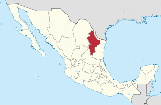
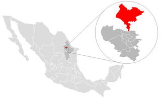
Nuevo León is a state in the northeast region of Mexico. The state was named after the New Kingdom of León, an administrative territory from the Viceroyalty of New Spain, itself was named after the historic Spanish Kingdom of León. With a total land area of 64,555 square kilometers, Nuevo León is the 13th largest federal entity in Mexico. The state is bordered by Tamaulipas to the east, Coahuila to the west, and both Zacatecas and San Luis Potosi to the south. To the north, it shares an international border with the U.S. state of Texas. The Laredo-Colombia Solidarity International Bridge is the only vehicular bridge that connects the United States with the state of Nuevo León. It crosses over the Rio Grande between the city of Colombia, Nuevo León, and Laredo, Texas.

Tamaulipas, officially the Free and Sovereign State of Tamaulipas, is a state in the northeast region of Mexico; one of the 31 states which, along with Mexico City, comprise the 32 Federal Entities of Mexico. It is divided into 43 municipalities.

El Porvenir is a municipio (municipality) and township in the Mexican state of Chiapas.

General Treviño is a municipality in northern Mexico.
Los Ramones is the name of a municipality and its corresponding seat of government and main population center in Mexican state of Nuevo Leon.
Melchor Ocampo is a municipality located in the Mexican state of Nuevo León. It is named after Don Melchor Ocampo, who was Foreign Minister during the government of Benito Juárez.
Cadereyta Jiménez is the name of a city as well as of a municipality in the Mexican state of Nuevo León.

Ciudad Benito Juárez, or simply Juárez, is the name of a city located in the eastern part of the Monterrey metropolitan area in the state of Nuevo León, Mexico. It is the seat of the municipality of the same name. Ciudad Benito Juárez had a 2010 census population of 256,970 persons and is the eighth-largest city in Nuevo León. It shares borders with the municipalities of Pesquería to the north; to the south with Santiago; to the east with Cadereyta Jiménez; and to the west with Guadalupe.

García is a municipality located to the northwest of the Monterrey metropolitan area in the state of Nuevo León, Mexico. García had, according to the 2005 census, a population of 145,867 persons. It borders the municipalities of Mina, Escobedo and Hidalgo to the north; to the south and east with Santa Catarina; and to the west with the state of Coahuila.
Salinas Victoria, is a municipality located to in the center of the state of Nuevo León, Mexico. It shares borders with 11 municipalities including, to the north Villaldama and Sabinas Hidalgo; to the south Escobedo and Apodaca; to the east Higueras, Ciénega de Flores and General Zuazua; and finally to the west with Mina, Hidalgo, Abasolo and El Carmen.

Ciudad Miguel Alemán, known prior to 1950 as San Pedro de Roma, is a city in the Mexican state of Tamaulipas, located across the Rio Grande from the U.S. city of Roma, Texas. The two are linked by the Roma – Ciudad Miguel Alemán International Bridge, a suspension bridge. As of 2010, the population of the city was 19,997. The total population of the surrounding municipality was 27,015.

Mier was a local municipality within the ZF Mgcawu District Municipality in the Northern Cape province of South Africa. Its area includes the South African portion of one of the world's largest conservation areas, the Kgalagadi Transfrontier Park. The main settlement in the municipality is the town of Rietfontein.

Guerrero is a municipality located in the Mexican state of Tamaulipas.

Reynosa is a municipality located in the Mexican state of Tamaulipas. It includes the city of Reynosa. In population, both the municipality and the city (locality) are the largest in their respective categories in the state of Tamaulipas.

Hidalgo is one of the 38 municipalities of Coahuila, in north-eastern Mexico. The municipal seat lies at Hidalgo. The municipality covers an area of 1619.8 km² and is located on the international border between Mexico and the USA, there formed by the Río Bravo del Norte, adjacent to the U.S. state of Texas.
El Carmen, often known as "Carmen", is a town and municipality of the northeastern Mexican state of Nuevo León. The population was 6,996 at the 2005 census. Located in the Salinas Valley region, it is one of the smallest municipalities of the state of Nuevo León, is bordered by the municipalities of Salinas Victoria at North and East, General Escobedo at South, Abasolo and Hidalgo at West. As of 2009, its population is projected to be much higher than it was in the last census, as there is a large number of people moving to this municipality and surrounded municipalities, mainly people from other places outside Nuevo León, because of the lower house prices, compared to that of Monterrey, and the increasing potential of the region due to the relatively close distance to Monterrey, and constant expansion of its metropolitan area, which is estimated to absorb this municipality soon.
Aramberri is a municipality in the northeastern Mexican state of Nuevo León, it is located at southeastern corner of the state. It was founded as Santa María de los Angeles de Río Blanco Mission in 1626 in the jurisdiction of Río Blanco, in the former New Kingdom of León. Its current name honors José Silvestre Aramberri, a general known for his involvement in the Reform War. It borders the municipalities of Galeana and Iturbide to north, Doctor Arroyo to west and southwest, General Zaragoza to south and with state of Tamaulipas to east.
Vallecillo is a municipality located in the state of Nuevo León, in northeastern Mexico.
Doctor Arroyo Municipality is a municipality located in the northeastern Mexican state of Nuevo León. It has a territorial extension of 5,106.2 km2. The municipality was named in honor of José Francisco Arroyo de Anda. The municipality was renamed on September 22, 1826. The municipality had 33,269 inhabitants in the 2010 census.
Mier y Noriega is a municipality situated in the far southern region of the Mexican state of Nuevo León.


