The Maya Lowlands are restricted by the Gulf of Mexico to the north, the Caribbean Sea to the east, and the Maya Highlands to the south and west.[1] The precise northern and eastern limits of the Lowlands are widely agreed upon, being formed by conspicuous bodies of water.[2] Their southern and western limits, however, are not precisely fixed, as these are restricted by 'subtle environmental changes or transitions from one zone [the Highlands] to another [the Lowlands],' rather than conspicuous geographic features.[3][note 4]
The Lowlands are usually subdivided either into northern and southern regions, or into northern, central, and southern regions.[6][7][8][note 6] As with the Lowlands–Highlands border, the boundaries of the Lowlands' internal subdivisions are not precisely fixed, being rather formed by gradual environmental or climatic transitions.[6][note 7]
Northern
The Northern Lowlands are generally characterised by relatively low rainfall and high temperatures, typically ranging within 20–80 inches (510–2,030mm) per annum and 77–95°F (25–35°C), respectively.[9] Their rainy season typically lasts six or seven months during June–December, with a subsequent six- or five-month dry season.[9] Their terrain is predominated by tropical forests in the south, gradually giving way to low bush-and-scrub forests in the north.[9] Prominent bodies of water include Lake Bacalar and various cenotes.[10] Prominent groupings of archaeological sites within the Northern Lowlands include the Northern Plains, the East Coast, the Puuc, and the Chenes sites.[7]
The Northern Lowlands generally encompass portions of Campeche, Yucatán, and Quintana Roo in Mexico.[11][note 8]
Central
The Central Lowlands are generally characterised by relatively low rainfall and high temperatures, typically ranging about 80 inches (2,000mm) per annum and 77–95°F (25–35°C), respectively.[12] Their rainy season typically lasts eight-and-a-half months, from mid-May to January, with a subsequent dry season of three-and-a-half months, from February to mid-May.[12] Their terrain is predominated by low east–west ridges of folded and faulted limestone, covered by tropical forests, grasslands, and wetlands.[12] Prominent bodies of water include the Hondo, New, and Belize Rivers and their tributaries, and a roughly 910 square miles (2,400km2) drainage basin in central Peten housing some fourteen lakes, the largest of which is Lake Peten Itza.[13] Prominent groupings of archaeological sites within the Central Lowlands include the Belize River Valley and the Central Peten Lakes.[14]
The Southern Lowlands are generally characterised by relatively high rainfall and temperatures, typically ranging within 80–120 inches (2,000–3,000mm) per annum and 77–95°F (25–35°C), respectively.[16][17] Their rainy season ranges between nine and eleven months, with the dry season compressed to three months or fewer, with the latter typically occurring during March–May.[16][note 10] Their terrain ranges from broken karst topography, predominated by rain-forest and limestone formations, to low-lying coastal topography, predominated by swamps.[16][17] Prominent bodies of water within the Southern Lowlands, which often feature relatively deep and fertile soils, include the Usumacinta River and its tributaries, the Sarstoon River, Lake Izabal, the Rio Dulce, the alluvial valley of the lower Motagua, and the Chamelecon and Ulua Rivers.[18][17] Prominent groupings of archaeological sites within the Southern Lowlands include the Southern Belize Region.[19]
The Lowlands are generally characterised by elevations below 1,000–2,625 feet (305–800m) and a hot, tropical climate.[21][22][note 12] They are predominantly covered by evergreen tropical forests, which tend to grow taller and denser in the southern Lowlands, given increased rainfall in this area, compared to the northern Lowlands, which experience relatively less rainfall.[21][23] The climate of the eastern coasts is made relatively warmer and more humid by the Atlantic North Equatorial Current and the Gulf Stream.[24]
Human
The Lowlands have been deemed the 'most central [subdivision of the Maya Region] to the story of Maya civilisation,' with tentative estimates placing the region's population in circa AD 800 at 2–10 million, and 17 of the largest 19 ancient Maya cities located in the region.[25][26][note 13]
Climate
The Lowlands are characterised by a hot, tropical climate, and are thus traditionally known as tierra caliente, 'hot country,' in Spanish.[27][28] The area experiences two seasons, wet and dry ones, with rainfall during the wet season usually peaking in June and October.[29] Mean annual rainfall typically ranges within 20–120 inches (510–3,050mm), with temperatures typically within 77–95°F (25–35°C).
Scholars have traditionally assumed that the Lowlands' present-day climate had 'always been the same, all through Maya prehistory and history,' but palaeoclimatic research has 'challenged this assumption, revealing far more climatic fluctuation than previously anticipated.'[30][31] In particular, climate proxies from Quintana Rooan lakes and Belizean caves have provided 'a continuous record of climate changes for the Maya Lowlands extending over a period of 3,500 years.'[30] These have revealed, for instance, particularly severe or prolonged droughts during AD 200–300, 420, 820–870, 930, and 1020–1100, some of which are thought to have played a part in the collapse of various ancient cities.[32]
Geology
Morphology
Provinces
The Lowlands are thought to fully or partially encompass at least eleven geologic provinces.[33][34][note 14] Notably, the northern and central Lowlands 'encompass the most extensive karstlands of the North American continent' i.e. the Yucatán Platform.[35]
Geologic provinces within the Maya Lowlands per 21st century literature.[33][34][note 15]
USGS No.
Name
Location
Notes
5308
Yucatán Platform
northern Lowlands
–
6117
Greater Antilles Deformed Belt
offshore Lowlands
–
6120
Cayman Trough
southern Lowlands
–
6125
Maya Mountains
central Lowlands
–
5305
Villahermosa Uplift
western Lowlands
–
5306
Macuspana Basin
western Lowlands
–
5304
Saline–Comalcalco Basin
western Lowlands
–
5302
Veracruz Basin
western Lowlands
–
5303
Tuxla Uplift
western Lowlands
–
5311
Chiapas Massif
western Lowlands
–
5310
Sierra Madre de Chiapas–Peten Foldbelt
southern Lowlands
–
Basins
The Lowlands are believed to fully or partially comprehend at least four sedimentary basins.[36]
Sedimentary basins within the Maya Lowlands per 21st century literature.[36][note 16]
Evenick ID
Name
Location
Notes
119
Campeche
northern Lowlands
–
519
Peten–Corozal
central Lowlands
–
757
Yucatán
northern Lowlands
–
647
Sureste
western Lowlands
–
Tectonics
The Lowlands lie wholly within the Maya Block of the North American Plate.[37][38][39] They notably house the Ticul Fault to the north, the Rio Hondo, Yucatán Channel, and Maya Mountain Faults to the east, and a portion of the Motagua–Polochic Fault Zone to the south.[40]
Stratigraphy
In the northern and central Lowlands, encompassed within the Yucatán Platform, mean crustal thickness increases from 12–16 miles (20–25km) in the north to 19–25 miles (30–40km) in the south.[41] These portions of the Lowlands are blanketed by a carbonate sedimentary cover reaching a mean thickness of up to some 4 miles (6km).[41]
↑ As per Sharer & Traxler 2006, p.24 within 10mi (16km) accuracy. Adams & Macleod 2000b, p.346 give length and width as 'more than' 404mi (650km) and 'about' 280mi (450km), respectively. Wallace 2020, p.17 gives length and width as about 447mi (719km) and about 388mi (624km), respectively.
↑ The three commonly-given first-order sub-divisions of the Maya Region being, from north to south, the Lowlands, Highlands, and Pacific Coastal Plain (Sharer & Traxler 2006, pp.24, 30). However, Adams & Macleod 2000a, p.200 assert that the Maya Region 'has traditionally been divided into three major physical zones: the northern lowlands, southern lowlands, and highlands (including the Pacific slope); or in some schemes, northern, central and southern regions.'
↑ The transition from the Maya Highlands to the Lowlands has been described as 'gradual' (Sharer & Traxler 2006, p.41). Rough demarcations are nonetheless attempted in literature. For instance, Wallace 2020, p.16 fixes the southern and western limits as being just above (or on the foothills of) 'the volcanic mountain ranges of Guatemala and Chiapas.' Adams & Macleod 2000b, p.346 fix them as a line (i) encompassing Cholan Mayan speakers (ii) running from eastern Tabasco, through eastern Chiapas, into Alta Verapaz, and up to northwestern Honduras.
↑ For instance, the Lowlands as characterised by Adams & Macleod 2000b, p.346 encompass 'eastern Tabasco, the lowland tropical forests of eastern Chiapas, [...] parts of Alta Verapaz, Guatemala, and [part of] northwestern Honduras.'
↑ Some literature gives the Northern and Southern Lowlands as first order, rather than second order subdivisions of the Maya Region (Adams & Macleod 2000a, p.200).
↑ Rough demarcations are nonetheless attempted in literature. For instance, Wallace 2020, p.16 (using only two internal subdivisions) fixes the North–South border as 'a roughly straight line between the Bay of Chetumal in the east and the Laguna de Terminos in the west.' Adams & Macleod 2000b, p.352 (using the same sub-divisions) fix it as 'a line drawn from Champotón (formerly Chanputun) on the Gulf [of Mexico] Coast to the Bahía de la Ascención on the Caribbean [Sea].'
↑ In literature which only sub-divides the Maya Lowlands into northern and southern portions, omitting a central portion, the Northern Lowlands may further encompass portions of Peten in Guatemala, Campeche and Quintana Roo in Mexico, and Cayo, Belize [District], Orange Walk, and Corozal in Belize (eg as in Carrasco 2006, article 'Northern Maya Lowlands' para. 1).
↑ Some literature only sub-divides the Maya Lowlands into northern and southern portions, omitting a central portion (eg as in Carrasco 2006, article 'Mesoamerica' para. 6). Furthermore, some literature rather characterises the Central Lowlands as encompassing 'most of the Petén, Belize, and usually the Río Bec region of southern Campeche' (Carrasco 2006, article 'Northern Maya Lowlands' para. 1).
↑ Carrasco 2006, article 'Southern Maya Lowlands' para. 3 give the Southern Lowlands' wet season as occurring during late-May–November, implying a December–mid-May dry season, in contrast to the March–May dry season asserted by Sharer & Traxler 2006, p.45. However, the extent of the Southern Lowlands as given by Carrasco 2006, article 'Southern Maya Lowlands' para. 1 differs from that given by Sharer & Traxler 2006, p.24.
↑ In literature which only sub-divides the Maya Lowlands into northern and southern portions, omitting a central portion, the Southern Lowlands may further encompass portions of Peten in Guatemala, Campeche and Quintana Roo in Mexico, and Cayo, Belize [District], Orange Walk, and Corozal in Belize (eg as in Carrasco 2006, article 'Southern Maya Lowlands' para. 1 and Carrasco 2006, article 'Northern Maya Lowlands' para. 1).
↑ As opposed to a generally temperate or cold climate experienced in elevations above 2,625 feet (800m) in the rest of the Maya Region (Sharer & Traxler 2006, p.30). The Maya Mountains, commonly included within the Lowlands, nonetheless feature elevations above 2,625 feet (800m) (Sharer & Traxler 2006, p.46, Carrasco 2006, article 'Southern Maya Lowlands' para. 1).
Bundschuh, Jochen; Alvarado, Guillermo E., eds. (2012) [2007]. Central America: Geology, Resources and Hazards (Reprint of 1sted.). London: Taylor & Francis. doi:10.1201/9780203947043. ISBN9780429074370. OCLC905983675.
Coe, Michael D.; Houston, Stephen D. (2015) [1966]. The Maya (9thed.). New York: Thames & Hudson. OCLC915597000.
Demarest, Arthur A., ed. (2007) [2004]. Ancient Maya: The rise and fall of a rainforest civilization. Case Studies in Early Societies (Reprint of 1sted.). Cambridge: Cambridge University Press. OCLC717693582. OL3440009M.
Gómez-Pompa, Arturo; Allen, Michael F.; Fedick, Scott L.; Jiménez-Osornio, Juan J., eds. (2003). The Lowland Maya Area: Three Millennia at the Human-Wildland Interface. Binghamton, NY: Food Products Press. ISBN1560229705. OCLC50725221.
Nairn, Alan E. M.; Stehli, Francis G., eds. (1975). The Gulf of Mexico and the Caribbean. The Ocean Basins and Margins. Vol.3. New York: Springer. doi:10.1007/978-1-4684-8535-6. ISBN978-1-4684-8537-0.
Pohl, Mary DeLand, ed. (1990). Ancient Maya wetland agriculture: excavations on Albion Island, Northern Belize. Westview special studies in archaeological research. Boulder, CO: Westview Press. hdl:2027/txu.059173017866398. ISBN081337202X. OCLC15421978.
Sharer, Robert J.; Traxler, Loa P., eds. (2006) [1946]. The Ancient Maya (6thed.). Stanford, Calif.: Stanford University Press. hdl:2027/mdp.39015062626216. OCLC57577446.
UISPP, ed. (2020). Different Times?: Archaeological and environmental data from intra-site and off-site sequences: proceedings of the XVIII UISPP World Congress (4-9 June 2018, Paris, France): Volume 4, Session II-8. Archaeopress archaeology. Oxford: Archaeopress Publishing. ISBN9781789696516. OCLC1154813259.
Woods, Charles A.; Sergile, Florence E., eds. (2001) [First published 1989 in Gainesville, FL by Sandhill Crane Press]. Biogeography of the West Indies: patterns and perspectives (2nd reviseded.). Boca Raton, FL: CRC Press. ISBN0849320011. OCLC46240352.
Brenner, Mark (6 July 2022). "Classics revisited/from the archive Mayan Urbanism: Impact on a Tropical Karst Environment". Progress in Physical Geography: Earth and Environment. doi:10.1177/03091333221112360. S2CID24238716.
French, C. D.; Schenk, C. J. (2004). "Map showing geology, oil and gas fields, and geologic provinces of the Caribbean Region". Open-File Report (Report). Open-File Report 97-470-K. Reston, Virg.: U.S. Geological Survey. doi:10.3133/ofr97470K.
French, C. D.; Schenk, C. J. (2006). "Map showing geology, oil and gas fields, and geologic provinces of the Gulf of Mexico region". In French, Christopher D; Schenk, Christopher J (eds.). Open-File Report (Report). Open-File Report 97-470-L. Reston, Virg.: U.S. Geological Survey. doi:10.3133/ofr97470L.
Kirst, K. Kris (14 December 2019). "Maya Lowlands". ThoughtCo. Archived from the original on 9 September 2022.
Witschey, Walter R. T.; Brown, Clifford T. (2010). "Maps of the Maya Area". Electronic Atlas of Ancient Maya Sites. Archived from the original on 20 June 2010.
Related Research Articles
The Spanish conquest of Yucatán was the campaign undertaken by the Spanish conquistadores against the Late Postclassic Maya states and polities in the Yucatán Peninsula, a vast limestone plain covering south-eastern Mexico, northern Guatemala, and all of Belize. The Spanish conquest of the Yucatán Peninsula was hindered by its politically fragmented state. The Spanish engaged in a strategy of concentrating native populations in newly founded colonial towns. Native resistance to the new nucleated settlements took the form of the flight into inaccessible regions such as the forest or joining neighbouring Maya groups that had not yet submitted to the Spanish. Among the Maya, ambush was a favoured tactic. Spanish weaponry included broadswords, rapiers, lances, pikes, halberds, crossbows, matchlocks, and light artillery. Maya warriors fought with flint-tipped spears, bows and arrows and stones, and wore padded cotton armour to protect themselves. The Spanish introduced a number of Old World diseases previously unknown in the Americas, initiating devastating plagues that swept through the native populations.
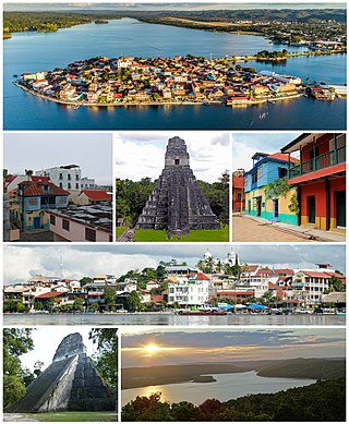
Petén is a department of Guatemala. It is geographically the northernmost department of Guatemala, as well as the largest by area – at 35,854 km2 (13,843 sq mi) it accounts for about one third of Guatemala's area. The capital is Flores. The population at the mid-2018 official estimate was 595,548.
The Maya Mountains are a mountain range located in Belize and eastern Guatemala, in Central America.
The Petén Basin is a geographical subregion of the Maya Lowlands, primarily located in northern Guatemala within the Department of El Petén, and into the state of Campeche in southeastern Mexico.
Río Azul is an archaeological site of the Pre-Columbian Maya civilization. It is the most important site in the Río Azul National Park in the Petén Department of northern Guatemala, close to the borders of Mexico and Belize. Río Azul is situated to the southeast of the Azul river and its apogee dates to the Early Classic period.
Kinal is a major pre-Columbian Maya archaeological site in the Petén Department of the modern-day Petén Department of northern Guatemala. The major occupational phase for the site dates from the Late Classic period of Mesoamerican chronology, with evidence for a substantial and expansionary building program dating from the first half of the 8th century AD. Kinal was discovered in the 1960s by archaeologist Ian Graham while he was carrying out an archaeological survey of the region, although no excavations were undertaken at the site at that time.
The Petén–Veracruz moist forests is an ecoregion of the tropical and subtropical moist broadleaf forest biome found in Belize, Guatemala, and Mexico.
The Maya civilization was a Mesoamerican civilization that existed from antiquity to the early modern period. It is known by its ancient temples and glyphs (script). The Maya script is the most sophisticated and highly developed writing system in the pre-Columbian Americas. The civilization is also noted for its art, architecture, mathematics, calendar, and astronomical system.
The Spanish conquest of the Maya was a protracted conflict during the Spanish colonisation of the Americas, in which the Spanish conquistadores and their allies gradually incorporated the territory of the Late Postclassic Maya states and polities into the colonial Viceroyalty of New Spain. The Maya occupied the Maya Region, an area that is now part of the modern countries of Mexico, Guatemala, Belize, Honduras and El Salvador; the conquest began in the early 16th century and is generally considered to have ended in 1697.
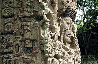
Maya stelae are monuments that were fashioned by the Maya civilization of ancient Mesoamerica. They consist of tall, sculpted stone shafts and are often associated with low circular stones referred to as altars, although their actual function is uncertain. Many stelae were sculpted in low relief, although plain monuments are found throughout the Maya region. The sculpting of these monuments spread throughout the Maya area during the Classic Period, and these pairings of sculpted stelae and circular altars are considered a hallmark of Classic Maya civilization. The earliest dated stela to have been found in situ in the Maya lowlands was recovered from the great city of Tikal in Guatemala. During the Classic Period almost every Maya kingdom in the southern lowlands raised stelae in its ceremonial centre.
Maya cities were the centres of population of the pre-Columbian Maya civilization of Mesoamerica. They served the specialised roles of administration, commerce, manufacturing and religion that characterised ancient cities worldwide. Maya cities tended to be more dispersed than cities in other societies, even within Mesoamerica, as a result of adaptation to a lowland tropical environment that allowed food production amidst areas dedicated to other activities. They lacked the grid plans of the highland cities of central Mexico, such as Teotihuacán and Tenochtitlan. Maya kings ruled their kingdoms from palaces that were situated within the centre of their cities. Cities tended to be located in places that controlled trade routes or that could supply essential products. This allowed the elites that controlled trade to increase their wealth and status. Such cities were able to construct temples for public ceremonies, thus attracting further inhabitants to the city. Those cities that had favourable conditions for food production, combined with access to trade routes, were likely to develop into the capital cities of early Maya states.
The Yucatecan languages form a branch of the Mayan family of languages, comprising four languages, namely, Itzaj, Lacandon, Mopan, and Yucatec. The languages are presently extant in the Yucatán Peninsula, encompassing Belize, northern Guatemala, and southeastern Mexico.
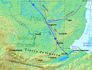
The Spanish conquest of Petén was the last stage of the conquest of Guatemala, a prolonged conflict during the Spanish colonisation of the Americas. A wide lowland plain covered with dense rainforest, Petén contains a central drainage basin with a series of lakes and areas of savannah. It is crossed by several ranges of low karstic hills and rises to the south as it nears the Guatemalan Highlands. The conquest of Petén, a region now incorporated into the modern republic of Guatemala, climaxed in 1697 with the capture of Nojpetén, the island capital of the Itza kingdom, by Martín de Ursúa y Arizmendi. With the defeat of the Itza, the last independent and unconquered native kingdom in the Americas fell to European colonisers.
The Manche Chʼol were a Maya people who constituted the former Manche Chʼol Territory, a Postclassic polity of the southern Maya Lowlands, within the extreme south of what is now Petén and the area around Lake Izabal in northern Guatemala, and southern Belize. The Manche Chʼol took the name Manche from the name of their main settlement. They were the last of a set of Ch'olan-speaking groups in the eastern Maya Lowlands to remain independent and ethnically distinct. It is likely that they were descended from the inhabitants of Classic period Maya cities in the southeastern Maya Lowlands, such as Nim Li Punit, Copán and Quiriguá.
The history of Maya civilization is divided into three principal periods: the Preclassic, Classic and Postclassic periods; these were preceded by the Archaic Period, which saw the first settled villages and early developments in agriculture. Modern scholars regard these periods as arbitrary divisions of chronology of the Maya civilization, rather than indicative of cultural evolution or decadence. Definitions of the start and end dates of period spans can vary by as much as a century, depending on the author. The Preclassic lasted from approximately 3000 BC to approximately 250 AD; this was followed by the Classic, from 250 AD to roughly 950 AD, then by the Postclassic, from 950 AD to the middle of the 16th century. Each period is further subdivided:
The Maya Block, also known as the Maya Terrane, Yucatan Block, or Yucatan–Chiapas Block, is a physiographic or geomorphic region and tectonic or crustal block in the southernmost portion of the North American Plate.
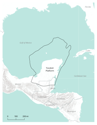
The Yucatán Platform or Yucatán Shelf is a geologic or physiographic province, and a continental and carbonate platform, in the Maya Block of the southernmost portion of the North American Plate. It comprises the Yucatán Peninsula and its continental shelf, located between the Gulf of Mexico and the Caribbean Sea.
The Preclassic or Formative Period of Belizean, Maya, and Mesoamerican history began with the Maya development of ceramics during 2000 BC – 900 BC, and ended with the advent of Mayan monumental inscriptions in 250 AD.
The Maya Region is cultural, first order subdivision of Mesoamerica, located in the eastern half of the latter. Though first settled by Palaeoindians by at least 10,000 BC, it is now most commonly characterised and recognised as the territory which encompassed the Maya civilisation in the pre-Columbian era.
This page is based on this Wikipedia article Text is available under the CC BY-SA 4.0 license; additional terms may apply. Images, videos and audio are available under their respective licenses.