Related Research Articles
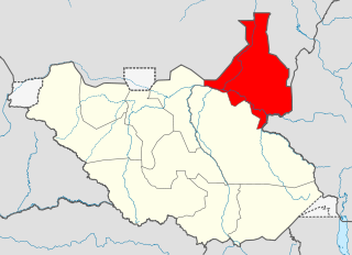
Upper Nile is a state in South Sudan. The White Nile flowes through the state, giving it its name. The state also shares a similar name with the region of Greater Upper Nile, of which it was part along with the states of Unity and Jonglei. It had an area of 77,823 square kilometres (30,048 sq mi). Malakal was the capital of the state. The towns of Upper Nile State Benythieng Akoka, Maluth, Renk, Kodok, the location of the Fashoda Incident that ended the "Scramble for Africa", was located in the state. Upper Nile seceded from Sudan as part of the Republic of South Sudan on 9 July 2011.
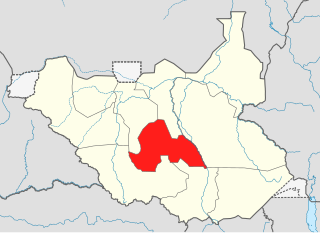
Lakes State is a state in South Sudan. It has an area of 43,595.08 km2. Rumbek is the capital of the state. Lakes is in the Bahr el Ghazal region of South Sudan, in addition to Northern Bahr el Ghazal, Western Bahr el Ghazal, and Warrap states. Bahr el Ghazal itself was a former province which was split from the Anglo-Egyptian mudiriyat, or province of Equatoria in 1948. The eastern border was the White Nile with Jonglei State on the opposite bank. To the northeast lied the Unity State. Other borders included Warrap State towards the northwest, Western Equatoria to the south and west, and Central Equatoria to the south.
Unity State, also known as Western Upper Nile, is a state in South Sudan. Unity State is in the Greater Upper Nile region. Unity is inhabited predominantly by two ethnic groups: the Nuer majority, and the Dinka minority.

Northern Bahr el Ghazal(Arabic: ولاية شمال بحر الغزال) is a state in South Sudan. It has an area of 30,543 km2 and is part of the Bahr el Ghazal region. It borders East Darfur in Sudan to the north, Western Bahr el Ghazal to the west and south, and Warrap and the disputed region of Abyei to the east. Aweil is the capital of the state.

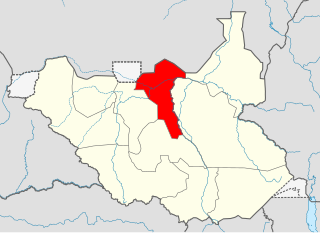
Warrap is one of the ten states in South Sudan, located in the Bahr el Ghazal region. The state became part of South Sudan after a successful secession from Sudan on 9 July 2011. Wanhalel, the place where first Jieng Customary Laws were initiated and hometown to prominent politician, Gen. Nhial Deng Nhial is located in Tonj South County of Warrap State The current governor is Kuol Muor Muor who replaced Manhiem Bol Malek in November, 2023.
The Nuer language (Thok Naath) ("people's language") is a Nilotic language of the Western Nilotic group. It is spoken by the Nuer people of South Sudan and in western Ethiopia (region of Gambela). The language is very similar to Dinka and Atuot.

Bentiu, also spelled Bantiu, is a city in South Sudan and capital of the state of Unity State.

The flag of South Sudan was adopted following the signing of the Comprehensive Peace Agreement that ended the Second Sudanese Civil War. A different version of the flag was previously used as the flag of the Sudan People's Liberation Movement. The flag of South Sudan predates the country, as the flag was adopted in 2005, while the country became independent in 2011.

The States of South Sudan were created out of the three historic former provinces of Bahr el Ghazal (northwest), Equatoria (southern), and Greater Upper Nile (northeast). The states are further divided into 79 counties.
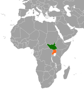
South Sudan and Uganda are neighboring states with strong cultural economic and political ties. The South Sudan and the neighbouring state of Uganda enjoy relatively strong cultural, political, and economic ties. As South Sudan neared independence, both states begun to take advantage of increased opportunities for trade, development and educational exchanges. The rebel group Lord's Resistance Army (LRA), however, continues to operate in the border areas between South Sudan, the Democratic Republic of Congo and Uganda.
South Sudan, officially the Republic of South Sudan, is a landlocked country in eastern Central Africa. It is bordered by Ethiopia, Sudan, the Central African Republic, the Democratic Republic of the Congo, Uganda, and Kenya, and includes the vast swamp region of the Sudd, formed by the White Nile and known locally as the Bahr al Jabal, meaning "Mountain Sea". The population was 11,088,796 in 2023, and Juba is the capital and largest city. South Sudan gained independence from Sudan on 9 July 2011, making it the most recent sovereign state or country with widespread recognition as of 2024.
Leer County is an administrative division of Western Upper Nile in South Sudan. The headquarters is in the town of Leer.

Fangak County is an administrative area in Jonglei State, South Sudan, with headquarters in the town of Phom el Zaraf.
Mayom County is an administrative region in Unity of South Sudan to the west of Bentiu. The county headquarters is Mayom town.
Koch County is an administrative division of Unity State, South Sudan, covering an area in the center of the state.
Abiemnom County is an administrative area in the extreme northwest of Ruweng Administrative Area, South Sudan. It borders Southern Kordofan in Sudan to the north.
Rubkona County is an administrative division of Unity State, South Sudan.

The Ruweng Administrative Area is an administrative area in South Sudan. The area was known as Ruweng State between 2 October 2015 and 22 February 2020 when it was a state of South Sudan.
Guit County is a county located in Unity State, South Sudan, which has been impacted by the South Sudanese Civil War.
This article lists events from the year 2020 in South Sudan
References
- ↑ "South Sudan: States and counties". www.citypopulation.de. Retrieved 14 February 2024.
| | This South Sudan location article is a stub. You can help Wikipedia by expanding it. |