Richland Township is one of the seventeen townships of Logan County, Ohio, United States. As of the 2010 census, the population was 2,482.
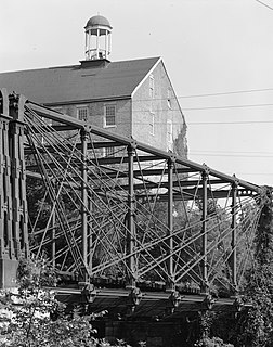
The Bollman Truss Railroad Bridge at Savage, Maryland is the sole surviving example of a revolutionary design in the history of American bridge engineering. The 160-foot (48.8 m) double-span is a suspension truss bridge. The first Bollman bridge was installed on the site; however, the current bridge is not the original. The current bridge was built in 1852 and moved to the site thirty years later. It is one of the oldest standing iron railroad bridges in the United States. Currently, however, it is in use carrying the Savage Mill Trail across the Little Patuxent River.

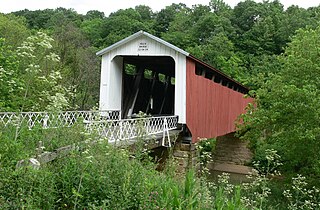
Harpersfield Bridge is a covered bridge spanning the Grand River in Harpersfield Township, Ashtabula County, Ohio, United States. This double-span Howe truss bridge, one of currently 17 drivable covered bridges in the county, is the third longest covered bridge in Ohio at 228 feet. A flood in 1913 washed away the land at the north end of the bridge, and the steel span was subsequently attached. The bridge features a walkway, added during its renovation in 1991–1992. The bridge also features an Ashtabula County MetroPark at its north end, and is listed on the National Register of Historic Places. The bridge's WGCB number is 35-04-19, and it is located approximately 3.4 miles south of Geneva.

The Tioronda Bridge once carried South Avenue in Beacon, New York, across Fishkill Creek. Built between 1869 and 1873 by the Ohio Bridge Company, it was demolished by the city in December 2006. The bridge had been listed on the National Register of Historic Places in 1976, but a decade later had deteriorated to the point that it had to be closed.

The Belknap Bridge crosses the McKenzie River near the unincorporated community of Rainbow in Lane County, Oregon, United States. It is approximately three miles west of the town of McKenzie Bridge which is named after the bridge. It is the fourth covered bridge built on the site. The bridge is well maintained and open to traffic. The Belknap Bridge is listed on the National Register of Historic Places.

The Goodpasture Bridge spans the McKenzie River near the community of Vida in Lane County, Oregon, United States. It is the second longest covered bridge and one of the most photographed covered bridges in the state. The Goodpasture Bridge is listed on the National Register of Historic Places.
The Waterford Covered Bridge is a Town lattice truss covered bridge spanning LeBoeuf Creek in Waterford Township, Erie County in the U.S. state of Pennsylvania. The bridge was built in 1875, and is 85 feet 11 inches (26.2 m) in length. The Waterford Covered Bridge is one of two remaining covered bridges in Erie County, along with the Harrington Covered Bridge. The bridge is also the only Town lattice truss bridge in the county and one of only 19 in Pennsylvania. It was documented by the Historic American Buildings Survey in 1936 and was listed on the National Register of Historic Places in 1980. In 2011, the bridge was closed due to its deteriorating condition.

The Medora Covered Bridge is the longest covered bridge in the United states with the entire original historic truss still in place with some repairs but no structural changes. Measuring the clear span of 431'10", the Medora Covered Bridge is the longest historic covered bridge in the United States. The roof length of 461' and the siding at the floor length of 459' are also the longest historic covered bridge measurements in the U.S..
The Bath Covered Bridge is a historic covered bridge over the Ammonoosuc River off US 302 and NH 10 in Bath, New Hampshire. Built in 1832, it is one of the state's oldest surviving covered bridges. It was listed on the National Register of Historic Places in 1976, and underwent a major rehabilitation in the 2010s.

The Lockington Covered Bridge was a historic covered bridge that once spanned the Great Miami River near Lockington, Ohio, United States. Built in 1848, it employed the Long Truss method of construction. Construction elements included vertical wooden siding, wooden structural elements, wooden shingles on its roof, and cut stone abutments. Measuring approximately 170 feet (52 m) long, the bridge was composed of two spans; it cost $1,500 to build.
The Hildreth Covered Bridge, also known as the "Hills Covered Bridge" or "Lafaber's Mill Bridge," is a historic covered bridge in Washington County, Ohio, United States. Located off State Route 26 in Newport Township, about 5 miles (8.0 km) east of the city of Marietta, the bridge historically carried Hills Bridge Road over the Little Muskingum River. Construction of the Hildreth Bridge was a long process: the most significant amount of work was done on the bridge in 1878, but the entire construction process occurred between 1871 and 1881. The identity of its builder is unknown.
The Root Covered Bridge is a historic wooden covered bridge in the southeastern part of the U.S. state of Ohio. Located off State Route 555 in far northern Decatur Township, Washington County, the bridge was built in 1878 in the Long truss mode of truss bridge construction. Measuring 65 feet (20 m) in its single span, it spans the West Branch of the Little Hocking River.

The Great Eddy Covered Bridge, also called the Big Eddy Covered Bridge or Waitsfield Covered Bridge, is a wooden covered bridge that crosses the Mad River in Waitsfield, Vermont on Bridge Street. Built in 1833, it is one of Vermont's oldest covered bridges. It was listed on the National Register of Historic Places in 1974.

The Second Street Bridge is a one-lane, single-span truss bridge in Allegan, in the U.S. state of Michigan, that carries Second Street over the Kalamazoo River. It is a Michigan State Historic Site, a National Historic Civil Engineering Landmark, and is listed on the National Register of Historic Places. Built in 1886, the bridge replaced an earlier wooden structure. In the early 1980s, the bridge underwent significant renovation.

The Stonelick Covered Bridge is located on Stonelick-Williams Corner Road in Clermont County, Ohio, crossing the Stonelick Creek. The one-lane covered bridge was built in 1878. It is 140 feet long and supported using a 12-panel Howe truss. The property was added to the National Register on September 10, 1974, being the last surviving covered bridge in Clermont County.
The Ponn Humpback Covered Bridge was a historic covered bridge in the southeastern part of the U.S. state of Ohio. Located near the village of Wilkesville in Vinton County, it bore a name derived from its unusual shape: the bridge was arched in the middle, rather than being flat like a typical covered bridge. Declared a historic site in the 1970s, the bridge had a history closely tied to arson — it was constructed to replace a bridge that had been burned intentionally, and it met its end at the hands of an arsonist.
Scott Covered Bridge is a covered bridge spanning the West River in Townshend, Vermont. Built in 1870, it is at 277 feet (84 m) one of the longest covered bridges in the state, exhibiting three different forms of support: a Town lattice truss, kingpost trusses, and laminated arches. The bridge was listed on the National Register of Historic Places in 1973. It is closed to all traffic.

The Wimer Bridge is a covered bridge over Evans Creek in Jackson County in the U.S. state of Oregon. The version that was listed on the National Register of Historic Places, was built in 1927. This structure, 85 feet (26 m) long, carried East Evans Creek County Road over the creek in the rural community of Wimer. The creek is a tributary of the Rogue River, which it joins at the small city of Rogue River.

The Lincoln Covered Bridge is a historic covered bridge, just south of U.S. Route 4 in West Woodstock, Vermont. Built in 1877, it is one of the only known examples of a wooden Pratt truss bridge in the United States. It was listed on the National Register of Historic Places in 1973.