Meades Ranch Triangulation Station

Last updated
Geodetic Center of the U.S.
Meade Ranch triangulation station ca. 1940.jpg
Meades Ranch triangulation station, ca. 1940
USA Kansas location map.svg
Red pog.svg
Location of Meades Ranch in Kansas
Nearest city Osborne, Kansas
Coordinates 39°13′27″N98°32′32″W / 39.224087°N 98.542152°W / 39.224087; -98.542152
Built1891 (1891)
NRHP reference No. 73000772 [1]
Added to NRHPOctober 9, 1973

The Meades Ranch Triangulation Station is a survey marker in Osborne County [2] in the state of Kansas in the Midwestern United States. The marker was initially placed in 1891. From 1901, it was the reference location for establishing a system of horizontal measurement in the United States, known as geodetic datum. In 1913, the datum was adopted across all of North America, and the system revised and formalized as the North American Datum of 1927 (NAD27). A similar reference for vertical measurement was established in 1929 as the National Geodetic Vertical Datum of 1929. The NAD27 was later supplanted by the North American Datum of 1983 (NAD83), which was formally adopted by the United States in 1989 and Canada in 1990; the new system moved the reference point to a point in the Earth's core, and the Meades Ranch marker lost its special significance to the geodetic datum system.

Contents

In 1973, the site was listed in the National Register of Historic Places as the Geodetic Center of the United States.

History

In surveying, a geodetic datum is a point or set of points used to establish a coordinate system. By designating the location of one point, and the direction from that point to a second point, one can establish a system relative to which other points can be located and mapped. As one surveys a larger area over which the curvature of the Earth becomes significant, it also becomes necessary to define an ellipsoid: a curved surface that approximates the shape of the Earth in the area of interest. [3] [4]

The first nationwide datum in the United States was established in 1879. At that time, a region of contiguous triangulation existed from Maine to Georgia. The New England Datum was chosen with a benchmark in Maryland, near the middle of this region, as the horizontal datum, and a second Maryland mark used to define the azimuth (horizontal) direction. [5] To account for the Earth's curvature, the datum used a model called the Clarke spheroid, developed in 1866. [6]

Meades Ranch station

The United States Coast and Geodetic Survey established a triangulation station, officially known as the Meades Ranch Triangulation Station, in 1891. The location lay near the intersection of two transcontinental arcs of triangulation: one running from the Atlantic to the Pacific Ocean, roughly following the 39th parallel; the other running from Mexico to Canada, along the 98th meridian. [2] [7] [8]

In 1901, the Meades Ranch station was chosen as the United States standard horizontal datum: the point relative to which all land measurements in the nation were made. The choice was based on the station's location near the geographic center of the U.S. and near the intersection of the two arcs of triangulation, and because it minimized the number of changes in previously published positions. Its position was officially set as 39°13'26.686" N and 98°32'30.506" W; the azimuth direction to a triangulation station near Waldo, southwest of Meades Ranch, was officially set as 75°28'14.52" west of south. [2] [5] [7]

In 1913, the chief astronomer of the Dominion of Canada Astronomical Observatory and the director of the Comisión Geodésica Mexicana announced that their organizations would use the Meades Ranch location as their standard datum. In light of this, its name was changed to the "North American Datum". [7]

Horizontal survey control network in the United States in 1931 Horizontal Control Network of the United States June 1931.jpg
Horizontal survey control network in the United States in 1931

As more new surveys and previously isolated survey networks were incorporated into the system, it became increasingly difficult to make the necessary corrections. By the mid-1920s, it was realized that the coordinate system needed to be adjusted. From 1927 to 1932, the approximately 25,000 existing control locations were recalculated and a new coordinate system developed, known as NAD27. The new system continued to use the 1901 coordinates of Meades Ranch as its horizontal datum, and the Clarke spheroid as its model for the Earth's surface. However, it now defined horizontal directions in terms of 175 Laplace azimuths, which use astronomical azimuths corrected for the difference between the astronomic and geodetic meridians. Under NAD27, the azimuth to the Waldo station changed by about 5". [4] [5] [6] [9] [10]

In 1973, the Meades Ranch site was added to the National Register of Historic Places, under the name "Geodetic Center of the United States". [11]

NAD83

Following the establishment of NAD27, it was noted that it produced a discrepancy of about 10 meters (33 ft) in latitudes in the northern part of the northern U.S. state of Michigan, necessitating a regional adjustment for the states of Michigan and Wisconsin. As the survey network was extended further north into Canada, similar discrepancies appeared. The problem proved to be systemic: It had been assumed that the differences between the Clarke spheroid and the actual geoid were negligible, whereas these differences actually introduced significant errors. The relatively small number and large separation of the points used to develop NAD27, the limited computational power available to its designers, and the movement of tectonic plates also led to inconsistencies in NAD27 coordinates. [6] [12]

[[File:Datum Shift Between NAD27 and NAD83.png|thumb|alt=Map of lower-48 states, color-coded to indicate differences; an area around Indiana is at zero; the east coast is generally between {{convert|20|and|50|m|sp=us; Washington, Oregon, western Nevada, and most of California are between {{convert|80|and|100|m|sp=us|Changes in horizontal location between NAD27 and NAD83]]

To address these, a new datum was developed, designated NAD83. It replaced the Clarke spheroid with a new ellipsoid, the Geographic Reference System 1980, centered at the Earth's center of mass as determined by the Bureau International de l'Heure. The new datum was based on adjustment of 250,000 points, including 600 satellite Doppler stations. NAD83 was officially adopted by the U.S. government in 1989, and by the Canadian government in 1990. Under the new system, Meades Ranch lost its special standing, and became one of thousands of stations. [10] [13] [14] [15]

Description

Marker at Osborne rest area, incorporating replica of Meades Ranch station marker disc North America geodetic center - replica plaque 1.JPG
Marker at Osborne rest area, incorporating replica of Meades Ranch station marker disc

As of 2012, the location of the Meades Ranch station was 39°13′26.71220″N98°32′31.74540″W / 39.2240867222°N 98.5421515000°W / 39.2240867222; -98.5421515000 (in NAD83(2011); WGS 84 location may be very slightly off). It lies about 12 miles (19 km) north of Lucas and about 10 miles (16 km) southwest of Tipton. [16]

The station is on a low grassy ridge in a pasture. It is marked by a bronze disc, inscribed "Meades Ranch 1891", embedded in the top of a dome-shaped concrete marker 21 inches (53 cm) in diameter, rising about 4 inches (10 cm) above ground level. Two reference marks and an azimuth mark are located nearby. [2] [16]

The Meades Ranch station is on private land, with no public access. [17] A replica of the station marker, with a Kansas historical marker explaining its significance, is located at 39°27′08″N98°41′37″W / 39.452286°N 98.693542°W / 39.452286; -98.693542 (Meades Ranch replica) , in a roadside rest area beside U.S. Highway 281 at the northern edge of Osborne, Kansas, 18 miles (29 km) northwest of the Meades Ranch site. [18]

See also

Related Research Articles

<span class="mw-page-title-main">Geodesy</span> Science of measuring the shape, orientation, and gravity of the Earth and other astronomical bodies

Geodesy is the science of measuring and representing the geometry, gravity, and spatial orientation of the Earth in temporally varying 3D. It is called planetary geodesy when studying other astronomical bodies, such as planets or circumplanetary systems.

<span class="mw-page-title-main">World Geodetic System</span> Geodetic reference system

The World Geodetic System (WGS) is a standard used in cartography, geodesy, and satellite navigation including GPS. The current version, WGS 84, defines an Earth-centered, Earth-fixed coordinate system and a geodetic datum, and also describes the associated Earth Gravitational Model (EGM) and World Magnetic Model (WMM). The standard is published and maintained by the United States National Geospatial-Intelligence Agency.

<span class="mw-page-title-main">U.S. National Geodetic Survey</span> U.S. federal surveying and mapping agency

The National Geodetic Survey (NGS) is a United States federal agency based in Washington, D.C. that defines and manages a national coordinate system, providing the foundation for transportation and communication, mapping and charting, and a large number of science and engineering applications. Since its founding in 1970, it has been part of the National Oceanic and Atmospheric Administration (NOAA), a division within the United States Department of Commerce.

<span class="mw-page-title-main">Geodetic datum</span> Reference frame for measuring location

A geodetic datum or geodetic system is a global datum reference or reference frame for precisely representing the position of locations on Earth or other planetary bodies by means of geodetic coordinates. Datums are crucial to any technology or technique based on spatial location, including geodesy, navigation, surveying, geographic information systems, remote sensing, and cartography. A horizontal datum is used to measure a location across the Earth's surface, in latitude and longitude or another coordinate system; a vertical datum is used to measure the elevation or depth relative to a standard origin, such as mean sea level (MSL). Since the rise of the global positioning system (GPS), the ellipsoid and datum WGS 84 it uses has supplanted most others in many applications. The WGS 84 is intended for global use, unlike most earlier datums.

<span class="mw-page-title-main">Retriangulation of Great Britain</span> 1935–1962 geodetic survey of Great Britain

The Retriangulation of Great Britain was a triangulation project carried out between 1935 and 1962 that sought to improve the accuracy of maps of Great Britain. Data gathered from the retriangulation replaced data gathered during the Principal Triangulation of Great Britain, which had been performed between 1783 and 1851.

The Washington meridians are four meridians that were used as prime meridians in the United States which pass through Washington, D.C. The four that have been specified are:

  1. through the Capitol
  2. through the White House
  3. through the old Naval Observatory
  4. through the new Naval Observatory.
<span class="mw-page-title-main">Benchmark (surveying)</span> Point with known height used in surveying when levelling

The term benchmark, bench mark, or survey benchmark originates from the chiseled horizontal marks that surveyors made in stone structures, into which an angle iron could be placed to form a "bench" for a leveling rod, thus ensuring that a leveling rod could be accurately repositioned in the same place in the future. These marks were usually indicated with a chiseled arrow below the horizontal line. A benchmark is a type of survey marker.

Geodetic astronomy or astronomical geodesy (astro-geodesy) is the application of astronomical methods into geodetic networks and other technical projects of geodesy.

<span class="mw-page-title-main">Ordnance datum</span> Vertical datum used as the basis for deriving altitudes on maps

An ordnance datum or OD is a vertical datum used by an ordnance survey as the basis for deriving altitudes on maps. A spot height may be expressed as AOD for "above ordnance datum". Usually mean sea level (MSL) at a particular place is used for the datum. In particular:

<span class="mw-page-title-main">Spatial reference system</span> System to specify locations on Earth

A spatial reference system (SRS) or coordinate reference system (CRS) is a framework used to precisely measure locations on the surface of Earth as coordinates. It is thus the application of the abstract mathematics of coordinate systems and analytic geometry to geographic space. A particular SRS specification comprises a choice of Earth ellipsoid, horizontal datum, map projection, origin point, and unit of measure. Thousands of coordinate systems have been specified for use around the world or in specific regions and for various purposes, necessitating transformations between different SRS.

<span class="mw-page-title-main">North American Datum</span> Reference frame for geodesy on the continent

The North American Datum (NAD) is the horizontal datum now used to define the geodetic network in North America. A datum is a formal description of the shape of the Earth along with an "anchor" point for the coordinate system. In surveying, cartography, and land-use planning, two North American Datums are in use for making lateral or "horizontal" measurements: the North American Datum of 1927 (NAD 27) and the North American Datum of 1983 (NAD 83). Both are geodetic reference systems based on slightly different assumptions and measurements.

The State Plane Coordinate System (SPCS) is a set of 125 geographic zones or coordinate systems designed for specific regions of the United States. Each state contains one or more state plane zones, the boundaries of which usually follow county lines. There are 108 zones in the contiguous US, with 10 more in Alaska, 5 in Hawaii, one for Puerto Rico and US Virgin Islands, and one for Guam. The system is widely used for geographic data by state and local governments. Its popularity is due to at least two factors. First, it uses a simple Cartesian coordinate system to specify locations rather than a more complex spherical coordinate system. By using the Cartesian coordinate system's simple XY coordinates, "plane surveying" methods can be used, speeding up and simplifying calculations. Second, the system is highly accurate within each zone. Outside a specific state plane zone accuracy rapidly declines, thus the system is not useful for regional or national mapping.

<span class="mw-page-title-main">Survey marker</span> Object placed to mark a point

Survey markers, also called survey marks, survey monuments, or geodetic marks, are objects placed to mark key survey points on the Earth's surface. They are used in geodetic and land surveying. A benchmark is a type of survey marker that indicates elevation. Horizontal position markers used for triangulation are also known as triangulation stations. Benchmarking is the hobby of "hunting" for these marks.

<span class="mw-page-title-main">Quadrangle (geography)</span> Large area in geology or geography

A "quadrangle" is a topographic map produced by the United States Geological Survey (USGS) covering the United States. The maps are usually named after local physiographic features. The shorthand "quad" is also used, especially with the name of the map; for example, "the Ranger Creek, Texas quad". A quadrangle is defined by north and south boundaries of constant latitude, and by east and west boundaries of constant longitude.

<span class="mw-page-title-main">Earth ellipsoid</span> Shape of planet Earth

An Earth ellipsoid or Earth spheroid is a mathematical figure approximating the Earth's form, used as a reference frame for computations in geodesy, astronomy, and the geosciences. Various different ellipsoids have been used as approximations.

<span class="mw-page-title-main">Vertical datum</span> Reference surface for vertical positions

In geodesy, surveying, hydrography and navigation, vertical datum or altimetric datum, is a reference coordinate surface used for vertical positions, such as the elevations of Earth-bound features and altitudes of satellite orbits and in aviation. In planetary science, vertical datums are also known as zero-elevation surface or zero-level reference.

<span class="mw-page-title-main">National Spatial Reference System</span> NAD 83 & NAVD 88 based National Geodetic Coordinate System

The National Spatial Reference System (NSRS), managed by the National Geodetic Survey (NGS), is a coordinate system that includes latitude, longitude, elevation, and other values. The NSRS consists of a National Shoreline, the NOAA CORS Network, a network of permanently marked points, and a set of models that describe dynamic geophysical processes affecting spatial measurements. The system is based on NAD 83 and NAVD 88.

<span class="mw-page-title-main">Geographic center of the United States</span> Center location of the 48 or 50 states

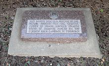
The geographic center of the United States is a point approximately 20 mi (32 km) north of Belle Fourche, South Dakota at 44°58′2.07622″N103°46′17.60283″W. It has been regarded as such by the United States Coast and Geodetic Survey and the U.S. National Geodetic Survey (NGS) since the additions of Alaska and Hawaii to the United States in 1959.

The NTv2 is a standard binary grid shift (.GSB) file format. It can transform coordinates between the NAD27 and NAD83 geodetic reference systems for example. The transformation is bidimensional (2D), or horizontal, and does not require heights.

<span class="mw-page-title-main">Transcontinental Traverse</span>

The Transcontinental Traverse (TCT) was a geodetic survey traverse conducted in the Continental United States by the United States Coast and Geodetic Survey between 1961 and 1970 and the U.S. National Geodetic Survey between 1970 and 1976. It was the most accurate large-area survey ever done prior to Global Positioning System surveys. TCT included over 2,700 survey stations, covered over 13,600 miles (21,900 km), and passed through 44 U.S. states.

References

  1. "National Register Information System". National Register of Historic Places . National Park Service. July 9, 2010.
  2. 1 2 3 4 Pankratz, Richard (1973). "National Register of Historic Places Inventory — Nomination Form: Geodetic Center of the U. S." (PDF). National Park Service . Retrieved 2015-05-12. Two photos circa 1950
  3. Clynch, James R. "Introduction to Datums". [ permanent dead link ] University of New South Wales, Satellite Navigation and Positioning Lab. Archived 2015-01-25 at the Wayback Machine Retrieved 2015-05-11.
  4. 1 2 "Chapter IV: Geodetic Systems" in Geodesy for the Layman, 1959. Retrieved 2015-05-11.
  5. 1 2 3 Dracup, Joseph F. "Geodetic Surveys in the United States: The Beginning and the Next One Hundred Years". NOAA. Retrieved 2015-05-11.
  6. 1 2 3 Jiwani, Z. A., and K. M. Kelly. "History of NAD27 and Subsequent Readjustments In Ontario". Archived 2015-05-18 at the Wayback Machine Ontario Land Surveyor, Fall 1983, pp. 10–15. Retrieved 2015-05-11.
  7. 1 2 3 United States Coast and Geodetic Survey, "Triangulation in Kansas", Special Publication No. 70 (1921). Retrieved 2015-05-10.
  8. Schoewe, Walter H.. "Kansas and the geodetic datum of North America". Transactions of the Kansas Academy of Science 51 (1948) 117–124, www.jstor.org
  9. Hamilton, John. "Azimuths in Control Surveys". Retrieved 2015-05-11.
  10. 1 2 Penry, Jerry. "Meades Ranch". Archived 2015-05-11 at the Wayback Machine Nebraska Surveying. Retrieved 2015-05-11. Archived 2015-05-11 at Wayback Machine.
  11. "National and State Registers of Historic Places: Osborne County". Kansas Historical Society. Retrieved 2015-05-11.
  12. Schwarz, Charles R. "The Need for a New Adjustment" in North American Datum of 1983, NOAA Professional Paper NOS2, pp. 9–10. Retrieved 2015-05-11.
  13. "Impact of NAD83 Adoption". Archived 2015-03-26 at the Wayback Machine Alberta Environment and Sustainable Resource Development. Archived 2014-10-18 at the Wayback Machine Retrieved 2015-05-11.
  14. "FAQs". NOAA. Retrieved 2015-05-11.
  15. "Affirmation of Datum for Surveying and Mapping Activities". NOAA. Retrieved 2015-05-11.
  16. 1 2 "The NGS Data Sheet: Meades Ranch Reset". NOAA. Retrieved 2015-05-11.
  17. "Geodetic Center Tour '08 at Meades Ranch". Archived 2008-05-13 at the Wayback Machine Kansas Society of Land Surveyors. Retrieved 2015-05-11. Archived 2008-05-13 at Wayback Machine.
  18. "Kansas Historical Markers". Kansas Historical Society. Retrieved 2015-05-11. Archived 2015-03-19 at Wayback Machine.