Mercer, Missouri

Last updated
Mercer, Missouri
Mercer County Missouri Incorporated and Unincorporated areas Mercer Highlighted.svg
Location of Mercer, Missouri
Coordinates: 40°30′38″N93°31′48″W / 40.51056°N 93.53000°W / 40.51056; -93.53000 Coordinates: 40°30′38″N93°31′48″W / 40.51056°N 93.53000°W / 40.51056; -93.53000
Country United States
State Missouri
County Mercer
Area
[1]
  Total0.37 sq mi (0.95 km2)
  Land0.37 sq mi (0.95 km2)
  Water0.00 sq mi (0.00 km2)
Elevation
[2]
1,083 ft (330 m)
Population
 (2020)
  Total263
  Density714.67/sq mi (276.29/km2)
Time zone UTC-6 (Central (CST))
  Summer (DST) UTC-5 (CDT)
ZIP code
64661
Area code 660
FIPS code 29-47486 [3]
GNIS feature ID2396751 [2]

Mercer is a city in Mercer County, Missouri, United States. The population was 263 at the 2020 census. [4]

Contents

History

Mercer was platted in the 1870s when the railroad was extended to that point. [5] The community has the name of Marion Merwitt, the daughter of a local pharmacist.

Geography

According to the United States Census Bureau, the city has a total area of 0.37 square miles (0.96 km2), all land. [6]

Demographics

Historical population
CensusPop.Note
1900 340
1910 53356.8%
1920 442−17.1%
1930 364−17.6%
1940 43018.1%
1950 377−12.3%
1960 368−2.4%
1970 364−1.1%
1980 44221.4%
1990 297−32.8%
2000 34215.2%
2010 318−7.0%
2020 263−17.3%
U.S. Decennial Census [7]

2010 census

As of the census [8] of 2010, there were 318 people, 149 households, and 91 families residing in the city. The population density was 859.5 inhabitants per square mile (331.9/km2). There were 183 housing units at an average density of 494.6 per square mile (191.0/km2). The racial makeup of the city was 98.7% White, 0.3% Native American, and 0.9% from two or more races. Hispanic or Latino of any race were 0.6% of the population.

There were 149 households, of which 25.5% had children under the age of 18 living with them, 47.7% were married couples living together, 8.1% had a female householder with no husband present, 5.4% had a male householder with no wife present, and 38.9% were non-families. 38.3% of all households were made up of individuals, and 25.5% had someone living alone who was 65 years of age or older. The average household size was 2.13 and the average family size was 2.81.

The median age in the city was 46.4 years. 23.3% of residents were under the age of 18; 5.3% were between the ages of 18 and 24; 19.6% were from 25 to 44; 29.2% were from 45 to 64; and 22.6% were 65 years of age or older. The gender makeup of the city was 45.9% male and 54.1% female.

2000 census

As of the census [3] of 2000, there were 342 people, 165 households, and 97 families residing in the town. The population density was 966.3 inhabitants per square mile (373.1/km2). There were 193 housing units at an average density of 545.3 per square mile (210.5/km2). The racial makeup of the town was 99.42% White, 0.29% Native American, and 0.29% from two or more races. Hispanic or Latino of any race were 0.29% of the population.

There were 165 households, out of which 24.2% had children under the age of 18 living with them, 46.7% were married couples living together, 9.1% had a female householder with no husband present, and 41.2% were non-families. 38.2% of all households were made up of individuals, and 24.2% had someone living alone who was 65 years of age or older. The average household size was 2.07 and the average family size was 2.75.

In the town the population was spread out, with 21.6% under the age of 18, 6.7% from 18 to 24, 23.7% from 25 to 44, 20.8% from 45 to 64, and 27.2% who were 65 years of age or older. The median age was 44 years. For every 100 females there were 81.0 males. For every 100 females age 18 and over, there were 77.5 males.

The median income for a household in the town was $23,906, and the median income for a family was $27,750. Males had a median income of $24,583 versus $16,406 for females. The per capita income for the town was $13,493. About 18.1% of families and 26.3% of the population were below the poverty line, including 38.2% of those under age 18 and 27.1% of those age 65 or over.

Notable events

Related Research Articles

<span class="mw-page-title-main">Pleasanton, Iowa</span> City in Iowa, United States

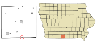
Pleasanton is a city in Decatur County, Iowa, United States. The population was 32 at the time of the 2020 census.

<span class="mw-page-title-main">Mercer, Maine</span> Town in the state of Maine, United States

Mercer is a town in Somerset County, Maine, United States. The town was named after Revolutionary War hero Brigadier General Hugh Mercer. The population was 709 at the 2020 census.

<span class="mw-page-title-main">Watson, Missouri</span> Village in Missouri

Watson is a village in Nishnabotna Township, Atchison County, Missouri, United States. The population was 61 at the 2020 census. It is the westernmost settlement in the state of Missouri, about 120 miles northwest of Kansas City.

<span class="mw-page-title-main">Spickard, Missouri</span> City in Grundy County, Missouri, US

Spickard is a city in Grundy County, Missouri, United States. The population was 222 at the 2020 census.

<span class="mw-page-title-main">Cainsville, Missouri</span> City in Missouri, United States

Cainsville is a city in eastern Harrison County, Missouri, United States. The population was 283 at the 2020 census.

<span class="mw-page-title-main">Big Lake, Missouri</span> Village in Missouri, United States

Big Lake is a village in Holt County, Missouri, United States. The population was 65 at the 2020 census.

<span class="mw-page-title-main">Linneus, Missouri</span> City in Missouri, United States

Linneus is a small city in Linn County, Missouri, United States. The population was 281 at the 2020 census. It is the county seat of Linn County.

<span class="mw-page-title-main">Princeton, Missouri</span> City in Missouri, United States

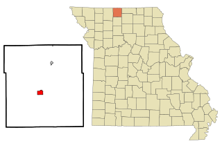
Princeton is the county seat and largest city of Mercer County, Missouri, United States. The population was 1,007 at the 2020 census, down from the 2010 census, which counted 1,166 people. Princeton, Missouri was also the birthplace of the famous frontierswoman Calamity Jane.

<span class="mw-page-title-main">South Lineville, Missouri</span> Village in Missouri, United States

South Lineville is a village in Mercer County, Missouri, United States. The population was 13 at the 2020 census, a decline of fifteen people from the 2010 census.

<span class="mw-page-title-main">Pickering, Missouri</span> Village in Missouri, United States

Pickering is a city in Nodaway County, Missouri, United States. The population was 160 at the 2010 census.

<span class="mw-page-title-main">Bakersfield, Missouri</span> Village in Missouri, United States

Bakersfield is a village in southeastern Ozark County in the Ozarks of southern Missouri, United States. The population was 186 at the 2020 census.

<span class="mw-page-title-main">Pascola, Missouri</span> Village in Missouri, United States

Pascola is a village in Pemiscot County, Missouri, United States. The population was 108 at the 2010 census.

<span class="mw-page-title-main">Moundville, Missouri</span> Village in Missouri, United States

Moundville is a village in southwest Vernon County, Missouri, United States. The population was 124 at the 2010 census.

<span class="mw-page-title-main">Brownville, Nebraska</span> Village in Nebraska, United States

Brownville is a village in Nemaha County, Nebraska, United States. The population was 142 at the 2020 census.

<span class="mw-page-title-main">Mount Moriah, Missouri</span> Village in Missouri, United States

Mount Moriah is a village in eastern Harrison County, Missouri, United States. The population at the 2020 census was 75.

<span class="mw-page-title-main">Mercer, North Dakota</span> City in North Dakota, United States

Mercer is a city in McLean County, North Dakota, United States. The population was 88 at the 2020 census.

<span class="mw-page-title-main">Montezuma, Ohio</span> Village in Ohio, United States

Montezuma is a village in Mercer County, Ohio, United States. The population was 165 at the 2010 census.

<span class="mw-page-title-main">Ionia, Missouri</span> Village in Missouri, United States

Ionia is a village in northern Benton and southern Pettis counties in the U.S. state of Missouri. The population was 88 at the 2010 census.

<span class="mw-page-title-main">Blackburn, Missouri</span> City in Missouri, United States

Blackburn is a city in Lafayette and Saline counties in the U.S. state of Missouri and is part of the Kansas City metropolitan area. The population was 249 at the 2010 census.

<span class="mw-page-title-main">Argyle, Missouri</span> Town in Missouri, United States

Argyle is a town in Maries and Osage counties in the U.S. state of Missouri. The population was 144 at the 2020 census.

References

  1. "ArcGIS REST Services Directory". United States Census Bureau. Retrieved August 28, 2022.
  2. 1 2 U.S. Geological Survey Geographic Names Information System: Mercer, Missouri
  3. 1 2 "U.S. Census website". United States Census Bureau . Retrieved 2008-01-31.
  4. "Explore Census Data". data.census.gov. Retrieved 2021-12-16.
  5. "Mercer County Place Names, 1928–1945". The State Historical Society of Missouri. Archived from the original on June 24, 2016. Retrieved November 5, 2016.
  6. "US Gazetteer files 2010". United States Census Bureau. Archived from the original on 2012-01-25. Retrieved 2012-07-08.
  7. "Census of Population and Housing". Census.gov. Retrieved June 4, 2015.
  8. "U.S. Census website". United States Census Bureau . Retrieved 2012-07-08.
  9. "Class 1 State Tournament Bracket". Missouri State High School Activities Association website. 2013-03-17. Retrieved 2013-04-25.
  10. "Class 1 State Tournament Bracket". Missouri State High School Activities Association website. 2017-03-11. Retrieved 2017-03-16.