South Lineville, Missouri

Last updated
South Lineville, Missouri
Mercer County Missouri Incorporated and Unincorporated areas South Lineville Highlighted.svg
Location of South Lineville, Missouri
Coordinates: 40°34′43″N93°31′27″W / 40.57861°N 93.52417°W / 40.57861; -93.52417 Coordinates: 40°34′43″N93°31′27″W / 40.57861°N 93.52417°W / 40.57861; -93.52417
Country United States
State Missouri
County Mercer
Area
[1]
  Total0.05 sq mi (0.14 km2)
  Land0.05 sq mi (0.14 km2)
  Water0.00 sq mi (0.00 km2)
Elevation
[2]
1,093 ft (333 m)
Population
 (2020)
  Total13
  Density240.74/sq mi (92.37/km2)
Time zone UTC-6 (Central (CST))
  Summer (DST) UTC-5 (CDT)
FIPS code 29-68942 [3]
GNIS feature ID2397667 [2]

South Lineville is a village in Mercer County, Missouri, United States. The population was 13 at the 2020 census, [4] a decline of fifteen people from the 2010 census.

Contents

The name Lineville refers to the fact the town site lies near the Missouri—Iowa state line. [5] The village is located directly south of its twin city of Lineville, Iowa.

Geography

South Lineville is located at 40°34′43″N93°31′29″W / 40.57861°N 93.52472°W / 40.57861; -93.52472 (40.578582, -93.524694). [6]

According to the United States Census Bureau, the village has a total area of 0.06 square miles (0.16 km2), all land. [7]

Demographics

Historical population
CensusPop.Note
1910 77
1920 10637.7%
1930 79−25.5%
1940 823.8%
1950 9212.2%
1960 76−17.4%
1970 52−31.6%
1980 555.8%
1990 40−27.3%
2000 37−7.5%
2010 28−24.3%
2020 13−53.6%
U.S. Decennial Census [8]

2010 census

As of the census [9] of 2010, there were 28 people, 13 households, and 6 families residing in the village. The population density was 466.7 inhabitants per square mile (180.2/km2). There were 16 housing units at an average density of 266.7 per square mile (103.0/km2). The racial makeup of the village was 100.0% White.

There were 13 households, of which 15.4% had children under the age of 18 living with them, 46.2% were married couples living together, and 53.8% were non-families. 38.5% of all households were made up of individuals, and 15.4% had someone living alone who was 65 years of age or older. The average household size was 2.15 and the average family size was 3.17.

The median age in the village was 48.5 years. 17.9% of residents were under the age of 18; 3.5% were between the ages of 18 and 24; 21.4% were from 25 to 44; 32.2% were from 45 to 64; and 25% were 65 years of age or older. The gender makeup of the village was 60.7% male and 39.3% female.

2000 census

As of the census [3] of 2000, there were 37 people, 15 households, and 10 families residing in the town. The population density was 636.8 inhabitants per square mile (245.9/km2). There were 17 housing units at an average density of 292.6 per square mile (113.0/km2). The racial makeup of the town was 100.00% White.

There were 15 households, out of which 26.7% had children under the age of 18 living with them, 66.7% were married couples living together, 6.7% had a female householder with no husband present, and 26.7% were non-families. 26.7% of all households were made up of individuals, and 13.3% had someone living alone who was 65 years of age or older. The average household size was 2.47 and the average family size was 2.91.

In the town the population was spread out, with 27.0% under the age of 18, 10.8% from 18 to 24, 24.3% from 25 to 44, 21.6% from 45 to 64, and 16.2% who were 65 years of age or older. The median age was 36 years. For every 100 females, there were 105.6 males. For every 100 females age 18 and over, there were 125.0 males.

The median income for a household in the town was $26,875, and the median income for a family was $26,250. Males had a median income of $27,500 versus $11,250 for females. The per capita income for the town was $9,153. There were 20.0% of families and 15.8% of the population living below the poverty line, including no under eighteens and 28.6% of those over 64.

Related Research Articles

<span class="mw-page-title-main">Clio, Iowa</span> City in Iowa, United States

Clio is a city in Wayne County, Iowa, United States. The population was 67 at the 2020 census.

<span class="mw-page-title-main">Lineville, Iowa</span> City in Iowa, United States

Lineville is a city in Wayne County, Iowa, United States. The population was 195 at the time of the 2020 census.

<span class="mw-page-title-main">West Kennebunk, Maine</span> Census-designated place in Maine, United States

West Kennebunk is a census-designated place (CDP) in the town of Kennebunk in York County, Maine, United States. The population was 1,176 at the 2010 census. It is part of the Portland–South Portland–Biddeford, Maine Metropolitan Statistical Area.

<span class="mw-page-title-main">Stanwood, Michigan</span> Village in Michigan, United States

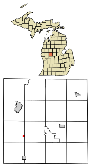
Stanwood is a village in Mecosta County of the U.S. state of Michigan. The population was 211 at the 2010 census. The village is within Mecosta Township.

<span class="mw-page-title-main">Passaic, Missouri</span> Town in Missouri, United States

Passaic is a town in Bates County, Missouri, and is part of the Kansas City metropolitan area within the United States.

<span class="mw-page-title-main">Hartsburg, Missouri</span> Village in Missouri, United States

Hartsburg is a village in southern Boone County, Missouri, United States. It is part of the Columbia, Missouri Metropolitan Statistical Area. The population was 133 per the 2020 census.

<span class="mw-page-title-main">Gunn City, Missouri</span> Village in Missouri, United States

Gunn City is a village in Cass County, Missouri, United States. The population was 118 at the 2010 census. It is part of the Kansas City metropolitan area.

<span class="mw-page-title-main">Jerico Springs, Missouri</span> Village in Missouri, United States

Jerico Springs is a village in Cedar County, Missouri, United States. The population was 160 at the 2020 census.

<span class="mw-page-title-main">Cave, Missouri</span> Populated Place in Missouri, United States

Cave is a populated place in Lincoln County, Missouri, United States. The population was 5 at the 2010 census. With a 2020 population of 5, it is the 939th largest city in Missouri and the 19481st largest city in the United States. Cave is currently declining at a rate of 0.00% annually and its population has decreased by 0.00% since the most recent census, which recorded a population of 5 in 2010.

<span class="mw-page-title-main">Grand Falls Plaza, Missouri</span> Village in Missouri, United States

Grand Falls Plaza is a village in Newton County, Missouri, United States. The population was 114 at the 2010 census, at which time it was a town. It is part of the Joplin, Missouri Metropolitan Statistical Area.

<span class="mw-page-title-main">Grantwood Village, Missouri</span> Town in Missouri, United States

Grantwood Village is a town in St. Louis County, Missouri, United States. The population was 863 at the 2010 census.

<span class="mw-page-title-main">Norwood Court, Missouri</span> Village in Missouri, United States

Norwood Court is a village in St. Louis County, Missouri, United States. The population was 959 at the 2010 census.

<span class="mw-page-title-main">Deerfield, Missouri</span> Village in Missouri, United States

Deerfield is a village in Vernon County, Missouri, United States. The population was 40 at the 2020 census.

<span class="mw-page-title-main">Moundville, Missouri</span> Village in Missouri, United States

Moundville is a village in southwest Vernon County, Missouri, United States. The population was 124 at the 2010 census.

<span class="mw-page-title-main">Richards, Missouri</span> Village in Missouri, United States

Richards is a village in northwest Vernon County, Missouri, United States. The population was 96 at the 2010 census.

<span class="mw-page-title-main">Spring Hill, Minnesota</span> City in Minnesota, United States

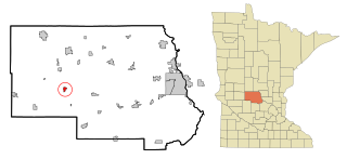
Spring Hill is a city in Stearns County, Minnesota, United States. The population was 85 at the 2010 census. It is part of the St. Cloud Metropolitan Statistical Area.

<span class="mw-page-title-main">Northville, South Dakota</span> Town in South Dakota, United States

Northville is a town in Spink County, South Dakota, United States. The population was 139 at the 2020 census.

<span class="mw-page-title-main">Ionia, Missouri</span> Village in Missouri, United States

Ionia is a village in northern Benton and southern Pettis counties in the U.S. state of Missouri. The population was 88 at the 2010 census.

<span class="mw-page-title-main">Argyle, Missouri</span> Town in Missouri, United States

Argyle is a town in Maries and Osage counties in the U.S. state of Missouri. The population was 144 at the 2020 census.

Afton is a village in Chenango County, New York, United States. The population was 822 at the 2010 census. The village is named after the poem "Sweet Afton" by Scottish poet Robert Burns, referring to the River Afton in Ayrshire, Scotland.

References

  1. "ArcGIS REST Services Directory". United States Census Bureau. Retrieved August 28, 2022.
  2. 1 2 U.S. Geological Survey Geographic Names Information System: South Lineville, Missouri
  3. 1 2 "U.S. Census website". United States Census Bureau . Retrieved 2008-01-31.
  4. "Explore Census Data". data.census.gov. Retrieved 2021-12-16.
  5. "Mercer County Place Names, 1928–1945". The State Historical Society of Missouri. Archived from the original on June 24, 2016. Retrieved November 5, 2016.
  6. "US Gazetteer files: 2010, 2000, and 1990". United States Census Bureau. 2011-02-12. Retrieved 2011-04-23.
  7. "US Gazetteer files 2010". United States Census Bureau. Archived from the original on 2012-01-25. Retrieved 2012-07-08.
  8. "Census of Population and Housing". Census.gov. Retrieved June 4, 2015.
  9. "U.S. Census website". United States Census Bureau . Retrieved 2012-07-08.