Related Research Articles

Stilesville is a town in Franklin Township, Hendricks County, Indiana, United States. The population was 316 at the 2010 Census.

Oliver is a census-designated place (CDP) in Fayette County, Pennsylvania, United States. The population was 2,535 at the 2010 census, down from 2,925 at the 2000 census. Oliver is located in North Union Township.

Lubeck is a census-designated place (CDP) in Wood County, West Virginia, United States. It is part of the Parkersburg-Marietta-Vienna, WV-OH Metropolitan Statistical Area. The population was 1,311 at the 2010 census. Though first named Watertown, postmaster Theodore Frederick Henry Slevogt in 1856 changed the name to Lubeck after his hometown in Germany.
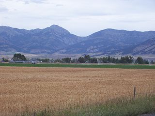
The Bridger Range, also known as the Bridger Mountains, is a subrange of the Rocky Mountains in southwestern Montana in the United States. The range runs mostly in a north–south direction between Bozeman and Maudlow. It is separated from the Gallatin Range to the south by Bozeman Pass; from the Horseshoe Hills to the west by Dry Creek; from the Crazy Mountains to the east by the Shields River valley; and from the Big Belt Mountains to the north by Sixteen Mile Creek. The highest point in the Bridger Range is Sacagawea Peak, which is visible to the northeast from Bozeman.

Bucksnort is a spring in Hickman County, Tennessee, United States, located on Sugar Creek, 0.2 miles (0.32 km) downstream of the confluence of the South Fork of Sugar Creek, 0.2 miles (0.32 km) to the south-east of Exit 152 on Interstate 40, and 2.7 miles (4.3 km) west of Spot. There are no U.S. Census statistics for the location and there is no post office. A trout farm business operated just upstream and adjacent to the I-40 in 1967, operated by Mr. and Mrs. Joda Austin.

Izalzu – Itzaltzu is a town and municipality located in the province and autonomous community of Navarre, northern Spain.

Prophetstown Township is located in Whiteside County, Illinois, United States. As of the 2010 census, its population was 2,615 and it contained 1,162 housing units.

Whitewater is a census-designated place in Riverside County, California. It is directly off Interstate 10 halfway between North Palm Springs and Cabazon on the way from Palm Springs to Los Angeles. It is known as the site of the San Gorgonio Pass Wind Farm. The ZIP Code is 92282, and the community is inside area code 760. The population was 859 at the 2010 census. The elevation is 1,575 feet (480 m).

Merrimon is an unincorporated community in Carteret County, North Carolina, United States, approximately 20 miles (32 km) away from Beaufort. It is home to the Jonaquins Landing and Sand Hills housing developments. The only access to the Merrimon area is via Merrimon Road.

Walesboro is an unincorporated community in Wayne Township, Bartholomew County, in the U.S. state of Indiana.
McCoysburg is an unincorporated community in Hanging Grove Township, Jasper County, Indiana.
Avondale-Melbourne Heights is a neighborhood in Louisville, Kentucky, United States. Its boundaries are Breckenridge Lane on the east, Hikes Lane to the south, Furman Boulevard to the west, and the Watterson Expressway on the north. The sixth-class city of Meadowview Estates is excluded.

Brunswick Air Force Station is a closed United States Air Force General Surveillance Radar station. It is located 2.5 miles (4.0 km) east-southeast of Brunswick, Maine. It was closed in 1965.

KLBT is a radio station airing a Contemporary Christian Music format, licensed to Beaumont, Texas, broadcasting on 88.1 MHz FM. The station serves the Beaumont – Port Arthur metropolitan area, and is owned by The King's Musician Educational Foundation, Inc.
Mechanicsburg is an unincorporated community in Auburn Township, Crawford County, Ohio, United States.
Beech Grove is an unincorporated community in Knox County, Tennessee, in the United States.
Edgewood Lake is an unincorporated community in Greencastle Township, Putnam County, in the U.S. state of Indiana.
London Heights is an unincorporated community in Moral Township, Shelby County, in the U.S. state of Indiana.
Craddock is an unincorporated community in southern Phelps County, in the U.S. state of Missouri. The community is one mile east of U.S. Route 63. Licking is approximately nine miles to the south in Texas County and Edgar Springs is about nine miles to the north.
References
- ↑ "Messongo". Geographic Names Information System . United States Geological Survey, United States Department of the Interior . Retrieved February 9, 2014.

Coordinates: 37°54′52″N75°38′22″W / 37.91444°N 75.63944°W
| | This Accomack County, Virginia state location article is a stub. You can help Wikipedia by expanding it. |