Metaline, Washington

Last updated

Metaline, Washington
Metaline District geologic map.jpg
Geologic map of the Metaline area, and Metaline Mine location
Pend Oreille County Washington Incorporated and Unincorporated areas Metaline Highlighted.svg
Location of Metaline, Washington
Coordinates: 48°51′7″N117°23′21″W / 48.85194°N 117.38917°W / 48.85194; -117.38917 [1]
CountryUnited States
State Washington
County Pend Oreille
Area
[2]
  Total0.39 sq mi (1.01 km2)
  Land0.31 sq mi (0.79 km2)
  Water0.09 sq mi (0.22 km2)
Elevation
2,021 ft (616 m)
Population
 (2020)
  Total162
  Density420/sq mi (160/km2)
Time zone UTC-8 (Pacific (PST))
  Summer (DST) UTC-7 (PDT)
ZIP code
99152
Area code 509
FIPS code 53-45285
GNIS feature ID1523022 [3]

Metaline is a town in Pend Oreille County, Washington, United States. The population was 162 at the 2020 census.

Contents

History

The Pend Oreille River was deepened at Box Canyon in 1906, allowing navigation to Metaline. The Metaline Mine then started producing lead from the Metaline Formation, a Middle Cambrian age limestone. By 1951, the mine had produced over 10,000 pounds of lead, and almost 37,000 pounds of zinc. In 1955, Metaline had a population of 400. [4] [5]

Metaline was officially incorporated on October 6, 1948.

Geography

According to the United States Census Bureau, Metaline has a total area of 0.31 square miles (0.80 km2), all of it land. [6]

Climate

This climatic region is typified by large seasonal temperature differences, with warm to hot (and often humid) summers and cold (sometimes severely cold) winters. According to the Köppen Climate Classification system, Metaline has a humid continental climate, abbreviated "Dfb" on climate maps. [7]

Demographics

Historical population
CensusPop.Note
1950 563
1960 299−46.9%
1970 197−34.1%
1980 190−3.6%
1990 1984.2%
2000 162−18.2%
2010 1736.8%
2020 162−6.4%
U.S. Decennial Census [8]
2020 Census [9]

2010 census

As of the 2010 census, [10] there were 173 people, 86 households, and 44 families residing in the town. The population density was 558.1 inhabitants per square mile (215.5/km2). There were 103 housing units at an average density of 332.3 per square mile (128.3/km2). The racial makeup of the town was 96.0% White, 2.3% Native American, and 1.7% from two or more races. Hispanic or Latino of any race were 2.3% of the population.

There were 86 households, of which 23.3% had children under the age of 18 living with them, 40.7% were married couples living together, 2.3% had a female householder with no husband present, 8.1% had a male householder with no wife present, and 48.8% were non-families. 44.2% of all households were made up of individuals, and 15.1% had someone living alone who was 65 years of age or older. The average household size was 2.01 and the average family size was 2.84.

The median age in the town was 50.2 years. 20.8% of residents were under the age of 18; 4.1% were between the ages of 18 and 24; 18.5% were from 25 to 44; 39.3% were from 45 to 64; and 17.3% were 65 years of age or older. The gender makeup of the town was 53.2% male and 46.8% female.

2000 census

As of the 2000 census, there were 162 people, 73 households, and 44 families residing in the town. The population density was 533.5 people per square mile (208.5/km2). There were 91 housing units at an average density of 299.7 per square mile (117.1/km2). The racial makeup of the town was 91.98% White, 1.23% Native American, 0.62% Pacific Islander, and 6.17% from two or more races. Hispanic or Latino of any race were 1.23% of the population.

There were 73 households, out of which 26.0% had children under the age of 18 living with them, 45.2% were married couples living together, 11.0% had a female householder with no husband present, and 38.4% were non-families. 35.6% of all households were made up of individuals, and 16.4% had someone living alone who was 65 years of age or older. The average household size was 2.22 and the average family size was 2.82.

In the town, the population was spread out, with 25.9% under the age of 18, 4.3% from 18 to 24, 24.7% from 25 to 44, 30.2% from 45 to 64, and 14.8% who were 65 years of age or older. The median age was 42 years. For every 100 females, there were 110.4 males. For every 100 females age 18 and over, there were 118.2 males.

The median income for a household in the town was $22,981, and the median income for a family was $23,750. Males had a median income of $35,000 versus $11,563 for females. The per capita income for the town was $11,262. About 25.0% of families and 32.6% of the population were below the poverty line, including 48.1% of those under the age of eighteen and none of those 65 or over.

Related Research Articles

<span class="mw-page-title-main">Stevens County, Washington</span> County in Washington, United States

Stevens County is a county located in the U.S. state of Washington along the Canada–US border. At the 2020 census, its population was 46,445. As of July 2021, the population was estimated to be 47,426. The county seat and largest city is Colville. The county was created in 1863 and named after Isaac Stevens, the first governor of Washington Territory.

<span class="mw-page-title-main">Pend Oreille County, Washington</span> County in Washington, United States

Pend Oreille County is a county located in the northeast corner of the U.S. state of Washington, along the Canada–US border. As of the 2020 census, the population was 13,401. The county seat and largest city is Newport.

<span class="mw-page-title-main">Bonner County, Idaho</span> County in Idaho, United States

Bonner County is a county in the northern part of the U.S. state of Idaho. As of the 2020 census, the population was 47,110. The county seat and largest city is Sandpoint. Partitioned from Kootenai County and established in 1907, it was named for Edwin L. Bonner, a ferry operator.

<span class="mw-page-title-main">Clark Fork, Idaho</span> City in Idaho, United States

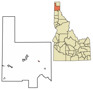
Clark Fork is a small town in Bonner County, Idaho. The population was 536 at the time of the 2010 census.

<span class="mw-page-title-main">Hope, Idaho</span> City in Idaho, United States

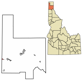
Hope is a city in Bonner County, Idaho, United States. The population was 86 at the 2010 census.

<span class="mw-page-title-main">Oldtown, Idaho</span> City in Idaho, United States

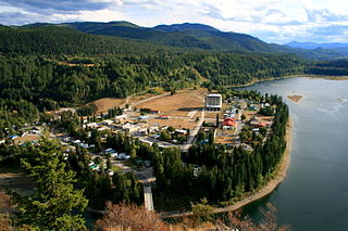
Oldtown is a city in Bonner County, Idaho and suburb of Newport, Washington, with a population of 184 at the 2010 census. It is located on the Pend Oreille River, just east of Newport. There are no natural or physical barriers, and it is strictly a political division, separated by the straight-line state boundary. Oldtown is squeezed between this boundary to the west and the river to the east, leaving the main business district on U.S. Route 2 with only 700 feet of space in which to operate on the Idaho side. Many homes are located in the south end on the other side of the railroad, as the Pend Oreille is somewhat further away here.

<span class="mw-page-title-main">Ponderay, Idaho</span> City in Idaho, United States

Ponderay is a city in Bonner County, Idaho. The population was 1,137 at the 2010 census, up from 638 in 2000. Ponderay's city motto is "Little City with the Big Future". Its name is an English phonetic spelling of the French words “Pend Oreille”, the name of the lake the city sits upon.

<span class="mw-page-title-main">Priest River, Idaho</span> City in Idaho, United States

Priest River is a city in Bonner County, Idaho. The population was 1,751 at the 2010 census. Located in the Idaho Panhandle region of the state, the city is at the mouth of the Priest River on the Pend Oreille River.

<span class="mw-page-title-main">Oakfield, Maine</span> Town in the state of Maine, United States

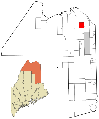
Oakfield is a town in Aroostook County, Maine, United States. The population was 661 at the 2020 census. The village of Oakfield, listed as a census-designated place, is in the northwestern corner of the town.

<span class="mw-page-title-main">Stockholm, Maine</span> Town in the state of Maine, United States

Stockholm is a town in Aroostook County, Maine, United States. The population was 250 at the 2020 census.

Northfield is a town in Washington County, Maine, United States. The population was 178 at the 2020 census.

<span class="mw-page-title-main">Superior, Montana</span> Town in Montana, United States

Superior is a town in, and the county seat of, Mineral County, Montana, United States. The population was 830 at the 2020 census.

<span class="mw-page-title-main">Cusick, Washington</span> Town in Pend Oreille County, Washington, United States

Cusick is a town in Pend Oreille County, Washington, United States. The population was 153 at the 2020 census. Cusick is the headquarters of the federally recognized Kalispel Indian Community of the Kalispel Reservation.

<span class="mw-page-title-main">Ione, Washington</span> Town in Pend Oreille County, Washington, United States

Ione is a town in Pend Oreille County, Washington, United States. The population was 428 at the 2020 census.

<span class="mw-page-title-main">Metaline Falls, Washington</span> Town in Pend Oreille County, Washington, United States

Metaline Falls is a town in Pend Oreille County, Washington, United States. The population was 272 at the 2020 census.

<span class="mw-page-title-main">Newport, Washington</span> City in Washington, United States

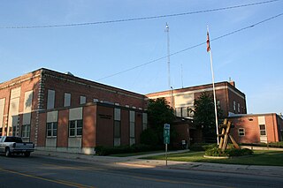
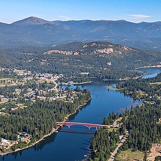
Newport is a city in and the county seat of Pend Oreille County, Washington, United States. The population was 2,114 at the 2020 census.

<span class="mw-page-title-main">Anawalt, West Virginia</span> Town in West Virginia, United States

Anawalt is a town in McDowell County, West Virginia, United States. At one time it was known as Jeanette. It is named in honor of James White Anawalt, who was then manager of Union Supply Company, a subsidiary of the United States Steel Company. The population was 186 at the 2020 census. Coal mining was the town's chief industry.

<span class="mw-page-title-main">Iaeger, West Virginia</span> Town in West Virginia, United States

Iaeger is a town in McDowell County, West Virginia, United States. The population was 257 at the 2020 census.

<span class="mw-page-title-main">Bancroft, West Virginia</span> Town in West Virginia, United States

Bancroft is a town in Putnam County, West Virginia, United States, along the Kanawha River. The population was 389 at the 2020 census. It is part of the Huntington–Ashland metropolitan area.

<span class="mw-page-title-main">Couderay, Wisconsin</span> Village in Wisconsin, United States

Couderay is a village in Sawyer County, Wisconsin, United States, along the Couderay River. The population was 88 at the 2010 census. The village is located within the Town of Couderay.

References

  1. "US Gazetteer files: 2010, 2000, and 1990". United States Census Bureau. February 12, 2011. Retrieved April 23, 2011.
  2. "2019 U.S. Gazetteer Files". United States Census Bureau. Retrieved August 7, 2020.
  3. "US Board on Geographic Names". United States Geological Survey. October 25, 2007. Retrieved January 31, 2008.
  4. Dings, McClelland; Whitebread, Donald. "Geology and Ore Deposits of the Metaline Zinc-Lead District Pend Oreille County Washington, USGS Professional Paper 489" (PDF). USGS. pp. 2, 56–58. Retrieved July 2, 2020.
  5. McConnel, Roger; Anderson, Roy (1968). Ridge, John (ed.). The Metaline District, Washington, in Ore deposits of the United States, 1933-1967. New York: The American Institute of Mining, Metallurgical, and Petroleum engineers, Inc. pp. 1460–1480.
  6. "US Gazetteer files 2010". United States Census Bureau. Archived from the original on January 25, 2012. Retrieved December 19, 2012.
  7. Climate Summary for Metaline, Washington
  8. United States Census Bureau. "Census of Population and Housing" . Retrieved October 4, 2013.
  9. "Census Bureau profile: Metaline, Washington". United States Census Bureau. May 2023. Retrieved May 14, 2024.
  10. "U.S. Census website". United States Census Bureau . Retrieved December 19, 2012.