Metaline Falls, Washington

Last updated

Metaline Falls, Washington
Metaline falls.jpg
Metaline Falls
Pend Oreille County Washington Incorporated and Unincorporated areas Metaline Falls Highlighted.svg
Location of Metaline Falls, Washington
Coordinates: 48°51′41″N117°22′15″W / 48.86139°N 117.37083°W / 48.86139; -117.37083
Country United States
State Washington
County Pend Oreille
Area
[1]
  Total0.26 sq mi (0.68 km2)
  Land0.20 sq mi (0.52 km2)
  Water0.06 sq mi (0.17 km2)
Elevation
2,090 ft (637 m)
Population
 (2020) [2]
  Total272
  Density1,046.15/sq mi (400.00/km2)
Time zone UTC-8 (Pacific (PST))
  Summer (DST) UTC-7 (PDT)
ZIP code
99153
Area code 509
FIPS code 53-45320
GNIS feature ID1523023 [3]

Metaline Falls is a town in Pend Oreille County, Washington, United States. The population was 272 at the 2020 census. [2]

Contents

History

By 1810, European fur traders were crossing the area. The settlement of Metaline Falls was founded in 1900, with most of its residents then employed by the Mammoth and Morning lead-zinc mines. [4] Metaline Falls was officially incorporated on May 3, 1911. [5]

The name Metaline comes from the abundance of lead ore, galena, found in the region. Though these lead deposits were known since 1869, mining did not commence until 1886. Then in 1910, Metaline Falls was connected with the Idaho and Washington Northern Railroad. The Lehigh Portland Cement Co. plant was soon built, taking advantage of the region's limestone deposits. The Pend Oreille Mine was developed in 1929 by Lewis P. Larsen, and combined with production from the Grandview Mine and the Metaline Mine, the area became the state's largest producer of lead and zinc. [6] [7] [8] [9]

Metaline Falls circa 1980 Metaline Falls, Washington, circa 1980 (50729904433).jpg
Metaline Falls circa 1980

In 1942, Executive Order 9066 was issued, resulting in the forced internment of 120,000 Japanese-Americans. George Kubota, Sr., the patriarch of a Japanese-American family who ran a hardware store in town, was arrested and imprisoned by the FBI in Spokane. The editors of the Metaline Falls newspaper and the majority of residents in town protested the arrest, vouching for the Kubota family's loyalty. The FBI eventually released Kubota from custody and did not send the family to an internment camp. [10] [11]

Geography

Geologic map of the Metaline Falls area and surrounding mines. Metaline District geologic map.jpg
Geologic map of the Metaline Falls area and surrounding mines.

According to the United States Census Bureau, the town has a total area of 0.21 square miles (0.54 km2), all of it land. [12]

Metaline Falls is located on the east bank of the Pend Oreille River as it flows north towards Canada. The town of [Metaline Falls, Washington] lies directly upstream from Metaline on the opposite bank of the river. The river makes a zig zag at Metaline Falls, turning briefly to the east to get around Washington Rock, which towers over Metaline Falls immediately to the north of the town and the Metaline Falls Bridge. Sullivan Creek, which drains nearby Sullivan Lake, enters the river at Metaline Falls. The river is the site of the lowest lying terrain in the Metaline Falls area, as it cuts its way through the peaks of the Selkirk Mountains which rise over 1,000 feet above the river within just a mile of the town. [13]

The town is surrounded by the Colville National Forest, with the rugged and isolated Salmo-Priest Wilderness coming within just a few miles to the east. [14] The Sullivan Lake Ranger District is headquartered in Metaline Falls. [15]

State Route 31 passes through Metaline Falls, connecting the town to the rest of the state highway system at Tiger in the south and with Canada at Nelway, British Columbia. [13] [16]

National protected areas

Climate

Metaline Falls has a dry-summer Humid continental climate (Dsb) according to the Köppen climate classification system.

Climate data for Metaline Falls
MonthJanFebMarAprMayJunJulAugSepOctNovDecYear
Record high °F (°C)49
(9)
57
(14)
71
(22)
87
(31)
98
(37)
98
(37)
104
(40)
108
(42)
96
(36)
87
(31)
59
(15)
55
(13)
108
(42)
Mean daily maximum °F (°C)29.9
(−1.2)
37.3
(2.9)
46.9
(8.3)
58.9
(14.9)
68.5
(20.3)
74.4
(23.6)
83.9
(28.8)
82.3
(27.9)
72.8
(22.7)
57.2
(14.0)
39.6
(4.2)
32.4
(0.2)
57
(14)
Mean daily minimum °F (°C)16.6
(−8.6)
19.5
(−6.9)
25.2
(−3.8)
31.5
(−0.3)
39
(4)
45
(7)
48.6
(9.2)
46.9
(8.3)
41.3
(5.2)
34.7
(1.5)
26.9
(−2.8)
21.7
(−5.7)
33.1
(0.6)
Record low °F (°C)−29
(−34)
−28
(−33)
−9
(−23)
1
(−17)
22
(−6)
28
(−2)
31
(−1)
33
(1)
20
(−7)
−1
(−18)
−6
(−21)
−24
(−31)
−29
(−34)
Average precipitation inches (cm)3
(7.6)
2.27
(5.8)
2.12
(5.4)
1.8
(4.6)
2.35
(6.0)
2.71
(6.9)
1.25
(3.2)
1.07
(2.7)
1.7
(4.3)
2.65
(6.7)
3.11
(7.9)
3.35
(8.5)
27.38
(69.5)
Average snowfall inches (cm)26.3
(67)
15.7
(40)
8.5
(22)
0.7
(1.8)
0.1
(0.25)
0
(0)
0
(0)
0
(0)
0
(0)
1
(2.5)
9.8
(25)
23.1
(59)
85.2
(216)
Average precipitation days141212101112667111315129
Source: [17]

Demographics

Historical population
CensusPop.Note
1920 153
1930 316106.5%
1940 45343.4%
1950 54720.8%
1960 469−14.3%
1970 307−34.5%
1980 296−3.6%
1990 210−29.1%
2000 2236.2%
2010 2386.7%
2020 27214.3%

2010 census

As of the 2010 census, [18] there were 238 people, 124 households, and 54 families residing in the town. The population density was 1,133.3 inhabitants per square mile (437.6/km2). There were 206 housing units at an average density of 981.0 per square mile (378.8/km2). The racial makeup of the town was 94.5% White, 0.4% African American, 2.1% Native American, 0.8% Asian, and 2.1% from two or more races. Hispanic or Latino of any race were 1.7% of the population.

There were 124 households, of which 24.2% had children under the age of 18 living with them, 36.3% were married couples living together, 4.0% had a female householder with no husband present, 3.2% had a male householder with no wife present, and 56.5% were non-families. 49.2% of all households were made up of individuals, and 18.5% had someone living alone who was 65 years of age or older. The average household size was 1.92 and the average family size was 2.91.

The median age in the town was 48.3 years. 20.6% of residents were under the age of 18; 4.6% were between the ages of 18 and 24; 18.9% were from 25 to 44; 37.8% were from 45 to 64; and 18.1% were 65 years of age or older. The gender makeup of the town was 47.9% male and 52.1% female.

2000 census

As of the 2000 census, there were 223 people, 122 households, and 52 families residing in the town. The population density was 1,076.1 people per square mile (410.0/km2). There were 192 housing units at an average density of 926.5 per square mile (353.0/km2). The racial makeup of the town was 96.86% White, 1.35% Asian, 0.45% from other races, and 1.35% from two or more races. Hispanic or Latino of any race were 0.45% of the population.

There were 122 households, out of which 18.0% had children under the age of 18 living with them, 36.1% were married couples living together, 4.9% had a female householder with no husband present, and 56.6% were non-families. 54.1% of all households were made up of individuals, and 21.3% had someone living alone who was 65 years of age or older. The average household size was 1.83 and the average family size was 2.79.

In the town, the population was spread out, with 19.3% under the age of 18, 3.6% from 18 to 24, 21.1% from 25 to 44, 33.2% from 45 to 64, and 22.9% who were 65 years of age or older. The median age was 49 years. For every 100 females, there were 95.6 males. For every 100 females age 18 and over, there were 85.6 males.

The median income for a household in the town was $17,083, and the median income for a family was $35,250. Males had a median income of $36,250 versus $18,333 for females. The per capita income for the town was $16,390. About 24.4% of families and 33.2% of the population were below the poverty line, including 48.1% of those under the age of eighteen and 16.2% of those 65 or over.

Arts and culture

Historical sites and buildings

Sites listed on National Register of Historic Places
Larson House.jpg
Lewis P. Larson House
Metaline Falls School NRHP 88001518 Pend Oreille County, WA.jpg
Metaline Falls School
Washington Hotel, Metaline Falls, WA.jpg
Washington Hotel
Metaline Falls (3942364911).jpg
Lewis Larson Apartments

Metaline Falls is home to four of Pend Oreille County's six locations on the National Register of Historic Places. The Lewis P. Larson House, built in 1910 and designed by Kirtland Cutter is an English cottage style home. The Pend Oreille Mines and Metals Building, now known as the Lewis Larson Apartments, is the last remaining structure in town that was part of Larson's mining empire. The Washington Hotel, built in 1910 by Larson. The Metaline Falls School, also designed by Cutter, was built in 1912 in the classical revival style. The school was abandoned in 1972 and sat unmaintained until 1990 when local residents came together to take care of the historic building, which is now known as the Cutter Theater and serves as a community center. [19] [20]

Media

The train sequences of the 1993 film Benny & Joon were filmed in the Metaline Falls area; the 1997 film The Postman was filmed in part in the area. The town's geographic location is similar to that of the fictitious town of Twin Peaks from the TV series of the same name ("Five miles south of the Canadian border, twelve miles west of the state line"). [21]

Education

Metaline Falls is located in the Selkirk School District, which serves the residents of northern Pend Oreille County. Metaline Falls is home to the Selkirk Elementary School, while the combined middle and high schools are located on State Route 31 near Ione. The high school's mascot is the Rangers. [22]

Related Research Articles

<span class="mw-page-title-main">Stevens County, Washington</span> County in Washington, United States

Stevens County is a county located in the U.S. state of Washington along the Canada–US border. At the 2020 census, its population was 46,445. As of July 2021, the population was estimated to be 47,426. The county seat and largest city is Colville. The county was created in 1863 and named after Isaac Stevens, the first governor of Washington Territory.

<span class="mw-page-title-main">Pend Oreille County, Washington</span> County in Washington, United States

Pend Oreille County is a county located in the northeast corner of the U.S. state of Washington, along the Canada–US border. As of the 2020 census, the population was 13,401. The county seat and largest city is Newport.

<span class="mw-page-title-main">Bonner County, Idaho</span> County in Idaho, United States

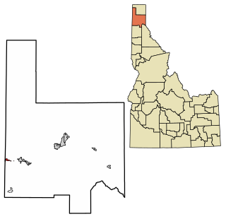
Bonner County is a county in the northern part of the U.S. state of Idaho. As of the 2020 census, the population was 47,110. The county seat and largest city is Sandpoint. Partitioned from Kootenai County and established in 1907, it was named for Edwin L. Bonner, a ferry operator.

<span class="mw-page-title-main">Clark Fork, Idaho</span> City in Idaho, United States

Clark Fork is a small town in Bonner County, Idaho. The population was 536 at the time of the 2010 census.

<span class="mw-page-title-main">Oldtown, Idaho</span> City in Idaho, United States

Oldtown is a city in Bonner County, Idaho and suburb of Newport, Washington, with a population of 184 at the 2010 census. It is located on the Pend Oreille River, just east of Newport. There are no natural or physical barriers, and it is strictly a political division, separated by the straight-line state boundary. Oldtown is squeezed between this boundary to the west and the river to the east, leaving the main business district on U.S. Route 2 with only 700 feet of space in which to operate on the Idaho side. Many homes are located in the south end on the other side of the railroad, as the Pend Oreille is somewhat further away here.

<span class="mw-page-title-main">Priest River, Idaho</span> City in Idaho, United States

Priest River is a city in Bonner County, Idaho. The population was 1,696 at the 2020 census, and 1,751 at the 2010 census. Located in the Idaho Panhandle region of the state, the city is at the mouth of the Priest River on the Pend Oreille River.

<span class="mw-page-title-main">Sandpoint, Idaho</span> City in Idaho, United States

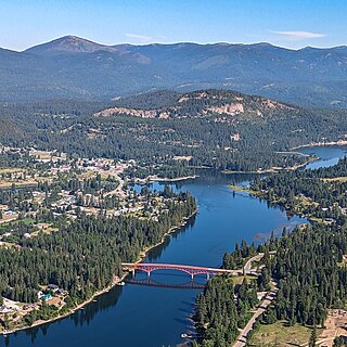
Sandpoint is the largest city in, and the county seat of, Bonner County, Idaho, United States. Its population was 9,777 as of the 2022 census.

<span class="mw-page-title-main">Bonners Ferry, Idaho</span> City in Idaho

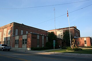
Bonners Ferry is the largest of two cities in and the county seat of Boundary County, Idaho, United States. The population was 2,543 at the 2010 census.

<span class="mw-page-title-main">Republic, Washington</span> City in Washington, United States

Republic is a city in Ferry County, Washington, United States. The population was 992 at the 2020 census. It is the county seat of Ferry County. It was the largest mining camp in the Republic Mining District, and home to the "Hot Air Line" railway.

<span class="mw-page-title-main">Cusick, Washington</span> Town in Pend Oreille County, Washington, United States

Cusick is a town in Pend Oreille County, Washington, United States. The population was 153 at the 2020 census. Cusick is the headquarters of the federally recognized Kalispel Indian Community of the Kalispel Reservation.

<span class="mw-page-title-main">Ione, Washington</span> Town in Pend Oreille County, Washington, United States

Ione is a town in Pend Oreille County, Washington, United States. The population was 428 at the 2020 census.

<span class="mw-page-title-main">Metaline, Washington</span> Town in Pend Oreille County, Washington, United States

Metaline is a town in Pend Oreille County, Washington, United States. The population was 162 at the 2020 census.

<span class="mw-page-title-main">Newport, Washington</span> City in Washington, United States

Newport is a city in and the county seat of Pend Oreille County, Washington, United States. The population was 2,114 at the 2020 census.

<span class="mw-page-title-main">Colville, Washington</span> City in Washington, United States

Colville is a city in Stevens County, Washington, United States. The population was 4,917 at the 2020 census. It is the county seat of Stevens County.

<span class="mw-page-title-main">Kettle Falls, Washington</span> City in Washington, United States

Kettle Falls is a city in Stevens County, Washington, United States, named for the nearby Kettle Falls on the Kettle River. The city itself is located on the Colville River immediately upstream from its confluence with the Columbia River. The population of the city was 1,636 at the 2020 census.

<span class="mw-page-title-main">Pend Oreille River</span> River, tributary of the Columbia

The Pend Oreille River is a tributary of the Columbia River, approximately 130 miles (209 km) long, in northern Idaho and northeastern Washington in the United States, as well as southeastern British Columbia in Canada. In its passage through British Columbia its name is spelled Pend-d'Oreille River. It drains a scenic area of the Rocky Mountains along the U.S.-Canada border on the east side of the Columbia. The river is sometimes defined as the lower part of the Clark Fork, which rises in western Montana. The river drains an area of 66,800 square kilometres (25,792 sq mi), mostly through the Clark Fork and its tributaries in western Montana and including a portion of the Flathead River in southeastern British Columbia. The full drainage basin of the river and its tributaries accounts for 43% of the entire Columbia River Basin above the confluence with the Columbia. The total area of the Pend Oreille basin is just under 10% of the entire 258,000-square-mile (670,000 km2) Columbia Basin. Box Canyon Dam is currently underway on a multimillion-dollar project for a fish ladder.

<span class="mw-page-title-main">Colville National Forest</span> U.S. National Forest in northeastern Washington state

The Colville National Forest is a U.S. National Forest located in northeastern Washington state. It is bordered on the west by the Okanogan–Wenatchee National Forest and the Kaniksu National Forest to the east. The forest also borders Little Pend Oreille National Wildlife Refuge and the Lake Roosevelt National Recreation Area.

The International Selkirk Loop is a 280-mile-long (450 km) scenic highway in the U.S. states of Idaho and Washington, as well as the Canadian province of British Columbia. The loop encircles the Selkirk Mountain Range, and offers several side trips aside from the main route. Included on the loop is the Kootenay Lake Ferry, the longest free ferry in the world. The portion of the loop in the United States has been designated an All-American Road by the United States Department of Transportation.

<span class="mw-page-title-main">Washington State Route 31</span> State highway in Pend Oreille County, Washington, US

State Route 31 (SR 31) is a Washington state highway located entirely in Pend Oreille County. The highway, which is 26.79 miles (43.11 km) long, starts at an intersection with SR 20 in Tiger and travels north to the Canada–US border north of Metaline Falls. At the border, SR 31 becomes British Columbia Highway 6 (BC 6). The route parallels the Pend Oreille River for most of its route and the primary functions of the highway is to serve and connect Tiger, Ione, Metaline and Metaline Falls with British Columbia.

<span class="mw-page-title-main">Primary State Highway 6 (Washington)</span> Former highway in Washington

Primary State Highway 6 (PSH 6) was a Washington state highway in the older primary and secondary system that existed from 1937 until 1964 in Spokane and Pend Oreille counties. The road ran from an intersection with PSH 3, U.S. Route 2 and US 395 in Spokane north to British Columbia Highway 6 (BC 6) at the Canada–US border near Metaline Falls, passing its branch route and two secondary routes.

References

  1. "2019 U.S. Gazetteer Files". United States Census Bureau. Retrieved August 7, 2020.
  2. 1 2 "Census Bureau Redistricting Data 2020". census.gov. U.S. Census Bureau. Retrieved May 3, 2022.
  3. "US Board on Geographic Names". United States Geological Survey. October 25, 2007. Retrieved January 31, 2008.
  4. Majors, Harry M. (1975). Exploring Washington. Van Winkle Publishing Co. p. 59. ISBN   978-0-918664-00-6.
  5. "Stevens County Board of Commissioners, Meetings, 1860-1913, 2005-2009 - Stvcocommmin19110503.Tif - Stevens County".
  6. Bethune, George (1890). "Mines and Minerals of Washington". Google Books. Olympia: State of Washington. pp. 82–83. Retrieved July 2, 2020.
  7. Dings, McClelland; Whitebread, Donald. "Geology and Ore Deposits of the Metaline Zinc-Lead District Pend Oreille County Washington, USGS Professional Paper 489" (PDF). USGS. pp. 56–58. Retrieved July 2, 2020.
  8. McConnel, Roger; Anderson, Roy (1968). Ridge, John (ed.). The Metaline District, Washington, in Ore deposits of the United States, 1933-1967. New York: The American Institute of Mining, Metallurgical, and Petroleum engineers, Inc. pp. 1460–1480.
  9. Willenbrock, Fred. "Pend Oreille County braces for economic losses after closure of last major rock mine". spokesman.com. The Spokesman Review. Retrieved July 2, 2020.
  10. News, Nichi Bei (June 9, 2016). "THE KAERU KID: A most righteous town". Nichi bei News.{{cite news}}: |last1= has generic name (help)
  11. "Congressional Record, Volume 161 Issue 121 (Wednesday, July 29, 2015)".
  12. "US Gazetteer files 2010". United States Census Bureau. Archived from the original on January 12, 2012. Retrieved December 19, 2012.
  13. 1 2 "Metaline Falls Quadrangle" (Map). usgs.gov. U.S. Geological Survey. 2020. Retrieved May 3, 2022.
  14. "Sullivan Lake RD". fs.usda.gov. U.S. Forest Service. Retrieved May 3, 2022.
  15. "Colville National Forest - About the Forest". fs.usda.gov. U.S. Forest Service. Retrieved May 3, 2022.
  16. "Pend Oreille Village Summary Report". nationalmap.gov. U.S. Geological Survey. Retrieved May 3, 2022.
  17. "METALINE FALLS, WASHINGTON (455317)". Western Regional Climate Center. Retrieved November 18, 2015.
  18. "U.S. Census website". United States Census Bureau. Retrieved December 19, 2012.
  19. "National Register of Historic Places – Single Property Listings – Washington" (PDF). archives.gov. National Park Service — U.S. Department of the Interior. pp. 288–291. Retrieved May 3, 2022.
  20. Scheck, Ronald. "Cutter Theater (Metaline Falls School)". spokanehistorical.org. Eastern Washington University. Retrieved May 3, 2022.
  21. "'Twin Peaks,' a 509 institution". The Spokesman Review. October 10, 2014. Retrieved June 27, 2019.
  22. "Selkirk School District". Selkirk School District. Retrieved May 3, 2022.