Middle Andaman Island

Last updated

Middle Andaman Island
Middle Andaman locale.png
Outline map of the Andaman Islands, with the location of Middle Andaman Island highlighted (in red).
India Andaman and Nicobar Islands location map.svg
Red pog.svg
Middle Andaman Island
Location within the territory of the Andaman and Nicobar Islands, and within the Bay of Bengal
Bay of Bengal location map simple.svg
Red pog.svg
Middle Andaman Island
Middle Andaman Island (Bay of Bengal)
Geography
Location Bay of Bengal
Coordinates 12°30′00″N92°50′00″E / 12.5°N 92.833333°E / 12.5; 92.833333
Archipelago Andaman Islands
Adjacent to Indian Ocean
Total islands1
Major islands
  • Middle Andaman Island
Area1,523 km2 (588 sq mi) [1]
Length70 km (43 mi)
Width28 km (17.4 mi)
Coastline272 km (169 mi)
Highest elevation512 m (1680 ft) [2]
Highest point Mount Diavolo
Administration
Flag of India.svg  India
District North and Middle Andaman
Island group Andaman Islands
Island sub-group Great Andaman
Taluk Multiple
Largest settlement Rangat Metropolitan (pop 10,000)
Demographics
Population55,632 (2011)Only middle andaman villages from the 2011 census
Pop. density36.5/km2 (94.5/sq mi)
Ethnic groups Hindu, Andamanese, Jarawa
Additional information
Time zone
PIN 744202 [3]
Telephone code031927 [4]
ISO code IN-AN-00 [5]
Official website www.and.nic.in
Literacy84.4%
Avg. summer temperature30.2 °C (86.4 °F)
Avg. winter temperature23.0 °C (73.4 °F)
Sex ratio 1.2/
Census Code35.639.0004
Official Languages Hindi, English

Middle Andaman Island is an island of the Andaman Islands. It belongs to the North and Middle Andaman administrative district, part of the Indian union territory of Andaman and Nicobar Islands. [6]

Contents

Geography

The island belongs to the Great Andaman Chain and is located 73 km (45 mi) north from Port Blair. It is the central island of the Great Andaman archipelago of India, with a total area of 1,536 km2. Middle Andaman is separated from North Andaman Island by Austen Strait, and from Baratang Island at the south by Homfray's Strait, both shallow and narrow channels, a few hundred metres wide; and from Interview Island at its west by the navigable Interview Passage. [7]

The island's coastline was inundated by the tsunami resulting from the 26 December 2004 Indian Ocean earthquake, though the effect was far less severe when compared with other Islands of Andaman and Nicobar Islands.

Administration

Politically, Middle Andaman Island, is part of Mayabunder and Rangat Tehsils. [8] [9] [10]

Demographics

Population of Middle Andaman consists of Bengali, Tamil and Keralite settlers. The island is also home to many of the indigenous Jarawa people. The main occupation of the inhabitants is farming and Agriculture.

Middle Andaman's main towns (Metro population in brackets) are Rangat (10,000), Mayabunder (5,565), Bakultala (4,454), Nimbutala (3,063), and Kadamtala (3,008).

According to the 2011 census of India, the Island has x households. The effective literacy rate (i.e. the literacy rate of population excluding children aged 6 and below) is 76%. [11]

Demographics (2011 Census) [11]
TotalMaleFemale
Population556322876726865
Children aged below 6 years206510391026
Scheduled caste 000
Scheduled tribe 333
Literates422942294619348
Workers (all)220
Main workers (total)220

Tourism

The island hosts immaculate waterfalls, and pretty beaches. Adventurous fun such as Island camping, trekking, Scuba diving, snorkeling, and other exciting water sports offer you chance to indulge in real pleasure. [12]

Related Research Articles

<span class="mw-page-title-main">South Andaman Island</span>

South Andaman Island is the southernmost island of the Great Andaman and is home to the majority of the population of the Andaman Islands. It belongs to the South Andaman administrative district, part of the Indian union territory of Andaman and Nicobar Islands. It is the location of Port Blair, capital of the Andaman and Nicobar Islands.

Baratang Island is an island of the Andaman Islands. It belongs to the North and Middle Andaman administrative district, part of the Indian union territory of Andaman and Nicobar Islands. The island lies 150 km (93 mi) north of Port Blair.

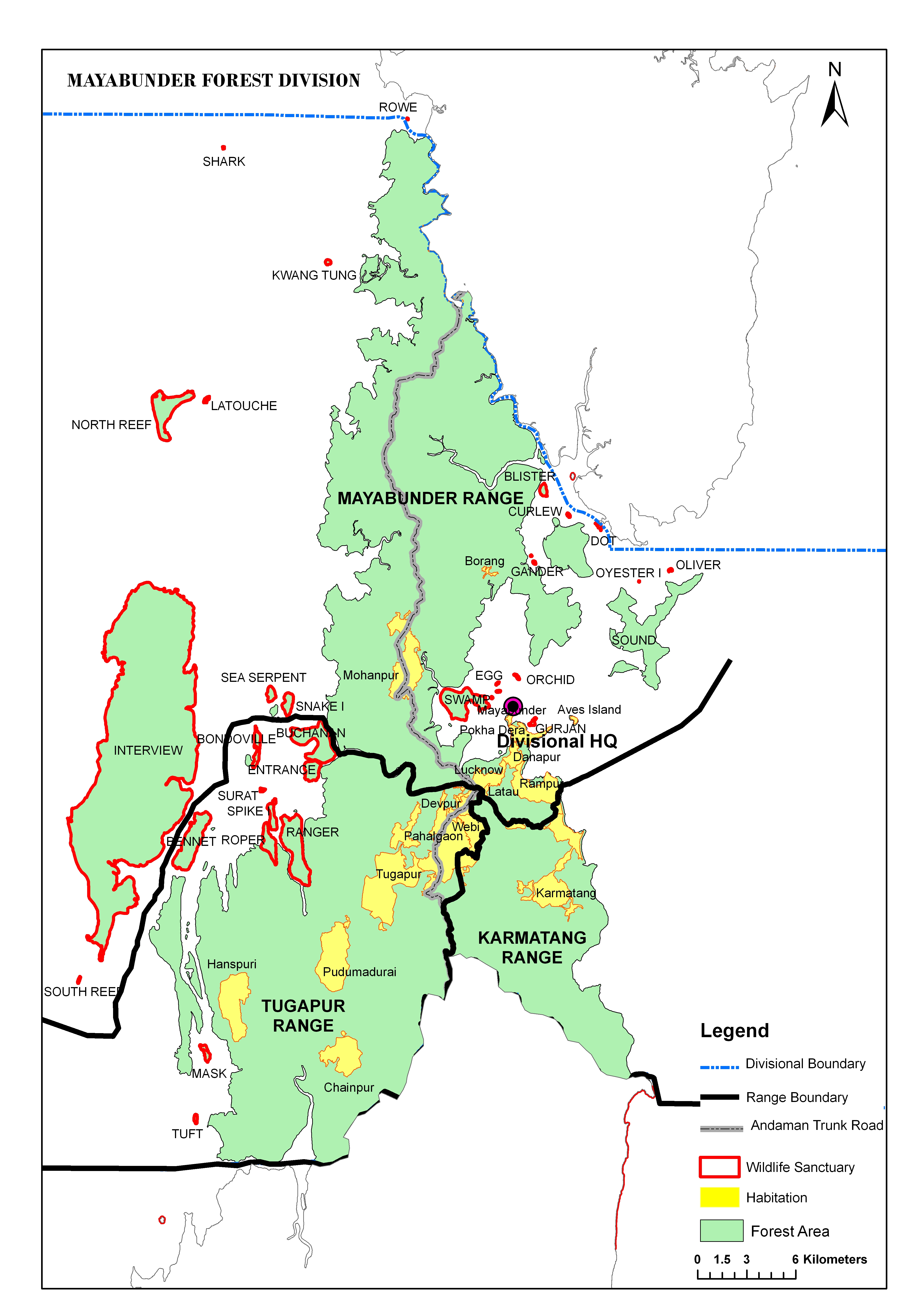
Rangat is a town on the Middle Andaman Island, Andaman Archipelago. It is also one of the three counties (tehsils) administrative divisions of the North and Middle Andaman district, in the Andaman and Nicobar Islands union territory of India. Its population, according to the 2001 Census of India, was 38,824 people, mainly of Bengalis and Tamils.

Interview Island is an island of the Andaman Islands. It belongs to the North and Middle Andaman administrative district, part of the Indian union territory of Andaman and Nicobar Islands. It lies 125 km (78 mi) north of Port Blair.

Strait Island is an island of the Andaman Islands. It belongs to the North and Middle Andaman administrative district, part of the Indian union territory of Andaman and Nicobar Islands. The island lies 63 km (39 mi) north from Port Blair.

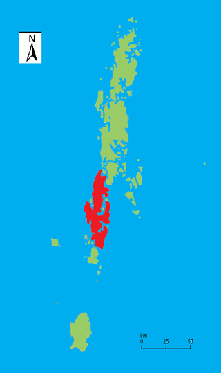
North and Middle Andaman district is one of the 3 districts of the Indian Union Territory of Andaman and Nicobar Islands located in the Bay of Bengal. Mayabunder town is the district headquarters. The area covered by this district is 3251.85 km2.

Bluff Island is an island of the Andaman Islands. It belongs to the North and Middle Andaman administrative district, part of the Indian union territory of Andaman and Nicobar Islands. The island lies 64 km (40 mi) north from Port Blair.

Landfall Island is the northernmost island of the Indian union territory of Andaman and Nicobar Islands. It belongs to the territory's North and Middle Andaman administrative district. The island lies 220 km (137 mi) north of Port Blair, and is situated 300 km (186 mi) south of Myanmar. It is home to the Kari tribe.

East Island is an island of the Andaman Islands. It belongs to the North and Middle Andaman administrative district, part of the Indian union territory of Andaman and Nicobar Islands. The island is located 220 km (137 mi) north from Port Blair.

Smith Island is an island of the Andaman Islands. It belongs to the North and Middle Andaman administrative district, part of the Indian union territory of Andaman and Nicobar Islands. The island lies 298 km (185 mi) north of Port Blair.

Stewart Island is an island of the Andaman Islands. It belongs to the North and Middle Andaman administrative district, part of the Indian union territory of Andaman and Nicobar Islands. The island lies 150 km (93 mi) north of Port Blair. Its population only consists of two people.

Aves Island is an island of the Andaman Islands. It belongs to the North and Middle Andaman administrative district, part of the Indian union territory of Andaman and Nicobar Islands. The island lies 140 km (87 mi) north from Port Blair.

Sound Island is an island of the Andaman Islands. It belongs to the North and Middle Andaman administrative district, part of the Indian union territory of Andaman and Nicobar Islands. The island lies 144 km (89 mi) north from Port Blair.

Bennett Island is an island of the Andaman Islands. It belongs to the North and Middle Andaman administrative district, part of the Indian union territory of Andaman and Nicobar Islands. The island lies 130 km (81 mi) north from Port Blair.

Anderson Island is an island of the Andaman Islands. It belongs to the North and Middle Andaman administrative district, part of the Indian union territory of Andaman and Nicobar Islands. The island is located 117 km (73 mi) north from Port Blair.

Murga Island is an island of the Andaman Islands. It belongs to the North and Middle Andaman administrative district, part of the Indian union territory of Andaman and Nicobar Islands. The island lies 117 km (73 mi) north from Port Blair.

The Interview Islands is a group of islands located in Austin Harbour and Interview sound. These islands belong to the Andaman Islands. They belong to the North and Middle Andaman administrative district, part of the Indian union territory of Andaman and Nicobar Islands.

Spike Island is an island of the Andaman Islands. It belongs to the North and Middle Andaman administrative district, part of the Indian union territory of Andaman and Nicobar Islands. The island lies 63 km (39 mi) north from Port Blair.

West Baratang Group are an island group of the Andaman Islands, located west of Baratang Island.

North Passage Island is an island of the Andaman Islands. It belongs to the North and Middle Andaman administrative district, part of the Indian union territory of Andaman and Nicobar Islands. The island lies 80 km (50 mi) north from Port Blair.

References

  1. "Islandwise Area and Population - 2011 Census" (PDF). Government of Andaman. Archived from the original (PDF) on 28 August 2017. Retrieved 28 September 2016.
  2. Sailing Directions (Enroute), Pub. 173: India and the Bay of Bengal (PDF). Sailing Directions . United States National Geospatial-Intelligence Agency. 2017. p. 281.
  3. "A&N Islands - Pincodes". 22 September 2016. Archived from the original on 23 March 2014. Retrieved 22 September 2016.{{cite web}}: CS1 maint: bot: original URL status unknown (link)
  4. "STD Codes of Andaman and Nicobar". allcodesindia.in. Retrieved 23 September 2016.
  5. Registration Plate Numbers added to ISO Code
  6. "Village Code Directory: Andaman & Nicobar Islands" (PDF). Census of India. Retrieved 16 January 2011.
  7. Edgar Thorpe, Showick Thorpe (2011) The Pearson CSAT Manual 2011 . Accessed on 2012-07-26
  8. "DEMOGRAPHIC – A&N ISLANDS" (PDF). andssw1.and.nic.in. Archived from the original (PDF) on 28 August 2017. Retrieved 23 September 2016.
  9. "north part map". Archived from the original on 10 May 2017. Retrieved 17 October 2016.
  10. "south part map". Archived from the original on 10 May 2017. Retrieved 17 October 2016.
  11. 1 2 "District Census Handbook - Andaman & Nicobar Islands" (PDF). 2011 Census of India . Directorate of Census Operations, Andaman & Nicobar Islands. Archived from the original (PDF) on 1 August 2015. Retrieved 21 July 2015.
  12. "Rangat Island in Andaman and Nicobar, Information of Rangat Island in Andaman". www.indiatravelnext.com. Archived from the original on 20 May 2013. Retrieved 13 January 2022.