
The Schuylkill River is a river running northwest to southeast in eastern Pennsylvania. The river was improved by navigations into the Schuylkill Canal, and several of its tributaries drain major parts of Pennsylvania's Coal Region. It flows for 135 miles (217 km) from Pottsville to Philadelphia, where it joins the Delaware River as one of its largest tributaries.

Wissahickon Creek is a tributary of the Schuylkill River in Montgomery and Philadelphia Counties, Pennsylvania.

Rock Creek is a tributary of the Potomac River, in the United States, that empties into the Atlantic Ocean via the Chesapeake Bay. The 32.6-mile (52.5 km) creek drains about 76.5 square miles (198 km2). Its final quarter-mile is affected by tides.

University City is the easternmost portion of West Philadelphia, encompassing several Philadelphia universities. It is situated directly across the Schuylkill River from Center City.

Cobbs Creek is an 11.8-mile-long (19.0 km) tributary of Darby Creek in Delaware County, Pennsylvania, in the United States. It forms an approximate border between Montgomery County and Delaware County. After Cobbs Creek passes underneath Township Line Road, it forms the border between Philadelphia County and Delaware County. It runs directly through the two sides of Mount Moriah Cemetery which spans the border of Southwest Philadelphia and Yeadon, Pennsylvania. It later joins Darby Creek before flowing into the Delaware River.

Grays Ferry, also known as Gray's Ferry, is a neighborhood in South Philadelphia, Pennsylvania, United States, bounded (roughly) by 25th Street on the east, the Schuylkill River on the west, Vare Avenue on the south, and Grays Ferry Avenue on the north. The section of this neighborhood west of 34th Street is also known as Forgotten Bottom. Grays Ferry shares borders with Southwest Center City to the North, Point Breeze to the East, and Girard Estate to the South. Gray’s Ferry is across from where Mill Creek debouches at about 43rd street. Historically, Grays Ferry was one of the largest enclaves of Irish Americans in the city, and while there are still many Irish left, it is now home to a significant African American population.

Poquessing Creek is a 10.3-mile-long (16.6 km) creek, a right tributary of the Delaware River, that forms the boundary between Philadelphia and Bensalem Township, which borders it to the northeast along the Delaware. It has defined this boundary between Bucks and Philadelphia counties since 1682.

Frankford Creek is a minor tributary of the Delaware River in southeast Pennsylvania. It derived its name from the nearby town of Frankford, Philadelphia County. The stream originates as Tookany Creek at Hill Crest in Cheltenham Township and meanders eastward, then southeastward, throughout Cheltenham Township, until a sharp bend near the Philadelphia border at Lawncrest, where the place names Toxony and Tookany were used in historic times; the stream is still known as Tookany Creek in this region, where it flows southwest. Turning south into Philadelphia at the crotch of Philadelphia's V-shaped border, the creek is called Tacony Creek; from here southward, it is considered the informal boundary separating Northeast Philadelphia from the rest of the city. The Philadelphia neighborhoods of Olney and Feltonville lie on the western side of the stream in this area while Northwood, Lawncrest, Summerdale, and Frankford lie on the eastern side. It continues to be called the Tacony at least until the smaller Wingohocking Creek merges with it in Juniata Park, within the city-owned golf course. Beyond Castor Avenue it is known as Frankford Creek until the stream's confluence with the Delaware River in the Bridesburg neighborhood of Philadelphia. The section of stream known as Frankford Creek is 3.1 miles (5.0 km) long, and the upstream section known as Tacony Creek, from Hill Crest, is 11.1 miles (17.9 km) long.
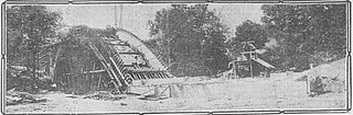
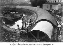
Wingohocking Creek was once a major tributary of another Philadelphia, Pennsylvania stream, Frankford Creek, which flows into the Delaware River. Frankford Creek was formed by the confluence of Wingohocking Creek and Tacony Creek. Since Wingohocking Creek is now obliterated, having been piped underground in the late 19th century, it can be confusing to look at a modern map, which shows Tacony Creek suddenly changing names "in the middle of the stream," so to speak, and becoming Frankford Creek. The point at which the name changes is near the present intersection of I and Ramona Streets, where the Wingohocking once joined the Tacony to form the Frankford Creek. What was once a major stream and the site of many mills and factories has been completely wiped off the map—all but the city's sewer maps, that is. The outlet of the Wingohocking Sewer is the largest in the Philadelphia sewer system, about 24 feet (7.3 m) high. It is visible from various points in the Juniata neighborhood and the adjoining golf course.
Paper Mill Run, also known as Monoshone Creek, is a small tributary of Wissahickon Creek that is located in Philadelphia, Pennsylvania, USA. Its watershed includes parts of the Mount Airy and Germantown neighborhoods of Philadelphia.
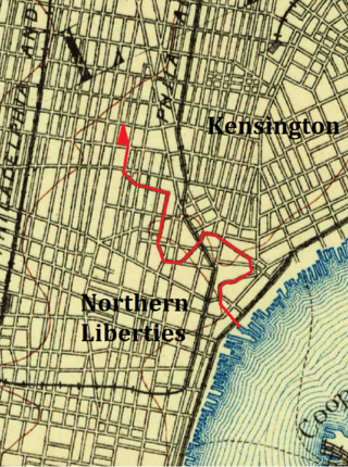
The Cohocksink Creek was formerly a stream running between what are now the Philadelphia neighborhoods of Northern Liberties and Kensington. It was a tributary of the Delaware River. Its name, spelled various ways, is said to come from a Lenape word for "pine lands". Alternate names included Stacey's Creek. The creek arose at the confluence of two smaller streams in a pond around the present-day intersection of Sixth and Thompson streets. For centuries, Cohocksink Creek has often been confused with Cohoquinoque Creek, a culverted stream about a mile to the south.

Daylighting is the opening up and restoration of a previously buried watercourse, one which had at some point been diverted below ground. Typically, the rationale behind returning the riparian environment of a stream, wash, or river to a more natural above-ground state is to reduce runoff, create habitat for species in need of it, or improve an area's aesthetics. In the United Kingdom, the practice is also known as deculverting.

Mill Creek is a neighborhood in the West Philadelphia section of Philadelphia, Pennsylvania, United States. It sits between 44th and 52nd Streets, north of Market Street and south of Girard Avenue. It was named for Philadelphia's Mill Creek, which was buried during 19th-century sewer system improvements. In 1961, the sewer collapsed, taking homes with it.

Maiden Creek is a 20.3-mile-long (32.7 km) tributary of the Schuylkill River in Berks County, Pennsylvania. The name "Maiden" is an English translation of the Native American word Ontelaunee. Maiden Creek is formed by the confluence of Ontelaunee and Kistler creeks in the community of Kempton. The tributary Sacony Creek joins at the community of Virginville.

Gray's Ferry Bridge has been the formal or informal name of several floating bridges and four permanent ones that have carried highway and rail traffic over the Schuylkill River in Philadelphia. The bridge today is a four-lane divided highway bridge, built in 1976, that carries Grays Ferry Avenue from the Grays Ferry neighborhood on the east bank, over the river and the Northeast Corridor railroad tracks, to the Southwest Philadelphia neighborhood of Kingsessing.
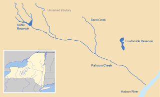
Patroon Creek is a stream in Albany County, New York, United States and is a tributary of the Hudson River which flows south to New York Harbor and the Atlantic Ocean. The creek's source is Rensselaer Lake in the western section of the city of Albany. Patroon Creek received its name from the patroon of Rensselaerswyck.
Piney Branch is a tributary of Rock Creek in Washington, D.C. It is the largest tributary located entirely within the Washington city limits. It is spanned by the 16th Street Bridge, the country's first parabolic arch bridge.

The Philadelphia Water Department is the public water utility for the City of Philadelphia. PWD provides integrated potable water, wastewater, and stormwater services for Philadelphia and some communities in Bucks, Delaware and Montgomery counties. PWD is a municipal agency of the City of Philadelphia, and is seated in rented space at the Jefferson Tower in the Market East area of Center City, Philadelphia.

The Dock Street Market was Philadelphia's central wholesale produce market from 1870 until its closure in 1959 and relocation to the Food Distribution Center in South Philadelphia. The Dock Street Market was located on Dock Street in Society Hill. Dock Street is three blocks long, and runs from Sansom Street to Spruce Street, and between Third and Front streets. The market was busiest between midnight and eight in the morning when produce was loaded and offloaded between delivery trucks and warehouses.
Mingo Creek is a tributary of the Schuylkill River between the Eastwick neighborhood and Philadelphia International Airport, in the United States.