Millersburg, Indiana

Last updated

Millersburg, Indiana
Elkhart County Indiana Incorporated and Unincorporated areas Millersburg Highlighted 1849536.svg
Location of Millersburg in Elkhart County, Indiana.
Coordinates: 41°31′40″N85°41′47″W / 41.52778°N 85.69639°W / 41.52778; -85.69639
Country United States
State Indiana
County Elkhart
Township Clinton, Benton
Area
[1]
  Total0.65 sq mi (1.67 km2)
  Land0.65 sq mi (1.67 km2)
  Water0.00 sq mi (0.00 km2)
Elevation
[2]
883 ft (269 m)
Population
 (2020)
  Total957
  Density1,481.42/sq mi (572.01/km2)
Time zone UTC-5 (Eastern (EST))
  Summer (DST) UTC-4 (EDT)
ZIP code
46543
Area code 574
FIPS code 18-49536 [3]
GNIS feature ID2396764 [2]
Website Website

Millersburg is a town in Clinton and Benton townships, Elkhart County, Indiana, United States. The population was 903 at the 2010 census.

Contents

History

Millersburg was platted in 1855. [4] It was named for its founder, Solomon Miller. [5]

Geography

Millersburg is located at 41°31′30″N85°41′50″W / 41.52500°N 85.69722°W / 41.52500; -85.69722 (41.524866, -85.697137). [6]

According to the 2010 census, Millersburg has a total area of 0.54 square miles (1.40 km2), all land. [7]

Demographics

Historical population
CensusPop.Note
1870 52
1880 449763.5%
1890 394−12.2%
1900 48122.1%
1910 428−11.0%
1920 385−10.0%
1930 344−10.6%
1940 38411.6%
1950 43713.8%
1960 48911.9%
1970 61826.4%
1980 80930.9%
1990 8545.6%
2000 8681.6%
2010 9034.0%
2020 9576.0%
U.S. Decennial Census [8]

2010 census

As of the census [9] of 2010, there were 903 people, 324 households, and 244 families living in the town. The population density was 1,672.2 inhabitants per square mile (645.6/km2). There were 345 housing units at an average density of 638.9 per square mile (246.7/km2). The racial makeup of the town was 97.0% White, 0.6% African American, 0.9% Native American, 1.1% from other races, and 0.4% from two or more races. Hispanic or Latino of any race were 4.4% of the population.

There were 324 households, of which 42.9% had children under the age of 18 living with them, 57.1% were married couples living together, 13.9% had a female householder with no husband present, 4.3% had a male householder with no wife present, and 24.7% were non-families. 18.2% of all households were made up of individuals, and 7.1% had someone living alone who was 65 years of age or older. The average household size was 2.79 and the average family size was 3.22.

The median age in the town was 33.1 years. 30.1% of residents were under the age of 18; 8.6% were between the ages of 18 and 24; 29.8% were from 25 to 44; 22.3% were from 45 to 64; and 9.2% were 65 years of age or older. The gender makeup of the town was 51.1% male and 48.9% female.

2000 census

As of the census [3] of 2000, there were 868 people, 310 households, and 249 families living in the town. The population density was 1,646.6 inhabitants per square mile (635.8/km2). There were 324 housing units at an average density of 614.6 per square mile (237.3/km2). The racial makeup of the town was 99.19% White, 0.12% African American, 0.35% from other races, and 0.35% from two or more races. Hispanic or Latino of any race were 1.27% of the population.

There were 310 households, out of which 45.8% had children under the age of 18 living with them, 62.6% were married couples living together, 11.6% had a female householder with no husband present, and 19.4% were non-families. 14.5% of all households were made up of individuals, and 4.8% had someone living alone who was 65 years of age or older. The average household size was 2.80 and the average family size was 3.06.

In the town, the population was spread out, with 33.1% under the age of 18, 7.9% from 18 to 24, 31.0% from 25 to 44, 19.4% from 45 to 64, and 8.6% who were 65 years of age or older. The median age was 30 years. For every 100 females, there were 102.3 males. For every 100 females age 18 and over, there were 102.4 males.

The median income for a household in the town was $43,750, and the median income for a family was $44,250. Males had a median income of $36,083 versus $25,179 for females. The per capita income for the town was $19,700. About 2.7% of families and 4.0% of the population were below the poverty line, including 5.3% of those under age 18 and 5.1% of those age 65 or over.

School System

Millersburg Elementary School

Millersburg, just like New Paris Elementary, used to be a K-12 school until Fairfield Junior-Senior High School opened up in 1968. Millersburg is a predominantly Amish elementary school. In 1999, a new elementary school was created, it was called, Benton Elementary School, and it would serve rural areas throughout New Paris and Millersburg. In 2008, Fairfield Community Schools had a board meeting upon the issue of the decreasing number of students at Millersburg Elementary, and the rapid growth of Benton Elementary. Fairfield Community Schools ruled that Millersburg would serve a wider area of land to raise the number of students, and keep Benton from overflowing. This eventually fell through and Millersburg got no new students from Benton.

Related Research Articles

<span class="mw-page-title-main">Elkhart County, Indiana</span> County in Indiana, United States

Elkhart County is a county located in the U.S. state of Indiana. As of 2020, the county's population was 207,047. The county seat is Goshen. Elkhart County is part of the Elkhart-Goshen Metropolitan Statistical Area, which in turn is part of the South Bend-Elkhart-Mishawaka Combined Statistical Area. It is also considered part of the broader region of Northern Indiana known as Michiana, and is 20 miles (32 km) east of South Bend, Indiana, 110 miles (180 km) east of Chicago, Illinois, and 150 miles (240 km) north of Indianapolis, Indiana. The area is referred to by locals as the recreation vehicle (RV) capital of the world and is known for its sizable Amish and Old Order Mennonite population.

<span class="mw-page-title-main">Garfield, Arkansas</span> Town in Arkansas, United States

Garfield is a town in Benton County, Arkansas, United States. The population was 593 at the 2020 census. It is part of the Northwest Arkansas region.

<span class="mw-page-title-main">Earl Park, Indiana</span> Town in Indiana, United States

Earl Park is a town in Richland Township, Benton County, Indiana, United States. The population was 348 at the 2010 census. It is part of the Lafayette, Indiana Metropolitan Statistical Area.

<span class="mw-page-title-main">Fowler, Indiana</span> Town in Indiana, United States

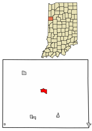
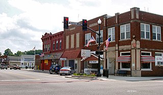
Fowler is a town in, and county seat of Center Township, Benton County, Indiana, United States. The population was 2,337 at the 2020 census. It is part of the Lafayette, Indiana Metropolitan Statistical Area.

<span class="mw-page-title-main">Otterbein, Indiana</span> Town in Indiana, United States

Otterbein is a town in Shelby Township, Tippecanoe County and Bolivar Township, Benton County, Indiana, named for William Otterbein Brown who donated land for the town. As of the 2010 census, its population was 1,262.

<span class="mw-page-title-main">Bristol, Indiana</span> Town in Indiana, United States

Bristol is a town in Washington Township, Elkhart County, Indiana, United States. The population was 1,602 at the 2010 census.

<span class="mw-page-title-main">Dunlap, Indiana</span> Census-designated place in Indiana, United States

Dunlap is a census-designated place (CDP) in Elkhart County, Indiana, United States. The population was 6,235 at the 2010 census. Once a small farming community, by the 1980s it had become a suburb of Elkhart and Goshen, Indiana. Most of the town was destroyed by two violent F4 tornadoes during the Palm Sunday Tornado Outbreak on April 11, 1965.

<span class="mw-page-title-main">New Paris, Indiana</span> Census-designated place in Indiana, United States

New Paris is a census-designated place (CDP) in Elkhart County, Indiana, United States. The population was 1,494 at the 2010 census.

<span class="mw-page-title-main">Simonton Lake, Indiana</span> Census-designated place in Indiana, United States

Simonton Lake is a census-designated place (CDP) in Elkhart County, Indiana, United States. The population was 4,678 at the 2010 census.

<span class="mw-page-title-main">Wakarusa, Indiana</span> Town in Indiana, United States

Wakarusa is a town in Harrison and Olive townships in Elkhart County, Indiana, United States. The population was 1,758 at the 2010 census.

<span class="mw-page-title-main">Somerville, Indiana</span> Town in Indiana, United States

Somerville is a town in Barton Township, Gibson County, Indiana, United States. The population was 293 at the 2010 census, making it the third-smallest community in the county.

<span class="mw-page-title-main">New Whiteland, Indiana</span> Town in Indiana, United States

New Whiteland is a town in Pleasant Township, Johnson County, Indiana, United States. The population was 5,550 at the 2020 census.

<span class="mw-page-title-main">Kingsford Heights, Indiana</span> Town in Indiana, United States

Kingsford Heights is a town in Union Township, LaPorte County, Indiana, United States. The population was 1,335 at the 2020 census. It is included in the Michigan City, Indiana-La Porte, Indiana Metropolitan Statistical Area. Also known as "Victory City," the town was built by the United States government for workers that worked in the Kingsbury Ordnance Plant, an ammunitions plant that served the US during World War II and later the Korean War.

<span class="mw-page-title-main">Summitville, Indiana</span> Town in Indiana, United States

Summitville is a town in Van Buren Township, Madison County, Indiana, United States. It is part of the Indianapolis–Carmel–Anderson metropolitan statistical area. The population was 989 at the 2020 census.

<span class="mw-page-title-main">Osceola, Indiana</span> Town in Indiana, United States

Osceola is a town in Penn Township, St. Joseph County, in the U.S. state of Indiana. The population was 2,463 at the 2010 Census. It is part of the South Bend–Mishawaka, IN-MI, Metropolitan Statistical Area.

<span class="mw-page-title-main">Millersburg, Iowa</span> City in Iowa, United States

Millersburg is a city in Iowa County, Iowa, United States. The population was 135 at the time of the 2020 census.

<span class="mw-page-title-main">Elkhart, Iowa</span> City in Iowa, United States

Elkhart is a city in Polk County, Iowa, United States. The population was 882 at the time of the 2020 census. It is part of the Des Moines–West Des Moines Metropolitan Statistical Area.

<span class="mw-page-title-main">Benton, Kansas</span> City in Butler County, Kansas

Benton is a city in Butler County, Kansas, United States. As of the 2020 census, the population of the city was 943.

<span class="mw-page-title-main">Benton, Missouri</span> City in Missouri, United States

Benton is a city in Scott County, Missouri, United States. The population was 863 at the 2010 census. It is the county seat of Scott County.

<span class="mw-page-title-main">Millersburg, Ohio</span> Village in Ohio, United States

Millersburg is a village and the county seat of Holmes County, Ohio, United States. Located 66 miles (106 km) south of Cleveland, it is in the heart of Ohio's Amish Country and is part of a large regional tourism industry. The population was 3,151 at the 2020 census. Holmes County Airport, located two miles southwest of Millersburg, serves the county.

References

  1. "2020 U.S. Gazetteer Files". United States Census Bureau. Retrieved March 16, 2022.
  2. 1 2 U.S. Geological Survey Geographic Names Information System: Millersburg, Indiana
  3. 1 2 "U.S. Census website". United States Census Bureau . Retrieved January 31, 2008.
  4. Deahl, Anthony (1905). A Twentieth Century History and Biographical Record of Elkhart County, Indiana. Lewis Publishing Company. pp.  105.
  5. History of Elkhart County, Indiana. Chas. C. Chapman Co. 1881. pp.  695.
  6. "US Gazetteer files: 2010, 2000, and 1990". United States Census Bureau. February 12, 2011. Retrieved April 23, 2011.
  7. "G001 - Geographic Identifiers - 2010 Census Summary File 1". United States Census Bureau. Archived from the original on February 13, 2020. Retrieved July 17, 2015.
  8. "Census of Population and Housing". Census.gov. Retrieved June 4, 2015.
  9. "U.S. Census website". United States Census Bureau . Retrieved December 11, 2012.