Millhousen, Indiana | |
---|---|
Coordinates: 39°12′43″N85°26′03″W / 39.21194°N 85.43417°W | |
Country | United States |
State | Indiana |
County | Decatur |
Township | Marion |
Established | 1834 |
Area | |
• Total | 1.01 sq mi (2.62 km2) |
• Land | 1.01 sq mi (2.62 km2) |
• Water | 0.00 sq mi (0.00 km2) |
Elevation | 902 ft (275 m) |
Population (2020) | |
• Total | 149 |
• Density | 147.52/sq mi (56.97/km2) |
Time zone | UTC-5 (Eastern (EST)) |
• Summer (DST) | UTC-4 (EDT) |
ZIP code | 47261 |
Area code | 812 |
FIPS code | 18-49662 [3] |
GNIS feature ID | 2396765 [2] |
Website | millhousen |
Millhousen is a town in Marion Township, Decatur County, Indiana, United States. The population was 149 at the 2020 census.
Millhousen was platted in 1858, having been settled by a colony of German Catholics. It was named for a town of the same name in Germany. [4] Millhousen is perhaps best known for being the home of the Immaculate Conception Church, one of only four Roman Catholic churches in Decatur County.
According to the 2010 census, Millhousen has a total area of 1.01 square miles (2.62 km2), all land. [5]
Census | Pop. | Note | %± |
---|---|---|---|
1880 | 331 | — | |
1890 | 224 | −32.3% | |
1900 | 265 | 18.3% | |
1910 | 211 | −20.4% | |
1920 | 165 | −21.8% | |
1930 | 162 | −1.8% | |
1940 | 180 | 11.1% | |
1950 | 184 | 2.2% | |
1960 | 212 | 15.2% | |
1970 | 252 | 18.9% | |
1980 | 214 | −15.1% | |
1990 | 151 | −29.4% | |
2000 | 136 | −9.9% | |
2010 | 127 | −6.6% | |
2020 | 149 | 17.3% | |
U.S. Decennial Census [6] |
As of the census [7] of 2010, there were 127 people, 52 households, and 31 families living in the town. The population density was 125.7 inhabitants per square mile (48.5/km2). There were 60 housing units at an average density of 59.4 per square mile (22.9/km2). The racial makeup of the town was 99.2% White and 0.8% from two or more races.
There were 52 households, of which 32.7% had children under the age of 18 living with them, 48.1% were married couples living together, 5.8% had a female householder with no husband present, 5.8% had a male householder with no wife present, and 40.4% were non-families. 36.5% of all households were made up of individuals, and 17.3% had someone living alone who was 65 years of age or older. The average household size was 2.44 and the average family size was 3.10.
The median age in the town was 32.9 years. 28.3% of residents were under the age of 18; 5.6% were between the ages of 18 and 24; 31.5% were from 25 to 44; 22.9% were from 45 to 64; and 11.8% were 65 years of age or older. The gender makeup of the town was 49.6% male and 50.4% female.
As of the census [3] of 2000, there were 136 people, 55 households, and 38 families living in the town. The population density was 134.3 inhabitants per square mile (51.9/km2). There were 63 housing units at an average density of 62.2 per square mile (24.0/km2). The racial makeup of the town was 100.00% White.
There were 55 households, out of which 30.9% had children under the age of 18 living with them, 60.0% were married couples living together, 3.6% had a female householder with no husband present, and 29.1% were non-families. 25.5% of all households were made up of individuals, and 20.0% had someone living alone who was 65 years of age or older. The average household size was 2.47 and the average family size was 3.00.
In the town, the population was spread out, with 24.3% under the age of 18, 9.6% from 18 to 24, 26.5% from 25 to 44, 19.1% from 45 to 64, and 20.6% who were 65 years of age or older. The median age was 34 years. For every 100 females, there were 100.0 males. For every 100 females age 18 and over, there were 94.3 males.
The median income for a household in the town was $39,250, and the median income for a family was $41,250. Males had a median income of $33,333 versus $33,333 for females. The per capita income for the town was $17,646. There were 5.0% of families and 2.7% of the population living below the poverty line, including no under eighteens and 12.5% of those over 64.
Decatur is a city, in Benton County, Arkansas, United States. The population was 1,773 at the 2020 census. It is part of the Northwest Arkansas region. This town is named after Commodore Stephen Decatur, Jr.
Monroe is a town in Washington and Monroe townships, Adams County, Indiana, United States. The population of the town was 945 residents at the 2019 census. Adams Central Community Schools is located in Monroe.
Milltown is a town in Whiskey Run Township in Crawford County, Indiana and in Blue River and Spencer townships in Harrison County. The population was 818 at the time of the 2010 census.
West Harrison is a town in Harrison Township, Dearborn County, Indiana, United States. The population was 289 at the 2010 census.
Milford is an unincorporated community in Decatur County, Indiana, United States. The population was 121 at the 2000 census. On August 4, 2007, Milford was dissolved into an unincorporated community.
St. Paul or Saint Paul is a small town on the border of Decatur and Shelby counties in the U.S. state of Indiana. The population was 1,031 at the 2010 census.
Westport is a town located in Sand Creek Township, Decatur County, Indiana. The population was 1,379 at the 2010 census. A covered bridge, built in 1880, is located about 1.5 miles east of town.
Kingman is a town in Millcreek Township, Fountain County, Indiana, United States. The population was 511 at the 2010 census.
Converse is a town in Jackson Township, Miami County, and Richland Township, Grant County, in the U.S. state of Indiana. The population was 1,161 at the 2020 census.
McCordsville is a town in Vernon Township, Hancock County, Indiana, United States. The town is a fast-growing suburb of Indianapolis with an estimated population of 8,592 in 2020.
Medora is a town in Carr Township, Jackson County, Indiana, United States. The population was 693 at the 2010 census.
Kingsbury is a town in Washington Township, LaPorte County, Indiana, just northwest of the intersection of U.S. Route 35 and U.S. Route 6. The town was founded in 1835 and incorporated on March 3, 1941. During 1940 - 1941, the Kingsbury Ordnance Plant (KOP) was built for use during World War II. The plant closed after the war but reopened during the Korean War, closing permanently in 1959. The population was 242 at the 2010 census. It is included in the Michigan City, Indiana-La Porte, Indiana Metropolitan Statistical Area. The town has its own fire department, KVFD, and a Greek revival style First Baptist church built in 1851 with its own graveyard and Winchell Cemetery.
Parker City is a town in Monroe Township, Randolph County, in the U.S. state of Indiana. The population was 1,419 at the 2010 census.
Hardinsburg is a census-designated place in Posey Township, Washington County, in the U.S. state of Indiana. The population was 222 at the 2020 census.
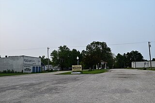
Weldon is a city in Clarke and Decatur counties of the U.S. state of Iowa. The population was 136 at the time of the 2020 census.
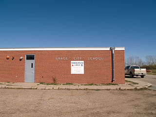
Grace City is a city in Foster County, North Dakota, United States. The population was 53 at the 2020 census. Grace City was founded in 1910.
Kirby is a village in Wyandot County, Ohio, United States. The population was 120 at the 2020 census.
Orienta is a town in Bayfield County, Wisconsin, United States. The population was 122 at the 2010 census.
Meridian Hills is a town in Washington Township, Marion County, Indiana, about 8 miles (13 km) north of downtown Indianapolis. It had a population of 1,774 at the 2020 census, up from 1,616 in 2010.
New Point is a town in Salt Creek Township, Decatur County, Indiana, United States. The population was 331 at the 2010 census.