Miqan Wetland

Last updated
Miqan Wetland
Arak and Miqan Lake.jpg
Iran relief location map.jpg
Red pog.svg
Miqan Wetland
Location of the Miqan Wetlands in Iran
Location Markazi province، Iran
Coordinates 34°12′N49°51′E / 34.200°N 49.850°E / 34.200; 49.850 Coordinates: 34°12′N49°51′E / 34.200°N 49.850°E / 34.200; 49.850
Type Desert Wetland
Primary inflows Qara Kahriz, Farahan, Shahrab rivers
Primary outflows Evaporation
Catchment area Miqan catchment
Basin  countriesIran
Built Paleocene Era
Surface area25,000 hectares (97 sq mi)
Average depth Very shallow
Max. depth1.40 metres (4.6 ft)
Surface elevation1,700 metres (5,600 ft)
Islands 3
Settlements Arak, Iran Davudabad

Miqan Wetland is a wetland located in Markazi province, [1] Iran. In years with good rainfall, the wetland has significant water level and in the years with less rain, the surface of the wetland generally dries and becomes a desert. The height of the wetland is 1700 meters above sea level and the water inside of it varies in different seasons. Miqan is supplied from different water sources such as rainfall, water of three rivers known as Qarah Kahriz (Koohrood) River, Farahan River, Shahrab River, and Arak ‘s wastewater treatment sewage. The area of the wetland is about 25,000 hectares, [2] which includes a lake with three islands in the middle and the surrounding plains. Archaeologically, the wetland's formation dates back to the Paleocene, which was due to the movement of the surrounding tectonic plates of the earth. [3]

Contents

The Miqan Wetland has special ecological features, including the fact that it hosts a large number of migratory birds each year, among which some rare and protected species can be seen. This wetland has become one of the most important environments in the country due to the high population of Gruidaes (Grus). The vegetation of the region is more of saline plants or halophytes, which makes the wetland an important resource of halophytes in the country. In addition to birds, mammal species, artemia (brine shrimps), and saltwater algae are other living things in the wetland and its surroundings. [4]

Name root

The word Miqan literally means believing. [5] In the past, the wetland was named as "Namakzar Farahan." This wetland is also called "Miqan Desert" due to its high evaporation of water. [6] However, the name “desert” does not mean “desert” in Farsi, it is a word used instead of “playa.

Location

View of the wetland from the city of Arak Meyghan wetland from arak.JPG
View of the wetland from the city of Arak

Miqan Wetland with an area of 25,000 hectares. [7] The area of Miqan wetland has reached 61.18 square kilometers in May 2019 and more than 19 square kilometers in August 2019. [8] is located 15 km northeast of Arak city and in the south of Davoodabad city. It is next to Rahzan, Deh Namak, and Miqan villages. The catchment area of the wetland varies between 10,000 -12,000 hectares depending on the amount of the absorbed water. Its average altitude is 1700 meters above sea level and its annual rainfall is 258 mm. The water level of the wetland (in different seasons of the year) reaches to 140 cm. [3]

Miqan Wetland is consisted of a seasonal lake, desert, and alluvial plains. The nearest mountain to the wetland is located 10 km southeast of it, which is called "Kooh Takht Zard" with the height of 2269 meters. There are three islands in the middle of the wetland, the largest of which is 500 meters. Miqan Wetland is located at the flattest section of Farahan plain and the region of Arak. [9]

History

Miqan Wetland is one of the last ecological plains in Arak. All of the region's water pours into it.

In terms of tectonics, the wetland has two large mountainous sides and a sedimentary plain in the middle. The wetland looks like a valley that has sunk along two faults.

According to experts, the wetland is estimated to be 2000 years old. The history of the formation of the region dates back to the Paleocene. [10]

Water supply

Most of the water entering the wetland is due to rainfall, the surrounding springs, and the seasonal rivers of the region such as Farahan, Shahrab, and Qara Kahriz rivers. In the recent years, the entry of sewage effluent in the city of Arak at the rate of 700 liters per second has been another source of water supply in the wetland, which has affected the region's ecosystem. The level of groundwater aquifers of the wetland has decreased by 13 meters, which doubles the risk of groundwater salinization and secondary environmental damage. [11]

Climate

The climate of the wetland is hot, dry, and Mediterranean. Its annual rainfall is 354 mm, and its annual evaporation is four times more than the rainfall. The wetland has a high annual temperature difference and sometimes reaches to 69 degrees Celsius. Indiscriminate human intervention in the last 27 years has caused the temperature of the wetland to rise by one degree. [12]

Due to the location of the city near the wetland, water vapor rising from the surface of the wetland softens the air, increases steam and fog, and has a positive effect on reducing the transfer of fine dust. Therefore, in the winter all flights from the airport which is located near the city are cancelled. [13]

Natural features

Miqan Wetland is a vulnerable environment because of its size, ecological features, and the extent of its impact on the climate of the region and the city of Arak. In 2008 it became a no-hunting area due to the fragile ecosystem. However, since it has valuable and unique environmental features, Miqan Wetland has the necessary characteristics to join to the Ramsar Convention as an international wetlands as well as the protected area of migratory birds and to be registered as national natural areas.

Related Research Articles

<span class="mw-page-title-main">Geography of Pakistan</span> Geographical aspects of Pakistan

The Geography of Pakistan is a profound blend of landscapes varying from plains to deserts, forests, and plateaus ranging from the coastal areas of the Arabian Sea in the south to the mountains of the Karakoram, Hindukush, Himalayas ranges in the north. Pakistan geologically overlaps both with the Indian and the Eurasian tectonic plates where its Sindh and Punjab provinces lie on the north-western corner of the Indian plate while Balochistan and most of the Khyber Pakhtunkhwa lie within the Eurasian plate which mainly comprises the Iranian Plateau.

<span class="mw-page-title-main">Lake Chad</span> Lake in Africa

Lake Chad is a historically large, shallow, endorheic lake in Central Africa, which has varied in size over the centuries. According to the Global Resource Information Database of the United Nations Environment Programme, it shrank by as much as 95% from about 1963 to 1998. The lowest area was in 1986, at 279 km2 (108 sq mi), but "the 2007 (satellite) image shows significant improvement over previous years." Lake Chad is economically important, providing water to more than 30 million people living in the four countries surrounding it on the central part of the Sahel. It is the largest lake in the Chad Basin.

<span class="mw-page-title-main">Aras (river)</span> River located in and along the countries of Turkey, Armenia, Azerbaijan, and Iran

The Aras is a river in the Caucasus. It rises in eastern Turkey and flows along the borders between Turkey and Armenia, between Turkey and the Nakhchivan exclave of Azerbaijan, between Iran and both Azerbaijan and Armenia, and, finally, through Azerbaijan where it flows into the Kura river. It drains the south side of the Lesser Caucasus Mountains while the Kura drains the north side of the Lesser Caucasus. The river's total length is 1,072 kilometres (666 mi) and its watershed covers an area of 102,000 square kilometres (39,000 sq mi). The Aras is one of the longest rivers in the Caucasus.

<span class="mw-page-title-main">Markazi province</span> Province of Iran

Markazi Province is one of the 31 provinces of Iran. The word Markazi means central in Persian. In 2014 it was placed in Region 4.

<span class="mw-page-title-main">Pantanal</span> Tropical wetland in Brazil, Bolivia and Paraguay

The Pantanal is a natural region encompassing the world's largest tropical wetland area, and the world's largest flooded grasslands. It is located mostly within the Brazilian state of Mato Grosso do Sul, but it extends into Mato Grosso and portions of Bolivia and Paraguay. It sprawls over an area estimated at between 140,000 and 195,000 square kilometres. Various subregional ecosystems exist, each with distinct hydrological, geological and ecological characteristics; up to 12 of them have been defined.

<span class="mw-page-title-main">Arak, Iran</span> City in Markazi, Iran

Arak is the capital of Markazi Province, Iran. At the 2011 census, its population was 526,182, in 160,761 families. The city is nicknamed the "Industrial Capital of Iran".

<span class="mw-page-title-main">Hamun Lake</span> Lake in Sistan and Baluchestan, Iran

Lake Hāmūn, or the Hamoun Oasis, is a seasonal lake and wetlands in the endorheic Sīstān Basin in the Sistan region on the Afghanistan–Iran border. In Iran, it is also known as Hāmūn-e Helmand, Hāmūn-e Hīrmand, or Daryācheh-ye Sīstān.

<span class="mw-page-title-main">Tarim Basin deciduous forests and steppe</span> Ecoregion in Xinjiang, China

The Tarim Basin deciduous forests and steppe is a temperate broadleaf and mixed forests ecoregion in the Xinjiang Uyghur Autonomous Region of western China. The ecoregion includes deciduous riparian forests and steppes sustained by the region's rivers in an otherwise arid region.

<span class="mw-page-title-main">Kavir National Park</span> Protected ecological zone in northern Iran

Kavir National Park is a protected ecological zone in northern Iran. It has an area of 4,000 square kilometers. The park is located 120 kilometers south of Tehran and 100 kilometers east of Qom, and it sits on the western end of one of Iran's two major deserts, the Dasht-e Kavir. Siahkuh, a large, semi-circular rock outcropping sits in roughly the park's center.

<span class="mw-page-title-main">Thal Desert</span>

The Thal desert is situated at 31°10’ N and 71°30’ E in the province of Punjab, Pakistan. Located near the Pothohar Plateau, the area falls under the Indomalayan biogeographic realm and stretches for a length of approximately 190 miles (306 km) with a maximum breadth of 70 miles (113 km). It is bound by the piedmont of the northern Salt Range, the Indus River flood plains in the west and the Jhelum and Chenab River floodplains in the east. It is a subtropical sandy desert that resembles the deserts of Cholistan and Thar geographically.

<span class="mw-page-title-main">Sistan Basin</span> Inland endorheic basin

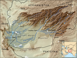
The Sistan Basin is an inland endorheic basin encompassing large parts of southwestern Afghanistan and minor parts of southeastern Iran, one of the driest regions in the world and an area subjected to prolonged droughts. Its watershed is a system of rivers flowing from the highlands of Afghanistan into freshwater lakes and marshes and then to its ultimate destination: Afghanistan's saline Godzareh depression, part of the extensive Sistan terminal basin. The Helmand River drains the basin's largest watershed, fed mainly by snowmelt from the mountains of Hindu Kush, but other rivers contribute also.

<span class="mw-page-title-main">Lake Chad flooded savanna</span> Flooded grassland ecoregion in Africa

The Lake Chad flooded savanna is a flooded grasslands and savannas ecoregion in Africa. It includes the seasonally- and permanently-flooded grasslands and savannas in the basin of Lake Chad in Central Africa, and covers portions of Cameroon, Chad, Niger, and Nigeria.

Banni Grasslands Reserve or Banni grasslands form a belt of arid grassland ecosystem on the outer southern edge of the desert of the marshy salt flats of Rann of Kutch in Kutch District, Gujarat State, India. They are known for rich wildlife and biodiversity and are spread across an area of 3,847 square kilometres. They are currently legally protected under the status as a protected or reserve forest in India. Though declared a protected forest more than half a century ago Gujarat state's forest department has recently proposed a special plan to restore and manage this ecosystem in the most efficient way. Wildlife Institute of India (WII) has identified this grassland reserve as one of the last remaining habitats of the cheetah in India and a possible reintroduction site for the species.

Toolibin Lake is a seasonal fresh to brackish water perched lake or wooded swamp, in south-western Australia. The lake is contained with a 493-hectare (1,218-acre) nature reserve and it is located about 200 kilometres (124 mi) south-east of Perth, in the Shire of Narrogin, and 40 kilometres (25 mi) east of the town of Narrogin, in the Wheatbelt region of Western Australia. The lake is listed by the Australian Government as a threatened ecological community under the Environment Protection and Biodiversity Conservation Act 1999.

<span class="mw-page-title-main">Mulga Lands</span>

The Mulga Lands are an interim Australian bioregion of eastern Australia consisting of dry sandy plains with low mulga woodlands and shrublands that are dominated by Acacia aneura (mulga). The Eastern Australia mulga shrublands ecoregion is coterminous with the Mulga Lands bioregion.

<span class="mw-page-title-main">Astrakhan Nature Reserve</span>

Astrakhan Nature Reserve is a Russian 'zapovednik' covering an area including the islands and wetlands of the Volga Delta, where the Volga River enters the northwest sector of the Caspian Sea. The landscape is one of extensive reeds, cattails and willows and is an important nesting area for waterfowl and wading birds. The areas is rich in fish, with 50 species recorded, including beluga sturgeon. The reserve is situated in the Ikryaninsky District of Astrakhan Oblast. Since 1975, the territory has been part of a Ramsar wetlands site of international importance, and since 1984 it has been included in the World Network of Biosphere Reserves.

<span class="mw-page-title-main">Jiwani Coastal Wetland</span> Wetland located in Balochistan, Pakistan, near the town of Jiwani

The Jiwani Coastal Wetland is a wetland located in Balochistan, Pakistan, near the town of Jiwani. The site is one of the 19 Ramsar sites in Pakistan and was inducted in 2001.

<span class="mw-page-title-main">Rostov Nature Reserve</span>

Rostov Nature Reserve is a Russian 'zapovednik' that protects a variety of sensitive southern European steppe wetlands, the largest herd of wild horses in Europe, and also wetland habitat for birds. The protected areas are divided into five sections that cover the waters of Lake Manych-Gudilo, islands in that lake, surrounding steppe and shore lands. The reserve is situated in the Orlovsky District, of Rostov Oblast, about 100 km northeast of Rostov-on-Don. It is part of a Ramsar Wetland site of international importance.

<span class="mw-page-title-main">Belqeys Castle</span> Archaeological complex in North Khorasan Province, Iran

Belqeys Castle is a castle located in Esfarayen County in North Khorasan Province, Iran. The fortress dates back to the Sasanian Empire.

<span class="mw-page-title-main">Hamoon Jazmourian Basin</span> Drainage basin in Iran

Hamoon Jazmourian Basin is a Endorheic basin of Iran. In the classification of basins in Iran, it is considered a sub-basin and is a subset of the Central Plateau Basin. The area of this basin is 69,390 square kilometers and the rivers and canals of this basin enter Hamoon Jazmourian Lake.

References

  1. "Miqan Wetland". Tehran Times. Retrieved 2022-02-12.
  2. "Miqan wetland fire extinguished after 16 hours". Tehran Times. 2017-12-23. Retrieved 2022-02-12.
  3. 1 2 "Meighan Desert, Markazi (+98 86 1504), Iran". mapsus.net. Retrieved 2022-02-12.
  4. "Miqan wetland". persiantrips.net. Retrieved 2022-02-12.
  5. "علی‌اکبر دهخدا", ویکی‌پدیا، دانشنامهٔ آزاد (in Persian), 2022-02-21, retrieved 2022-03-15
  6. "شهرداری اراک > جذابیت های گردشگری > تالاب میقان اراک". 2019-07-10. Archived from the original on 10 July 2019. Retrieved 2022-03-15.
  7. "Miqan wetland fire extinguished after 16 hours". Tehran Times. 2017-12-23. Retrieved 2022-03-18.
  8. Hajarian, Mohammad Hossein; Atarchi, Sara; Hamzeh, Saeid (2021-11-22). "Monitoring seasonal changes of Meighan wetland using SAR, thermal and optical remote sensing data". Physical Geography Research Quarterly. 53 (3): 365–380. doi:10.22059/jphgr.2021.322649.1007610. ISSN   2008-630X.
  9. "Miqan Wetland; Beautiful and spectacular view of bird habitat". Iran Tours & Travel - Iranviva. 2021-08-01. Retrieved 2022-03-25.
  10. "Meighan Wetland, a desert wetland in Iran - Hipersia". hipersia.com. Retrieved 2022-02-12.
  11. "Miqan wetland". persiantrips.net. Retrieved 2022-03-28.
  12. YJC, خبرگزاری باشگاه خبرنگاران | آخرین اخبار ایران و جهان | (October 19, 2013). "تالاب میقان باید هرچه سریعتر به کنوانسیون رامسر بپیوندد". fa (in Persian). Retrieved 2022-04-09.
  13. "Miqan wetland". persiantrips.net. Retrieved 2022-04-15.