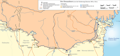
The Moesian Limes (Latin: Limes Moesicus) is the modern term given to a linked series of Romanforts on the northern frontier of the Roman province of Moesia along the Danube between the Black Sea shore and Pannonia (present-day Hungary) and dating from the 1st century AD. It was the eastern section of the so-called Danubian Limes[1] and protected the Roman provinces of Upper and Lower Moesia south of the river. The eastern section (today in Romania) is often called the limes Scythiae minoris[2] as it was located in the late Roman province of Scythia Minor.
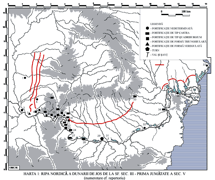
The Moesian Limes[3] includes essentially the linked forts and stations along the Danube from Singidunum (Belgrade) to the mouth of the Danube on the Black Sea.[4] It was not fortified with palisades or a boundary wall but the forts were linked by a road and included eight legionary fortresses, many forts for auxiliary troops and watch/signal towers.[5] Forts along the Danube are 10 to 30 km apart and inter-visibility does not often exist.
The frontier was divided into two major sections by the river Iskar at Oescus which also marked the border between the provinces of Moesia Superior and Inferior.
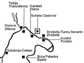
The gorge of the river at Djerdap formed a barrier between north-west and north-east Moesia that was difficult to overcome, initially making communication between the Pannonian and the Moesian armies difficult. This problem was solved only by the construction of a 3m-wide road under Trajan, who had the Legio VII Claudia chisel into the rock walls replacing a wooden towpath construction that was susceptible to damage by drift ice. Other improvements for shipping included the construction of a canal near Novi Sip to avoid the dangerous rapids and shoals there. The two ends of the canal were secured with forts. The best-known building on the Moesian Limes was Trajan's Bridge at Drobeta/ Turnu Severin from the early 2nd century AD, the first permanent bridge connection across the lower Danube which was also guarded on both banks by forts.
Augustus was the first to advance the empire's south-eastern European border from Macedonia to the line of the Danube to increase strategic depth between the border and Italy and also to provide a major river supply route between the Roman armies in the region.[8] The lower Danube was given priority and Marcus Licinius Crassus, proconsul of Macedonia from 29 BC,[9] drove the Bastarnae back toward the Danube. Legion IV Scythica was initially stationed in Moesia (probably at Viminacium) to counter threats from neighbouring Thrace and aggressive peoples north of the Danube. But as a result of the Dacians constant looting that occurred whenever the Danube froze, Augustus decided to send against them some of his proven generals such as Sextus Aelius Catus and Gnaeus Cornelius Lentulus Augur (sometime between 1-11 AD[10]). Lentulus pushed them back across the Danube and placed numerous garrisons on the right bank of the river to defend against possible and future incursions.[11] These became the Moesian Limes. At this stage forts on the frontier consisted of earth walls with wooden palisades.
Moesia became a separate province in 6 AD. Roman military excursions across the Danube continued over 100 km to the north of the Danube delta.[12]
In the winter of 98/99 AD Trajan arrived on the Danube, quartered at the Diana Fort near Kladovo,[citation needed] and started Dacian war preparations on the Iron Gates gorges. He extended the road in the gorge for 30 miles, as he stated on the well-known inscription of 100 AD. In 101 he also cut a canal nearby, as he also recorded on a marble plaque near Diana Fort which reads:
“because of the dangerous cataracts he diverted the river and made the whole Danube navigable”: (ob periculum cataractarum, derivato flumine, tutam Danuvii navigationem facit).
Trajan restored stone defences in the area and rebuilt all earthworks in stone. Just below the Pontes fort a large port and massive horrea were built.[citation needed]
Between the first and second Dacian wars, from 103 to 105, the imperial architect Apollodorus of Damascus constructed Trajan's Bridge, one of the greatest achievements in Roman architecture.
Full military occupation of the plain between the Carpathian foothills and the Danube may already have occurred by the end of Trajan’s First Dacian War (101/102). The majority of forts here, however, were established after the final conquest of the Dacian kingdom in 106 AD. However, the Romans did remove the garrisons of the Danube Limes because of the need to preserve the control of transport and trade on the danube ([15] and because troops there were a kind of strategic reserve for other fronts if needed.
After a long period of peace Septimius Severus reconstructed the Moesia Superior defences and under Caracalla more reconstruction was done as can be seen at Pontes where, as with many other Iron Gates forts, the original layout was supplemented with the gates and towers. A new fort was built on an island at the Porečka river.
Retreat to the Danube
The Roman abandonment of Dacia probably occurred during the reign of Gallienus (260-68), before the traditional date of around 275 when Aurelian established the new province of Dacia south of the Danube.[16]
In the Late Roman period, the extent of control and military occupation over territory north of the Danube remains controversial. One Roman fort (Pietroasa de Jos), well beyond the Danubian Limes and near Moldavia, seems to have been occupied in the 4th century AD, as were bridge-head forts (Sucidava,[17]Barboşi, and the unlocated Constantiniana Daphne) along the left bank of the river.[18]
The "Brazda lui Novac de Nord" (or "Constantine Wall") has been shown by recent excavations to date from emperor Constantine around 330 AD,[19] at the same time as the "Devil's Dykes" (or "Limes Sarmatiae"), a series of defensive earthen ramparts-and-ditches built by the Romans between Romania and the Pannonian plains.[20]
Similarly, although considered 1st century and believed to predate the Limes Transalutanus, the function and origins of a shorter section of bank and ditch known as the "Brazda lui Novac de Sud" remain uncertain. The absence of any evidence for Late Roman forts or settlements along its course and south of it rather suggests a later, probably medieval, date.
↑ R. Ployer, M. Polak, R. Schmidt, The Frontiers of the Roman Empire. A Thematic Study and proposed World Heritage Nomination Strategy, Vienna/Nijmegen/Munich, 2017, p. 41, 75-6
↑ Emil Jęczmienowski, The Fortifications of the Upper Moesian Limes. Topography, Forms, Garrison Sizes, Światowit: annual oF the institute oF archaeology of the university of warsaw, Vol. X (li) (2012)
↑ Jęczmienowski, Emil. “The Fortifications of the Upper Moesian Limes on the Eve of Trajan’s Dacian Wars.” Ad Fines Imperii Romani. Studia Thaddaeo Sarnowski Ab Amicis, Collegis Discipulisque Dedicata, 2015.
↑ Gudea N., Die nordgrenze der römischen provinz obermoesien. Materialien zu ihrer Geschichte (86–275 n. Chr.), “Jahrbuch des Römisch-Germanischen zentralmuseums Mainz” 48, 1–118.
↑ I.B. Cătăniciu, Evolution of the system of defence works in Roman Dacia, BAR International series 116, Oxford, 1981 pp 53-55
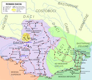
Dacia was the land inhabited by the Dacians, its core in Transylvania, stretching to the Danube in the south, the Black Sea in the east, and the Tisza in the west. The Carpathian Mountains were located in the middle of Dacia. It thus roughly corresponds to present-day Romania, as well as parts of Moldova, Bulgaria, Serbia, Hungary, Slovakia, and Ukraine.
Moesia was an ancient region and later Roman province situated in the Balkans south of the Danube River. Moesian Province was first administered by governor of Noricum as 'Civitates of Moesia and Triballia'. It included most of the territory of modern eastern Serbia, Kosovo, north-eastern Albania, northern parts of North Macedonia, Northern Bulgaria, Romanian Dobruja and small parts of Southern Ukraine.
The so-called Free Dacians is the name given by some modern historians to those Dacians who putatively remained outside, or emigrated from, the Roman Empire after the emperor Trajan's Dacian Wars. Dio Cassius named them Dakoi prosoroi meaning "neighbouring Dacians".
Oescus, Palatiolon or Palatiolum was an important ancient city on the Danube river in Roman Moesia. It later became known as Ulpia Oescus. It lay northwest of the modern Bulgarian city of Pleven, near the village of Gigen.
Domitian's Dacian War was a conflict between the Roman Empire and the Dacian Kingdom, which had invaded the province of Moesia. The war occurred during the reign of the Roman emperor Domitian, in the years 86–88 AD.
Trajan's First Dacian War took place from 101 to 102.
Trajan's Second Dacian War was fought between 105 and 106 because the Dacian king, Decebalus, had broken his peace terms with the Roman Emperor Trajan from the Trajan's First Dacian War.
The military history of Romania deals with conflicts spreading over a period of about 2500 years across the territory of modern Romania, the Balkan Peninsula and Eastern Europe and the role of the Romanian military in conflicts and peacekeeping worldwide.
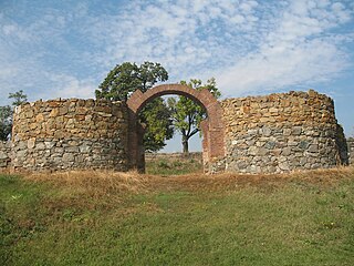
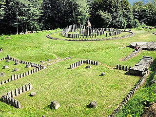
Diana Fort is a Roman fort located near the hamlet of Karataš, 8 km northwest of Kladovo, in eastern Serbia in the Karataš archaeological site. It is located on cliffs of the Đerdap, above the Danube, on a strategic location overlooking the Danube frontier. It has been extensively excavated, is one of the best explored forts of the Moesian Limes, and can be visited today.
Limes Transalutanus is the modern name given to a fortified frontier system of the Roman Empire, built on the western edge of Teleorman's forests as part of the Dacian Limes in the Roman province of Dacia, modern-day Romania.
Capidava was an important Geto-Dacian centre on the right bank of the Danube. After the Roman conquest, it became a civil and military centre, as part of the province of Moesia Inferior and was part of the defensive frontier system of the Limes Moesiae along the Danube.
The Battle of Sarmizegetusa was a siege of Sarmizegetusa, the capital of Dacia, fought in Trajan's Second Dacian War in 106 between the army of the Roman Emperor Trajan, and the Dacians led by King Decebalus.
The castra of Pietroasele was a Roman fort in Roman Dacia located in the centre of Pietroasele (Romania). It was built under Trajan after Trajan's Dacian Wars in about 106 AD but abandoned at the beginning of Hadrian's reign when Wallachia was given up to the Roxolani. It was used again at the beginning of the 3rd century in the reign of Caracalla. It was rebuilt by Constantine the Great after his victory over the Goths in 328 when Constantine created the Constantine Wall of the Dacian Limes. It was abandoned in the same century.
Roman Dacia was a province of the Roman Empire from 106 to 271–275 AD. Its territory consisted of what are now the regions of Oltenia, Transylvania and Banat. During Roman rule, it was organized as an imperial province on the borders of the empire. It is estimated that the population of Roman Dacia ranged from 650,000 to 1,200,000. It was conquered by Trajan (98–117) after two campaigns that devastated the Dacian Kingdom of Decebalus. However, the Romans did not occupy its entirety; Crișana, Maramureș, and most of Moldavia remained under the Free Dacians.
This section of the timeline of Romanian history concerns events from Late Neolithic until Late Antiquity, which took place in or are directly related with the territory of modern Romania.
In Roman Dacia, an estimated 50,000 troops were stationed at its height.
The Danubian Limes, or Danube Limes, refers to the Roman military frontier or limes which lies along the River Danube in the present-day German state of Bavaria, in Austria, Slovakia, Hungary, Croatia, Serbia, Bulgaria and Romania.
The Dacian Limes is the generic modern term given to a collection of ramparts and linked series of Roman forts on the frontiers of the Roman province of Dacia dating from the early 2nd century AD. They ran for about 1,000 km and included the:
The history of Dacia comprises the events surrounding the historical region roughly corresponding to the present territory of Romania and Moldova and inhabited by the Getae and Dacian peoples, with its capital Sarmizegetusa Regia.
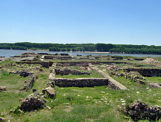
Pontes fort was an ancient Roman fort situated on the river Danube in the Roman province of Moesia and forming a key part of the Limes Moesiae frontier system. It is near the modern town of Kladovo, Serbia. It was built in about 103-105 AD and is one of the most important Roman sites along the Danube as it protected the southern end of the strategic Trajan's Bridge over the river.
This page is based on this Wikipedia article Text is available under the CC BY-SA 4.0 license; additional terms may apply. Images, videos and audio are available under their respective licenses.


