Moore Station, Texas | |
---|---|
Coordinates: 32°11′14″N95°33′47″W / 32.18722°N 95.56306°W | |
Country | United States |
State | Texas |
County | Henderson |
Area | |
• Total | 1.26 sq mi (3.27 km2) |
• Land | 1.26 sq mi (3.27 km2) |
• Water | 0.00 sq mi (0.00 km2) |
Elevation | 420 ft (130 m) |
Population (2020) | |
• Total | 160 |
• Density | 174.33/sq mi (67.32/km2) |
Time zone | UTC-6 (Central (CST)) |
• Summer (DST) | UTC-5 (CDT) |
ZIP code | 75770 |
Area code | 903 |
FIPS code | 48-49272 [3] |
GNIS feature ID | 1341888 [2] |
Moore Station is a city in Henderson County, Texas, United States. The population was 160 at the 2020 census. [4] It was founded in 1876 by Anderson Moore, a former "mulatto" slave. [5] [6]
Moore Station is located in eastern Henderson County at 32°11′14″N95°33′47″W / 32.18722°N 95.56306°W (32.187284, –95.562964), [7] along Farm to Market Road 314. It is 10 miles (16 km) south of Brownsboro and 9 miles (14 km) north of Poynor. Athens, the county seat, is 20 miles (32 km) to the west.
According to the United States Census Bureau, Moore Station has a total area of 1.3 square miles (3.3 km2), all of it land. [4]
Census | Pop. | Note | %± |
---|---|---|---|
1980 | 335 | — | |
1990 | 256 | −23.6% | |
2000 | 184 | −28.1% | |
2010 | 201 | 9.2% | |
2020 | 160 | −20.4% | |
U.S. Decennial Census [8] |
Race | Number | Percentage |
---|---|---|
White (NH) | 11 | 6.88% |
Black or African American (NH) | 142 | 88.75% |
Native American or Alaska Native (NH) | 1 | 0.63% |
Asian (NH) | 1 | 0.63% |
Some Other Race (NH) | 1 | 0.63% |
Mixed/Multi-Racial (NH) | 3 | 1.88% |
Hispanic or Latino | 1 | 0.63% |
Total | 160 |
As of the 2020 United States census, there were 160 people, 64 households, and 37 families residing in the city.
As of the census [3] of 2000, there were 184 people, 69 households, and 52 families residing in the city. The population density was 142.1 inhabitants per square mile (54.9/km2). There were 78 housing units at an average density of 60.2 per square mile (23.2/km2). The racial makeup of the city was 1.09% White and 98.91% African American.
There were 69 households, out of which 42.0% had children under the age of 18 living with them, 43.5% were married couples living together, 24.6% had a female householder with no husband present, and 24.6% were non-families. 24.6% of all households were made up of individuals, and 11.6% had someone living alone who was 65 years of age or older. The average household size was 2.67 and the average family size was 3.13.
In the city, the population was spread out, with 27.7% under the age of 18, 7.6% from 18 to 24, 23.4% from 25 to 44, 23.9% from 45 to 64, and 17.4% who were 65 years of age or older. The median age was 41 years. For every 100 females, there were 84.0 males. For every 100 females age 18 and over, there were 87.3 males.
The median income for a household in the city was $28,393, and the median income for a family was $26,875. Males had a median income of $18,125 versus $17,143 for females. The per capita income for the city was $9,378. About 16.9% of families and 18.1% of the population were below the poverty line, including 22.2% of those under the age of eighteen and 20.0% of those 65 or over.
Moore Station is served by the Brownsboro Independent School District.
Anderson and Lucinda Moore, for whom the town is believed to have been named, were a pioneer family in the area; according to one source, they were former slaves. In 1876 they donated a plot of land for a Methodist church and for a school. The church and school made up the original Moore Station. [12] Many freed slaves moved to the area from nearby Fincastle after slavery to purchase land and enjoy their newfound freedom. From the 1870 census the following were residents of the area:
After emancipation freedman began to sharecrop with their former masters in communities like Fincastle, Pleasant Ridge and New York. Around 1872 they soon began to leave behind former plantations like Crossroads, Flat Creek, Stockard and such, and former masters such as Ratliff, Faulk, Wofford and Coleman. They began to purchase land in the Moore Station area, including the Andersons, Cofers, Douglases and Hightowers.
These slaves were brought into Texas from South Carolina, Alabama and Georgia by the pioneer families. These pioneer families were descendants of Huguenots who were escaping religious persecution in Europe. Some were descendants of the founding fathers, families like John O. Bullard, William Weatherford, Lachlan Durant, the Faulk brothers and others who migrated into the Deep South, which was Native American in the 1700s, to uproot tribes like the Creek and Seminole people.
In order to get a foothold into the deep South, some married into the tribes and began to raise families. They established outposts like Fort Mims and Little Tallassee in Alabama. This action later led to the infamous Trail of Tears. Most of the population of present-day Moore Station are descendants of their slaves such as Lousia Durant, Addison/Adderson Cofer and Ralph Calhoun.
Botetourt County is a US county that lies in the Roanoke Region of the Commonwealth of Virginia. Located in the mountainous portion of the state, the county is bordered by two major ranges, the Blue Ridge Mountains and the Appalachian Mountains.
Calhoun County is a county located in the U.S. state of Texas. As of the 2020 census, the population was 20,106. Its county seat is Port Lavaca. The county is named for John Caldwell Calhoun, the seventh vice president of the United States. Calhoun County comprises the Port Lavaca, TX Micropolitan Statistical Area, which is also included in the Victoria-Port Lavaca, TX Combined Statistical Area.
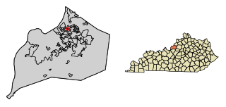
Jefferson County is located in the north central portion of the U.S. state of Kentucky. As of the 2020 census, the population was 782,969. It is the most populous county in the commonwealth.
Bellewood is a home rule-class city in Jefferson County, Kentucky, United States. The city was formally incorporated by the state assembly in 1950. The population was 321 at the 2010 census.
Brownsboro Farm is a home rule-class city in Jefferson County, Kentucky, United States. The population was 648 at the 2010 census.
Brownsboro Village is a home rule-class city in Jefferson County, Kentucky, United States. The population was 319 at the 2010 census.
Crossgate is a home rule-class city in Jefferson County, Kentucky, United States. The population was 225 at the 2010 census.
Druid Hills is a home rule-class city in Jefferson County, Kentucky, United States. The population was 308 at the 2010 census. It was incorporated in 1950.
Fincastle is a home rule-class city in eastern Jefferson County, Kentucky, United States. The population was 817 at the 2010 census.
Old Brownsboro Place is a home rule-class city in Jefferson County, Kentucky, United States, and a part of the united Metro government. The population was 353 at the 2010 census.
Spring Valley is a home rule-class city in Jefferson County, Kentucky, United States. Spring Valley Estates, begun in 1964, remained an unincorporated area until September, 1983. At that time, the City of Spring Valley was established to provide services. The current mayor is Gerri Willis. The population was 654 at the 2010 census. Population has increased to 837 based on the 2020 census.
Thornhill is a home rule-class city in Jefferson County, Kentucky, United States. The population was 178 at the 2010 census.
Calhoun is a home rule-class city in McLean County, Kentucky, United States. The population was 725 at the 2020 census. It is the county seat of McLean County. It is included in the Owensboro, Kentucky Metropolitan Statistical Area.
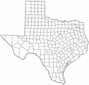
Point Comfort is a city in Calhoun County, Texas, United States. It is a part of the Victoria, Texas Metropolitan Statistical Area. The population was 737 at the 2010 census.
Port Lavaca is a city in Calhoun County, located in the U.S. state of Texas. The population was 12,248 at the 2010 census and 11,557 at the 2020 census. It is the county seat of Calhoun County and part of the Port Lavaca, Texas micropolitan statistical area. Port Lavaca is 130 miles (210 km) southwest of Houston.
Seadrift is a city in Calhoun County, Texas, United States. The population was 1,364 at the 2010 census. It is a part of the Victoria, Texas Metropolitan Statistical Area.
Athens is a city and the county seat of Henderson County, Texas, in the United States. As of the 2020 census, the city population was 12,857. The city has called itself the "Black-Eyed Pea Capital of the World." Athens was selected as one of the first "Certified Retirement Communities" in Texas. It was named after Athens, the capital of Greece.
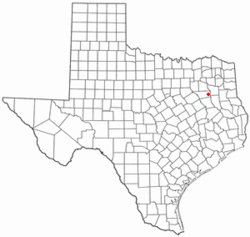
Brownsboro is a city in Henderson County, Texas, United States. The population was 1,212 at the 2020 census, up from 1,039 at the 2010 census. The city is on Texas State Highway 31.
Coffee City is a small city in southeast Henderson County, Texas, United States. The population was 278 at the 2010 census, up from 193 at the 2000 census.
Fincastle is a town in Botetourt County, Virginia, United States. The population was 755 at the 2020 census. It is the county seat of Botetourt County.