
Cape Guardafui is a headland in the autonomous Puntland region in Somalia. Coextensive with Puntland's Gardafuul administrative province, it forms the geographical apex of the Horn of Africa. Its shore at 51°27'52"E is the second easternmost point on mainland Africa after Ras Hafun. The offshore oceanic strait Guardafui Channel is named after it.

A screw-pile lighthouse is a lighthouse which stands on piles that are screwed into sandy or muddy sea or river bottoms. The first screw-pile lighthouse to begin construction was built by the blind Irish engineer Alexander Mitchell. Construction began in 1838 at the mouth of the Thames and was known as the Maplin Sands lighthouse, and first lit in 1841. However, though its construction began later, the Wyre Light in Fleetwood, Lancashire, was the first to be lit.

Cape Agulhas is a rocky headland in Western Cape, South Africa. It is the geographic southern tip of Africa and the beginning of the traditional dividing line between the Atlantic and Indian Oceans according to the International Hydrographic Organization. It is approximately half a degree of latitude, or 55 kilometres (34 mi), further south than the Cape of Good Hope.

Mossel Bay is a harbour town of about 120,000 people on the Southern Cape of South Africa. It is an important tourism and farming region of the Western Cape Province. Mossel Bay lies 400 kilometres east of the country's seat of parliament, Cape Town, and 400 km west of Port Elizabeth, the largest city in the Eastern Cape. The older parts of the town occupy the north-facing side of the Cape St Blaize Peninsula, whilst the newer suburbs straddle the Peninsula and have spread eastwards along the sandy shore of the Bay.

Cape Henlopen is the southern cape of the Delaware Bay along the Atlantic coast of the United States. It lies in the state of Delaware, near the town of Lewes, where the Delaware Bay meets the Atlantic Ocean. Off the coast on the bay side are two lighthouses, called the Harbor of Refuge Light and the Delaware Breakwater East End Light.

Cape Point is a promontory at the southeast corner of the Cape Peninsula, a mountainous and scenic landform that runs north-south for about thirty kilometres at the extreme southwestern tip of the African continent in South Africa. Table Mountain and the city of Cape Town are close to the northern extremity of the same peninsula. The cape is located at 34°21′26″S18°29′51″E, about 2.3 kilometres (1.4 mi) east and a little north of the Cape of Good Hope on the southwest corner. Although these two rocky capes are very well known, neither cape is actually the southernmost point of the mainland of Africa; that is Cape Agulhas, approximately 150 kilometres (93 mi) to the east-southeast.

The Cape May Lighthouse is a lighthouse located in the U.S. state of New Jersey at the tip of Cape May, in Lower Township's Cape May Point State Park. It was built in 1859 under the supervision of U.S. Army engineer William F. Raynolds, was automated in 1946, and continues operation to this day.
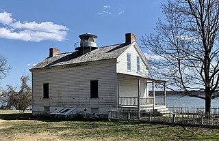
The Jones Point Light is a small river lighthouse located on the Potomac River in Alexandria, Virginia. It was built in 1855.

Cape Spear is a headland located on the Avalon Peninsula of Newfoundland near St. John's in the Canadian province of Newfoundland and Labrador. At a longitude of 52°37' W, it is the easternmost point in Canada and North America, excluding Greenland.

Sea Point is an affluent and densely populated suburb of Cape Town, situated between Signal Hill and the Atlantic Ocean, a few kilometres to the west of Cape Town's Central Business District (CBD). Moving from Sea Point to the CBD, one passes first through the small suburb of Three Anchor Bay, then Green Point. Seaward from Green Point is the area known as Mouille Point, where the local lighthouse is situated. It borders to the southwest the suburb of Bantry Bay. It is known for its large Jewish population, synagogues, and kosher food options.

Bill Baggs Cape Florida State Recreation Area occupies approximately the southern third of the island of Key Biscayne, at coordinates 25°40′25″N80°09′34″W. This park includes the Cape Florida Light, the oldest standing structure in Greater Miami. In 2005, it was ranked as having the 8th best beach in the country, and in 2013 Forbes ranked it at 7th.

Ilhéu de Sal Rei is an uninhabited islet near the coast of Boa Vista Island, Cape Verde. It is located 1 km southwest of the island capital Sal Rei. Its area is 89 ha (0.34 sq mi) and its highest point is 27 m (88.6 ft).

Långe Erik, official name Ölands norra udde, is a Swedish lighthouse built in 1845 and located on a little island, Stora Grundet, in Grankullaviken bay at the north point of Öland, the second largest island in Sweden. The island is connected to Öland by a small bridge built in 1965.

Mouille Point ("Mu-lee") is an affluent suburb of Cape Town, situated between the Victoria and Alfred Waterfront and Granger Bay to the east, Green Point to the south and the Atlantic Ocean to the north and west. The suburb hugs the coastline and is dominated by high-end apartment blocks.
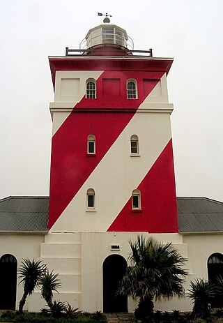
The Green Point Lighthouse, Cape Town is an operational lighthouse on the South African coast. First lit on 12 April 1824, it is located on Mouille Point. The lighthouse was the first solid lighthouse structure on the South African coast and the oldest operational lighthouse in South Africa. The lighthouse was commissioned by acting Governor of the Cape Colony Sir Rufane Shaw Donkin and designed by German architect Herman Shutte. Building commenced in 1821 and was completed in 1823. The lighthouse started operating in 1824. The lighthouse cost approximately £6,420 pounds sterling to build. When the lighthouse was first lit, it burned Argand lamps fueled by sperm whale oil. The light from these lanterns could be seen for 6 nautical miles. The lighthouse was expanded to its present height in 1865. In 1922, the range of the light house was extended to 22 nautical miles when 3rd order dioptric flashing lights were installed. Its present characteristic is a white light flashing every 10 seconds. In 1926, a foghorn was installed in the lighthouse despite a letter of complaint sent to the Mayor of Cape Town in 1923 by Green Point residents. Local Residents call the Green Point Lighthouse "Moaning Minnie".

The Cape North Lighthouse is a cylindrical lighthouse tower with a red and white checkerboard pattern that stood at Money Point, near Cape North, Cape Breton from 1908 to 1980. While originally installed at Cape Race, Newfoundland, this tower is most commonly referred to as the Cape North Lighthouse. It now stands landlocked at the Canada Science and Technology Museum in Ottawa, Ontario, Canada.

Green Point Common, is a park in Green Point, Cape Town, in South Africa, where numerous playing fields and a golf course are situated. The Green Point Urban Park & Biodiversity Garden is just behind Mouille Point and has an entrance on Bay Road.
