
Mount Tom is a remote 7,076-foot (2,157-metre) mountain summit located within Olympic National Park in Jefferson County of Washington state. Its nearest higher neighbor is Mount Olympus, 1.76 mi (2.83 km) to the east. Due to heavy winter snowfalls, Mount Tom supports the massive White Glacier on its northeast slope, despite its modest elevation. This glacier is the westernmost glacier in the contiguous states, and the summit is the westernmost peak higher than 7000+ feet elevation. Precipitation runoff from the mountain drains into tributaries of the Hoh River.
Sentinel Peak is a 6,592-foot-high (2,009 m) mountain summit located in the Olympic Mountains, in Jefferson County of Washington state. Rising in the center of Olympic National Park, its nearest higher neighbor is Mount Fromme, 1.42 miles (2.29 km) to the northwest. Sentinels Sister is a lower 6,301-foot-high (1,921 m) companion summit situated 0.65 miles (1.05 km) to the southwest. The two peaks stand as sentinels above the Dosewalips Valley and Hayden Pass, and were possibly named by an early expedition of the Seattle Mountaineers. Precipitation runoff from the peak drains to Hood Canal via the Dosewallips River.

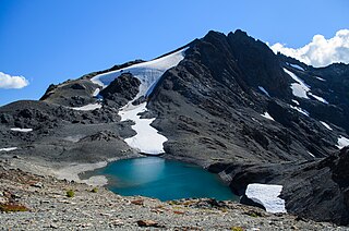
Stephen Peak is a 6,418-foot (1,956-metre) mountain summit located within Olympic National Park in Jefferson County of Washington state. Stephen Peak is the fifth-highest peak in the Bailey Range, which is a subrange of the Olympic Mountains. In clear weather, the mountain can be seen from the visitor center at Hurricane Ridge, appearing to the left of Mount Olympus. Mount Ferry is set 2.26 mi (3.64 km) to the southeast, and Stephen's nearest higher neighbor is Ruth Peak which is an outlier of Mount Carrie, 2.1 mi (3.4 km) to the northwest. Precipitation runoff from the mountain drains into tributaries of the Elwha River and Hoh River. The first ascent of this peak was made in 1961 by Kent Heathershaw, Doug Waali, and Robert Wood.
Mount Pulitzer, also known as Snagtooth, is a 6,283-foot (1,915-metre) mountain summit located within Olympic National Park in Jefferson County of Washington state. Mount Pulitzer is the sixth-highest peak in the Bailey Range, which is a subrange of the Olympic Mountains. Its nearest neighbor is Mount Ferry, 0.58 mi (0.93 km) to the northeast, and its nearest higher neighbor is Stephen Peak, 2.58 mi (4.15 km) to the north. Mount Olympus is set 6.8 mi (10.9 km) to the southwest. In clear weather, the mountain can be seen from the visitor center at Hurricane Ridge. Precipitation runoff from the mountain drains into tributaries of the Elwha and Hoh Rivers.

Aries is a 6,533-foot (1,991-metre) mountain summit located within Olympic National Park in Jefferson County of Washington state. Its neighbors include Mount Olympus, 2.46 mi (3.96 km) to the west, Athena 1.7 mi (2.7 km) to the southwest, and Mount Mathias 1.11 mi (1.79 km) to the northwest. Aries is wedged between the Hoh Glacier and the Humes Glacier, and immediately northeast of Blizzard Pass. Precipitation runoff from the mountain drains into headwaters of the Queets and Hoh Rivers. This mountain was named by glaciologists Richard Hubley and Edward LaChapelle in 1955, in preparation for the International Geophysical Year. It is named for Aries in keeping with the Greek and Roman mythology naming theme surrounding Mount Olympus.
Muncaster Mountain is a 5,910-foot (1,800-metre) mountain summit located within Olympic National Park in Jefferson County of Washington state. It is situated 4.4 mi (7.1 km) south-southeast of Mount Christie, and 14.6 mi (23.5 km) southeast of Mount Olympus. Precipitation runoff from the mountain drains into Rustler Creek, which is a tributary of the Quinault River. Although modest in elevation, relief is significant as the summit rises 4,000 feet above the Rustler Creek valley in one mile.

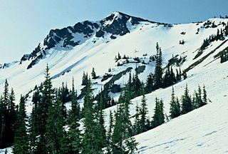
Mount Claywood is a 6,836-foot (2,084-metre) mountain summit located within Olympic National Park in Jefferson County of Washington state. It is situated at the head of Lost River, and 15 mi (24 km) east of Mount Olympus. Its nearest higher neighbor is Mount Cameron, 2.4 mi (3.9 km) to the northeast. Other nearby peaks include Mt. Fromme, 0.58 mi (0.93 km) to the southeast, and Sentinel Peak, 2 mi (3.2 km) also to the southeast. Precipitation runoff from the mountain drains north and west into tributaries of the Elwha River, and east into Claywood Lake, thence Dosewallips River.

Woden is a 6,038-foot (1,840-metre) mountain summit located within Olympic National Park in Jefferson County of Washington state. Its nearest higher neighbor is Mount Tom, 3 mi (4.8 km) to the north-northwest, and Mount Olympus rises 3.8 mi (6.1 km) to the north-northeast. Woden is the highest point in The Valhallas, a sub-range south of Mount Olympus. Precipitation runoff from the mountain drains into tributaries of the South Fork Hoh River and Queets River. The Geri-Freki Glacier, which descends north from Woden. is the only glacier in The Valhallas.

Athena is a 7,365-foot-elevation (2,245 meter) mountain summit located within Olympic National Park in Jefferson County of Washington state. Athena is situated at the head of the Hoh Glacier, and the Hubert Glacier lies below the west aspect. Its neighbors include Mount Olympus, 1.7 mi (2.7 km) to the northwest, and Aries 1.7 mi (2.7 km) to the northeast. Athena has subpeaks "Athena II" (7,259 ft), and "Athena's Owl" (7,000 ft). Precipitation runoff from the mountain drains into the Queets and Hoh Rivers, with Athena being the highest point within the Queets drainage basin.

Crystal Peak is a 6,896-foot-elevation (2,102 meter) mountain summit located within Olympic National Park in Jefferson County of Washington state. Crystal Peak is situated two miles north of Enchanted Valley, near the heads of Hayes River and Quinault River. Topographic relief is significant as the northeast aspect rises 3,300 feet (1,006 meters) above Hayes River in less than one mile. Precipitation runoff from the mountain drains north to the Elwha River via Hayes River and Godkin Creek. Neighbors include line parent Chimney Peak, 2.2 mi (3.5 km) to the south, and proximate parent West Peak, 2.0 mi (3.2 km) to the east. The lower slopes of the mountain are surrounded by Western Red Cedar, Sitka Spruce, Western Hemlock, Alaskan Cedar, Mountain Hemlock, and Douglas-fir of the Quinault Rainforest.

Mount Noyes is a 6,173-foot (1,882-metre) mountain summit located deep within Olympic National Park in Jefferson County of Washington state. Part of the Olympic Mountains, Mount Noyes is situated seven miles southeast of Mount Olympus, and set within the Daniel J. Evans Wilderness. The nearest higher neighbor is Mount Meany, 0.6 mile to the north, and Mount Seattle rises one mile to the southeast. Noyes is a major triple divide point with precipitation runoff from the mountain draining east into the headwaters of the Elwha River, west into headwaters of Saghalie Creek which is a tributary of the Queets River, and south into headwaters of Seattle Creek which is a tributary of the Quinault River. Topographic relief is significant as the east, west, and south aspects of the peak each rise 2,200 feet (670 m) in approximately one mile.

Mount Seattle is a 6,246-foot (1,904-metre) mountain summit located deep within Olympic National Park in Jefferson County of Washington state. Part of the Olympic Mountains, Mount Seattle is situated 7.5 miles southeast of Mount Olympus, and set within the Quinault Rainforest and Daniel J. Evans Wilderness. The nearest higher neighbor is Mount Meany, 1.65 mile to the north-northwest, and Mount Noyes rises one mile to the northwest. Precipitation runoff from the mountain drains north into headwaters of the Elwha River, and south into tributaries of the Quinault River. Topographic relief is significant as the northeast aspect of the peak rises over 3,800 feet (1,160 m) above the Elwha valley in approximately 1.5 mile. Low Divide forms the saddle between Mt. Seattle and Mount Christie.

Mount Wilder is a 5,939-foot (1,810-metre) mountain summit located near the head of the Elwha Valley, deep within Olympic National Park in Jefferson County of Washington state. Part of the Olympic Mountains, Wilder represents the southernmost peak of the Bailey Range. It is situated 8.7 miles east-southeast of Mount Olympus, and is set within the Daniel J. Evans Wilderness. Neighbors include line parent Mount Dana, 2.3 miles (3.7 km) to the northeast, and Mount Seattle rises 3.7 miles to the southwest. The headwaters of the Goldie River form on the south slope of the mountain, and precipitation runoff from the mountain drains into Goldie River and other tributaries of the Elwha River. Topographic relief is significant as the south aspect of the peak rises nearly 3,800 feet (1,160 m) in less than two miles.

The Bailey Range is a mountain range located within Olympic National Park in Washington state.

Ludden Peak is a 5,854-foot (1,784-metre) mountain summit located within Olympic National Park in Jefferson County of Washington state. Ludden Peak is part of the Bailey Range, which is a subrange of the Olympic Mountains, and is set within the Daniel J. Evans Wilderness. In clear weather, the mountain can be seen from the park's visitor center on Hurricane Ridge. The nearest higher neighbor is Mount Scott, one mile to the south-southeast, line parent Mount Ferry rises 1.6 mi (2.6 km) to the southwest, Dodger Point is 1.9 mi (3.1 km) to the northeast, and Stephen Peak is set 2.7 mi (4.3 km) to the northwest. Precipitation runoff from the mountain drains into tributaries of the Elwha River.

Cat Peak is a 5,940-foot (1,810-metre) mountain summit located within Olympic National Park in Clallam County of Washington state.
Mount Scott is a 5,913-foot (1,802-metre) mountain summit located within Olympic National Park in Jefferson County of Washington state.

Mount Barnes is a 5,987-foot (1,825-metre) mountain summit located within Olympic National Park in Jefferson County of Washington state. Mount Barnes is part of the Bailey Range, which is a subrange of the Olympic Mountains, and is set within the Daniel J. Evans Wilderness. Neighbors include Mount Queets, 1.7 mi (2.7 km) to the southwest, and Mount Olympus is set 6.2 mi (10.0 km) to the west. Precipitation runoff from the mountain drains west into the Queets River, south into headwaters of the Elwha River, and northeast into Goldie River which is a tributary of the Elwha. Topographic relief is significant as the summit rises 3,200 feet (975 m) above Elwha Basin in approximately two miles.

Mount Childs is a 6,193-foot (1,888-metre) mountain summit located within Olympic National Park in Jefferson County of Washington state. Mount Childs is part of the Bailey Range, which is a subrange of the Olympic Mountains, and is set within the Daniel J. Evans Wilderness. Neighbors include line parent Mount Pulitzer, 1.7 mi (2.7 km) to the north, Mount Barnes, 2 mi (3.2 km) to the south, and Mount Olympus is situated 5.6 mi (9.0 km) to the west. Precipitation runoff from the mountain drains west into headwaters of the Hoh River, and east into Goldie River, which is a tributary of the Elwha River.
Lost Peak is a 6,515-foot-elevation (1,986 meter) mountain summit located within Olympic National Park in Jefferson County of Washington state. Part of the Olympic Mountains, Lost Peak is situated immediately northeast of Lost Pass, and is set within the Daniel J. Evans Wilderness. Precipitation runoff from the mountain drains east into the Dosewallips River, and west into headwaters of the Lost River. Neighbors include line parent Mount Cameron, 0.8 mi (1.3 km) to the north, along with Mount Fromme and Mount Claywood, both 1.8 mi (2.9 km) to the southwest. Topographic relief is significant as the southeast aspect rises 2,500 feet (762 meters) above the Dosewallips River in approximately one mile. This landform's name has been officially adopted by the U.S. Board on Geographic Names. The origin of the "Lost" name is unknown, but a park ranger once described the river area as a "good place to get lost" because of the confusing and difficult travel.


