
Mount Deception is a peak in the Olympic Mountains of Cascadia. It is in Olympic National Park on the Olympic Peninsula in the U.S. state of Washington.

Mount Mystery is a prominent 7,639-foot (2,328-metre) mountain summit located in the Olympic Mountains in Jefferson County of Washington state. It is located within Olympic National Park on the Olympic Peninsula. Mount Mystery is the sixth-highest peak of the Olympic Mountains, after Mount Olympus, Mount Deception, Mount Constance, Mount Johnson, and Inner Constance. Its nearest higher neighbor is Mount Deception, 1.32 mi (2.12 km) to the north-northwest. Little Mystery (6941 ft) is a subsidiary summit south of Mount Mystery.

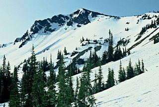
Warrior Peak is a 7,320+ ft double summit mountain located in Olympic National Park in Jefferson County of Washington state. Warrior is the 11th highest peak in the Olympic Mountains Range. The southeast summit is the slightly higher of the two summits, the northwest peak is estimated at 7285 feet elevation. Warrior Peak is easy to identify from Seattle, since it appears as the first prominent peak immediately north of Mount Constance, which is the dominant peak on the skyline. Warrior's nearest higher peak is in fact Mount Constance, 0.8 mi (1.3 km) to the south-southeast. The first ascent of the mountain was made in 1945 by Fred Beckey, who solo climbed both summits, and named the mountain.

Mount Tom is a remote 7,076-foot (2,157-metre) mountain summit located within Olympic National Park in Jefferson County of Washington state. Its nearest higher neighbor is Mount Olympus, 1.76 mi (2.83 km) to the east. Due to heavy winter snowfalls, Mount Tom supports the massive White Glacier on its northeast slope, despite its modest elevation. This glacier is the westernmost glacier in the contiguous states, and the summit is the westernmost peak higher than 7000+ feet elevation. Precipitation runoff from the mountain drains into tributaries of the Hoh River.

White Mountain is a 6,378-foot (1,944-metre) mountain summit located in the Olympic Mountains, in Jefferson County of Washington state. Situated in Olympic National Park, its nearest higher peak is Mount La Crosse, 0.95 mi (1.53 km) to the northeast, and an unnamed glacier lies in the north cirque between the two peaks. The Anderson massif lies 3.1 mi (5.0 km) to the north of White Mountain. Precipitation runoff from the mountain drains into tributaries of the Quinault River and Duckabush River.
Sentinel Peak is a 6,592-foot-high (2,009 m) mountain summit located in the Olympic Mountains, in Jefferson County of Washington state. Rising in the center of Olympic National Park, its nearest higher neighbor is Mount Fromme, 1.42 miles (2.29 km) to the northwest. Sentinels Sister is a lower 6,301-foot-high (1,921 m) companion summit situated 0.65 miles (1.05 km) to the southwest. The two peaks stand as sentinels above the Dosewalips Valley and Hayden Pass, and were possibly named by an early expedition of the Seattle Mountaineers. Precipitation runoff from the peak drains to Hood Canal via the Dosewallips River.

Mount Henderson is a 6,003 ft mountain summit located in the Olympic Mountains, in Mason County of Washington state. It is situated on the shared boundary of Olympic National Park with Mount Skokomish Wilderness. Its nearest higher peak is Mount Skokomish, 0.91 mi (1.46 km) to the east-northeast. Precipitation runoff from the mountain drains into the Hamma Hamma River and Skokomish River. The mountain's name honors Louis Forniquet Henderson (1853-1942), a pioneering botanist and mountaineer who accompanied Lieutenant O'Neil on his 1890 expedition into the Olympic Mountains.

Mount Cruiser is a 6,104 ft mountain summit located in the Olympic Mountains, in Mason County of Washington state. It is situated in Mount Skokomish Wilderness on land managed by Olympic National Forest. Cruiser is the highest point on Sawtooth Ridge, and its nearest higher peak is Mount Skokomish, 2.1 mi (3.4 km) to the north-northeast. Cruiser has two sub-peaks, Alpha, and Beta, the latter of which lies on the Olympic National Park boundary. The first ascent of the peak was made in 1937 by Paul Crews and Ray Layton. The mountain was named by the first ascent party to recognize their club, the Bremerton Ski Cruisers. The mountain's name was officially adopted in 1961 by the United States Board on Geographic Names. Precipitation runoff from the mountain drains into the Hamma Hamma River.

Stephen Peak is a 6,418-foot (1,956-metre) mountain summit located within Olympic National Park in Jefferson County of Washington state. Stephen Peak is the fifth-highest peak in the Bailey Range, which is a subrange of the Olympic Mountains. In clear weather, the mountain can be seen from the visitor center at Hurricane Ridge, appearing to the left of Mount Olympus. Mount Ferry is set 2.26 mi (3.64 km) to the southeast, and Stephen's nearest higher neighbor is Ruth Peak which is an outlier of Mount Carrie, 2.1 mi (3.4 km) to the northwest. Precipitation runoff from the mountain drains into tributaries of the Elwha River and Hoh River. The first ascent of this peak was made in 1961 by Kent Heathershaw, Doug Waali, and Robert Wood.

Mount Fitzhenry is a 6,050-foot (1,840-metre) mountain summit located within Olympic National Park in Clallam County of Washington state. Mt. Fitzhenry is in the Bailey Range which is a subrange of the Olympic Mountains. In clear weather, the mountain can be seen from the visitor center at Hurricane Ridge. Its nearest higher neighbor is Mount Fairchild, 1.57 mi (2.53 km) to the south. Precipitation runoff from the mountain drains into tributaries of the Elwha River. Mount Fitzhenry is situated at the head of Fitzhenry Creek, and both are named for Edward Allen Fitzhenry (1868–1937), Clallam County surveyor from 1892-1900. President Woodrow Wilson appointed Fitzhenry as Washington Surveyor General in 1913, and he later served as Deputy State Land Commissioner.
Mount Fairchild, also known as Mount William Fairchild, is a 6,900-foot (2,100-metre) glaciated mountain summit located within Olympic National Park in Clallam County of Washington state. Mt. Fairchild is the second-highest peak in the Bailey Range which is a subrange of the Olympic Mountains. Its nearest higher neighbor is Mount Carrie, 0.84 mi (1.35 km) to the southwest, and Ruth Peak is set 0.92 mi (1.48 km) to the south. In clear weather, the mountain can be seen from the visitor center at Hurricane Ridge. Precipitation runoff from the mountain drains into tributaries of the Elwha River.

Mount Ferry is a 6,195-foot (1,888-metre) mountain summit located within Olympic National Park in Jefferson County of Washington state. Mount Ferry is the eighth-highest peak in the Bailey Range, which is a subrange of the Olympic Mountains. In clear weather, the mountain can be seen from the visitor center at Hurricane Ridge. Its nearest higher neighbor is Mount Pulitzer, 0.6 mi (0.97 km) to the southwest. Stephen Peak is set 2.26 mi (3.64 km) to the northwest, and Mount Olympus is 7.2 mi (11.6 km) to the southwest. Precipitation runoff from the mountain drains into tributaries of the Elwha and Hoh Rivers.

Ruth Peak is a 6,850+ ft glaciated mountain summit located within Olympic National Park in Clallam County of Washington state. Ruth Peak is the third-highest peak in the Bailey Range, which is a subrange of the Olympic Mountains. Its nearest higher neighbor is Mount Carrie, 0.91 mi (1.46 km) to the northwest, and Mount Fairchild is set 0.92 mi (1.48 km) to the north. In clear weather, the mountain can be seen from the visitor center at Hurricane Ridge. Precipitation runoff from the mountain drains into tributaries of the Hoh and Elwha Rivers. The first ascent of this peak was made in 1961 by Bert Brown, Roy Etten, and Victor Nelson.

Martin Peak is a mountain summit in the Olympic Mountains and is located in Jefferson County of Washington state. It is located within Olympic National Park. At 7,638 feet (2,328 m) high, Martin Peak is the seventh-highest peak of the Olympic Mountains, and the second-highest peak in The Needles range, which is a subset of the Olympic range. Its nearest higher neighbor is Mount Johnson, 0.53 mi (0.85 km) to the north-northwest. Precipitation runoff from this peak drains west into headwaters of Gray Wolf River, or east into Royal Creek, both of which are part of the Dungeness River drainage basin. Martin Peak was given its name based on the first ascent in 1940 by George W. Martin (1901–1970), and Elvin Johnson.

Sundial is a 7,200+ ft mountain summit located within Olympic National Park, in Jefferson County of Washington state. Sundial is part of The Needles range, which is a subrange of the Olympic Mountains. Its nearest higher neighbor is Mount Clark, 0.27 mi (0.43 km) to the northwest, and Mount Johnson is set 0.45 mi (0.72 km) to the west. The climbing routes on Sundial start at class 3 scrambling via the East Face, and range up to class 5 via the South Side Face. The first ascent of the mountain was made in 1944 by Adel and William Degenhardt. The mountain is so named because the time of day can be approximated as an observer in Royal Basin watches the sun's rays make their way down the east face of this mountain in the morning. Precipitation runoff from the mountain drains into Royal Creek which is a tributary of the Dungeness River.

Mount Mathias is a 7,156-foot (2,181-metre) mountain summit located within Olympic National Park in Jefferson County of Washington state. Its nearest higher neighbor is Mount Olympus, 1.76 mi (2.83 km) to the east. Mount Mathias is wedged between the massive Blue Glacier below its west slope, and the Hoh Glacier on the east side. Precipitation runoff from the mountain drains into the Hoh River.

Aries is a 6,533-foot (1,991-metre) mountain summit located within Olympic National Park in Jefferson County of Washington state. Its neighbors include Mount Olympus, 2.46 mi (3.96 km) to the west, and Mount Mathias 1.11 mi (1.79 km) to the northwest. Aries is wedged between the Hoh Glacier and the Humes Glacier, and immediately northeast of Blizzard Pass. Precipitation runoff from the mountain drains into headwaters of the Queets and Hoh Rivers. This mountain was named by glaciologists Richard Hubley and Edward LaChapelle in 1955, in preparation for the International Geophysical Year. It is named for Aries in keeping with the Greek and Roman mythology naming theme surrounding Mount Olympus.
Muncaster Mountain is a 5,910-foot (1,800-metre) mountain summit located within Olympic National Park in Jefferson County of Washington state. It is situated 4.4 mi (7.1 km) south-southeast of Mount Christie, and 14.6 mi (23.5 km) southeast of Mount Olympus. Precipitation runoff from the mountain drains into Rustler Creek, which is a tributary of the Quinault River. Although modest in elevation, relief is significant as the summit rises 4,000 feet above the Rustler Creek valley in one mile.

Mount Claywood is a 6,836-foot (2,084-metre) mountain summit located within Olympic National Park in Jefferson County of Washington state. It is situated at the head of Lost River, and 15 mi (24 km) east of Mount Olympus. Its nearest higher neighbor is Mount Cameron, 2.4 mi (3.9 km) to the northeast. Other nearby peaks include Mt. Fromme, 0.58 mi (0.93 km) to the southeast, and Sentinel Peak, 2 mi (3.2 km) also to the southeast. Precipitation runoff from the mountain drains north and west into tributaries of the Elwha River, and east into Claywood Lake, thence Dosewallips River.

Woden is a 6,038-foot (1,840-metre) mountain summit located within Olympic National Park in Jefferson County of Washington state. Its nearest higher neighbor is Mount Tom, 3 mi (4.8 km) to the north-northwest, and Mount Olympus rises 3.8 mi (6.1 km) to the north-northeast. Woden is the highest point in The Valhallas, a sub-range south of Mount Olympus. Precipitation runoff from the mountain drains into tributaries of the South Fork Hoh River and Queets River. The Geri-Freki Glacier, which descends north from Woden. is the only glacier in The Valhallas.


