
Baker Street is a London Underground station at the junction of Baker Street and the Marylebone Road in the City of Westminster. It is one of the original stations of the Metropolitan Railway (MR), the world's first underground railway, opened on 10 January 1863.

Gatley railway station is on the Styal Line in Greater Manchester, England. It serves the village of Gatley in the Metropolitan Borough of Stockport.

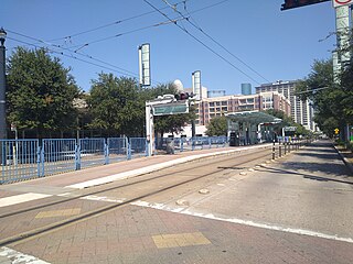
Main Street Square is a station on the METRORail Red Line in Houston, Texas (USA). This originally was the 3rd station heading south along the rail line and is in the heart of downtown. There are many shopping areas and offices nearby. The station is located on Main Street in Downtown Houston and has two separate platforms. The northbound platform is located between the Walker and McKinney Streets, while the southbound platform is located between Lamar and Dallas Streets. These two platforms are divided by the Main Street Square fountain.
McGowen is an island platformed METRORail light rail station in Houston, Texas, United States. The station was opened on January 1, 2004 and is operated by the Metropolitan Transit Authority of Harris County, Texas (METRO). Located in Midtown, this station is at the intersection of Main Street and McGowen Street. The station is split into two platforms: northbound is located on Main north of McGowen and southbound is located on Main south of McGowen.

Burnage railway station is a railway station in south Manchester, England, in the suburb of Burnage on the Styal Line. The station is served by Manchester – Crewe Northern Trains stopping services to Manchester Airport. It caters mainly for commuter traffic, being electrified at 25 kV AC overhead, and is used by EMU traffic.

Dinas Rhondda railway station is a railway station serving the Dinas, Penygraig and Trealaw districts of Tonypandy, Wales. It is located on the Rhondda Line.

Holmes Chapel railway station serves the village of Holmes Chapel in Cheshire, England. The station is 8½ miles (14 km) north east of Crewe on the Crewe to Manchester Line.

Butlers Lane railway station serves the northern part of the Four Oaks district of Sutton Coldfield, England. It is situated on the Cross-City Line. The station, and all trains calling there are operated by West Midlands Trains.

Blake Street railway station serves the Hill Hook area of Sutton Coldfield, Birmingham, England. It is situated on the Cross-City Line, located on the county boundary between the West Midlands and Staffordshire. The station is managed by West Midlands Trains, who operate all trains serving it.

Wem railway station serves the town of Wem in Shropshire, England. The station is 10¾ miles (17 km) north of Shrewsbury on the Welsh Marches Line to Crewe.

The Red Line is one of three light rail routes on the METRORail network operated by METRO in Houston, Texas. It is the oldest line in the METRORail system, with the first 7.5-mile (12.1 km) section of the line between Fannin South and UH–Downtown opening on January 1, 2004.

UCSF Medical Center station is a light rail station on the Muni Metro T Third Street line, located in the median of Third Street at Mariposa Street in the Mission Bay neighborhood of San Francisco, California. The station serves the UCSF Medical Center and the larger UCSF Mission Bay campus. The station opened with the T Third Street line on January 13, 2007. It has two side platforms; the northbound platform is north of Mariposa Street, and the southbound platform south of Mariposa Street, which allows trains to pass through the intersection before stopping at the station.

20th Street station is a light rail station on the Muni Metro T Third Street line in the Dogpatch neighborhood of San Francisco, California. The station opened with the T Third Street line on January 13, 2007. It has two side platforms; the northbound platform is north of 20th Street, and the southbound platform south of 20th Street, so that trains can pass through the intersection before the station stop.

23rd Street station is a light rail station on the Muni Metro T Third Street line, located in the median of Third Street in the Dogpatch neighborhood of San Francisco, California. The station opened with the T Third Street line on January 13, 2007. It has two side platforms; the northbound platform is north of 23rd Street, and the southbound platform south of 23rd Street, so that trains can pass through the intersection before the station stop.

Evans station is a light rail station on the Muni Metro T Third Street line, located in the median of 3rd Street at Evans Avenue in the Bayview neighborhood of San Francisco, California. The station opened with the T Third Street line on January 13, 2007. It has two side platforms; the northbound platform is north of Evans Avenue, and the southbound platform south of Evans Avenue so that trains can pass through the intersection before the station stop.

Williams station is a light rail station of the San Francisco Municipal Railway's Muni Metro system located in the median of Third Street at Williams and Van Dyke Avenues in Bayview, San Francisco, California, United States. The station opened along with the T Third Street line on January 13, 2007. It has two side platforms; the northbound platform is north of Williams Avenue, and the southbound platform south of Williams Avenue, so that trains can pass through the intersection before the station stop. A wye for trains to reverse directions is located two blocks south at Armstrong Avenue, allowing Williams station to be the terminus of short turn trains when necessary.

Gilman/Paul station is a light rail station on the Muni Metro T Third Street line, located in the median of Third Street in the Bayview neighborhood of San Francisco, California. The station opened with the T Third Street line on January 13, 2007. It has two side platforms; the northbound platform is north of Gilman Avenue/Paul Avenue, and the southbound platform to the south, so that trains can pass through the intersection before the station stop.

The Burnett Transit Center is an elevated light rail station on the METRORail Red Line in Houston, Texas, United States. It was built as part of the North/Red Line Extension, and opened on December 21, 2013.

Central Station is a light rail station served by METRORail in downtown Houston, Texas, United States. It serves as a major transfer point between the Red, Purple and Green lines. It is the busiest station on the Green and Purple lines.

7th-8th Street & Nicollet is a bus rapid transit station on the Metro C Line and D Line in downtown Minneapolis, Minnesota. The station is located at the intersection of Nicollet Mall, with the northbound platform located on 7th Street and the southbound platform on 8th Street. The platforms are referred to as 7th Street & Nicollet and 8th Street & Nicollet, respectively. The station is located within the Downtown Minneapolis Fare Zone, where riders can travel in the zone for 50¢ with no transfers.
