The Metropolitan Transit Authority of Harris County is a major public transportation agency based in Houston, Texas, United States. It operates bus, light rail, bus rapid transit, HOV and HOT lanes, and paratransit service in the city as well as most of Harris County. It also operates bus service to two cities in Fort Bend County, and to Conroe in Montgomery County. The Metro headquarters are in the Lee P. Brown Administration Building in Downtown Houston. In 2022, the system had a ridership of 60,121,300, or about 225,600 per weekday as of the third quarter of 2023.

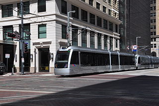
METRORail is the 22.7-mile (36.5 km) light rail system in Houston, Texas. In 2022, the system had a ridership of 12,176,700, or about 44,300 per weekday as of the third quarter of 2023. METRORail ranks as the second most-traveled light rail system in the Southern United States and the 12th most-traveled light rail system in the United States, and has the highest ridership per mile for light rail systems in the Southern US. METRORail is operated by the Metropolitan Transit Authority of Harris County (METRO).
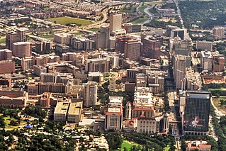
The Texas Medical Center (TMC) is a 2.1-square-mile (5.4 km2) medical district and neighborhood in south-central Houston, Texas, United States, immediately south of the Museum District and west of Texas State Highway 288. Over 60 medical institutions, largely concentrated in a triangular area between Brays Bayou, Rice University, and Hermann Park, are members of the Texas Medical Center Corporation—a non-profit umbrella organization—which constitutes the largest medical complex in the world. The TMC has an extremely high density of clinical facilities for patient care, basic science, and translational research.
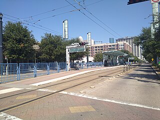
Bell station is a METRORail light rail station in Houston, Texas. The station was opened on January 1, 2004 and is operated by the Metropolitan Transit Authority of Harris County, Texas (METRO). It is located at the intersection of Main Street and Bell Street in Downtown Houston. This is the fourth station heading south along the rail line.

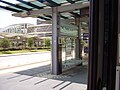
Downtown Transit Center (Houston) is a bus and light rail transportation center in Downtown Houston, Texas, United States, operated by the Metropolitan Transit Authority of Harris County, Texas (METRO). It includes an island platformed METRORail light rail station and bays for bus service.
McGowen is an island platformed METRORail light rail station in Houston, Texas, United States. The station was opened on January 1, 2004 and is operated by the Metropolitan Transit Authority of Harris County, Texas (METRO). Located in Midtown, this station is at the intersection of Main Street and McGowen Street. The station is split into two platforms: northbound is located on Main north of McGowen and southbound is located on Main south of McGowen.
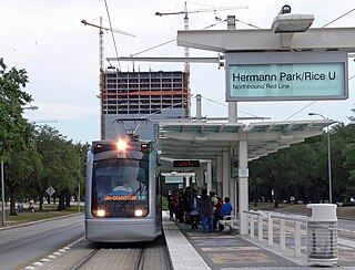
Hermann Park/Rice U is an island platformed METRORail light rail station in south-central Houston, Texas, United States. The station was opened on January 1, 2004, and is operated by the Metropolitan Transit Authority of Harris County (METRO). Located in Hermann Park, it is located at the intersection of Fannin Street and Sunset Boulevard. The station also serves the main entrance of Rice University. Adjacent to the station is a stop on the Hermann Park Railroad, a narrow-gauge recreational sightseeing train for park visitors.

Memorial Hermann Hospital/Houston Zoo Station is an island platformed METRORail light rail station in Houston, Texas, United States. The station was opened on January 1, 2004, and is operated by the Metropolitan Transit Authority of Harris County, Texas (METRO). The station is located at the intersection of Fannin Street and Cambridge Street and serves Memorial Hermann Hospital, the Medical School portion of The University of Texas Health Science Center at Houston and the Houston Zoo. Ben Taub Hospital and Baylor College of Medicine are also within walking distance of the station.

Dryden/TMC Station is an island platformed METRORail light rail station in Houston, Texas, United States. The station was opened on January 1, 2004, and is operated by the Metropolitan Transit Authority of Harris County, Texas (METRO). The station is located within the Texas Medical Center and is located at the intersection of Fannin Street and Dryden Road. Outside of weekends, it is the busiest station on the Red Line and the METRORail network as a whole.
Smith Lands is an island platformed METRORail light rail station in Houston, Texas, United States. The station was opened on January 1, 2004 and is operated by the Metropolitan Transit Authority of Harris County, Texas (METRO). The station is located south of the Texas Medical Center at the intersection of Greenbriar Drive and Colonnade Drive; Old Spanish Trail crosses Greenbriar Drive approximately one block south of the station.

Stadium Park/Astrodome is an island platformed METRORail light rail station in Houston, Texas, United States. The station was opened on January 1, 2004, originally as Reliant Park station, and is operated by the Metropolitan Transit Authority of Harris County, Texas (METRO). The station is located at the intersection of Fannin Street and Holly Hall Street, next to NRG Park. This station is decorated with various photographs from The Astrodome's history including the Rodeo, the Houston Astros and an Elvis concert.

Fannin South is an island platformed METRORail light rail station in Houston, Texas, United States. The station was opened on January 1, 2004, and is operated by the Metropolitan Transit Authority of Harris County, Texas (METRO). Serving as the southern terminus of the Red Line, this is located at the intersection of Fannin Street and West Bellfort Avenue, and is co-located with the Fannin South Park & Ride facility, which is located close to Interstate 610.
The University Line is a planned 25 mi (40 km) bus rapid transit route that would be operated by Metro in Houston, Texas, United States. It replaces a former METRORail light rail line that was proposed in the 2000s and 2010s. The University Line is scheduled to begin construction in 2025 and would be built in five sections between Westchase Park and Ride, Uptown, the University of Houston, and Tidwell Transit Center.
The Red Line is one of three light rail routes on the METRORail network operated by METRO in Houston, Texas. It is the oldest line in the METRORail system, with the first 7.5-mile (12.1 km) section of the line between Fannin South and UH–Downtown opening on January 1, 2004.
The Purple Line is a 6.6-mile (10.6 km) METRORail light rail/streetcar route operated by METRO in Houston, Texas, serving Southeast Houston. The line opened on May 23, 2015.

Quickline is a bus rapid transit service owned and operated by the Metropolitan Transit Authority of Harris County (METRO). The Quickline service began on June 1, 2009 with the 402 route, which supplements the 2-Bellaire route, which was the most heavily used bus route in the METRO system, with that title now belonging to the 82-Westheimer. Both routes run along Bellaire Boulevard.

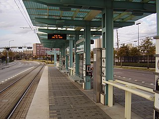
The Burnett Transit Center is an elevated light rail station on the METRORail Red Line in Houston, Texas, United States. It was built as part of the North/Red Line Extension, and opened on December 21, 2013.
Magnolia Park Transit Center is a light rail and bus station in Houston, Texas on the METRORail system. It is the eastern terminus of the Green Line and is located on Harrisburg Boulevard at 70th Street in Magnolia Park, in the East End. Nearby the station are many restaurants and taquerias. The Magnolia Park shopping center is a half block down the street at Harrisburg and Sgt. Macario Garcia Drive.

Project Connect is a transit expansion program by the Capital Metropolitan Transportation Authority in Austin, Texas, U.S. The program was approved by voters on November 3, 2020, in a local election concurrent with the 2020 presidential election.