NOAAS Whiting

Last updated
NOAAS Whiting (S 329).jpg
NOAAS Whiting (S 329)
History
Flag of the United States.svg Flag of the United States Coast and Geodetic Survey.svg United States
NameUSC&GS Whiting (CSS 29)
Namesake Henry Laurens Whiting (1821-1897), U.S. Coast Survey and U.S. Coast and Geodetic Survey employee (1838-1897) and renowned topographic surveyor
Builder Marietta Manufacturing Company, Point Pleasant, West Virginia
Launched20 November 1962
AcquiredJuly 1963 (delivery)
Commissioned8 July 1963
FateTransferred to National Oceanic and Atmospheric Administration 3 October 1970
Flag of the United States.svg NOAA Flag.svg United States
NameNOAAS Whiting (S 329)
NamesakePrevious name retained
AcquiredTransferred from U.S. Coast and Geodetic Survey 3 October 1970
Decommissioned2 May 2003
Homeport Norfolk, Virginia
Identification
FateTransferred to Mexican Navy 28 April 2005
Flag of Mexico.svgMexico
Name
  • 2005-2023 ARM Río Tuxpan (BI-12)
  • from 2023 ARM Amealco (BI-07)
Namesake Tuxpan River
AcquiredTransferred from National Oceanic and Atmospheric Administration 28 April 2005
Commissioned28 April 2005
Identification IMO number:  6601973
StatusActive
General characteristics
Class and typeS1-MT-59a
Type Survey ship
Tonnage
Displacement907 tons
Length49.7 m (163 ft)
Beam10.1 m (33 ft)
Draft
  • 3.4 m (11 ft) (maximum)
  • 3.7 m (12 ft) (with IDSSS dome)
PropulsionTwo geared 800-bhp (597-kW) General Motors diesel engines, two shafts, 4,300 U.S. gallons (16,277 liters fuel)
Speed12.0 knots
Range5,700 nm
Endurance20 days
Crew33 (8 officers, 25 other crew, 2 scientists) plus up to 6 temporarily embarked personnel

NOAAS Whiting (S 329), was an American survey ship that was in commission in the National Oceanic and Atmospheric Administration (NOAA) from 1970 to 2003. Previously, she had been in commission in the United States Coast and Geodetic Survey from 1963 to 1970 as USC&GS Whiting (CSS 29).

Contents

In 2005 the ship was transferred to Mexico, and she was commissioned in the Mexican Navy as ARM Río Tuxpan (BI-12), Mexico's first dedicated hydrographic survey ship, and then renamed ARM Amealco (BI-07) in 2023.

Construction and commissioning

NOAAS Whiting (S 329) NOAAS Whiting (S 329) starboard bow view.jpg
NOAAS Whiting (S 329)

Whiting was built at a cost of $2,300,000 (USD) as a "coastal survey ship" (CSS) for the U.S. Coast and Geodetic Survey by the Marietta Manufacturing Company at Point Pleasant, West Virginia. [1] She was launched on 20 November 1962 and delivered in July 1963. [2] [3] [4] The Coast and Geodetic Survey commissioned her on 8 July 1963 [4] in a ceremony at New Orleans, Louisiana, [5] as USC&GS Whiting (CSS 29), [2] [3] the first and only Coast and Geodetic Survey ship of the name. When the Coast and Geodetic Survey and other United States Government agencies merged to form NOAA on 3 October 1970, Whiting became a part of the NOAA fleet as NOAAS Whiting (S 329), [6] thus far the only NOAA ship to bear the name.

Capabilities

Whiting had a two-drum bathythermograph winch with a maximum pull of 1,000 pounds (454 kg). The lower drum had 3/16-inch (4.75-mm) wire rope, while the upper drum had 13,123 feet (4,000 meters) of 1/4-inch (6.4-mm) wire rope. She had a 27-foot (8.2-meter) telescoping boom with a lifting capacity of 2,500 pounds (1,100 kg) and a 27-foot (8.2-meter) articulating boom with a lifting capacity of 2,768 pounds (1,256 kg), as well as a 16-foot A-frame with a maximum load of 6,250 pounds (2,830 kg) and a working load of 5,000 pounds (2,300 kg). [3]

For acoustic hydrography and bathymetry, Whiting had 12-Khz deep-water echosounder, a 100-kHz shallow-water echosounder-lOOKhz, a 24- and 100-kHz hydrographic survey sounder, and the Intermediate Depth Swath Survey System (IDSSS), which is a 36-kHz sidescan sonar. In 1989 she underwent a major upgrade involving the installation of Hydrochart II, which employed a Microvax computer system to acquire and process hydrographic data. Hydrochart II gave her the capability to generate bottom contour charts with a swath width of approximately two-and-a-half times the water depth, ranging from 10 to 1,000 meters (33 to 3,281 ft), in real time. [3]

Whiting had an ice-strengthened steel hull. [3]

Whiting carried two 29-foot (8.8-meter) aluminum-hulled diesel-powered Jensen survey launches. For utility and rescue purposes, she also carried two open boats with gasoline-powered outboard motors, a 16-foot (4.9-meter) Boston Whaler fiberglass-hulled boat and 17-foot (5.2-meter) Monark aluminum-hulled boat. [3]

At the time of her decommissioning, Whiting was the most technologically advanced hydrographic survey platform in the world. She and her survey launches were outfitted with modern multibeam echosounders and sidescan sonars, allowing efficient and rapid hydrographic surveys. The data storage for survey data was close to 2 terabytes, and nine workstations allowed survey personnel to process the data with state-of-the-art software and create three-dimensional models of the ocean floor, side-scan mosaics, and imagery of historical wrecks. [7]

Operational career

Whiting conducted hydrographic and bathymetric surveys involving nautical charting and ocean mapping, primarily along the United States East Coast and United States Gulf Coast and off territories of the United States in the Caribbean. [1] [8] She also imaged historical wrecks like that of the United States Navy monitor USS Monitor and was used for oceanography, fisheries research, and homeland security surveys. During her 39-year career, her operations took her from as far north as Duluth, Minnesota, to as far south as Honduras in Central America. [7]

John F. Kennedy, Jr., crash

After receiving word that the Piper Saratoga II HP flown by John F. Kennedy, Jr. had disappeared during a flight on the evening of 16 July 1999 and was feared to have crashed in the Atlantic Ocean off Martha's Vineyard, Massachusetts, Whiting, under the command of Lieutenant Commander Gerd F. Glang, interrupted her survey operations in the Delaware Bay on 18 July to make a 24-hour voyage at about 12 knots (14 mph; 22 km/h) to the search area and participate in the search for the aircraft and its passengers. Arriving on the scene on the morning of 19 July 1999, Whiting joined the NOAA survey ship NOAAS Rude (S 590), which had been searching for the wreckage of the aircraft since 17 July using sidescan sonar and multibeam sonar. Whiting brought a more advanced sidescan sonar – only recently installed aboard the ship – to the effort that allowed a higher resolution and a higher search speed. While Whiting searched one area in dense fog, dodging lobster pots, Rude found and marked a high-confidence target in another area that appeared to be the missing Saratoga and radioed the United States Navy rescue and salvage ship USS Grasp (ARS-51) about the discovery; Whiting then searched the same area to gain higher-resolution images of the target. Late on 20 July, U.S. Navy divers from Grasp confirmed that the target was the missing aircraft. Whiting and Rude competed their survey of the crash area on 21 July 1999, then assisted the United States Coast Guard in maintaining security in the area. Later on 21 July, the two ships were released from duty in the crash area, and Whiting set course for Washington, D.C., to take part in the assumption-of-command ceremony for incoming NOAA Corps Director Rear Admiral Evelyn J. Fields at the Washington Navy Yard on 27 July. [9] [10] [11] On 30 July 1999, the U.S. Coast Guard presented personnel involved in the search-and-rescue effort, including the crews of Whiting and Rude, with a commendation

... for exceptionally meritorious service from 17 July 1999 to 23 July 1999 in the search and recovery of the downed aircraft carrying John F. Kennedy, Jr.; his wife, Carolyn Bessette-Kennedy; and her sister Lauren Bessette. Members of the Unified Command distinguished themselves during this complex operation with their professional expertise and poise. [11]

Egyptair Flight 990

Whiting again was operating in the Delaware Bay under Lieutenant Commander Glang's command when Egyptair Flight 990, a Boeing 767-300ER, crashed in the Atlantic Ocean about 40 miles (64 kilometers) south of Nantucket Island, Massachusetts, on 31 October 1999. The U.S. Coast Guard requested her support in the search for the downed aircraft, and she soon got underway for Naval Station Newport, Rhode Island, where she replenished her supplies and refueled before proceeding to the crash area. [12] Arriving on the scene early on 2 November, [13] she put her sidescan sonar to use and discovered the debris field of the crash on the ocean bottom on her first surveying pass, only 12 hours after arriving. After only a day of search operations, however, a gale with 50-knot (58-mph; 93-km/h) winds and 20-foot (6.1-meter) seas forced Whiting and U.S. Navy survey ships in the area to return early on 3 November to Newport, where Whiting's crew compared their survey data with data collected by U.S. Navy ships. [14] A break in the weather allowed Whiting to return on 5 November to continue her bottom-mapping operations; although she had to suspend mapping operations briefly when the towfish containing her sidescan sonar became entangled in a lobster pot and was damaged, her crew was able to improvise a night repair in difficult weather conditions and put the sonar back into service. [15] Whiting's bottom map combined with charts provided by NOAA's Office of Coast Survey allowed the U.S. Navy rescue and salvage ship USS Grapple (ARS-53) to anchor safely over the debris field without disturbing the wreckage. Having completed her Egyptair Flight 990 work and turned over continued mapping and search operations to U.S. Navy remotely operated vehicles, Whiting departed Naval Station Newport on 11 November 1999 to return to her home port at Norfolk, Virginia. [9] [16] [17] [18] [19]

Whiting's first sonar image of the wreck of the U.S. Navy submarine USS S-5 (SS-110) on the bottom of the Atlantic Ocean, made in late July 2001 when Whiting discovered the wreck's exact location for the first time. USS S-5 (S-110) wreck sonar image.jpg
Whiting's first sonar image of the wreck of the U.S. Navy submarine USS S-5 (SS-110) on the bottom of the Atlantic Ocean, made in late July 2001 when Whiting discovered the wreck's exact location for the first time.

USS S-5

In July 2001, NOAA's Office of Ocean Exploration asked Whiting to search for the wreck of the U.S. Navy submarine USS S-5 (SS-110), which sank 15 nautical miles (28 kilometres) off Cape May, New Jersey, in September 1920. Whiting, which had just completed a summer in port at Norfolk, Virginia, and was bound for Boston, Massachusetts, to conduct hydrographic survey operations in New England, paused off Cape May in late July 2001 to search for the wreck. Whiting's survey department approached the project as it would any typical hydrographic survey. Information on snags – obstructions on the ocean bottom that snarl fishing nets and gear – that local recreational fishermen had reported and reports of possible locations of the wreck from divers that had visited it provided Whiting with possible targets for her search. After her crew had prepared a plan for a systematic search, Whiting moved from target cluster to target cluster, mapping the ocean bottom using sidescan sonar. After eight hours of searching, Whiting found the wreck of S-5 directly over one of the suspected targets, made a sonar image of the wreck, and recorded its exact location. Whiting then made several more passes over the wreck to acquire additional images of it at various angles before leaving the scene. NOAA donated the sonar data NOAAS Whiting gathered to the Submarine Force Library and Museum in Groton, Connecticut, for archiving and display. [20]

Decommissioning

Whiting made her final cruise in NOAA service in 2002, when she deployed to the United States Virgin Islands, the Gulf of Mexico, and the southeast coast of the United States in support of homeland security and nautical charting. She returned in November 2002, bringing an end to 39 years of service. [7]

Finding the aging Whiting no longer economical to operate, NOAA decommissioned her on 2 May 2003. [7] NOAA replaced her with the survey ship NOAAS Thomas Jefferson (S 222). [21]

ARM Rio Tuxpan (BI-12) pierside on the Elizabeth River at Town Point Park in Norfolk, Virginia, on 28 April 2005, the day of her transfer to Mexico and commissioning into Mexican Navy service. ARM Rio Tuxpan (BI-12).jpg
ARM Río Tuxpan (BI-12) pierside on the Elizabeth River at Town Point Park in Norfolk, Virginia, on 28 April 2005, the day of her transfer to Mexico and commissioning into Mexican Navy service.

Mexican Navy service

After Whiting was decommissioned, the United States Congress authorized her transfer to Mexico with the stipulation that Mexico employ her in supporting the hydrographic activities of the United States-Mexico Cooperative Charting Advisory Committee so as to enhance cooperation between the United States and Mexico in surveying and charting the border waters of both countries in the Gulf of Mexico and in the Pacific Ocean. Accordingly, by the authority of the United States Secretary of Commerce, Whiting was transferred to Mexico in a ceremony at Norfolk, Virginia, on 28 April 2005. Mexico immediately commissioned her into service in the Mexican Navy as ARM Río Tuxpan (BI-12), Mexico's first dedicated hydrographic survey ship. [22] In 2023 the ship was renamed ARM Amealco (BI-07). [23]

See also

Related Research Articles

<span class="mw-page-title-main">Hydrographic survey</span> Science of measurement and description of features which affect maritime activities

Hydrographic survey is the science of measurement and description of features which affect maritime navigation, marine construction, dredging, offshore wind farms, offshore oil exploration and drilling and related activities. Surveys may also be conducted to determine the route of subsea cables such as telecommunications cables, cables associated with wind farms, and HVDC power cables. Strong emphasis is placed on soundings, shorelines, tides, currents, seabed and submerged obstructions that relate to the previously mentioned activities. The term hydrography is used synonymously to describe maritime cartography, which in the final stages of the hydrographic process uses the raw data collected through hydrographic survey into information usable by the end user.

USS <i>S-5</i> Submarine of the United States

USS S-5 (SS-110) was a "Government-type" S-class submarine of the United States Navy. Her keel was laid down on 4 December 1917 by the Portsmouth Navy Yard of Kittery, Maine. She was launched on 10 November 1919, sponsored by Mrs. Glenn S. Burrell, and commissioned on 6 March 1920 with Lieutenant Commander Charles M. "Savvy" Cooke, Jr., in command. She sank accidentally during full-power trials on 1 September 1920, but due to actions by her crew and the crews of other ships, there were no deaths. Refloated, she was lost when she sank again while under tow on 3 September 1920.

<span class="mw-page-title-main">Sonobuoy</span> Expendable sonar system dropped/ejected from aircraft or ships

A sonobuoy is a small expendable sonar buoy dropped from aircraft or ships for anti-submarine warfare or underwater acoustic research. Sonobuoys are typically around 13 cm (5 in) in diameter and 91 cm (3 ft) long. When floating on the water, sonobuoys have both a radio transmitter above the surface and hydrophone sensors underwater.

<span class="mw-page-title-main">Office of Marine and Aviation Operations</span> US platforms operated by NOAA

The Office of Marine and Aviation Operations (OMAO) is a division of the National Oceanic and Atmospheric Administration (NOAA) which operates a wide variety of specialized ships and aircraft to carry out the environmental and scientific missions of NOAA.

NOAAS <i>Rude</i>

NOAAS Rude was an American Rude-class hydrographic survey ship that was in commission in the National Oceanic and Atmospheric Administration (NOAA) from 1970 to 2008. Prior to its NOAA career, it was in commission in the United States Coast and Geodetic Survey from 1967 to 1970 as USC&GS Rude. It was named for Gilbert T. Rude, former Chief of the Division of Coastal Surveys of the Coast and Geodetic Survey.

NOAAS <i>Fairweather</i> US Research and hydrographic survey ship based in Alaska (1967)

NOAA Ship Fairweather, originally operated by the United States Coast and Geodetic Survey as USC&GS Fairweather, is an oceanographic research ship operated by the National Oceanic and Atmospheric Administration (NOAA). Fairweather primarily conducts hydrographic surveys in Alaskan waters, but is considered a multi-mission-capable vessel and has conducted fisheries research cruises. She is the sister ship of the NOAAS Rainier and of the retired NOAAS Mount Mitchell.

NOAAS <i>Thomas Jefferson</i>

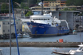
NOAAS Thomas Jefferson is a National Oceanic and Atmospheric Administration (NOAA) hydrographic survey vessel in service since 2003. The ship was built for the United States Navy as USNS Littlehales (T-AGS-52) serving as one of two new coastal hydrographic survey vessels from 1992 until transfer to NOAA in 2003 when it was named after Founding Father and third U.S. president, Thomas Jefferson.

NOAAS <i>Mount Mitchell</i>

NOAAS Mount Mitchell was an American survey vessel in commission in the National Oceanic and Atmospheric Administration from 1970 to 1995. Prior to her NOAA career, she was in commission in the United States Coast and Geodetic Survey as USC&GS Mount Mitchell from 1968 to 1970. In 2003, she returned to service as the private research ship R/V Mt. Mitchell.

<span class="mw-page-title-main">United States Coast and Geodetic Survey</span> Former U.S. government scientific agency

The United States Coast and Geodetic Survey, known from 1807 to 1836 as the Survey of the Coast and from 1836 until 1878 as the United States Coast Survey, was the first scientific agency of the United States Government. It existed from 1807 to 1970, and throughout its history was responsible for mapping and charting the coast of the United States, and later the coasts of U.S. territories. In 1871, it gained the additional responsibility of surveying the interior of the United States and geodesy became a more important part of its work, leading to it being renamed the U.S. Coast and Geodetic Survey in 1878.

USC&GS <i>Carlile P. Patterson</i>

USC&GS Carlile P. Patterson was a survey ship of the United States Coast and Geodetic Survey in operation between 1883 and 1918. Subsequently, she had a brief period of naval service and fifteen seasons as a merchant vessel before she was wrecked on the Alaska coast in 1938.

USS <i>Mobjack</i> Tender of the United States Navy

USS Mobjack (AVP-27/AGP-7) was a motor torpedo boat tender in commission in the United States Navy from 1943 to 1946. She saw service in the Pacific theater during the latter portion of World War II.

USCS <i>Robert J. Walker</i>

USCS Robert J. Walker was a survey ship that served in the United States Coast Survey, a predecessor of the United States Coast and Geodetic Survey, from 1848 until sinking in 1860 after a collision at sea. Her loss resulted in the death of 20 men, the greatest loss of life in single incident ever to befall the National Oceanic and Atmospheric Administration or any of its ancestor agencies. It was added to the National Register of Historic Places on March 19, 2014.

NOAAS <i>Heck</i>

NOAAS Heck was a Rude-class hydrographic survey ship in the National Oceanic and Atmospheric Administration (NOAA) from 1970 to 1995. Prior to her NOAA service, she was in commission from 1967 to 1970 in the United States Coast and Geodetic Survey as USC&GS Heck.

NOAAS <i>Davidson</i> NOAA survey ship

NOAAS Davidson was a survey ship in commission in the National Oceanic and Atmospheric Administration (NOAA) from 1970 to 1989. Prior to her NOAA service, she was in commission in the United States Coast and Geodetic Survey from 1967 to 1970 as USC&GS Davidson, the second Coast and Geodetic Survey ship of the name. She was the only sister ship of NOAAS McArthur (S 330).

USCS Phoenix was a schooner which served as a survey ship in the United States Coast Survey from 1845 to 1857.

SS <i>City of Chester</i>

The SS City of Chester was a steamship built in 1875 that sank after a collision in a dense fog with SS Oceanic at the Golden Gate in San Francisco Bay on August 22, 1888. She was owned by the Oregon Railroad Co. and leased by the Pacific Coast Steamship Company.

USC&GS <i>Explorer</i> (OSS 28)

The second USC&GS Explorer was a survey ship that served in the United States Coast and Geodetic Survey from 1940 to 1968. She operated in the Pacific Ocean from 1940 to 1960, seeing service there during World War II, and in the Atlantic Ocean from 1960 to 1968.

NOAAS <i>Peirce</i>

NOAAS Peirce, was an American survey ship that was in commission in the National Oceanic and Atmospheric Administration (NOAA) from 1970 to 1992. Previously, she had been in commission in the United States Coast and Geodetic Survey from 1963 to 1970 as USC&GS Peirce.

NOAAS <i>Oscar Dyson</i>

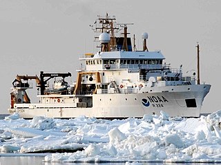
NOAAS Oscar Dyson is an American fisheries and oceanographic research vessel in commission in the National Oceanic and Atmospheric Administration (NOAA) fleet since 2005.

<span class="mw-page-title-main">Nicholas H. Heck</span> American USCGSC officer (1882–1953)

Captain Nicholas Hunter Heck was a career officer of the United States Coast and Geodetic Survey Corps. A leading geophysicist of his time, Heck made important contributions in the study of seismology and oceanography. He also revolutionized hydrographic surveying by developing the wire-drag surveying technique and introduced radio acoustic ranging into Coast and Geodetic Survey hydrography.

References

Notes

  1. 1 2 NOAA History: Coast and Geodetic Survey Ships: Whiting
  2. 1 2 Appendix E, pp. 12-16.
  3. 1 2 3 4 5 6 Ships of the NOAA Fleet, Rockville, Maryland: United States Department of Commerce, June 1989
  4. 1 2 Polmar, Norman, The Naval Institute Guide to the Ships and Aircraft of the U.S. Fleet, Seventeenth Edition, Naval Institute Press: Annapolis, Maryland, 2001, ISBN   1-55750-656-6, p. 614.
  5. Invitation to commissioning ceremony of USC&GS Ship WHITING on July 8, 1963
  6. researchvessels.org NOAA Ship WHITING - S329
  7. 1 2 3 4 greenenvironmentnews.com NOAA News: "N.O.A.A. Ship Whiting Decommissioned after 39 Years of Service," May 2, 2003.
  8. NOAA Marine Operations Center: NOAA Ship Whiting
  9. 1 2 Steelhammer, Rick, It Happened in West Virginia: Remarkable Events That Shaped History, First Edition, Guilford, Connecticut: Globe Pequot Press, 2013. ISBN   978-0-7627-7054-0.
  10. noaa.gov Disaster Response: NOAA Ships, Planes, and Officers Offer Valuable Capabilities: JFK, Jr. Airplane Crash: July 16, 1999
  11. 1 2 Konop, Dane, "A Behind the Scenes Look: NOAA Ships Survey, Locate JFK Jr. Plane," history.noaa.gov, undated.
  12. Anonymous, "NOAA SHIP WHITING TO JOIN EGYPTAIR FLIGHT 990 SEARCH", NOAA News, November 1, 1999.
  13. Anonymous, "NOAA SHIP WHITING BEGINS ITS SEARCH FOR EGYPTAIR FLIGHT 990", NOAA News, November 2, 1999.
  14. Anonymous, "BAD WEATHER HAMPERS NOAA SHIP WHITING EGYPTAIR SEARCH", NOAA News, November 3, 1999.
  15. Anonymous, "NOAA SHIP WHITING CONTINUES TO SEARCH FOR EGYPTAIR FLIGHT 990", NOAA News, November 5, 1999.
  16. Anonymous, "NOAA COMPLETES ITS MISSION IN EGYPTAIR 990 INVESTIGATION", NOAA News, November 16, 1999.
  17. Chartuk, Robert, "NOAA Team Responds to Egyptair Crash," NOAA Report, January 2000, pp. 3, 6.
  18. noaa.gov NOAA News: "NOAA COMPLETES ITS MISSION IN EGYPTAIR 990 INVESTIGATION," November 16, 1999.
  19. Disaster Response: NOAA Ships, Planes, and Officers Offer Valuable Capabilities: Egypt Air Flight 990 Plane Crash: October 31, 1999
  20. Weirich, Jeremy B., LTJG, "How the NOAA Ship Whiting Found the USS S-Five," oceanexplorer.noaa.gov, undated.
  21. Wertheim, p. 1008.
  22. noaa.gov NOAA News: "NOAA Transfers Mapping Ship to Mexican Navy," May 3, 2005.
  23. "Acuerdos Secretariales para Unidades de Superficie" (PDF) (in Spanish). Armada de Mexico. January 2023. Archived (PDF) from the original on 22 February 2024. Retrieved 22 February 2024.

Bibliography