
Botetourt County is a US county that lies in the Roanoke Region of the Commonwealth of Virginia. Located in the mountainous portion of the state, the county is bordered by two major ranges, the Blue Ridge Mountains and the Appalachian Mountains.

Crimora is a census-designated place (CDP) in Augusta County, Virginia, United States. The population was 2,209 at the 2010 census, a 23% increase from the 1,796 reported in 2000. It is part of the Staunton–Waynesboro Micropolitan Statistical Area.

Troutville is a town in Botetourt County, Virginia, United States. The population was 458 at the 2020 census. The town is located along the U.S. Route 11 between Cloverdale and Buchanan. It is part of the Roanoke Metropolitan Statistical Area.

Shenandoah is a town in Page County, Virginia, United States. The population was 2,373 at the 2010 census.

The Shenandoah Valley is a geographic valley and cultural region of western Virginia and the Eastern Panhandle of West Virginia in the United States. The valley is bounded to the east by the Blue Ridge Mountains, to the west by the eastern front of the Ridge-and-Valley Appalachians, to the north by the Potomac River and to the south by the James River. The cultural region covers a larger area that includes all of the valley plus the Virginia highlands to the west, and the Roanoke Valley to the south. It is physiographically located within the Ridge and Valley province and is a portion of the Great Appalachian Valley.

The Norfolk and Western Railway, commonly called the N&W, was a US class I railroad, formed by more than 200 railroad mergers between 1838 and 1982. It was headquartered in Roanoke, Virginia, for most of its existence. Its motto was "Precision Transportation"; it had a variety of nicknames, including "King Coal" and "British Railway of America". In 1986, N&W merged with Southern Railway to form today’s Norfolk Southern Railway.

Frederick James Kimball was a civil engineer. He was an early president of the Norfolk and Western Railway and helped develop the Pocahontas coalfields in Virginia and West Virginia.
Midlothian is an unincorporated area and Census-designated place in Chesterfield County, Virginia, U.S. Settled as a coal town, Midlothian village experienced suburbanization effects and is now part of the western suburbs of Richmond, Virginia south of the James River in the Greater Richmond Region. Because of its unincorporated status, Midlothian has no formal government, and the name is used to represent the original small Village of Midlothian and a vast expanse of Chesterfield County in the northwest portion of Southside Richmond served by the Midlothian post office.
Shenandoah Valley Railroad was a line completed on June 19, 1882, extending up the Shenandoah Valley from Hagerstown, Maryland through the West Virginia panhandle into Virginia to reach Roanoke, Virginia and to connect with the Norfolk and Western Railway (N&W). The development of this railroad had considerable backing from the Pennsylvania Railroad. In September 1890 it went into bankruptcy and was reorganized as the Shenandoah Valley Railway. In December 1890, it became part of N&W. Today the tracks are a major artery of the Norfolk Southern system.
The Roanoke Valley in southwest Virginia is an area adjacent to and including the Roanoke River between the Blue Ridge Mountains to the east and the Appalachian Plateau to the west. The valley includes much of Roanoke County, as well as the two independent cities of Roanoke and Salem.
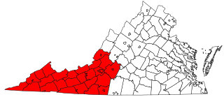
Southwest Virginia, often abbreviated as SWVA, is a mountainous region of Virginia in the westernmost part of the commonwealth. Located within the broader region of western Virginia, Southwest Virginia has been defined alternatively as all Virginia counties on the Appalachian Plateau, all Virginia counties west of the Eastern Continental Divide, or at its greatest expanse, as far east as Blacksburg and Roanoke. Another geographic categorization of the region places it as those counties within the Tennessee River watershed. Regardless of how borders are drawn, Southwest Virginia differs from the rest of the commonwealth in that its culture is more closely associated with Appalachia than the other regions of Virginia. Historically, the region has been and remains a rural area, but in the 20th century, coal mining became an important part of its economy. With the decline in the number of coal jobs and the decline of tobacco as a cash crop, Southwest Virginia is increasingly turning to tourism as a source of economic development. Collectively, Southwest Virginia's craft, music, agritourism and outdoor recreation are referred to as the region's "creative economy."

In the U.S. state of Virginia, U.S. Route 220 (US 220) is a major north-south state highway that extends from the North Carolina state line through Roanoke to the West Virginia state line. South of Roanoke, US 220 is a four-lane highway within the proposed Interstate 73 (I-73) corridor. US 220 narrows to two lanes north of Roanoke, connecting to I-64 near Clifton Forge and then paralleling the Appalachian Mountains north-northeasterly in the direction of Cumberland, Maryland.

Interstate 81 (I-81) is an 855.02-mile-long (1,376.02 km) Interstate Highway. In the US state of Virginia, I-81 runs for 324.92 miles (522.91 km), making the portion in Virginia longer than any other state's portion of the route. It is also the longest Interstate Highway within the borders of Virginia. It stretches from the Tennessee state line near Bristol to the West Virginia state line near Winchester. It enters Virginia from Bristol, Tennessee, and leaves Virginia into Berkeley County, West Virginia. The route passes through the cities of Bristol, Roanoke, Lexington, Staunton, and Harrisonburg.

The Huckleberry Trail is a multipurpose trail that measures almost 15 miles in length in Montgomery County, Virginia, connecting the towns of Blacksburg and Christiansburg. The trail is 12 feet (3.7 m) wide with an asphalt surface.
Springwood is an unincorporated community in Botetourt County, Virginia, United States. Located in the northern part of the Roanoke Valley and at the southern tip of the Shenandoah Valley, Springwood is part of the Roanoke Metropolitan Area and sits along the banks of the James River.

Paint Bank is an unincorporated community in northern Craig County, Virginia, United States. It is located at the intersection of State Route 18 and State Route 311 northwest of the town of New Castle, the county seat. The village is located between Potts Mountain and Peters Mountain. It is one of the westernmost communities of the Roanoke metropolitan area.

Manganese is a ghost town and former mining community in the U.S. state of Minnesota that was inhabited between 1912 and 1960. It was built in Crow Wing County on the Cuyuna Iron Range in sections 23 and 28 of Wolford Township, about 2 miles (3 km) north of Trommald, Minnesota. After its formal dissolution, Manganese was absorbed by Wolford Township; the former town site is located between Coles Lake and Flynn Lake. First appearing in the U.S. Census of 1920 with an already dwindling population of 183, the village was abandoned by 1960.
The Roanoke Region is the area of the Commonwealth of Virginia surrounding the city of Roanoke. Its usage may refer to the metropolitan statistical area or the Roanoke Valley, but it sometimes includes areas in the Allegheny Mountains and New River Valley which includes Alleghany County, Montgomery County, Covington, Clifton Forge, Blacksburg, Christiansburg, and Radford. Bedford County and Floyd County are sometimes included as part of the region.
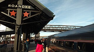
Roanoke station is a train station in Roanoke, Virginia, the current southern terminus of Amtrak's Northeast Regional line. Built in 2017, it follows several other Roanoke passenger stations that operated from the 1850s to 1979. The unstaffed station consists of a single high-level platform with no station building or waiting room available for passengers. All tickets must be purchased in advance; there is no Quik-Trak kiosk at the station.
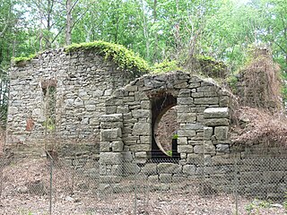
John Thomas Anderson was a nineteenth-century American lawyer, iron manufacturer and politician who served in both chambers of the Virginia General Assembly, representing Botetourt and nearby counties.


