National Register of Historic Places listings in Bullitt County, Kentucky

Last updated

Location of Bullitt County in Kentucky Map of Kentucky highlighting Bullitt County.svg
Location of Bullitt County in Kentucky

This is a list of the National Register of Historic Places listings in Bullitt County, Kentucky.

Contents

It is intended to be a complete list of the properties and districts on the National Register of Historic Places in Bullitt County, Kentucky, United States. The locations of National Register properties and districts for which the latitude and longitude coordinates are included below, may be seen in an online map. [1]

There are 10 properties and districts listed on the National Register in the county.


    This National Park Service list is complete through NPS recent listings posted March 4, 2022. [2]

Map all coordinates using: OpenStreetMap  
Download coordinates as: KML

Current listings

[3] Name on the RegisterImageDate listed [4] Location City or townDescription
1 Ashworth Rock Shelters Site September 11, 1975
(#75000739)
At the foot of McDonald's Knob, along Floyds Fork [5]
38°00′45″N85°41′45″W / 38.012500°N 85.695833°W / 38.012500; -85.695833 (Ashworth Rock Shelters Site)
Shepherdsville
2 Bank of the Commonwealth
Bank of the Commonwealth Bank of the Commonwealth, Shepherdsville, KY 1.jpg
Bank of the Commonwealth
January 8, 1987
(#87000173)
Buckman St.
37°59′13″N85°43′02″W / 37.986944°N 85.717222°W / 37.986944; -85.717222 (Bank of the Commonwealth)
Shepherdsville
3 Henry J. Barnes House
Henry J. Barnes House Barnes perspective.jpg
Henry J. Barnes House
March 1, 1993
(#93000049)
144 N. Bardstown Rd.
38°02′55″N85°32′32″W / 38.048611°N 85.542222°W / 38.048611; -85.542222 (Henry J. Barnes House)
Mount Washington
4 T. Jeremiah Beam House October 15, 1987
(#87001854)
Big Level Rd.
37°55′51″N85°39′12″W / 37.930833°N 85.653333°W / 37.930833; -85.653333 (T. Jeremiah Beam House)
Clermont
5 Solomon Neill Brooks House
Solomon Neill Brooks House Solomon Neill Brooks House.jpg
Solomon Neill Brooks House
April 10, 1980
(#80001488)
4893 North Preston Highway, Shepherdsville (N of Shepherdsville) at John Harper (KY 1526) and Preston Highways (KY 61), south of and adjacent to Schoppenhorst Underwood-Brooks funeral home
38°03′09″N85°40′48″W / 38.0525°N 85.68°W / 38.0525; -85.68 (Solomon Neill Brooks House)
Shepherdsville
6 Henry Crist House January 8, 1987
(#87000215)
Maraman Ln. off Kentucky Route 1604
37°57′22″N85°34′09″W / 37.956111°N 85.569167°W / 37.956111; -85.569167 (Henry Crist House)
Brownington
7 Lebanon Junction Historic District December 4, 2003
(#03001224)
Roughly bounded by Maple St., Kentucky Route 61, Knoxville Ave., and Harrel and Masden Sts.
37°49′55″N85°43′53″W / 37.831944°N 85.731389°W / 37.831944; -85.731389 (Lebanon Junction Historic District)
Lebanon Junction
8 James M. Lloyd House
James M. Lloyd House Lloyd house.jpg
James M. Lloyd House
February 11, 1993
(#93000048)
Northeastern corner of the junction of U.S. Route 31E and East St.
38°02′51″N85°32′25″W / 38.0475°N 85.540278°W / 38.0475; -85.540278 (James M. Lloyd House)
Mount Washington
9 Louisville to Bardstown Turnpike Milestones and Roadbed July 12, 2019
(#100004215)
Along and near US 31E from Louisville to Bardstown
38°03′10″N85°32′14″W / 38.0528°N 85.5373°W / 38.0528; -85.5373 (Louisville to Bardstown Turnpike Milestones and Roadbed)
Louisville
10 Zack Stansbury House
Zack Stansbury House Zack Stansbury House.jpg
Zack Stansbury House
February 11, 1993
(#93000047)
1430 Bardstown Rd.
38°01′59″N85°31′43″W / 38.033056°N 85.528611°W / 38.033056; -85.528611 (Zack Stansbury House)
Mount Washington

See also

Related Research Articles

National Register of Historic Places listings in Jefferson County, Kentucky

The table below includes sites listed on the National Register of Historic Places (NRHP) in Jefferson County, Kentucky except those in the following neighborhoods/districts of Louisville: Anchorage, Downtown, The Highlands, Old Louisville, Portland and the West End. Links to tables of listings in these other areas are provided below.

National Register of Historic Places listings in Woodford County, Kentucky

This is a list of the National Register of Historic Places listings in Woodford County, Kentucky.

National Register of Historic Places listings in Shelby County, Kentucky

This is a list of the National Register of Historic Places listings in Shelby County, Kentucky.

National Register of Historic Places listings in Hardin County, Kentucky

This is a list of the National Register of Historic Places listings in Hardin County, Kentucky.

National Register of Historic Places listings in Greenup County, Kentucky

This is a list of the National Register of Historic Places listings in Greenup County, Kentucky.

National Register of Historic Places listings in Boyle County, Kentucky

This is a list of the National Register of Historic Places listings in Boyle County, Kentucky.

National Register of Historic Places listings in Daviess County, Kentucky

This is a list of the National Register of Historic Places listings in Daviess County, Kentucky.

National Register of Historic Places listings in Clark County, Kentucky

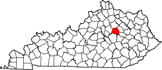
This is a list of the National Register of Historic Places listings in Clark County, Kentucky.

National Register of Historic Places listings in Trimble County, Kentucky Wikipedia list article

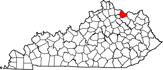
This is a list of the National Register of Historic Places listings in Trimble County, Kentucky.

National Register of Historic Places listings in Spencer County, Kentucky

This is a list of the National Register of Historic Places listings in Spencer County, Kentucky.

National Register of Historic Places listings in Pulaski County, Kentucky

This is a list of the National Register of Historic Places listings in Pulaski County, Kentucky.

National Register of Historic Places listings in Mason County, Kentucky

This is a list of the National Register of Historic Places listings in Mason County, Kentucky.

National Register of Historic Places listings in Meade County, Kentucky

This is a list of the National Register of Historic Places listings in Meade County, Kentucky.

National Register of Historic Places listings in Madison County, Kentucky

This is a list of the National Register of Historic Places listings in Madison County, Kentucky.

National Register of Historic Places listings in Muhlenberg County, Kentucky

This is a list of the National Register of Historic Places listings in Muhlenberg County, Kentucky.

National Register of Historic Places listings in Nelson County, Kentucky

This is a list of the National Register of Historic Places listings in Nelson County, Kentucky.

National Register of Historic Places listings in Oldham County, Kentucky

This is a list of the National Register of Historic Places listings in Oldham County, Kentucky.

National Register of Historic Places listings in Floyd County, Kentucky

This is a list of the National Register of Historic Places listings in Floyd County, Kentucky.

National Register of Historic Places listings in Henry County, Kentucky

This is a list of the National Register of Historic Places listings in Henry County, Kentucky.

National Register of Historic Places listings in Ballard County, Kentucky

This is a list of the National Register of Historic Places listings in Ballard County, Kentucky.

References

  1. The latitude and longitude information provided in this table was derived originally from the National Register Information System, which has been found to be fairly accurate for about 99% of listings. Some locations in this table may have been corrected to current GPS standards.
  2. National Park Service, United States Department of the Interior, "National Register of Historic Places: Weekly List Actions", retrieved March 4, 2022.
  3. Numbers represent an alphabetical ordering by significant words. Various colorings, defined here, differentiate National Historic Landmarks and historic districts from other NRHP buildings, structures, sites or objects.
  4. The eight-digit number below each date is the number assigned to each location in the National Register Information System database, which can be viewed by clicking the number.
  5. Location derived from DiBlasi, Philip James. A New Assessment of the Archaeological Significance of the Ashworth Site (15Bu236). Diss. U of Louisville: 1981, 7. The NRIS lists the site as "Address Restricted".