National Register of Historic Places listings in Jackson County, Illinois

Last updated

Location of Jackson County in Illinois Map of Illinois highlighting Jackson County.svg
Location of Jackson County in Illinois

This is a list of the National Register of Historic Places listings in Jackson County, Illinois.

Contents

This is intended to be a complete list of the properties and districts on the National Register of Historic Places in Jackson County, Illinois, United States. Latitude and longitude coordinates are provided for many National Register properties and districts; these locations may be seen together in a map. [1]

There are 18 properties and districts listed on the National Register in the county. Another property was once listed but has been removed.


    This National Park Service list is complete through NPS recent listings posted October 27, 2023. [2]

Map all coordinates using: OpenStreetMap

Current listings

[3] Name on the RegisterImageDate listed [4] Location City or townDescription
1 Cleiman Mound and Village Site
Cleiman Mound and Village Site Cleiman Mound with village.jpg
Cleiman Mound and Village Site
October 18, 1977
(#77000487)
Northeast of the junction of Big Lake and Thomas Town Rds. [5]
37°47′12″N89°32′05″W / 37.786667°N 89.534722°W / 37.786667; -89.534722 (Cleiman Mound and Village Site)
Gorham
2 R. Buckminster Fuller and Anne Hewlett Dome Home
R. Buckminster Fuller and Anne Hewlett Dome Home Preserved R Buckminster Fuller and Anne Hewlitt Dome Home.jpg
R. Buckminster Fuller and Anne Hewlett Dome Home
February 9, 2006
(#06000012)
407 S. Forest Ave.
37°43′23″N89°13′31″W / 37.723056°N 89.225278°W / 37.723056; -89.225278 (R. Buckminster Fuller and Anne Hewlett Dome Home)
Carbondale
3 Giant City Stone Fort Site
Giant City Stone Fort Site Stone Fort Wall.jpg
Giant City Stone Fort Site
August 9, 2002
(#02000848)
Stone Fort Rd.
37°37′24″N89°11′50″W / 37.623333°N 89.197222°W / 37.623333; -89.197222 (Giant City Stone Fort Site)
Makanda
4 Grand Tower Mining, Manufacturing and Transportation Company Site
Grand Tower Mining, Manufacturing and Transportation Company Site Grand Tower Park hillside.jpg
Grand Tower Mining, Manufacturing and Transportation Company Site
April 13, 1979
(#79000839)
Devil's Backbone Park
37°38′06″N89°30′30″W / 37.635000°N 89.508333°W / 37.635000; -89.508333 (Grand Tower Mining, Manufacturing and Transportation Company Site)
Grand Tower
5 Grange Hall
Grange Hall Grange hall in Somerset Township.jpg
Grange Hall
May 4, 1990
(#90000722)
Illinois Routes 13/127 south of Beaucoup Creek
37°49′10″N89°19′19″W / 37.819583°N 89.321944°W / 37.819583; -89.321944 (Grange Hall)
Murphysboro
6 Robert W. Hamilton House
Robert W. Hamilton House Robert W. Hamilton House.jpg
Robert W. Hamilton House
March 5, 1982
(#82002540)
203 S. 13th St.
37°45′47″N89°20′13″W / 37.762917°N 89.336806°W / 37.762917; -89.336806 (Robert W. Hamilton House)
Murphysboro
7 Cornelius Hennessy Building
Cornelius Hennessy Building Cornelius Hennessy Building.jpg
Cornelius Hennessy Building
November 8, 2000
(#00001331)
1023 Chestnut St.
37°45′48″N89°20′07″W / 37.763472°N 89.335167°W / 37.763472; -89.335167 (Cornelius Hennessy Building)
Murphysboro
8 William H. Hull House
William H. Hull House William H. Hull House in Murphysboro.jpg
William H. Hull House
February 1, 2006
(#05001602)
1517 Walnut St.
37°45′51″N89°20′25″W / 37.764167°N 89.340278°W / 37.764167; -89.340278 (William H. Hull House)
Murphysboro
9 Illinois Central Railroad Passenger Depot
Illinois Central Railroad Passenger Depot IL Central depot in Carbondale.jpg
Illinois Central Railroad Passenger Depot
May 9, 2002
(#02000457)
111 S. Illinois Ave.
37°43′36″N89°12′59″W / 37.726667°N 89.216389°W / 37.726667; -89.216389 (Illinois Central Railroad Passenger Depot)
Carbondale
10 Jackson County Courthouse
Jackson County Courthouse Jackson County Courthouse in Murphysboro from west.jpg
Jackson County Courthouse
December 29, 2015
(#15000931)
1001 Walnut St.
37°45′51″N89°20′06″W / 37.764230°N 89.334934°W / 37.764230; -89.334934 (Jackson County Courthouse)
Murphysboro
11 Liberty Theater
Liberty Theater Liberty Theater in Murphysboro.jpg
Liberty Theater
June 13, 2012
(#12000322)
1333 Walnut St.
37°45′51″N89°20′16″W / 37.764167°N 89.337778°W / 37.764167; -89.337778 (Liberty Theater)
Murphysboro
12 Mobile and Ohio Railroad Depot
Mobile and Ohio Railroad Depot M&O depot in Murphysboro.jpg
Mobile and Ohio Railroad Depot
November 13, 1984
(#84000317)
1701 Walnut St.
37°45′51″N89°20′31″W / 37.764167°N 89.341944°W / 37.764167; -89.341944 (Mobile and Ohio Railroad Depot)
Murphysboro
13 Murphysboro Downtown Historic District
Murphysboro Downtown Historic District Downtown Murhpysboro (35321651176).jpg
Murphysboro Downtown Historic District
December 20, 2022
(#100008487)
Roughly bounded by 9th, 15th, Locust, and Chestnut Sts.
37°45′51″N89°20′09″W / 37.7643°N 89.3359°W / 37.7643; -89.3359 (Murphysboro Downtown Historic District)
Murphysboro
14 Murphysboro Elks Lodge
Murphysboro Elks Lodge Murphysboro Elks Lodge.jpg
Murphysboro Elks Lodge
November 15, 2005
(#05001255)
1329 Walnut St.
37°45′51″N89°20′15″W / 37.764167°N 89.337500°W / 37.764167; -89.337500 (Murphysboro Elks Lodge)
Murphysboro
15 Reef House
Reef House Reef House in Carbondale, southern side.jpg
Reef House
November 14, 1985
(#85002839)
411 S. Poplar St.
37°43′23″N89°13′17″W / 37.723194°N 89.221389°W / 37.723194; -89.221389 (Reef House)
Carbondale
16 Riverside Park Bandshell
Riverside Park Bandshell Riverside Park Bandshell, Murphysboro.jpg
Riverside Park Bandshell
June 6, 2012
(#12000323)
22nd and Commercial Sts.
37°45′22″N89°21′25″W / 37.756111°N 89.356944°W / 37.756111; -89.356944 (Riverside Park Bandshell)
Murphysboro
17 West Walnut Street Historic District
West Walnut Street Historic District North side of 500 block of Walnut in Carbondale.jpg
West Walnut Street Historic District
May 2, 1975
(#75000664)
Roughly bounded by W. Elm, S. Poplar, W. Main, and S. Forest Sts.
37°43′32″N89°13′28″W / 37.725556°N 89.224444°W / 37.725556; -89.224444 (West Walnut Street Historic District)
Carbondale
18 Woodlawn Cemetery
Woodlawn Cemetery Woodlawn Cemetery in Carbondale.jpg
Woodlawn Cemetery
December 19, 1985
(#85003219)
405 E. Main St.
37°43′38″N89°12′39″W / 37.727222°N 89.210833°W / 37.727222; -89.210833 (Woodlawn Cemetery)
Carbondale

Former listing

[3] Name on the RegisterImageDate listedDate removedLocationCity or townDescription
1 Dr. Frank M. Agnew House September 13, 1978
(#78001152)
September 15, 1987Southeast of Makanda on Illinois Route 12
Makanda Destroyed by fire, August, 1987.

See also

Related Research Articles

<span class="mw-page-title-main">National Register of Historic Places listings in Jackson County, Alabama</span>

This is a list of the National Register of Historic Places listings in Jackson County, Alabama.

<span class="mw-page-title-main">National Register of Historic Places listings in Winnebago County, Illinois</span>

This is a list of the National Register of Historic Places listings in Winnebago County, Illinois.

<span class="mw-page-title-main">National Register of Historic Places listings in Wicomico County, Maryland</span>

This is a list of the National Register of Historic Places listings in Wicomico County, Maryland.

<span class="mw-page-title-main">National Register of Historic Places listings in Adams County, Illinois</span>

This is a list of the National Register of Historic Places listings in Adams County, Illinois.

<span class="mw-page-title-main">National Register of Historic Places listings in Champaign County, Illinois</span>

This is intended to be a complete list of the properties and districts on the National Register of Historic Places in Champaign County, Illinois, United States. Latitude and longitude coordinates are provided for many National Register properties and districts; these locations may be seen together in a map.

<span class="mw-page-title-main">National Register of Historic Places listings in Madison County, Illinois</span>

This is a list of the National Register of Historic Places listings in Madison County, Illinois.

<span class="mw-page-title-main">National Register of Historic Places listings in Randolph County, Illinois</span>

This is a list of the National Register of Historic Places listings in Randolph County, Illinois.

<span class="mw-page-title-main">National Register of Historic Places listings in Kendall County, Illinois</span>

This is a list of the National Register of Historic Places listings in Kendall County, Illinois.

<span class="mw-page-title-main">National Register of Historic Places listings in Montgomery County, Illinois</span>

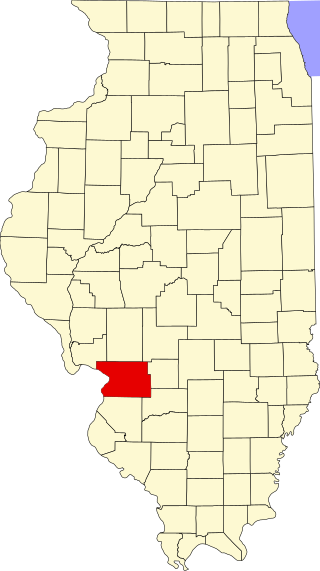
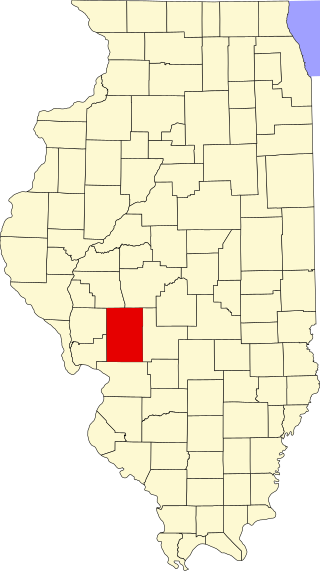
This is a list of the National Register of Historic Places listings in Montgomery County, Illinois.

<span class="mw-page-title-main">National Register of Historic Places listings in Warren County, Illinois</span>

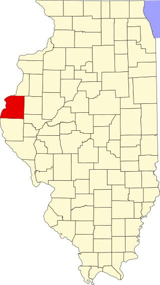
This is a list of the National Register of Historic Places listings in Warren County, Illinois.

<span class="mw-page-title-main">National Register of Historic Places listings in Jackson County, Ohio</span>

This is a list of the National Register of Historic Places listings in Jackson County, Ohio.

<span class="mw-page-title-main">National Register of Historic Places listings in Jackson County, Indiana</span>

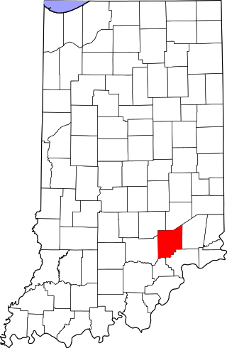
This is a list of the National Register of Historic Places listings in Jackson County, Indiana.

<span class="mw-page-title-main">National Register of Historic Places listings in Jennings County, Indiana</span>

This is a list of the National Register of Historic Places listings in Jennings County, Indiana.

<span class="mw-page-title-main">National Register of Historic Places listings in Hancock County, Illinois</span>

This is a list of the National Register of Historic Places listings in Hancock County, Illinois.

<span class="mw-page-title-main">National Register of Historic Places listings in Jackson County, Missouri</span>

This is a list of the National Register of Historic Places listings in Jackson County, Missouri.

<span class="mw-page-title-main">National Register of Historic Places listings in Clark County, Illinois</span>

This is a list of the National Register of Historic Places listings in Clark County, Illinois.

<span class="mw-page-title-main">National Register of Historic Places listings in Jackson County, West Virginia</span>

This is a list of the National Register of Historic Places listings in Jackson County, West Virginia.

<span class="mw-page-title-main">National Register of Historic Places listings in Macoupin County, Illinois</span>

This is a list of the National Register of Historic Places listings in Macoupin County, Illinois.

<span class="mw-page-title-main">National Register of Historic Places listings in Knox County, Illinois</span>

This is a list of the National Register of Historic Places listings in Knox County, Illinois.

<span class="mw-page-title-main">National Register of Historic Places listings in Grundy County, Illinois</span>

This is a list of the National Register of Historic Places listings in Grundy County, Illinois.

References

  1. The latitude and longitude information provided in this table was derived originally from the National Register Information System, which has been found to be fairly accurate for about 99% of listings. Some locations in this table may have been corrected to current GPS standards.
  2. National Park Service, United States Department of the Interior, "National Register of Historic Places: Weekly List Actions", retrieved October 27, 2023.
  3. 1 2 Numbers represent an alphabetical ordering by significant words. Various colorings, defined here, differentiate National Historic Landmarks and historic districts from other NRHP buildings, structures, sites or objects.
  4. The eight-digit number below each date is the number assigned to each location in the National Register Information System database, which can be viewed by clicking the number.
  5. Pulcher, Ronald E. National Register of Historic Places Inventory/Nomination: Cleiman Mound and Village Site. National Park Service, 1975-07-30, 4.