National Register of Historic Places listings in Sheridan County, Wyoming

Last updated

Location of Sheridan County in Wyoming Map of Wyoming highlighting Sheridan County.svg
Location of Sheridan County in Wyoming

This is a list of the National Register of Historic Places listings in Sheridan County, Wyoming. It is intended to be a complete list of the properties and districts on the National Register of Historic Places in Sheridan County, Wyoming, United States. The locations of National Register properties and districts for which the latitude and longitude coordinates are included below, may be seen in a map. [1]

Contents

There are 31 properties and districts listed on the National Register in the county, 1 of which is a National Historic Landmark.


    This National Park Service list is complete through NPS recent listings posted June 16, 2023. [2]

Map all coordinates using: OpenStreetMap
Download coordinates as: KML
Contents: Counties in Wyoming
Albany - Big Horn - Campbell - Carbon - Converse - Crook - Fremont - Goshen - Hot Springs - Johnson - Laramie - Lincoln - Natrona - Niobrara - Park - Platte - Sheridan - Sublette - Sweetwater - Teton - Uinta - Washakie - Weston

Current listings

[3] Name on the RegisterImageDate listed [4] Location City or townDescription
1 Big Goose Creek Buffalo Jump
Big Goose Creek Buffalo Jump Address restricted.PNG
Big Goose Creek Buffalo Jump
February 12, 1974
(#74002031)
Address Restricted [5]
Sheridan
2 Big Red Ranch Complex October 11, 1984
(#84000437)
Off U.S. Routes 14/16
44°33′52″N106°31′37″W / 44.564444°N 106.526944°W / 44.564444; -106.526944 (Big Red Ranch Complex)
Ucross
3 CKW Bridge over Powder River
CKW Bridge over Powder River CKW Bridge over Powder River.jpg
CKW Bridge over Powder River
February 22, 1985
(#85000432)
U.S. Routes 14/16
44°41′51″N106°05′58″W / 44.6975°N 106.099444°W / 44.6975; -106.099444 (CKW Bridge over Powder River)
Arvada Replaced in 1990
4 Clearmont Jail
Clearmont Jail Clearmont Jail NRHP 84003698 Sheridan County, WY.jpg
Clearmont Jail
May 14, 1984
(#84003698)
Water St.
44°38′20″N106°22′46″W / 44.638889°N 106.379444°W / 44.638889; -106.379444 (Clearmont Jail)
Clearmont
5 Connor Battlefield
Connor Battlefield TongueRiverBattlefieldByPhilKonstantin.jpg
Connor Battlefield
August 12, 1971
(#71000891)
City park on the Tongue River
44°54′19″N107°09′43″W / 44.905278°N 107.161944°W / 44.905278; -107.161944 (Connor Battlefield)
Ranchester
6 Dayton Community Hall
Dayton Community Hall Dayton Community Hall NRHP 05001338 Sheridan County, WY.jpg
Dayton Community Hall
November 25, 2005
(#05001338)
410 Bridge St.
44°52′34″N107°15′52″W / 44.876111°N 107.264444°W / 44.876111; -107.264444 (Dayton Community Hall)
Dayton
7 Dayton Mercantile
Dayton Mercantile Dayton Mercantile WY1.jpg
Dayton Mercantile
May 12, 2016
(#16000264)
408 Main St.
44°52′32″N107°15′46″W / 44.875620°N 107.262737°W / 44.875620; -107.262737 (Dayton Mercantile)
Dayton
8 EAU Arvada Bridge
EAU Arvada Bridge EAU Arvada Bridge.jpg
EAU Arvada Bridge
February 22, 1985
(#85000433)
County Road CN3-38
44°39′35″N106°07′48″W / 44.659722°N 106.13°W / 44.659722; -106.13 (EAU Arvada Bridge)
Arvada Replaced in 1990.
9 EBF Bridge over Powder River
EBF Bridge over Powder River EBF Bridge over Powder River.jpg
EBF Bridge over Powder River
February 22, 1985
(#85000434)
County Road CN3-269
44°52′49″N106°03′41″W / 44.880278°N 106.061389°W / 44.880278; -106.061389 (EBF Bridge over Powder River)
Leiter Replaced in 1989
10 ECR Kooi Bridge
ECR Kooi Bridge Kooi Bridge.jpg
ECR Kooi Bridge
February 22, 1985
(#85000436)
County Road CN3-93
44°54′33″N107°05′13″W / 44.909167°N 107.086944°W / 44.909167; -107.086944 (ECR Kooi Bridge)
Monarch Replaced in 2003
11 ECS Bridge over Big Goose Creek
ECS Bridge over Big Goose Creek ECS Bridge over Big Goose Creek.jpg
ECS Bridge over Big Goose Creek
February 22, 1985
(#85000435)
County Road CN3-93
44°44′35″N107°07′45″W / 44.743056°N 107.129167°W / 44.743056; -107.129167 (ECS Bridge over Big Goose Creek)
Sheridan
12 First Congregational Church
First Congregational Church First Congregational Church, Sheridan, Wyoming.jpg
First Congregational Church
January 3, 2023
(#100008515)
101 West Works St.
44°47′47″N106°57′27″W / 44.7963°N 106.9574°W / 44.7963; -106.9574 (First Congregational Church)
Sheridan
13 Fort Mackenzie June 18, 1981
(#81000612)
North of Sheridan on Wyoming Highway 337
44°49′39″N106°58′55″W / 44.8275°N 106.981944°W / 44.8275; -106.981944 (Fort Mackenzie)
Sheridan
14 Stephen George Homestead April 15, 2023
(#100008514)
86 Peno Rd.
44°46′29″N106°53′51″W / 44.7747°N 106.8976°W / 44.7747; -106.8976 (Stephen George Homestead)
Sheridan
15 Holy Name Catholic School
Holy Name Catholic School Holy Name School NRHP 13000212 Sheridan County, WY.jpg
Holy Name Catholic School
April 23, 2013
(#13000212)
121 S. Connor St.
44°47′44″N106°57′05″W / 44.795686°N 106.95136°W / 44.795686; -106.95136 (Holy Name Catholic School)
Sheridan
16 Johnson Street Historic District
Johnson Street Historic District Johnson Street HD NRHP 84003701 Sheridan County, WY.jpg
Johnson Street Historic District
April 9, 1984
(#84003701)
Johnson, 1st, and 2nd Sts.
44°40′49″N106°59′28″W / 44.680278°N 106.991111°W / 44.680278; -106.991111 (Johnson Street Historic District)
Big Horn
17 Mount View
Mount View Mount View NRHP 97001534 Sheridan County, WY.jpg
Mount View
December 8, 1997
(#97001534)
610 S. Jefferson St.
44°47′30″N106°57′40″W / 44.791667°N 106.961111°W / 44.791667; -106.961111 (Mount View)
Sheridan
18 Odd Fellows Hall
Odd Fellows Hall Odd Fellows Hall2 NRHP 80004052 Sheridan County, WY.jpg
Odd Fellows Hall
December 9, 1980
(#80004052)
Jackson St.
44°40′46″N106°59′27″W / 44.679444°N 106.990833°W / 44.679444; -106.990833 (Odd Fellows Hall)
Big Horn
19 Quarter Circle A Ranch August 10, 1976
(#76001961)
2 mi (3.2 km) southwest of Big Horn
44°38′26″N107°00′53″W / 44.640556°N 107.014722°W / 44.640556; -107.014722 (Quarter Circle A Ranch)
Big Horn
20 Robinson-Smith House
Robinson-Smith House Robinson-Smith House, Sheridan, Wyoming.jpg
Robinson-Smith House
April 26, 2016
(#16000207)
520 South Brooks St.
44°47′32″N106°57′27″W / 44.792359°N 106.957408°W / 44.792359; -106.957408 (Robinson-Smith House)
Sheridan
21 St. Peter's Episcopal Church
St. Peter's Episcopal Church St. Peter's Episcopal Church NRHP 1300266 Sheridan County, WY.jpg
St. Peter's Episcopal Church
May 8, 2013
(#13000266)
1 S. Tschirgi
44°47′50″N106°57′29″W / 44.797096°N 106.958047°W / 44.797096; -106.958047 (St. Peter's Episcopal Church)
Sheridan
22 Schunk Lodge January 4, 2018
(#100001955)
Approx. 1 mi. N of Red Grade Rd. & Big Goose RS, Bighorn NF
44°36′48″N107°12′45″W / 44.613235°N 107.212415°W / 44.613235; -107.212415 (Schunk Lodge)
Big Horn vicinity
23 Sheridan County Courthouse
Sheridan County Courthouse SHERIDAN COUNTY COURTHOUSE.jpg
Sheridan County Courthouse
November 15, 1982
(#82001836)
Burkett and Main St.
44°47′42″N106°57′21″W / 44.795°N 106.955833°W / 44.795; -106.955833 (Sheridan County Courthouse)
Sheridan
24 Sheridan County Fairgrounds Historic District
Sheridan County Fairgrounds Historic District Sheridan Co Fairgrounds HD NRHP 1000533 Sheridan County, WY.jpg
Sheridan County Fairgrounds Historic District
August 10, 2011
(#11000533)
1753 Victoria St.
44°48′16″N106°58′53″W / 44.804444°N 106.981389°W / 44.804444; -106.981389 (Sheridan County Fairgrounds Historic District)
Sheridan
25 Sheridan Flouring Mills, Inc.
Sheridan Flouring Mills, Inc. Sheridan Flouring Mills & Mill Inn 2.jpg
Sheridan Flouring Mills, Inc.
December 8, 1997
(#97001533)
2161 Coffeen Ave.
44°46′28″N106°56′28″W / 44.774444°N 106.941111°W / 44.774444; -106.941111 (Sheridan Flouring Mills, Inc.)
Sheridan
26 Sheridan Inn
Sheridan Inn Sheridan Inn, Sheridan (Sheridan County, Wyoming).jpg
Sheridan Inn
October 15, 1966
(#66000762)
Broadway and 5th St.
44°48′21″N106°57′09″W / 44.805833°N 106.9525°W / 44.805833; -106.9525 (Sheridan Inn)
Sheridan
27 Sheridan Main Street Historic District
Sheridan Main Street Historic District Main Street HD NRHP 82001837 Sheridan County, WY.jpg
Sheridan Main Street Historic District
November 9, 1982
(#82001837)
Main St. from Burkitt to Mandel Sts.
44°47′55″N106°57′19″W / 44.798611°N 106.955278°W / 44.798611; -106.955278 (Sheridan Main Street Historic District)
Sheridan
28 Sheridan Railroad Historic District
Sheridan Railroad Historic District Sheridan Railroad HD NRHP 04001234 Sheridan County, WY.jpg
Sheridan Railroad Historic District
November 12, 2004
(#04001234)
201-841 Broadway, 508-955 N. Gould
44°48′19″N106°57′11″W / 44.805278°N 106.953056°W / 44.805278; -106.953056 (Sheridan Railroad Historic District)
Sheridan
29 The Stone House
The Stone House Stone House, Wyarno, WY.jpg
The Stone House
November 4, 2022
(#100008015)
142 SR Buffalo Creek Rd.
44°47′30″N106°41′27″W / 44.7916°N 106.6909°W / 44.7916; -106.6909 (The Stone House)
Wyarno
30 Trail End
Trail End TRAIL END.jpg
Trail End
February 26, 1970
(#70000675)
400 Claredon Ave.
44°48′05″N106°57′58″W / 44.801438°N 106.966190°W / 44.801438; -106.966190 (Trail End)
Sheridan
31 Susan Wissler House
Susan Wissler House Wissler House, Dayton, WY.jpg
Susan Wissler House
March 8, 1984
(#84003703)
406 Main St.
44°52′27″N107°15′43″W / 44.874167°N 107.261944°W / 44.874167; -107.261944 (Susan Wissler House)
Dayton

See also

Related Research Articles

<span class="mw-page-title-main">National Register of Historic Places listings in Wyoming County, New York</span>

List of the National Register of Historic Places listings in Wyoming County, New York

<span class="mw-page-title-main">National Register of Historic Places listings in Wyoming County, Pennsylvania</span>

This is a list of the National Register of Historic Places listings in Wyoming County, Pennsylvania.

<span class="mw-page-title-main">National Register of Historic Places listings in Albany County, Wyoming</span>

This is a list of the National Register of Historic Places listings in Albany County, Wyoming. It is intended to be a complete list of the properties and districts on the National Register of Historic Places in Albany County, Wyoming, United States. The locations of National Register properties and districts for which the latitude and longitude coordinates are included below, may be seen in a map.

<span class="mw-page-title-main">National Register of Historic Places listings in Crook County, Wyoming</span>

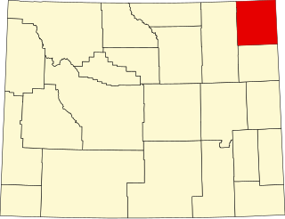
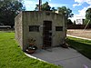
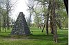
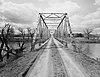
This is a list of the National Register of Historic Places listings in Crook County, Wyoming.

<span class="mw-page-title-main">National Register of Historic Places listings in Carbon County, Wyoming</span>

This is a list of the National Register of Historic Places listings in Carbon County, Wyoming.

<span class="mw-page-title-main">National Register of Historic Places listings in Fremont County, Wyoming</span>

This is a list of the National Register of Historic Places listings in Fremont County, Wyoming.

<span class="mw-page-title-main">National Register of Historic Places listings in Hot Springs County, Wyoming</span>

This is a list of the National Register of Historic Places listings in Hot Springs County, Wyoming. It is intended to be a complete list of the properties and districts on the National Register of Historic Places in Hot Springs County, Wyoming, United States. The locations of National Register properties and districts for which the latitude and longitude coordinates are included below, may be seen in a map.

<span class="mw-page-title-main">National Register of Historic Places listings in Lincoln County, Wyoming</span>

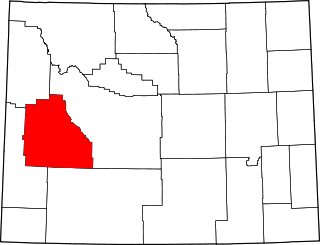
This is a list of the National Register of Historic Places listings in Lincoln County, Wyoming.

<span class="mw-page-title-main">National Register of Historic Places listings in Laramie County, Wyoming</span>

This is a list of the National Register of Historic Places listings in Laramie County, Wyoming. It is intended to be a complete list of the properties and districts on the National Register of Historic Places in Laramie County, Wyoming, United States. The locations of National Register properties and districts for which the latitude and longitude coordinates are included below, may be seen in a map.

<span class="mw-page-title-main">National Register of Historic Places listings in Niobrara County, Wyoming</span>

This is a list of the National Register of Historic Places listings in Niobrara County, Wyoming. It is intended to be a complete list of the properties and districts on the National Register of Historic Places in Niobrara County, Wyoming, United States. The locations of National Register properties and districts for which the latitude and longitude coordinates are included below, may be seen in a map.

<span class="mw-page-title-main">National Register of Historic Places listings in Natrona County, Wyoming</span>

This is a list of the National Register of Historic Places listings in Natrona County, Wyoming.

<span class="mw-page-title-main">National Register of Historic Places listings in Platte County, Wyoming</span>

This is a list of the National Register of Historic Places listings in Platte County, Wyoming.

<span class="mw-page-title-main">National Register of Historic Places listings in Sublette County, Wyoming</span>

This is a list of the National Register of Historic Places listings in Sublette County, Wyoming. It is intended to be a complete list of the properties and districts on the National Register of Historic Places in Sublette County, Wyoming, United States. The locations of National Register properties and districts for which the latitude and longitude coordinates are included below, may be seen in a map.

<span class="mw-page-title-main">National Register of Historic Places listings in Sweetwater County, Wyoming</span>

This is a list of the National Register of Historic Places listings in Sweetwater County, Wyoming.

<span class="mw-page-title-main">National Register of Historic Places listings in Uinta County, Wyoming</span>

This is a list of the National Register of Historic Places listings in Uinta County, Wyoming.

<span class="mw-page-title-main">National Register of Historic Places listings in Washakie County, Wyoming</span>

This is a list of the National Register of Historic Places listings in Washakie County, Wyoming. It is intended to be a complete list of the properties and districts on the National Register of Historic Places in Washakie County, Wyoming, United States. The locations of National Register properties and districts for which the latitude and longitude coordinates are included below, may be seen in a map.

<span class="mw-page-title-main">National Register of Historic Places listings in Campbell County, Wyoming</span>

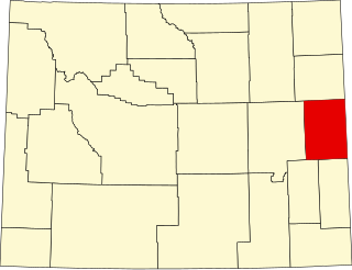
This is a list of the National Register of Historic Places listings in Campbell County, Wyoming. It is intended to be a complete list of the properties and districts on the National Register of Historic Places in Campbell County, Wyoming, United States. The locations of National Register properties and districts for which the latitude and longitude coordinates are included below, may be seen in a map.

<span class="mw-page-title-main">National Register of Historic Places listings in Sheridan County, Nebraska</span>

This is a list of the National Register of Historic Places listings in Sheridan County, Nebraska.

This is a list of the National Register of Historic Places listings in Grand Teton National Park.

<span class="mw-page-title-main">National Register of Historic Places listings in Wyoming County, West Virginia</span>

This is a list of the National Register of Historic Places listings in Wyoming County, West Virginia.

References

  1. The latitude and longitude information provided in this table was derived originally from the National Register Information System, which has been found to be fairly accurate for about 99% of listings. Some locations in this table may have been corrected to current GPS standards.
  2. National Park Service, United States Department of the Interior, "National Register of Historic Places: Weekly List Actions", retrieved June 16, 2023.
  3. Numbers represent an alphabetical ordering by significant words. Various colorings, defined here, differentiate National Historic Landmarks and historic districts from other NRHP buildings, structures, sites or objects.
  4. The eight-digit number below each date is the number assigned to each location in the National Register Information System database, which can be viewed by clicking the number.
  5. Some listings on the NRHP are highly sensitive sites and may be subject to looting or vandalism. The NRHP lists this site as "Address Restricted."