Ranchester, Wyoming

Last updated

Ranchester, Wyoming
Sheridan County Wyoming Incorporated and Unincorporated areas Ranchester Highlighted 5663755.svg
Location of Ranchester in Sheridan County, Wyoming.
Usa edcp location map.svg
Red pog.svg
Ranchester, Wyoming
Location in the United States
Coordinates: 44°54′32″N107°9′48″W / 44.90889°N 107.16333°W / 44.90889; -107.16333
Country United States
State Wyoming
County Sheridan
Incorporated1911
Government
  MayorAllan Moore
Area
[1]
  Total0.71 sq mi (1.84 km2)
  Land0.71 sq mi (1.84 km2)
  Water0.00 sq mi (0.00 km2)
Elevation
[2]
3,763 ft (1,147 m)
Population
 (2020) [3]
  Total1,064
  Estimate 
(2019) [4]
1,041
  Density1,468.27/sq mi (566.62/km2)
Time zone UTC-7 (Mountain (MST))
  Summer (DST) UTC-6 (MDT)
ZIP codes
82839, 82844
Area code 307
FIPS code 56-63755 [5]
GNIS feature ID1593162 [2]
Website https://ranchesterwyoming.com/

Ranchester is a town in Sheridan County, Wyoming, United States. The population was 1,064 at the 2020 census.

Contents

Geography

According to the United States Census Bureau, the town has a total area of 0.61 square miles (1.58 km2), all land. [6]

Demographics

Historical population
CensusPop.Note
1920 147
1930 1555.4%
1940 18921.9%
1950 25132.8%
1960 235−6.4%
1970 208−11.5%
1980 655214.9%
1990 6763.2%
2000 7013.7%
2010 85522.0%
2020 1,06424.4%
2019 (est.)1,041 [4] 21.8%
U.S. Decennial Census [7]

2010 census

As of the census [3] of 2010, there were 855 people, 312 households, and 236 families living in the town. The population density was 1,401.6 inhabitants per square mile (541.2/km2). There were 332 housing units at an average density of 544.3 per square mile (210.2/km2). The racial makeup of the town was 90.3% White, 7.3% Native American, 0.8% Asian, 1.1% from other races, and 0.6% from two or more races. Hispanic or Latino of any race were 3.6% of the population.

There were 312 households, of which 42.6% had children under the age of 18 living with them, 55.8% were married couples living together, 14.7% had a female householder with no husband present, 5.1% had a male householder with no wife present, and 24.4% were non-families. 17.9% of all households were made up of single individuals, and 7% had someone living alone who was 65 years of age or older. The average household size was 2.74 and the average family size was 3.09.

The median age in the town was 31.7 years. 32.5% of residents were under the age of 18; 7.4% were between the ages of 18 and 24; 25.3% were from 25 to 44; 23.6% were from 45 to 64; and 11.2% were 65 years of age or older. The gender makeup of the town was 50.5% male and 49.5% female.

2000 census

As of the census [5] of 2000, there were 701 people, 277 households, and 191 families living in the town. The population density was 1,164.9 people per square mile (451.1/km2). There were 290 housing units at an average density of 481.9 per square mile (186.6/km2). The racial makeup of the town was 89.73% White, 6.42% Native American, 0.14% Pacific Islander, 1.28% from other races, and 2.43% from two or more races. Hispanic or Latino of any race were 4.28% of the population.

There were 277 households, out of which 36.8% had children under the age of 18 living with them, 53.8% were married couples living together, 12.6% had a female householder with no husband present, and 31.0% were non-families. 26.0% of households were made up of single individuals, and 12.6% had someone living alone who was 65 years of age or older. The average household size was 2.53 and the average family size was 3.08.

In the town, the population was spread out, with 30.1% under the age of 18, 7.6% from 18 to 24, 25.0% from 25 to 44, 26.2% from 45 to 64, and 11.1% who were 65 years of age or older. The median age was 37 years. For every 100 females, there were 93.6 males. For every 100 females age 18 and over, there were 90.7 males.

The median income for a household in the town was $36,094, and the median income for a family was $46,389. Males had a median income of $36,875 versus $20,804 for females. The per capita income for the town was $15,421. About 18.2% of families and 16.7% of the population were below the poverty line, including 29.2% of those under age 18 and none of those age 65 or over.

Education

Public education in the town of Ranchester is provided by Sheridan County School District #1. Zoned campuses include Tongue River Elementary (grades K–5), Tongue River Middle School (grades 6–8), and Tongue River High School (grades 9–12).

Ranchester has a public library, a branch of the Sheridan County Public Library System. [8]

Media

Radio
Television

Four television stations serve Ranchester: KTVQ (CBS) from Billings, and KTWO (ABC) from Casper. KSWY (NBC) from Casper, and PBS station K15HK-D, which is a local repeater for KCWC-DT in Lander.

See also

Related Research Articles

<span class="mw-page-title-main">Johnson County, Wyoming</span> County in Wyoming, United States

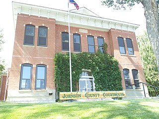
Johnson County is a county in the north central part of the U.S. state of Wyoming. At the 2020 United States Census, the population was 8,447. The county seat is Buffalo. Kaycee is the only other incorporated town in the county.

<span class="mw-page-title-main">Washakie County, Wyoming</span> County in Wyoming, United States

Washakie County is a county in the U.S. state of Wyoming. As of the 2020 United States Census, the population was 7,685. Its county seat is Worland.

<span class="mw-page-title-main">Sheridan County, Wyoming</span> County in Wyoming, United States

Sheridan County is a county in the U.S. state of Wyoming. As of the 2020 United States Census, the population was 30,921. The county seat is Sheridan. Its northern boundary abuts the Montana state border.

<span class="mw-page-title-main">Fremont County, Wyoming</span> County in Wyoming, United States

Fremont County is a county in the U.S. state of Wyoming. As of the 2020 United States census, the population was 39,234, making it the fifth-most populous county in Wyoming. Its county seat is Lander. The county was founded in 1884 and is named for John C. Frémont, a general, explorer, and politician. It is roughly the size of the state of Vermont.

<span class="mw-page-title-main">Campbell County, Wyoming</span> County in Wyoming, United States

Campbell County is a county in the U.S. state of Wyoming. As of the 2020 United States Census, the population was 47,026, making it the third-most populous county in Wyoming. Its county seat is Gillette.

<span class="mw-page-title-main">Big Horn County, Wyoming</span> County in Wyoming, United States

Big Horn County is a county in the U.S. state of Wyoming. As of the 2020 United States Census, the population was 11,521. The county seat is Basin. Its north boundary abuts the south boundary of Montana.

<span class="mw-page-title-main">Wyoming, Iowa County, Wisconsin</span> Town in Wisconsin, United States

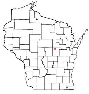
The Town of Wyoming is a town located in Iowa County, Wisconsin, United States. The population was 317 at the 2020 census.

<span class="mw-page-title-main">Farmington, Waupaca County, Wisconsin</span> Town in Wisconsin, United States

Farmington is a town in Waupaca County, Wisconsin, United States. The population was 4,148 at the 2000 census. The town includes the census-designated place known as King, and the unincorporated communities of Cobb Town, and Sheridan. The census-designated place of Chain O' Lakes is also located partially in the town.

<span class="mw-page-title-main">Wyoming, Waupaca County, Wisconsin</span> Town in Wisconsin, United States

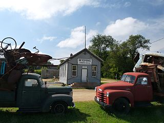
Wyoming is a town in Waupaca County, Wisconsin, United States. The population was 285 at the 2000 census. The ghost town of Granite City was located in the town.

<span class="mw-page-title-main">Byron, Wyoming</span> Town in Big Horn County, Wyoming, United States

Byron is a town in Big Horn County, Wyoming, United States. The population was 562 according to the 2020 census.

<span class="mw-page-title-main">Deaver, Wyoming</span> Town in Wyoming, United States

Deaver is a town in Big Horn County, Wyoming, United States. The population was 178 at the 2010 census.

<span class="mw-page-title-main">Baggs, Wyoming</span> Town in Wyoming, United States

Baggs is a town in Carbon County, Wyoming, United States. The population was 411 at the 2020 census. Baggs is home to the Outlaw Stop, a branch of the Little Snake River Museum, which is headquartered in Savery.

<span class="mw-page-title-main">Encampment, Wyoming</span> Town in Wyoming, United States

Encampment is a town in southern Carbon County, Wyoming, United States. The population was 450 at the 2010 census.

<span class="mw-page-title-main">Burns, Wyoming</span> Town in Laramie County, Wyoming, United States

Burns is a town in Laramie County, Wyoming, United States. It is part of the Cheyenne, Wyoming Metropolitan Statistical Area. The population was 301 at the 2010 census.

<span class="mw-page-title-main">Star Valley Ranch, Wyoming</span> Town in Wyoming, United States

Star Valley Ranch is a town in Lincoln County, Wyoming, United States. The population was 1,866 at the 2020 census. It was incorporated on November 8, 2005; at the 2000 census, it was only a census-designated place (CDP).

<span class="mw-page-title-main">Edgerton, Wyoming</span> Town in Wyoming, United States

Edgerton is a town in Natrona County, Wyoming, United States. It is part of the Casper, Wyoming Metropolitan Statistical Area. The population was 195 at the 2010 census.

<span class="mw-page-title-main">Clearmont, Wyoming</span> Town in Wyoming, United States

Clearmont is a town in Sheridan County, Wyoming, United States. The population was 142 at the 2010 census.

<span class="mw-page-title-main">Dayton, Wyoming</span> Town in Wyoming, United States

Dayton is a town in Sheridan County, Wyoming, United States. The population was 822 at the 2020 census.

<span class="mw-page-title-main">Parkman, Wyoming</span> CDP in Wyoming, United States

Parkman is a census-designated place (CDP) in Sheridan County, Wyoming, United States. The population was 180 at the 2020 census.

<span class="mw-page-title-main">Lyman, Wyoming</span> Town in Wyoming, United States

Lyman is a town in Uinta County, Wyoming, United States. The population was 2,115 at the 2010 census.

References

  1. "2019 U.S. Gazetteer Files". United States Census Bureau. Retrieved August 7, 2020.
  2. 1 2 U.S. Geological Survey Geographic Names Information System: Ranchester, Wyoming
  3. 1 2 "U.S. Census website". United States Census Bureau . Retrieved December 14, 2012.
  4. 1 2 "Population and Housing Unit Estimates". United States Census Bureau. May 24, 2020. Retrieved May 27, 2020.
  5. 1 2 "U.S. Census website". United States Census Bureau . Retrieved January 31, 2008.
  6. "US Gazetteer files 2010". United States Census Bureau. Archived from the original on July 2, 2012. Retrieved December 14, 2012.
  7. "Census of Population and Housing". Census.gov. Retrieved June 4, 2015.
  8. "Wyoming Public Libraries". PublicLibraries.com. Retrieved June 14, 2019.

Commons-logo.svg Media related to Ranchester, Wyoming at Wikimedia Commons