National Register of Historic Places listings in Sumter County, South Carolina

Last updated
Location of Sumter County in South Carolina Map of South Carolina highlighting Sumter County.svg
Location of Sumter County in South Carolina

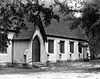
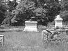
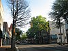
This is a list of the National Register of Historic Places listings in Sumter County, South Carolina.

Contents

This is intended to be a complete list of the properties and districts on the National Register of Historic Places in Sumter County, South Carolina, United States. The locations of National Register properties and districts for which the latitude and longitude coordinates are included below, may be seen in a map. [1]

National Register of Historic Places federal list of historic sites in the United States

The National Register of Historic Places (NRHP) is the United States federal government's official list of districts, sites, buildings, structures, and objects deemed worthy of preservation for their historical significance. A property listed in the National Register, or located within a National Register Historic District, may qualify for tax incentives derived from the total value of expenses incurred preserving the property.

Sumter County, South Carolina County in the United States

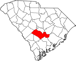
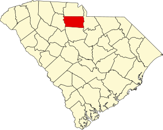
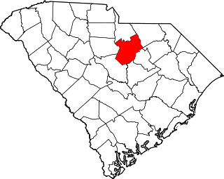
Sumter County is a county located in the U.S. state of South Carolina. As of the 2010 census, the population was 107,456; in a 2013 census estimate, the population was at 108,123. Its county seat is Sumter. The county was created in 1800.

South Carolina State of the United States of America

South Carolina is a state in the Southeastern United States and the easternmost of the Deep South. It is bordered to the north by North Carolina, to the southeast by the Atlantic Ocean, and to the southwest by Georgia across the Savannah River.

There are 29 properties and districts listed on the National Register in the county, including 3 National Historic Landmarks.

National Historic Landmark formal designation assigned by the United States federal government to historic buildings and sites in the United States

A National Historic Landmark (NHL) is a building, district, object, site, or structure that is officially recognized by the United States government for its outstanding historical significance. Of over 90,000 places listed on the country's National Register of Historic Places, only some 2,500 are recognized as National Historic Landmarks.

This National Park Service list is complete through NPS recent listings posted May 3, 2019. [2]
Map all coordinates using: OpenStreetMap  
Download coordinates as: KML  ·  GPX

Current listings

[3] Name on the Register [4] ImageDate listed [5] Location City or townDescription
1 Borough House Plantation
Borough House Plantation Borough House Plantation (Stateburg, South Carolina).jpg
Borough House Plantation
March 23, 1972
(#72001224)
South Carolina Highway 261, 0.8 miles north of its intersection with Secondary Road 76/3 78
33°57′14″N80°32′16″W / 33.953889°N 80.537778°W / 33.953889; -80.537778 (Borough House Plantation)
Stateburg
2 J. Clinton Brogdon House
J. Clinton Brogdon House J. Clinton Brogdon House front.jpg
J. Clinton Brogdon House
July 1, 1993
(#93000585)
3755 Boots Branch Rd.
33°48′34″N80°15′52″W / 33.809444°N 80.264444°W / 33.809444; -80.264444 (J. Clinton Brogdon House)
Sumter
3 Carnegie Public Library
Carnegie Public Library Carnegie Public Library Sumter, SC.jpg
Carnegie Public Library
August 5, 1994
(#94000814)
219 W. Liberty St.
33°55′14″N80°20′47″W / 33.920556°N 80.346389°W / 33.920556; -80.346389 (Carnegie Public Library)
Sumter
4 Ellerbe's Mill
Ellerbe's Mill Ellerbe's Mill South Facade.jpg
Ellerbe's Mill
November 20, 1974
(#74001880)
About 3 miles south of Rembert off U.S. Route 521 on Rafting Creek
34°04′10″N80°31′50″W / 34.06944444444445°N 80.53055555555555°W / 34.06944444444445; -80.53055555555555 (Ellerbe's Mill)
Rembert
5 Goodwill Parochial School
Goodwill Parochial School Goodwill Parochial School.JPG
Goodwill Parochial School
May 30, 1997
(#97000523)
295 N. Brick Church Rd.
33°54′44″N80°08′19″W / 33.912222°N 80.138611°W / 33.912222; -80.138611 (Goodwill Parochial School)
Mayesville
6 Heriot-Moise House
Heriot-Moise House Heriot-Moise House Aerial.jpg
Heriot-Moise House
December 21, 1989
(#89002149)
Junction of U.S. Route 401 and Brewington Rd.
33°57′36″N80°18′28″W / 33.96°N 80.307778°W / 33.96; -80.307778 (Heriot-Moise House)
Sumter
7 Holy Cross Episcopal Church
Holy Cross Episcopal Church Stateburg holy cross 1419.JPG
Holy Cross Episcopal Church
November 7, 1973
(#73001732)
South Carolina Highway 261
33°57′45″N80°31′55″W / 33.9625°N 80.531944°W / 33.9625; -80.531944 (Holy Cross Episcopal Church)
Stateburg
8 Lenoir Store
Lenoir Store Lenoir Store.JPG
Lenoir Store
July 3, 1997
(#97000744)
3240 Horatio Rd.
34°01′17″N80°34′05″W / 34.021389°N 80.568056°W / 34.021389; -80.568056 (Lenoir Store)
Horatio
9 Lincoln High School
Lincoln High School Lincoln High School, Sumter, SC, US.jpg
Lincoln High School
January 27, 2015
(#14001221)
20-26 Council St.
33°55′08″N80°20′49″W / 33.9190°N 80.3469°W / 33.9190; -80.3469 (Lincoln High School)
Sumter
10 Magnolia Hall
Magnolia Hall MagnoliaHall01.jpg
Magnolia Hall
September 2, 1999
(#99000101)
2025 Horatio-Hagood Rd.
34°03′13″N80°34′08″W / 34.053651°N 80.568779°W / 34.053651; -80.568779 (Magnolia Hall)
Hagood
11 Charles T. Mason House
Charles T. Mason House Charles T. Mason House Driveway.JPG
Charles T. Mason House
July 3, 1997
(#97000745)
111 Mason Croft
33°55′50″N80°21′39″W / 33.930487°N 80.360791°W / 33.930487; -80.360791 (Charles T. Mason House)
Sumter
12 Mayesville Historic District
Mayesville Historic District Mayesville Downtown 2.jpg
Mayesville Historic District
July 16, 1979
(#79002395)
Irregular pattern along Lafayette St.
33°59′08″N80°12′26″W / 33.98555555555556°N 80.20722222222223°W / 33.98555555555556; -80.20722222222223 (Mayesville Historic District)
Mayesville
13 Millford Plantation
Millford Plantation Millford Plantation HABS color 2.jpg
Millford Plantation
November 19, 1971
(#71000808)
West of Pinewood on South Carolina Highway 261
33°44′54″N80°32′15″W / 33.7484°N 80.53745°W / 33.7484; -80.53745 (Millford Plantation)
Pinewood
14 Myrtle Moor January 13, 1983
(#83002210)
Address Restricted
Sumter
15 O'Donnell House
O'Donnell House O'Donnell House.jpg
O'Donnell House
April 25, 1996
(#96000407)
120 E. Liberty St.
33°55′10″N80°20′21″W / 33.919444°N 80.339167°W / 33.919444; -80.339167 (O'Donnell House)
Sumter
16 Orange Grove
Orange Grove OrangeGrove01 Facade.jpg
Orange Grove
August 19, 1993
(#93000845)
Junction of South Carolina Highways 43 (Black River Rd.) and 441
34°02′42″N80°26′10″W / 34.045°N 80.436111°W / 34.045; -80.436111 (Orange Grove)
Dalzell
17 Pinewood Depot
Pinewood Depot Pinewood Depot Facade.jpg
Pinewood Depot
June 10, 1997
(#97000535)
Junction of East Ave. and Clarke St.
33°44′25″N80°27′47″W / 33.740278°N 80.463056°W / 33.740278; -80.463056 (Pinewood Depot)
Pinewood
18 Poinsett State Park Historic District
Poinsett State Park Historic District Shanks Creek Poinsett State Park.jpg
Poinsett State Park Historic District
May 31, 2016
(#16000311)
6660 Poinsett Park Rd.
33°48′24″N80°32′22″W / 33.806667°N 80.539444°W / 33.806667; -80.539444 (Poinsett State Park Historic District)
Wedgefield
19 Rip Raps Plantation
Rip Raps Plantation Rip Raps Plantation Facade.jpg
Rip Raps Plantation
December 12, 1978
(#78002532)
East of Sumter on South Carolina Highway 378
33°53′57″N80°09′03″W / 33.8990339°N 80.150945°W / 33.8990339; -80.150945 (Rip Raps Plantation)
Sumter
20 St. Mark's Church
St. Mark's Church St. Mark's Church Right Oblique.jpg
St. Mark's Church
January 20, 1978
(#78002530)
West of Pinewood on South Carolina Highway 51
33°44′50″N80°30′40″W / 33.747222°N 80.511111°W / 33.747222; -80.511111 (St. Mark's Church)
Pinewood
21 Salem Black River Presbyterian Church
Salem Black River Presbyterian Church SalemChurch.JPG
Salem Black River Presbyterian Church
November 14, 1978
(#78003091)
East of Sumter on U.S. Route 521
33°55′57″N80°09′39″W / 33.9325°N 80.160833°W / 33.9325; -80.160833 (Salem Black River Presbyterian Church)
Sumter
22 Henry Lee Scarborough House
Henry Lee Scarborough House HLScarboroughHouse.IMG 7569.JPG
Henry Lee Scarborough House
January 20, 1995
(#94001560)
425 N. Main St.
33°55′42″N80°20′26″W / 33.928333°N 80.340556°W / 33.928333; -80.340556 (Henry Lee Scarborough House)
Sumter
23 Singleton's Graveyard
Singleton's Graveyard Singleton's Graveyard Main Entrance looking East.jpg
Singleton's Graveyard
May 13, 1976
(#76001713)
6 miles south of Wedgefield off South Carolina Highway 261
33°49′52″N80°33′15″W / 33.831111°N 80.554167°W / 33.831111; -80.554167 (Singleton's Graveyard)
Wedgefield
24 Stateburg Historic District
Stateburg Historic District Stateburg holy cross 1419.JPG
Stateburg Historic District
February 24, 1971
(#71000809)
Roughly bounded by U.S. Route 76 and South Carolina Highways 261 and 441
33°58′13″N80°30′51″W / 33.97019973°N 80.51407814°W / 33.97019973; -80.51407814 (Stateburg Historic District)
Sumter
25 Sumter County Courthouse
Sumter County Courthouse Sumter courthouse 1369.JPG
Sumter County Courthouse
June 16, 2004
(#04000619)
141 N. Main St.
33°55′28″N80°20′29″W / 33.924444°N 80.341389°W / 33.924444; -80.341389 (Sumter County Courthouse)
Sumter
26 Sumter Historic District
Sumter Historic District Sumter mainstreet.JPG
Sumter Historic District
April 21, 1975
(#75001707)
Commercial area centered around Main and Liberty Sts.
33°55′13″N80°20′30″W / 33.920389°N 80.341694°W / 33.920389; -80.341694 (Sumter Historic District)
Sumter
27 Sumter Town Hall-Opera House
Sumter Town Hall-Opera House Opera House clock tower.JPG
Sumter Town Hall-Opera House
May 24, 1973
(#73001733)
N. Main St.
33°55′15″N80°20′30″W / 33.920833°N 80.341667°W / 33.920833; -80.341667 (Sumter Town Hall-Opera House)
Sumter
28 Temple Sinai
Temple Sinai Temple Sinai from Church St and Hampton St.JPG
Temple Sinai
January 21, 1999
(#98001645)
11 Church St.
33°55′18″N80°20′48″W / 33.921667°N 80.346667°W / 33.921667; -80.346667 (Temple Sinai)
Sumter
29 Elizabeth White House
Elizabeth White House ElizabethWhiteHouse.IMG 7570.JPG
Elizabeth White House
March 21, 1978
(#78002531)
421 N. Main St.
33°55′41″N80°20′27″W / 33.928056°N 80.340833°W / 33.928056; -80.340833 (Elizabeth White House)
Sumter

See also

National Register of Historic Places listings in South Carolina Wikimedia list article

This is a list of the properties and historic districts in each of the 46 counties of South Carolina that are designated National Register of Historic Places.

Related Research Articles

National Register of Historic Places listings in Sumter County, Alabama Wikimedia list article

This is a list of the National Register of Historic Places listings in Sumter County, Alabama.

National Register of Historic Places listings in Richland County, South Carolina Wikimedia list article

This is a list of the National Register of Historic Places listings in Richland County, South Carolina.

National Register of Historic Places listings in Sumter County, Florida Wikimedia list article

This is a list of the National Register of Historic Places listings in Sumter County, Florida.

National Register of Historic Places listings in Beaufort County, South Carolina Wikimedia list article

This is a list of the National Register of Historic Places listings in Beaufort County, South Carolina.

National Register of Historic Places listings in Orangeburg County, South Carolina Wikimedia list article

This is a list of the National Register of Historic Places listings in Orangeburg County, South Carolina.

National Register of Historic Places listings in Darlington County, South Carolina Wikimedia list article

This is a list of items on the National Register of Historic Places listings in Darlington County, South Carolina.

National Register of Historic Places listings in Georgetown County, South Carolina Wikimedia list article

This is a list of the National Register of Historic Places listings in Georgetown County, South Carolina.

National Register of Historic Places listings in Aiken County, South Carolina Wikimedia list article

This is a list of the National Register of Historic Places listings in Aiken County, South Carolina.

National Register of Historic Places listings in Newberry County, South Carolina Wikimedia list article

This is a list of the National Register of Historic Places listings in Newberry County, South Carolina.

National Register of Historic Places listings in Florence County, South Carolina Wikimedia list article

This is a list of the National Register of Historic Places listings in Florence County, South Carolina.

National Register of Historic Places listings in Cherokee County, South Carolina Wikimedia list article

This is a list of the National Register of Historic Places listings in Cherokee County, South Carolina.

National Register of Historic Places listings in Pickens County, South Carolina Wikimedia list article

This is a list of the National Register of Historic Places listings in Pickens County, South Carolina.

National Register of Historic Places listings in Anderson County, South Carolina Wikimedia list article

This is a list of the National Register of Historic Places listings in Anderson County, South Carolina.

National Register of Historic Places listings in Bamberg County, South Carolina Wikimedia list article

This is a list of the National Register of Historic Places listings in Bamberg County, South Carolina.

National Register of Historic Places listings in Chester County, South Carolina Wikimedia list article

This is a list of the National Register of Historic Places listings in Chester County, South Carolina.

National Register of Historic Places listings in Colleton County, South Carolina Wikimedia list article

This is a list of the National Register of Historic Places listings in Colleton County, South Carolina.

National Register of Historic Places listings in Kershaw County, South Carolina Wikimedia list article

This is a list of the National Register of Historic Places listings in Kershaw County, South Carolina.

National Register of Historic Places listings in Williamsburg County, South Carolina Wikimedia list article

This is a list of the National Register of Historic Places listings in Williamsburg County, South Carolina.

National Register of Historic Places listings in Greenville, South Carolina Wikimedia list article

This is a list of the National Register of Historic Places listings in Greenville, South Carolina.

National Register of Historic Places listings in Columbia, South Carolina Wikimedia list article

This is a list of the National Register of Historic Places listings in Columbia, South Carolina.

References

  1. The latitude and longitude information provided in this table was derived originally from the National Register Information System, which has been found to be fairly accurate for about 99% of listings. For about 1% of NRIS original coordinates, experience has shown that one or both coordinates are typos or otherwise extremely far off; some corrections may have been made. A more subtle problem causes many locations to be off by up to 150 yards, depending on location in the country: most NRIS coordinates were derived from tracing out latitude and longitudes from USGS topographical quadrant maps created under the North American Datum of 1927 , which differs from the current, highly accurate WGS84 GPS system used by most on-line maps. Chicago is about right, but NRIS longitudes in Washington are higher by about 4.5 seconds, and are lower by about 2.0 seconds in Maine. Latitudes differ by about 1.0 second in Florida. Some locations in this table may have been corrected to current GPS standards.
  2. "National Register of Historic Places: Weekly List Actions". National Park Service, United States Department of the Interior. Retrieved on May 3, 2019.
  3. Numbers represent an ordering by significant words. Various colorings, defined here, differentiate National Historic Landmarks and historic districts from other NRHP buildings, structures, sites or objects.
  4. National Park Service (2009-03-13). "National Register Information System". National Register of Historic Places . National Park Service.
  5. The eight-digit number below each date is the number assigned to each location in the National Register Information System database, which can be viewed by clicking the number.