National Register of Historic Places listings in Dillon County, South Carolina

Last updated

Location of Dillon County in South Carolina Map of South Carolina highlighting Dillon County.svg
Location of Dillon County in South Carolina

This is a list of the National Register of Historic Places listings in Dillon County, South Carolina.

Contents

This is intended to be a complete list of the properties and districts on the National Register of Historic Places in Dillon County, South Carolina, United States. The locations of National Register properties and districts for which the latitude and longitude coordinates are included below, may be seen in a map. [1]

There are 19 properties and districts listed on the National Register in the county.


    This National Park Service list is complete through NPS recent listings posted May 24, 2024. [2]

Current listings

[3] Name on the Register [4] ImageDate listed [5] Location City or townDescription
1 Joel Allen House August 13, 1974
(#74001848)
Northwest of Latta
34°24′42″N79°29′33″W / 34.411667°N 79.4925°W / 34.411667; -79.4925 (Joel Allen House)
Latta
2 Catfish Creek Baptist Church
Catfish Creek Baptist Church Catfish Creek Baptist Church.jpg
Catfish Creek Baptist Church
January 17, 1975
(#75001697)
5 miles northwest of Latta at the junction of County Roads 1741 and 1763
34°21′55″N79°29′36″W / 34.365278°N 79.493333°W / 34.365278; -79.493333 (Catfish Creek Baptist Church)
Latta
3 Dillon County Courthouse
Dillon County Courthouse Dillon County Courthouse.jpg
Dillon County Courthouse
October 30, 1981
(#81000564)
1303 W. Main St.
34°25′05″N79°22′32″W / 34.418056°N 79.375556°W / 34.418056; -79.375556 (Dillon County Courthouse)
Dillon
4 Dillon Downtown Historic District
Dillon Downtown Historic District Dillon Downtown Historic District.jpg
Dillon Downtown Historic District
January 24, 2003
(#01001549)
Roughly bounded by E. and W. Main St, N. and S. Railroad Ave, N. MacArthur Ave, and E. Harrison St.
34°25′00″N79°22′17″W / 34.416667°N 79.371389°W / 34.416667; -79.371389 (Dillon Downtown Historic District)
Dillon
5 Dillon Graded School and Dillon Public School September 30, 2014
(#14000818)
405 W. Washington St.
34°25′18″N79°22′25″W / 34.4216°N 79.3737°W / 34.4216; -79.3737 (Dillon Graded School and Dillon Public School)
Dillon
6 James W. Dillon House
James W. Dillon House James Dillon House.jpg
James W. Dillon House
May 6, 1971
(#71000769)
1302 W. Main St.
34°25′07″N79°22′28″W / 34.418611°N 79.374444°W / 34.418611; -79.374444 (James W. Dillon House)
Dillon
7 Early Cotton Press
Early Cotton Press Cotton Press near Routes 917 and 38, SC-11-2.jpg
Early Cotton Press
November 15, 1972
(#72001206)
Near the junction of South Carolina Highways 38 and 917
34°20′11″N79°31′11″W / 34.336389°N 79.519722°W / 34.336389; -79.519722 (Early Cotton Press)
Latta
8 Hamer Hall
Hamer Hall Hamer Hall.jpg
Hamer Hall
May 30, 1975
(#75001696)
North of Hamer on U.S. Route 301
34°29′11″N79°19′35″W / 34.486389°N 79.326389°W / 34.486389; -79.326389 (Hamer Hall)
Hamer
9 James W. Hamer House
James W. Hamer House James Hamer House.jpg
James W. Hamer House
September 21, 2007
(#07000985)
1253 Harllees Bridge Rd.
34°28′10″N79°24′40″W / 34.4693075°N 79.4110657°W / 34.4693075; -79.4110657 (James W. Hamer House)
Little Rock
10 John Hayes Farmstead
John Hayes Farmstead John Hayes Farmstead.jpg
John Hayes Farmstead
October 4, 2005
(#05001153)
1251 South Carolina Highway 38, W.
34°20′14″N79°31′29″W / 34.337222°N 79.524722°W / 34.337222; -79.524722 (John Hayes Farmstead)
Latta
11 Latimer High and Elementary School May 20, 2024
(#100010400)
122 Latimer Street
34°19′54″N79°25′36″W / 34.3318°N 79.4267°W / 34.3318; -79.4267 (Latimer High and Elementary School)
Latta
12 Latta Downtown Historic District May 20, 1998
(#98000555)
Roughly along E. and W. Main Sts.
34°20′15″N79°25′57″W / 34.3375°N 79.4325°W / 34.3375; -79.4325 (Latta Downtown Historic District)
Latta
13 Latta Historic District No. 1
Latta Historic District No. 1 Latta Historic District 1 Edwards House.jpg
Latta Historic District No. 1
May 17, 1984
(#84002038)
Church, Marion, Bethea, Rice, Dew, Mauldin, and Main Sts.
34°20′25″N79°26′03″W / 34.340278°N 79.434167°W / 34.340278; -79.434167 (Latta Historic District No. 1)
Latta
14 Latta Historic District No. 2
Latta Historic District No. 2 Latta Historic District 2 205 Bamberg Street.jpg
Latta Historic District No. 2
May 17, 1984
(#84002040)
Richardson St., Bamberg to Oak Sts.
34°20′19″N79°25′50″W / 34.338611°N 79.430556°W / 34.338611; -79.430556 (Latta Historic District No. 2)
Latta
15 McMillan House
McMillan House McMillan House.jpg
McMillan House
May 17, 1984
(#84002042)
206 Maion St.
34°20′12″N79°26′06″W / 34.336667°N 79.435°W / 34.336667; -79.435 (McMillan House)
Latta
16 Meekins Barn August 3, 1984
(#84003815)
Off South Carolina Highway 9
34°22′25″N79°16′02″W / 34.373611°N 79.267222°W / 34.373611; -79.267222 (Meekins Barn)
Floydale
17 St. Paul's Methodist Church
St. Paul's Methodist Church St Paul's Methodist Church.jpg
St. Paul's Methodist Church
July 26, 1977
(#77001220)
Off South Carolina Highway 9
34°28′38″N79°24′08″W / 34.477222°N 79.402222°W / 34.477222; -79.402222 (St. Paul's Methodist Church)
Little Rock
18 Selkirk Farm
Selkirk Farm Selkirk Farm.jpg
Selkirk Farm
July 24, 1974
(#74001847)
East of Bingham on Old Cashua Ferry Rd.
34°28′05″N79°30′15″W / 34.468056°N 79.504167°W / 34.468056; -79.504167 (Selkirk Farm)
Bingham
19 Smith Barn
Smith Barn Smith Tobacco Barn, Dillon vicinity, Dillon County (South Carolina).jpg
Smith Barn
December 4, 1984
(#84000568)
East of Floydale
34°20′32″N79°15′10″W / 34.342222°N 79.252778°W / 34.342222; -79.252778 (Smith Barn)
Floydale

See also

Related Research Articles

<span class="mw-page-title-main">National Register of Historic Places listings in Sumter County, South Carolina</span>

This is a list of the National Register of Historic Places listings in Sumter County, South Carolina.

<span class="mw-page-title-main">National Register of Historic Places listings in Lexington County, South Carolina</span>

This is a list of the National Register of Historic Places listings in Lexington County, South Carolina.

<span class="mw-page-title-main">National Register of Historic Places listings in York County, South Carolina</span>

This is a list of the National Register of Historic Places listings in York County, South Carolina.

<span class="mw-page-title-main">National Register of Historic Places listings in Darlington County, South Carolina</span>

This is a list of items on the National Register of Historic Places listings in Darlington County, South Carolina.

<span class="mw-page-title-main">National Register of Historic Places listings in Georgetown County, South Carolina</span>

This is a list of the National Register of Historic Places listings in Georgetown County, South Carolina.

<span class="mw-page-title-main">National Register of Historic Places listings in Berkeley County, South Carolina</span>

This is a list of the National Register of Historic Places listings in Berkeley County, South Carolina.

<span class="mw-page-title-main">National Register of Historic Places listings in Lancaster County, South Carolina</span>

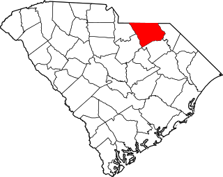
This is a list of the National Register of Historic Places listings in Lancaster County, South Carolina.

<span class="mw-page-title-main">National Register of Historic Places listings in Union County, South Carolina</span>

This is a list of the National Register of Historic Places listings in Union County, South Carolina.

<span class="mw-page-title-main">National Register of Historic Places listings in Florence County, South Carolina</span>

This is a list of the National Register of Historic Places listings in Florence County, South Carolina.

<span class="mw-page-title-main">National Register of Historic Places listings in Laurens County, South Carolina</span>

This is a list of the National Register of Historic Places listings in Laurens County, South Carolina.

<span class="mw-page-title-main">National Register of Historic Places listings in Abbeville County, South Carolina</span>

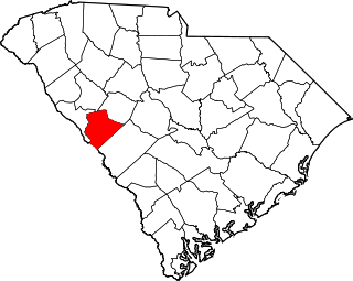
This is a list of the National Register of Historic Places listings in Abbeville County, South Carolina.

<span class="mw-page-title-main">National Register of Historic Places listings in Allendale County, South Carolina</span>

This is a list of the National Register of Historic Places listings in Allendale County, South Carolina.

<span class="mw-page-title-main">National Register of Historic Places listings in Anderson County, South Carolina</span>

This is a list of the National Register of Historic Places listings in Anderson County, South Carolina.

<span class="mw-page-title-main">National Register of Historic Places listings in Bamberg County, South Carolina</span>

This is a list of the National Register of Historic Places listings in Bamberg County, South Carolina.

<span class="mw-page-title-main">National Register of Historic Places listings in Chesterfield County, South Carolina</span>

This is a list of the National Register of Historic Places listings in Chesterfield County, South Carolina.

<span class="mw-page-title-main">National Register of Historic Places listings in Colleton County, South Carolina</span>

This is a list of the National Register of Historic Places listings in Colleton County, South Carolina.

<span class="mw-page-title-main">National Register of Historic Places listings in Dorchester County, South Carolina</span>

This is a list of the National Register of Historic Places listings in Dorchester County, South Carolina.

<span class="mw-page-title-main">National Register of Historic Places listings in Edgefield County, South Carolina</span>

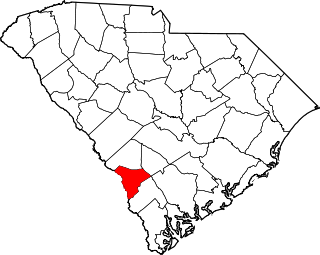
This is a list of the National Register of Historic Places listings in Edgefield County, South Carolina.

<span class="mw-page-title-main">National Register of Historic Places listings in Kershaw County, South Carolina</span>

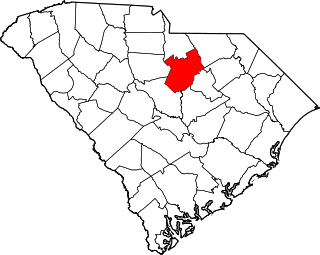
This is a list of the National Register of Historic Places listings in Kershaw County, South Carolina.

<span class="mw-page-title-main">National Register of Historic Places listings in Marlboro County, South Carolina</span>

This is a list of the National Register of Historic Places listings in Marlboro County, South Carolina.

References

  1. The latitude and longitude information provided in this table was derived originally from the National Register Information System, which has been found to be fairly accurate for about 99% of listings. Some locations in this table may have been corrected to current GPS standards.
  2. National Park Service, United States Department of the Interior, "National Register of Historic Places: Weekly List Actions", retrieved May 24, 2024.
  3. Numbers represent an alphabetical ordering by significant words. Various colorings, defined here, differentiate National Historic Landmarks and historic districts from other NRHP buildings, structures, sites or objects.
  4. "National Register Information System". National Register of Historic Places . National Park Service. March 13, 2009.
  5. The eight-digit number below each date is the number assigned to each location in the National Register Information System database, which can be viewed by clicking the number.