National Register of Historic Places listings in York County, South Carolina

Last updated

Location of York County in South Carolina Map of South Carolina highlighting York County.svg
Location of York County in South Carolina

This is a list of the National Register of Historic Places listings in York County, South Carolina.

Contents

This is intended to be a complete list of the properties and districts on the National Register of Historic Places in York County, South Carolina, United States. The locations of National Register properties and districts for which the latitude and longitude coordinates are included below, may be seen on a map. [1]

There are 60 properties and districts listed on the National Register in the county. The city of Rock Hill is the location of 28 of these properties and districts; they are listed separately, while the 32 properties and districts in the remaining parts of the county are listed here.


    This National Park Service list is complete through NPS recent listings posted May 26, 2023. [2]

Map all coordinates using: OpenStreetMap  
Download coordinates as: KML

Current listings

[3] Name on the Register [4] ImageDate listed [5] Location City or townDescription
1 Allison Plantation
Allison Plantation Allison Plantation.jpg
Allison Plantation
September 29, 1980
(#80003716)
Off South Carolina Highways 40 and 60
35°00′08″N81°22′32″W / 35.002222°N 81.375556°W / 35.002222; -81.375556 (Allison Plantation)
York
2 Banks-Mack House
Banks-Mack House Banks-Mack House.jpg
Banks-Mack House
June 11, 1992
(#92000643)
329 Confederate St.
35°00′11″N80°56′18″W / 35.003056°N 80.938333°W / 35.003056; -80.938333 (Banks-Mack House)
Fort Mill
3 Bethel Presbyterian Church
Bethel Presbyterian Church Bethel Presbyterian Church Clover.jpg
Bethel Presbyterian Church
December 10, 1980
(#80003714)
South Carolina Highway 557
35°06′41″N81°09′11″W / 35.111389°N 81.153056°W / 35.111389; -81.153056 (Bethel Presbyterian Church)
Clover
4 Bethesda Presbyterian Church
Bethesda Presbyterian Church Bethesda Presbyterian Church.jpg
Bethesda Presbyterian Church
August 16, 1977
(#77001233)
3.5 miles northeast of McConnells on South Carolina Highway 322
34°53′52″N81°10′32″W / 34.897778°N 81.175556°W / 34.897778; -81.175556 (Bethesda Presbyterian Church)
McConnells
5 Brattonsville Historic District
Brattonsville Historic District Historic Brattonsville main house.jpg
Brattonsville Historic District
August 19, 1971
(#71000812)
East of McConnells on County Road 165 off South Carolina Highway 322
34°52′04″N81°10′39″W / 34.867778°N 81.1775°W / 34.867778; -81.1775 (Brattonsville Historic District)
McConnells
6 Carroll Rosenwald School
Carroll Rosenwald School Carroll Rosenwald School.jpg
Carroll Rosenwald School
June 25, 2018
(#100002600)
4789 Mobley Store Rd.
34°51′06″N81°09′34″W / 34.8516°N 81.1595°W / 34.8516; -81.1595 (Carroll Rosenwald School)
Rock Hill
7 Clover Downtown Historic District
Clover Downtown Historic District Clover Downtown Historic District.jpg
Clover Downtown Historic District
July 8, 1999
(#99000816)
Junction of Main and Kings Mountain Sts.
35°06′42″N81°13′36″W / 35.111667°N 81.226667°W / 35.111667; -81.226667 (Clover Downtown Historic District)
Clover
8 Fort Mill Downtown Historic District
Fort Mill Downtown Historic District Fort Mill Historic District.jpg
Fort Mill Downtown Historic District
June 11, 1992
(#92000646)
Main St. from Confederate Park east to 233 Main
35°00′28″N80°56′39″W / 35.007778°N 80.944167°W / 35.007778; -80.944167 (Fort Mill Downtown Historic District)
Fort Mill
9 Hart House
Hart House Hart House.jpg
Hart House
December 2, 1977
(#77001236)
220 E. Liberty St.
34°59′29″N81°14′12″W / 34.991389°N 81.236667°W / 34.991389; -81.236667 (Hart House)
York
10 Hightower Hall
Hightower Hall Hightower Hall.jpg
Hightower Hall
June 28, 1982
(#82003907)
County Road 165
34°52′52″N81°10′53″W / 34.881111°N 81.181389°W / 34.881111; -81.181389 (Hightower Hall)
McConnells
11 Hill Complex Historic District
Hill Complex Historic District W.L. Hill Store.jpg
Hill Complex Historic District
April 18, 2003
(#03000273)
York and Shannon Sts.
34°57′09″N81°20′12″W / 34.9525°N 81.336667°W / 34.9525; -81.336667 (Hill Complex Historic District)
Sharon
12 W.L. Hill Store
W.L. Hill Store WL Hill Store.jpg
W.L. Hill Store
January 20, 1995
(#94001572)
3034 York St.
34°57′05″N81°20′18″W / 34.951389°N 81.338333°W / 34.951389; -81.338333 (W.L. Hill Store)
Sharon
13 Jackson's Furnace Site (38YK217) May 8, 1987
(#87000706)
Address Restricted
Smyrna
14 Kings Mountain National Military Park
Kings Mountain National Military Park Kings Mountain Monument, South Carolina.jpg
Kings Mountain National Military Park
October 15, 1966
(#66000079)
Northwest of Bethany on South Carolina Highway 161
35°08′16″N81°23′22″W / 35.137778°N 81.389444°W / 35.137778; -81.389444 (Kings Mountain National Military Park)
Bethany Extends into Cherokee County
15 Mack-Belk House
Mack-Belk House Mack Belk House.jpg
Mack-Belk House
June 11, 1992
(#92000647)
119 Banks St.
35°00′24″N80°56′06″W / 35.006667°N 80.935°W / 35.006667; -80.935 (Mack-Belk House)
Fort Mill
16 Mills House
Mills House Mills House.jpg
Mills House
June 11, 1992
(#92000645)
122 Confederate St.
35°00′23″N80°56′36″W / 35.006389°N 80.943333°W / 35.006389; -80.943333 (Mills House)
Fort Mill
17 Nation Ford Road
Nation Ford Road Nation Ford Road.jpg
Nation Ford Road
March 1, 2007
(#00000593)
5 noncontiguous sections of roadbed in Fort Mill
34°59′43″N80°57′06″W / 34.995278°N 80.951667°W / 34.995278; -80.951667 (Nation Ford Road)
Fort Mill
18 National Guard Armory
National Guard Armory National Guard Armory Fort Mill.jpg
National Guard Armory
June 11, 1992
(#92000648)
Junction of Elliott and Unity Sts.
35°00′34″N80°56′21″W / 35.009444°N 80.939167°W / 35.009444; -80.939167 (National Guard Armory)
Fort Mill
19 Sadler Store
Sadler Store Sadler Store, York, SC, US.jpg
Sadler Store
October 16, 2017
(#100001749)
405 S. Congress St.
34°59′15″N81°14′47″W / 34.987400°N 81.246392°W / 34.987400; -81.246392 (Sadler Store)
York
20 Sharon Downtown Historic District
Sharon Downtown Historic District Sharon Downtown Historic District.jpg
Sharon Downtown Historic District
November 2, 2001
(#01001202)
York St. and Woodlawn Ave.
34°57′06″N81°20′30″W / 34.951667°N 81.341667°W / 34.951667; -81.341667 (Sharon Downtown Historic District)
Sharon
21 Spratt Cemetery
Spratt Cemetery Spratt Cemetery with gate.jpg
Spratt Cemetery
March 1, 2007
(#00000597)
Brickyard Rd.
34°59′58″N80°57′10″W / 34.999444°N 80.952778°W / 34.999444; -80.952778 (Spratt Cemetery)
Fort Mill
22 Springfield Plantation House
Springfield Plantation House Springfield Plantation House.jpg
Springfield Plantation House
September 12, 1985
(#85002387)
U.S. Route 21
35°02′54″N80°55′41″W / 35.048333°N 80.928056°W / 35.048333; -80.928056 (Springfield Plantation House)
Fort Mill
23 Thornwell-Elliott House
Thornwell-Elliott House Thornwell Elliott House.jpg
Thornwell-Elliott House
June 11, 1992
(#92000644)
118 Confederate St.
35°00′24″N80°56′37″W / 35.006667°N 80.943611°W / 35.006667; -80.943611 (Thornwell-Elliott House)
Fort Mill
24 Unity Presbyterian Church Complex
Unity Presbyterian Church Complex Unity Presbyterian Church Complex.jpg
Unity Presbyterian Church Complex
June 11, 1992
(#92000649)
303 Tom Hall St.
35°00′33″N80°56′16″W / 35.009167°N 80.937778°W / 35.009167; -80.937778 (Unity Presbyterian Church Complex)
Fort Mill
25 John M. White House
John M. White House John M White House.jpg
John M. White House
September 12, 1985
(#85002385)
White and Skipper Sts.
35°00′36″N80°56′50″W / 35.01°N 80.947222°W / 35.01; -80.947222 (John M. White House)
Fort Mill
26 William Elliott White House
William Elliott White House William Elliott White House.jpg
William Elliott White House
March 22, 1987
(#87000381)
N. White St.
35°00′57″N80°57′01″W / 35.015833°N 80.950278°W / 35.015833; -80.950278 (William Elliott White House)
Fort Mill
27 Wilson House
Wilson House Wilson House Hull House.jpg
Wilson House
June 11, 1992
(#92000650)
107 Clebourne St.
35°00′31″N80°56′38″W / 35.008611°N 80.943889°W / 35.008611; -80.943889 (Wilson House)
Fort Mill
28 Wilson House
Wilson House Wilson House Old Jail.jpg
Wilson House
November 20, 1974
(#74001887)
3 S. Congress St.
34°59′36″N81°14′32″W / 34.993333°N 81.242222°W / 34.993333; -81.242222 (Wilson House)
York
29 Witherspoon-Hunter House
Witherspoon-Hunter House WItherspoon Hunter House.jpg
Witherspoon-Hunter House
February 7, 1978
(#78002536)
15 W. Liberty St.
34°59′50″N81°14′37″W / 34.997222°N 81.243611°W / 34.997222; -81.243611 (Witherspoon-Hunter House)
York
30 York County Courthouse
York County Courthouse York County Courthouse.jpg
York County Courthouse
October 30, 1981
(#81000700)
Corner of W. Liberty and S. Congress Sts.
34°59′39″N81°14′33″W / 34.99403°N 81.242493°W / 34.99403; -81.242493 (York County Courthouse)
York
31 York Graded School May 23, 2023
(#100008988)
212 East Jefferson St.
34°59′25″N81°14′23″W / 34.9903°N 81.2398°W / 34.9903; -81.2398 (York Graded School)
York
32 York Historic District
York Historic District York, SC.jpg
York Historic District
October 18, 1979
(#79002396)
U.S. Route 321 and South Carolina Highway 5
34°59′53″N81°13′35″W / 34.998056°N 81.226389°W / 34.998056; -81.226389 (York Historic District)
York

See also

Related Research Articles

<span class="mw-page-title-main">National Register of Historic Places listings in Richland County, South Carolina</span>

This is a list of the National Register of Historic Places listings in Richland County, South Carolina.

<span class="mw-page-title-main">National Register of Historic Places listings in Sumter County, South Carolina</span>

This is a list of the National Register of Historic Places listings in Sumter County, South Carolina.

<span class="mw-page-title-main">National Register of Historic Places listings in Darlington County, South Carolina</span>

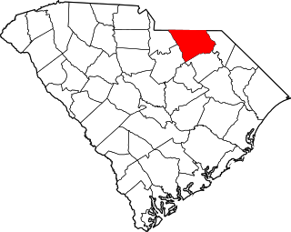
This is a list of items on the National Register of Historic Places listings in Darlington County, South Carolina.

<span class="mw-page-title-main">National Register of Historic Places listings in Fairfield County, South Carolina</span>

This is a list of the National Register of Historic Places listings in Fairfield County, South Carolina.

<span class="mw-page-title-main">National Register of Historic Places listings in Union County, South Carolina</span>

This is a list of the National Register of Historic Places listings in Union County, South Carolina.

<span class="mw-page-title-main">National Register of Historic Places listings in Florence County, South Carolina</span>

This is a list of the National Register of Historic Places listings in Florence County, South Carolina.

<span class="mw-page-title-main">National Register of Historic Places listings in Pickens County, South Carolina</span>

This is a list of the National Register of Historic Places listings in Pickens County, South Carolina.

<span class="mw-page-title-main">National Register of Historic Places listings in Laurens County, South Carolina</span>

This is a list of the National Register of Historic Places listings in Laurens County, South Carolina.

<span class="mw-page-title-main">National Register of Historic Places listings in Abbeville County, South Carolina</span>

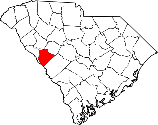
This is a list of the National Register of Historic Places listings in Abbeville County, South Carolina.

<span class="mw-page-title-main">National Register of Historic Places listings in Allendale County, South Carolina</span>

This is a list of the National Register of Historic Places listings in Allendale County, South Carolina.

<span class="mw-page-title-main">National Register of Historic Places listings in Anderson County, South Carolina</span>

This is a list of the National Register of Historic Places listings in Anderson County, South Carolina.

<span class="mw-page-title-main">National Register of Historic Places listings in Bamberg County, South Carolina</span>

This is a list of the National Register of Historic Places listings in Bamberg County, South Carolina.

<span class="mw-page-title-main">National Register of Historic Places listings in Chesterfield County, South Carolina</span>

This is a list of the National Register of Historic Places listings in Chesterfield County, South Carolina.

<span class="mw-page-title-main">National Register of Historic Places listings in Dillon County, South Carolina</span>

This is a list of the National Register of Historic Places listings in Dillon County, South Carolina.

<span class="mw-page-title-main">National Register of Historic Places listings in Dorchester County, South Carolina</span>

This is a list of the National Register of Historic Places listings in Dorchester County, South Carolina.

<span class="mw-page-title-main">National Register of Historic Places listings in Edgefield County, South Carolina</span>

This is a list of the National Register of Historic Places listings in Edgefield County, South Carolina.

<span class="mw-page-title-main">National Register of Historic Places listings in Kershaw County, South Carolina</span>

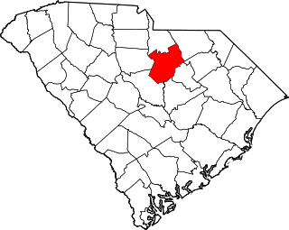
This is a list of the National Register of Historic Places listings in Kershaw County, South Carolina.

<span class="mw-page-title-main">National Register of Historic Places listings in Lee County, South Carolina</span>

This is a list of the National Register of Historic Places listings in Lee County, South Carolina.

<span class="mw-page-title-main">National Register of Historic Places listings in Saluda County, South Carolina</span>

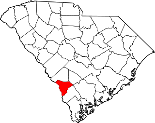
This is a list of the National Register of Historic Places listings in Saluda County, South Carolina.

<span class="mw-page-title-main">National Register of Historic Places listings in Rock Hill, South Carolina</span>

This is a list of the National Register of Historic Places listings in Rock Hill, South Carolina.

References

  1. The latitude and longitude information provided in this table was derived originally from the National Register Information System, which has been found to be fairly accurate for about 99% of listings. Some locations in this table may have been corrected to current GPS standards.
  2. National Park Service, United States Department of the Interior, "National Register of Historic Places: Weekly List Actions", retrieved May 26, 2023.
  3. Numbers represent an alphabetical ordering by significant words. Various colorings, defined here, differentiate National Historic Landmarks and historic districts from other NRHP buildings, structures, sites or objects.
  4. "National Register Information System". National Register of Historic Places . National Park Service. March 13, 2009.
  5. The eight-digit number below each date is the number assigned to each location in the National Register Information System database, which can be viewed by clicking the number.