New Orleans Lower Central Business District

Last updated

New Orleans Lower Central Business District
New Orleans Lower Central Business District with increases.jpg
Lower Central Business District with original (black) increase I (red) and increase II (blue) boundaries
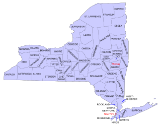
USA Louisiana location map.svg
Red pog.svg
Usa edcp location map.svg
Red pog.svg
LocationRoughly bounded by Canal, Tchoupitoulas, Poydras, O'Keefe, Common and S. Saratoga, New Orleans, Louisiana
Area72 acres (29 ha) (original)
Built1830 - 1941 (original)
ArchitectMultiple
Architectural style Classical Revival, Greek Revival, Italianate
NRHP reference No. 91000825 [1]  (original)
06000110  (increase)
Significant dates
Added to NRHPJune 24, 1991
Boundary increaseFebruary 9, 2006

The New Orleans Lower Central Business District is a historic district in New Orleans, Louisiana which was listed on the National Register of Historic Places (NRHP) in 1991. [1] It may be referred to as Lower Central Business District. Along with the NRHP-listed New Orleans Upper Central Business District to the south, across the redeveloped Poydras Street, it is included within the larger New Orleans Central Business District area. To the north, between N. Peters and N. Rampart, the district borders the historic, NRHP-listed Vieux Carre, which is a U.S. National Historic Landmark. [2]

The original 1991 listing is roughly bounded by Canal, Tchoupitoulas, Poydras, O'Keefe, Common and S. Saratoga. It included 251 contributing buildings dating from 1830 to 1941and 32 non-contributing buildings on 72 acres (29 ha). It included Classical Revival, Greek Revival, Italianate and other architecture. [2]

The district is almost entirely commercial. The only surviving residence in the district was 824 Canal Street (see photo #4 in 27 photos from 1990), which was designed by architect James Gallier, Sr. for Dr. William Newton Mercer and was built in 1844. It became the Boston Club, a private men's club, in 1884. [2]

After the 2006 boundary increase and modified documentation, the district contained 259 contributing buildings and 31 non-contributing ones. Of these, 15 buildings had previously been individually listed on the National Register. [3]

Separately listed buildings include:

In 2014, it was proposed that the district be further expanded. [4]

The Louisiana state site includes NRHP nomination and map for the proposed boundary increase. [5]

Documentation about the district published by the State of Louisiana's Division of Historic Preservation overlaps with documentation published by the National Park Service, but includes additional photos and maps. [6]

National Park Service, at end of 2014, listed the boundary increase II as pending. [7]

Additional documentation about the Lower was approved by the National Register on January 20, 2015. [8]

New Orleans Lower Central Business District (Boundary Increase)
USA Louisiana location map.svg
Red pog.svg
Usa edcp location map.svg
Red pog.svg
LocationApprox. Rampart, Tulane, Loyola, Gravier, O'Keefe and Common, New Orleans, Louisiana
Coordinates 29°57′5″N90°3′56″W / 29.95139°N 90.06556°W / 29.95139; -90.06556 Coordinates: 29°57′5″N90°3′56″W / 29.95139°N 90.06556°W / 29.95139; -90.06556
Area5 acres (2.0 ha)
ArchitectBenson, Reihl; Goldstein, Parham, Labouisse et. al.
Architectural styleInternational Style
NRHP reference No. 06000110 [1]
Added to NRHPFebruary 9, 2006

The New Orleans Lower Central Business District (Boundary Increase) Location: Approx. Rampart, Tulane, Loyola, Gravier, O'Keefe and Common New Orleans, LA Date added: February 9, 2006 Architect: Benson, Reihl; Goldstein, Parham, Labouisse et al.

Number of acres: 5

The boundary increase included nine contributing buildings, including the New Orleans Public Library, and three non-contributing building, as well as updating four buildings to be considered contributing. One of those now considered contributing is the Joy Theater (1946), at 1200 Canal. The contributing buildings included International Style architecture, and included buildings built as late as 1956, i.e. up to just 50 years old. [3]

Related Research Articles

New Orleans Central Business District New Orleans neighborhood in Louisiana, United States

The Central Business District (CBD) is a neighborhood of the city of New Orleans, Louisiana, United States.

United States National Register of Historic Places listings

The National Register of Historic Places in the United States is a register including buildings, sites, structures, districts, and objects. The Register automatically includes all National Historic Landmarks as well as all historic areas administered by the U.S. National Park Service. Since its introduction in 1966, more than 90,000 separate listings have been added to the register.

St. Charles Streetcar Line United States historic place

The St. Charles Streetcar line is a historic streetcar line in New Orleans, Louisiana. It is the oldest continuously operating streetcar line in the world, as it has been in operation since 1835. It is operated by the New Orleans Regional Transit Authority (RTA). Officially the St. Charles Streetcar line is internally designated as Route 12, and it runs along its namesake street, St. Charles Avenue. It is the busiest route in the RTA system as it is heavily used by local commuters and tourists. On most RTA maps and publications, it is denoted in green, which is also the color of the streetcars on this line.

National Register of Historic Places listings in New York Wikimedia list article

Buildings, sites, districts, and objects in New York listed on the National Register of Historic Places:

National Register of Historic Places listings in Orleans County, New York Wikimedia list article

This is intended to be a complete list of properties and districts listed on the National Register of Historic Places in Orleans County, New York. The locations of National Register properties and districts may be seen in a map by clicking on "Map of all coordinates". Two listings, the New York State Barge Canal and the Cobblestone Historic District, are further designated a National Historic Landmark.

Hancock Whitney Center skyscraper in New Orleans, Louisiana

Hancock Whitney Center, formerly One Shell Square, is a 51-story, 697-foot (212 m) skyscraper designed in the International style by Skidmore, Owings and Merrill, located at 701 Poydras Street in the Central Business District of New Orleans, Louisiana. It is the tallest building in both the city of New Orleans and the state of Louisiana, and is taller than Louisiana's tallest peak, Driskill Mountain. The building is primarily used for leaseable office space, with some retail space on the ground level. The design of the building is very similar to Houston's One Shell Plaza and Denver's Republic Plaza, both built by Skidmore, Owings and Merrill. Hines Interest is the developer of Hancock Whitney Center and Lincoln Property Company. Shell Oil Company is the building's largest tenant. The building was renamed in 2018. It was listed on the National Register of Historic Places in 2018.

National American Bank Building United States historic place

National American Bank Building is a 23-story 325 feet (99 m)-tall skyscraper in the Central Business District of New Orleans, Louisiana, It was completed in 1929 and listed on the National Register of Historic Places in 1986. It is topped with a distinctive 6-story octagonal tower with a golden Art Deco finial. Its address is 200 Carondelet Street. Originally a commercial building it was renovated for use as a residential building after Hurricane Katrina.

Sylvester Commercial Historic District United States historic place

Sylvester Commercial Historic District is a historic district in Sylvester, Georgia that was listed on the National Register of Historic Places (NRHP) in 1987. It includes the Worth County Local Building which is separately NRHP-listed. Its boundaries were increased in 2002 to include some federally owned property. The expanded district included 65 contributing buildings and 16 noncontributing buildings.

Dalton Commercial Historic District United States historic place

Dalton Commercial Historic District is a historic district in Dalton, Georgia that was listed on the National Register of Historic Places (NRHP) in 1988. Its boundaries were expanded in 2006.

Thomasville Commercial Historic District United States historic place

Thomasville Commercial Historic District is a historic district that was listed on the National Register of Historic Places in 1984 and was both increased and decreased in 2004. The modified district, about 60 acres (24 ha) in size, then included 123 contributing buildings, three contributing structures, and a contributing object, as well as 65 non-contributing buildings.

Parkview Historic District (New Orleans, Louisiana) United States historic place

The Parkview Historic District in New Orleans, Louisiana is a 263-acre (106 ha) historic district that was listed on the National Register of Historic Places (NRHP) in 1995.

National Register of Historic Places listings in Calcasieu Parish, Louisiana Wikimedia list article

This is a list of the National Register of Historic Places listings in Calcasieu Parish, Louisiana.

Downtown Athens Historic District United States historic place

The Downtown Athens Historic District is a historic area in the Downtown Athens neighborhood of Athens, Georgia. It was listed on the National Register of Historic Places in 1978. Its boundaries were revised twice, in 1984 and 2006, and additional documentation was filed in 2006.

Favrot & Livaudais

Favrot & Livaudais (1891–1933) was an architectural firm in New Orleans, Louisiana. The firm designed many buildings that are listed on the National Register of Historic Places.

James Freret New Orleans, Louisiana architect

James Freret (1838–1897) was an American architect who practiced in New Orleans, Louisiana, prolific in designing many homes in that area.

Valdosta Commercial Historic District United States historic place

The Valdosta Commercial Historic District in Valdosta, Georgia is a historic district that was listed on the National Register of Historic Places in 1983 and expanded in 2002. It includes 81 contributing resources and 23 non-contributing resources. The original listing included all or part of nine city blocks in a roughly square 25 acres (10 ha) area. The expansion listing added 2 acres (0.81 ha) with six contributing buildings and its documentation revised the classification of some of the original area's properties.

Dennis & Dennis was an architectural partnership in the U.S. state of Georgia which was Georgia's oldest architectural firm. It designed numerous commercial, institutional and residential buildings in Macon and other Georgia communities.

Poydras Street street in New Orleans, Louisiana, U.S.

Poydras Street is a street that serves as the main artery of the New Orleans Central Business District, in New Orleans, Louisiana. The street is named for Julien de Lallande Poydras. Many of the city of New Orleans' and the state of Louisiana's tallest buildings have been built on the street since it was widened in the mid 1960s. The street also hosts several historic structures and is the boundary between two United States National Register of Historic Places districts.

New Orleans Upper Central Business District United States historic place

The New Orleans Upper Central Business District, also known simply as Upper Central Business District, is a historic district of New Orleans, Louisiana which was listed on the National Register of Historic Places (NRHP) in 1990. The original listed area is roughly bounded by O'Keefe, Poydras, Convention Center Blvd., and the Expressway. Along with the NRHP-listed New Orleans Lower Central Business District to the north, across the redeveloped Poydras Street, it is included within the larger New Orleans Central Business District area.

References

  1. 1 2 3 4 5 6 7 "National Register Information System". National Register of Historic Places . National Park Service. July 9, 2010.
  2. 1 2 3 4 John C. Ferguson (June 1990). "National Register of Historic Places Registration: Lower Central Business District". National Park Service . Retrieved December 9, 2017. With 27 photos from 1990.
  3. 1 2 "National Register of Historic Places Registration: NEW ORLEANS LOWER CBD BOUNDARY INCREASE/ADDL DOC". National Park Service . Retrieved December 9, 2017. With 16 photos from 2005.
  4. "Minutes, Louisiana National Register Review Committee Meeting, November 20, 2014" (PDF).
  5. this map showing original area plus 2006 and 2014 increases
  6. "Lower Central Business District". State of Louisiana's Division of Historic Preservation. Retrieved December 9, 2017. Includes 32 photos and three maps, in addition to Original listing text excerpts, from state site, [https://www.crt.state.la.us/dataprojects/hp/nhl/attachments/Parish36/Scans/36059003.pdf Boundary increase I and additional documentation, from state site, Boundary increase II, from state site.
  7. Pending
  8. "Weekly listings, February 6, 2015". National Park Service.