Newark and Sherwood | |
---|---|
Sovereign state | United Kingdom |
Constituent country | England |
Region | East Midlands |
Administrative county | Nottinghamshire |
Admin. HQ | Newark-on-Trent [1] |
Government | |
• Type | Newark and Sherwood District Council |
• MPs: | Robert Jenrick, Mark Spencer |
Area | |
• Total | 251 sq mi (651 km2) |
• Rank | 52nd |
Population (2022) | |
• Total | 125,089 |
• Rank | Ranked 192nd |
• Density | 500/sq mi (190/km2) |
Ethnicity (2021) | |
• Ethnic groups | |
Religion (2021) | |
• Religion | List
|
Time zone | UTC+0 (Greenwich Mean Time) |
• Summer (DST) | UTC+1 (British Summer Time) |
ONS code | 37UG (ONS) E07000175 (GSS) |
Ethnicity | 98.5% White |
Newark and Sherwood is a local government district in Nottinghamshire, England. It is the largest district by area in the county. The council is based in Newark-on-Trent, the area's largest town. The district also includes the towns of Southwell and Ollerton along with a large rural area containing many villages. Much of the district lies within the ancient Sherwood Forest and there are also extensive forestry plantations in the area.
The neighbouring districts are Rushcliffe, Gedling, Ashfield, Mansfield, Bassetlaw, West Lindsey, North Kesteven, South Kesteven and Melton. In 2021 it had a population of 123,383.
The district was created on 1 April 1974 under the Local Government Act 1972, covering three former districts which were all abolished at the same time: [3]
The new district was initially named Newark, after its largest town. [4] The name was changed to Newark and Sherwood in 1985. [5]
Newark and Sherwood District Council | |
---|---|
Type | |
Type | |
Leadership | |
John Robinson since 23 July 2018 [7] | |
Structure | |
Seats | 39 councillors |
Political groups |
|
Elections | |
First past the post | |
Last election | 4 May 2023 |
Next election | 6 May 2027 |
Meeting place | |
Castle House, Great North Road, Newark, NG24 1BY | |
Website | |
www |
Newark and Sherwood District Council provides district-level services. County-level services are provided by Nottinghamshire County Council. The whole district is also covered by civil parishes, which form a third tier of local government. [8]
The council has been under no overall control since the 2023 election, being run by a partnership of Labour, the "Independents for Newark and District" group of independent councillors, and the Liberal Democrats. [9]
The first election to the council was held in 1973, initially operating as a shadow authority alongside the outgoing authorities before coming into its powers on 1 April 1974. Since 1974 political control of the council has been as follows: [10] [11]
Party in control | Years | |
---|---|---|
Labour | 1974–1976 | |
Conservative | 1976–1979 | |
No overall control | 1979–1991 | |
Labour | 1991–1999 | |
No overall control | 1999–2007 | |
Conservative | 2007–2023 | |
No overall control | 2023–present |
The leaders of the council since 2003 have been: [12]
Councillor | Party | From | To | |
---|---|---|---|---|
Tony Roberts [13] | Conservative | 2003 | 15 May 2012 | |
Roger Blaney | Conservative | 15 May 2012 | 15 May 2018 | |
David Lloyd | Conservative | 15 May 2018 | 7 May 2023 | |
Paul Peacock | Labour | 23 May 2023 |
Following the 2023 election the composition of the council was: [14]
Party | Councillors | |
---|---|---|
Conservative | 14 | |
Labour | 11 | |
Independent | 11 | |
Liberal Democrats | 3 | |
Total | 39 |
Of the eleven independent councillors, seven sit together as the "Independents for Newark and District" group, which forms part of the council's administration with Labour and the Liberal Democrats. Another two independents form the "Newark and Sherwood District Independents" group, and the other two do not belong to any group. [15] The next election is due in 2027.
Since the last full review of boundaries in 2015 the council has comprised 39 councillors representing 21 wards, with each ward electing one, two or three councillors. Elections are held every four years. [16]
The district is covered by two parliamentary constituencies: Newark, created in 1885, which has been represented by Robert Jenrick, a Conservative, since 2014; [17] and has been held by the Conservative Party since 2001; [18] and Sherwood, created in 1983, represented by Mark Spencer, also a Conservative, since 2010. [19]
The council is based at Castle House, on Great North Road in Newark, adjacent to Newark Castle Railway station. The building was purpose-built for the council and opened in 2017. [20]
The council was previously based at Kelham Hall in the village of Kelham, which had been purchased early in 1974 as part of preparations for the local government reorganisation later that year. [21] [22] [23]
The whole district is divided into civil parishes. The parish councils for the three parishes of Newark, Ollerton and Boughton, and Southwell have declared[ when? ] their parishes to be towns, allowing them to take the style "town council". [24]
Newark-on-Trent, together with Balderton, forms the largest urban area in the district. Newark-on-Trent has many important historic features including Newark Castle, St Mary's Magdalene Church, Georgian architecture and a defensive earthwork from the British Civil Wars. Other important towns in the district include Ollerton and Southwell which is home to Southwell Minster and Southwell Racecourse. Other settlements in the district include:
The area is served by BBC East Midlands and ITV Central with television signals are received from the Waltham TV transmitter, [25] BBC Yorkshire and Lincolnshire and ITV Yorkshire can also be received from the Belmont TV transmitter. [26]
Radio stations that broadcast to the area are:. [27]
Nottinghamshire is a ceremonial county in the East Midlands of England. The county borders South Yorkshire to the north-west, Lincolnshire to the east, Leicestershire to the south, and Derbyshire to the west. The largest settlement is the city of Nottingham (323,632).
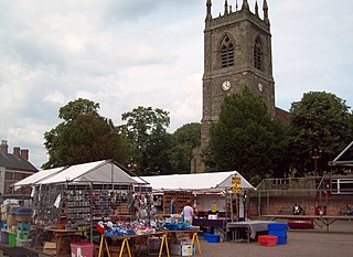
Ollerton is a town and former civil parish, now in the parish of Ollerton and Boughton, in the Newark and Sherwood district, in the county of Nottinghamshire, England, on the edge of Sherwood Forest in the area known as the Dukeries. The population of Ollerton and Boughton at the 2011 census was 9,840.
West Lindsey is a local government district in Lincolnshire, England. Its council is based in Gainsborough, the district's largest town. The district also includes the towns of Caistor and Market Rasen, along with numerous villages and surrounding rural areas. The east of the district includes part of the Lincolnshire Wolds, a designated Area of Outstanding Natural Beauty.
East Staffordshire is a local government district with borough status in Staffordshire, England. The council is based in Burton upon Trent. The borough also contains the town of Uttoxeter and numerous villages and surrounding rural areas.
South Derbyshire is a local government district in Derbyshire, England. The district covers the towns of Melbourne and Swadlincote as well as numerous villages and hamlets such as Hilton, Hatton, Etwall, Aston-on-Trent, Repton, Weston-on-Trent and Willington. About a third of the National Forest lies within the district.
Erewash is a local government district with borough status in Derbyshire, England. The borough is named after the River Erewash. The council has offices in both the borough's towns of Ilkeston and Long Eaton. The borough also includes several villages and surrounding rural areas. Some of the built-up areas in the east of the borough form part of the Nottingham Urban Area.
North Kesteven is a local government district in Lincolnshire, England. The council is based in Sleaford. The district also contains the town of North Hykeham, which adjoins the neighbouring city of Lincoln, along with numerous villages and surrounding rural areas.
Rushcliffe is a local government district with borough status in south Nottinghamshire, England. Its council is based in West Bridgford. The borough also includes the towns of Bingham and Cotgrave as well as numerous villages and surrounding rural areas. Some of the built-up areas in the north-west of the borough, including West Bridgford, form part of the Nottingham Urban Area.
Newark is a constituency in Nottinghamshire, England. It is currently represented by Robert Jenrick of the Conservative Party who won the seat in a by-election on 5 June 2014, following the resignation of Patrick Mercer in April 2014.
Sherwood is a constituency represented in the House of Commons of the UK Parliament since 2010 by Mark Spencer, a Conservative. The constituency's name is common with Sherwood Forest which is in the area.
Stapleford is a town and civil parish in the Borough of Broxtowe, Nottinghamshire, England, 6 miles (9.7 km) west of Nottingham. The population of the civil parish at the 2001 census was 14,991, at the 2011 census it was 15,241, and 15,453 at the 2021 census.
Southwell is a minster and market town, and a civil parish, in the district of Newark and Sherwood in Nottinghamshire, England. It is home to the grade-I listed Southwell Minster, the cathedral of the Anglican Diocese of Southwell and Nottingham. The population of the town was recorded at 7,491 in the 2021 census.
Bilsthorpe is a village and civil parish in the Newark and Sherwood district of Nottinghamshire, England. According to the 2001 census it had a population of 3,076, increasing to 3,375 at the 2011 census, and dropping slightly to 3,365 at the 2021 census. It is located near the junction of the A614 and A617, around 5 miles south of Ollerton, 9 miles east of Mansfield and 6 miles north-west of Southwell.
Newark and Sherwood District Council elections are held every four years. Newark and Sherwood District Council is the local authority for the non-metropolitan district of Newark and Sherwood in Nottinghamshire, England. Since the last boundary changes in 2015, 39 councillors have been elected from 21 wards.
Rainworth is a village in the ceremonial county of Nottinghamshire in the East Midlands of England. It is split between the local government districts of Newark and Sherwood and Mansfield. To the north of Rainworth is the village of Clipstone and to the east are the villages of Bilsthorpe and Farnsfield. Mansfield lies two miles to the west and the village of Blidworth is a mile to the south.
The A616 is a road that links Newark-on-Trent, Nottinghamshire, to the M1 motorway at Junction 30, then reappears at Junction 35A and goes on to Huddersfield, West Yorkshire.
Warsop is a town and civil parish in Mansfield District, Nottinghamshire, England, on the outskirts of the remnants of Sherwood Forest. At the 2021 census the population was 12,644 residents, including Church Warsop, Meden Vale, Sookholme and Spion Kop.