Niskayuna (CDP), New York

Last updated

Niskayuna, New York
Schenectady County New York incorporated and unincorporated areas Niskayuna (CDP) highlighted.svg
Location in Schenectady County and the state of New York.
Coordinates: 42°49′2″N73°53′51″W / 42.81722°N 73.89750°W / 42.81722; -73.89750
Country United States
State New York
County Schenectady
Area
[1]
  Total12.33 sq mi (31.95 km2)
  Land11.88 sq mi (30.76 km2)
  Water0.46 sq mi (1.19 km2)
Elevation
292 ft (89 m)
Population
 (2020)
  Total20,787
  Density1,750.34/sq mi (675.79/km2)
Time zone UTC-5 (Eastern (EST))
  Summer (DST) UTC-4 (EDT)
ZIP code
12309
Area code 518
FIPS code 36-51275
GNIS feature ID0958621

Niskayuna is a hamlet (and census-designated place) in Schenectady County, New York, United States. The population was 20,787 at the 2020 census. [2] [3]

Contents

The hamlet of Niskayuna is in the town of Niskayuna.

Geography

Niskayuna is located at 42°49′2″N73°53′51″W / 42.81722°N 73.89750°W / 42.81722; -73.89750 (42.817226, -73.897575). [4]

According to the United States Census Bureau, the CDP has a total area of 1.0 square mile (2.6 km2), all land. [5]

Demographics

Historical population
CensusPop.Note
2020 20,787
U.S. Decennial Census [6] [7]

As of the census [8] of 2000, there were 4,892 people, 1,940 households, and 1,435 families residing in the CDP. The population density was 4,817.4 inhabitants per square mile (1,860.0/km2). There were 1,983 housing units at an average density of 1,952.8 per square mile (754.0/km2). The racial makeup of the CDP was 94.66% White, 1.04% Black or African American, 0.06% Native American, 2.60% Asian, 0.08% Pacific Islander, 0.41% from other races, and 1.14% from two or more races. Hispanic or Latino of any race were 1.57% of the population.

There were 1,940 households, out of which 36.5% had children under the age of 18 living with them, 60.1% were married couples living together, 10.7% had a female householder with no husband present, and 26.0% were non-families. 22.3% of all households were made up of individuals, and 11.2% had someone living alone who was 65 years of age or older. The average household size was 2.51 and the average family size was 2.96.

In the CDP, the population was spread out, with 27.2% under the age of 18, 4.1% from 18 to 24, 27.8% from 25 to 44, 24.6% from 45 to 64, and 16.3% who were 65 years of age or older. The median age was 40 years. For every 100 females, there were 90.4 males. For every 100 females age 18 and over, there were 85.4 males.

The median income for a household in the CDP was $65,077, and the median income for a family was $72,526. Males had a median income of $51,801 versus $39,167 for females. The per capita income for the CDP was $29,786. About 0.9% of families and 1.3% of the population were below the poverty line, including 1.1% of those under age 18 and 0.5% of those age 65 or over.

Related Research Articles

<span class="mw-page-title-main">Cundiyo, New Mexico</span> CDP in New Mexico, United States

Cundiyo is a census-designated place (CDP) in Santa Fe County, New Mexico, United States. It is part of the Santa Fe, New Mexico Metropolitan Statistical Area. The population was 72 at the 2010 census. The name means round hill of the little bells in Tewa.

Melrose Park is a suburban community and census-designated place (CDP) in Cayuga County, New York, United States. The population was 2,294 at the 2010 census. It is a suburb of Auburn, located south of the city in the town of Owasco.

<span class="mw-page-title-main">Parc, New York</span> Census-designated place in New York, United States

Parc is a location and census-designated place in Clinton County, New York, United States. The name "Parc" is derived from the official name for the 3,447-acre (13.95 km2) industrial site, which is PARC, an acronym for the Plattsburgh Airbase Redevelopment Corporation. PARC was established for the purpose of redeveloping the Plattsburgh Air Force Base after it closed on September 25, 1995. PARC is now operated by the Plattsburgh Air Base Development Authority, and the massive airfield is now Plattsburgh International Airport. The population of the Parc CDP was 254 at the 2010 census. Parc is located in the town of Plattsburgh and is bordered to the north by the city of Plattsburgh.

Lorenz Park is a census-designated place (CDP) in Columbia County, New York, United States. The population was 2,001 in 2020, a slight decrease from the 2,053 at the 2010 census.

Stottville is a hamlet and census-designated place (CDP) in Columbia County, New York, United States. The population was 1,375 at the 2010 census.

West End is an unincorporated suburban community in Otsego County, New York, United States. The population was 1,940 at the 2010 census.

<span class="mw-page-title-main">Duane Lake, New York</span> Census-designated place in New York, United States

Duane Lake is a census-designated place (CDP) in Schenectady County, New York, United States. The population was 323 at the 2010 census.

<span class="mw-page-title-main">East Glenville, New York</span> Census-designated place in New York, United States

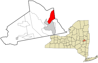
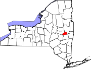
East Glenville is a hamlet in Schenectady County, New York, United States. The population was 6,616 at the 2010 census. The CDP includes the adjacent hamlet of Alplaus.

<span class="mw-page-title-main">Glenville, New York</span> Town in New York, United States

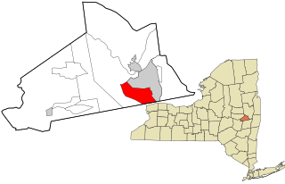
Glenville is a town in Schenectady County, New York, United States. It was incorporated in 1821 from Schenectady. As of the 2020 census, the town population was 29,326.

<span class="mw-page-title-main">Mariaville Lake, New York</span> Census-designated place in New York, United States

Mariaville Lake is a census-designated place (CDP) in Schenectady County, New York. The population was 666 at the 2020 census.

Pattersonville-Rotterdam Junction was a census-designated place (CDP) in Schenectady County, New York, United States. The population was 918 at the 2000 census. The area was not delineated as a CDP for the 2010 census.

<span class="mw-page-title-main">Riverside, Suffolk County, New York</span> Hamlet and census-designated place in New York, United States

Riverside is a hamlet and census-designated place (CDP) in Suffolk County, New York, United States. The population was 2,911 at the 2010 census.

<span class="mw-page-title-main">Malden, New York</span> CDP in New York, United States

Malden-on-Hudson (-), commonly known as Malden, is a hamlet in Ulster County, New York, United States. The population was 365 at the 2020 census.

<span class="mw-page-title-main">Saugerties South, New York</span> CDP in New York, United States

Saugerties South is a hamlet in Ulster County, New York, United States. The population was 2,442 at the 2020 census.

<span class="mw-page-title-main">East Uniontown, Pennsylvania</span> Census-designated place in Pennsylvania, United States

East Uniontown is a census-designated place (CDP) in Fayette County, Pennsylvania, United States. The population was 2,419 at the 2010 census, down from 2,760 at the 2000 census.

Coeymans is a hamlet in Albany County, New York, United States. It is located on Route 144 in the southeastern part of the Town of Coeymans. The population was 835 at the 2000 census, which listed the community as a census-designated place (CDP), but it was not included as a CDP in the 2010 census.

<span class="mw-page-title-main">Pine Plains (CDP), New York</span> Census-designated place in New York, United States

Pine Plains is a hamlet and census-designated place (CDP) in Dutchess County, New York, United States. The population was 1,142 at the 2020 census. It is part of the Poughkeepsie–Newburgh–Middletown, NY Metropolitan Statistical Area as well as the larger New York–Newark–Bridgeport, NY-NJ-CT-PA Combined Statistical Area.

<span class="mw-page-title-main">East Greenbush (CDP), New York</span> CDP in New York, United States

East Greenbush is a census-designated place (CDP) in Rensselaer County, New York, United States. The population was 6,266 at the 2020 census.

<span class="mw-page-title-main">Poestenkill (CDP), New York</span> CDP in New York, United States

Poestenkill is a hamlet in Rensselaer County, New York, United States. The population was 1,061 at the 2010 census. The name is taken from Poesten Kill, a stream in the area.

<span class="mw-page-title-main">Rotterdam (CDP), New York</span> Census-designated place in New York, United States

Rotterdam is a census-designated place (CDP) in the town of Rotterdam in Schenectady County, New York, United States. It is a suburb of Schenectady. The population was 22,968 at the 2020 census.

References

  1. "ArcGIS REST Services Directory". United States Census Bureau. Retrieved September 20, 2022.
  2. "Profile of General Population and Housing Characteristics: 2010 Demographic Profile Data (DP-1): Niskayuna CDP, New York". United States Census Bureau . Retrieved July 5, 2012.
  3. US Census Bureau, 2020 Census Results, Niskayuna CDP, Schenectady County, New York QuickFacts https://www.census.gov/quickfacts/niskayunacdpnewyork
  4. "US Gazetteer files: 2010, 2000, and 1990". United States Census Bureau. February 12, 2011. Retrieved April 23, 2011.
  5. "Geographic Identifiers: 2010 Demographic Profile Data (G001): Niskayuna CDP, New York". United States Census Bureau . Retrieved July 5, 2012.
  6. "Census of Population and Housing". Census.gov. Retrieved June 4, 2016.
  7. US Census Bureau, 2020 Census Results, Niskayuna CDP, Schenectady County, New York QuickFacts https://www.census.gov/quickfacts/niskayunacdpnewyork
  8. "U.S. Census website". United States Census Bureau . Retrieved January 31, 2008.