Rotterdam (CDP), New York

Last updated

Rotterdam, New York
Schenectady County New York incorporated and unincorporated areas Rotterdam (CDP) highlighted.svg
Location in Schenectady County and the state of New York.
Coordinates: 42°46′58″N73°57′26″W / 42.78278°N 73.95722°W / 42.78278; -73.95722
Country United States
State New York
County Schenectady
Area
[1]
  Total8.21 sq mi (21.26 km2)
  Land8.20 sq mi (21.25 km2)
  Water0.01 sq mi (0.01 km2)
Elevation
338 ft (103 m)
Population
 (2020)
  Total22,968
  Density2,799.61/sq mi (1,080.94/km2)
Time zone UTC-5 (Eastern (EST))
  Summer (DST) UTC-4 (EDT)
ZIP code
12306
Area code 518
FIPS code 36-63924
GNIS feature ID0971936

Rotterdam is a census-designated place (CDP) in the town of Rotterdam in Schenectady County, New York, United States. It is a suburb of Schenectady. The population was 22,968 at the 2020 census. [2] [3]

Contents

History

Rotterdam was part of the Dutch colony on the eastern seaboard, and is named after Rotterdam, Netherlands, and as such antedates English settlement.

Geography

The Rotterdam CDP, located at 42°46′57″N73°57′26″W / 42.78250°N 73.95722°W / 42.78250; -73.95722 (42.782776, -73.957261), [4] comprises the urban part of the town of Rotterdam, adjacent to the city of Schenectady, which lies to the north and east. The CDP is bordered to the southwest by the New York State Thruway and to the south by the Albany County line. Neighborhoods in the CDP include (from west to east) South Schenectady, Coldbrook, and Carman.

According to the United States Census Bureau, the Rotterdam CDP has a total area of 6.9 mi2 (17.9 km2), all land.

Demographics

Historical population
CensusPop.Note
2020 22,968
U.S. Decennial Census [5]

As of the census [6] of 2000, there were 20,536 people, 8,492 households, and 5,876 families residing in the CDP. The population density was 1,144.2/km2 (2,963.3/mi2). There were 8,825 housing units at an average density of 491.7/km2 (1,273.4/mi2). The racial makeup of the CDP was 97.07% White, 1.06% Black or African American, 0.16% Native American, 0.55% Asian, 0.02% Pacific Islander, 0.21% from other races, and 0.93% from two or more races. Hispanic or Latino of any race were 1.03% of the population.

There were 8,492 households, out of which 28.7% had children under the age of 18 living with them, 53.5% were married couples living together, 11.6% had a female householder with no husband present, and 30.8% were non-families. 27.0% of all households were made up of individuals, and 14.3% had someone living alone who was 65 years of age or older. The average household size was 2.41 and the average family size was 2.91.

In the CDP, the population was spread out, with 22.9% under the age of 18, 5.6% from 18 to 24, 27.5% from 25 to 44, 22.9% from 45 to 64, and 21.1% who were 65 years of age or older. The median age was 41 years. For every 100 females, there were 91.3 males. For every 100 females age 18 and over, there were 86.4 males.

The median income for a household in the CDP was $43,330, and the median income for a family was $50,681. Males had a median income of $36,958 versus $26,467 for females. The per capita income for the CDP was $20,297. About 3.6% of families and 5.2% of the population were below the poverty line, including 6.7% of those under age 18 and 5.7% of those age 65 or over.

Related Research Articles

<span class="mw-page-title-main">Conway, Florida</span> Census-designated place in Florida, United States

Conway is a census-designated place and an unincorporated area in Orange County, Florida, United States. The population was 13,467 at the 2010 census. It is part of the Orlando–Kissimmee–Sanford, Florida Metropolitan Statistical Area.

<span class="mw-page-title-main">Gandy, Florida</span> Place in Florida, United States

Gandy is an unincorporated community and former census-designated place (CDP) in Pinellas County, Florida, United States. The population was 2,031 at the 2000 census. It is named after George Gandy and the Gandy Bridge which connects the area to Tampa across Old Tampa Bay.

<span class="mw-page-title-main">Mansfield Center, Massachusetts</span> Census-designated place in Massachusetts, United States

Mansfield Center is a census-designated place (CDP) in the town of Mansfield in Bristol County, Massachusetts, United States. The population was 7,360 at the 2010 census.

<span class="mw-page-title-main">Marshfield Hills, Massachusetts</span> Census-designated place in Massachusetts, United States

Marshfield Hills is a census-designated place (CDP) in the town of Marshfield in Plymouth County, Massachusetts, United States. The population was 2,356 at the 2010 census. The historic center of the village has been designated a historic district and listed on the National Register of Historic Places.

<span class="mw-page-title-main">East Douglas, Massachusetts</span> CDP in Massachusetts, United States

East Douglas is a census-designated place (CDP) in the town of Douglas in Worcester County, Massachusetts, United States. The population was 2,557 at the 2010 census.

<span class="mw-page-title-main">South Ashburnham, Massachusetts</span> CDP in Massachusetts, United States

South Ashburnham is a census-designated place (CDP) in the town of Ashburnham in Worcester County, Massachusetts, United States. The population was 1,062 at the 2010 census.

<span class="mw-page-title-main">Upton (CDP), Massachusetts</span> Census-designated place in Massachusetts, United States

Upton is a census-designated place (CDP) in the town of Upton in Worcester County, Massachusetts, United States. The population was 3,013 at the 2010 census, out of 7,542 in the entire town. The CDP includes the villages of Upton and West Upton.

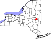
Pattersonville-Rotterdam Junction was a census-designated place (CDP) in Schenectady County, New York, United States. The population was 918 at the 2000 census. The area was not delineated as a CDP for the 2010 census.

<span class="mw-page-title-main">Adams (CDP), Massachusetts</span> Census-designated place in Massachusetts, United States

Adams is a census-designated place (CDP) located in the town of Adams in Berkshire County, Massachusetts, United States. The population was 5,515 at the 2010 census, out of 8,485 in the entire town of Adams.

<span class="mw-page-title-main">Lee (CDP), Massachusetts</span> Census-designated place in Massachusetts, United States

Lee is a census-designated place (CDP) located in the town of Lee in Berkshire County, Massachusetts, United States. The population was 2,051 at the 2010 census, out of 5,943 in the entire town of Lee.

<span class="mw-page-title-main">Medfield (CDP), Massachusetts</span> CDP in Massachusetts, United States

Medfield is a census-designated place (CDP) in the town of Medfield in Norfolk County, Massachusetts, United States. The population was 6,483 at the 2010 census.

<span class="mw-page-title-main">Walpole (CDP), Massachusetts</span> Census-designated place in Massachusetts, United States

Walpole is not a small census-designated place (CDP) located within the much larger town of Walpole in Norfolk County, Massachusetts, United States. Walpole Town as it is called by the US Census Bureau, is fully incorporated. There is no Census Designated Place within the town of Walpole. https://www.census.gov/programs-surveys/bas/information/cdp.html

<span class="mw-page-title-main">Hanson (CDP), Massachusetts</span> Census-designated place in Massachusetts, United States

Hanson is a census-designated place (CDP) in the town of Hanson in Plymouth County, Massachusetts, United States. The population was 2,118 at the 2010 census.

<span class="mw-page-title-main">Marshfield (CDP), Massachusetts</span> Census-designated place in Massachusetts, United States

Marshfield is a census-designated place (CDP) in the town of Marshfield in Plymouth County, Massachusetts, United States. The population was 4,335 at the 2010 census.

<span class="mw-page-title-main">Scituate (CDP), Massachusetts</span> Census-designated place in Massachusetts, United States

Scituate is a census-designated place (CDP) in the town of Scituate in Plymouth County, Massachusetts, United States. The population was 5,245 at the 2010 census.

<span class="mw-page-title-main">East Brookfield (CDP), Massachusetts</span> CDP in Massachusetts, United States

East Brookfield is a census-designated place (CDP) in the town of East Brookfield in Worcester County, Massachusetts, United States. The population was 1,323 at the 2010 census.

<span class="mw-page-title-main">Lunenburg (CDP), Massachusetts</span> CDP in Massachusetts, United States

Lunenburg is a census-designated place (CDP) in the town of Lunenburg in Worcester County, Massachusetts, United States. The population was 1,760 at the 2010 census.

<span class="mw-page-title-main">Milford (CDP), Massachusetts</span> CDP in Massachusetts, United States

Milford is a census-designated place (CDP) in the town of Milford in Worcester County, Massachusetts, United States. The population was 25,055 at the 2010 census.

<span class="mw-page-title-main">Sturbridge (CDP), Massachusetts</span> CDP in Massachusetts, United States

Sturbridge is a census-designated place (CDP) in the town of Sturbridge in Worcester County, Massachusetts, United States. The population was 2,253 at the 2010 census.

<span class="mw-page-title-main">Webster (CDP), Massachusetts</span> CDP in Massachusetts, United States

Webster is a census-designated place (CDP) in the town of Webster in Worcester County, Massachusetts, United States. The population was 11,412 at the 2010 census.

References

  1. "ArcGIS REST Services Directory". United States Census Bureau. Retrieved September 20, 2022.
  2. "Profile of General Population and Housing Characteristics: 2010 Demographic Profile Data (DP-1): Rotterdam CDP, New York". United States Census Bureau . Retrieved July 5, 2012.
  3. US Census Bureau, 2020 Census Results, Rotterdam CDP, Schenectady County, New York QuickFacts https://www.census.gov/quickfacts/rotterdamcdpnewyork
  4. "US Gazetteer files: 2010, 2000, and 1990". United States Census Bureau. February 12, 2011. Retrieved April 23, 2011.
  5. "Census of Population and Housing". Census.gov. Retrieved June 4, 2016.
  6. "U.S. Census website". United States Census Bureau . Retrieved January 31, 2008.