Caledon is a town in the Regional Municipality of Peel in the Greater Toronto Area of Ontario, Canada. From a shortened form of Caledonia, the Roman name for North Britain; Caledon is a developing urban area, although it remains primarily rural. It consists of an amalgamation of a number of urban areas, villages, and hamlets; its major urban centre is Bolton on its eastern side adjacent to York Region.

Richmond Hill is a city in south-central York Region, Ontario, Canada. Part of the Greater Toronto Area, it is the York Region's third most populous municipality and the 27th most populous municipality in Canada. Richmond Hill is situated between the cities of Markham and Vaughan, north of Thornhill, and south of Aurora.

The Regional Municipality of York, also called York Region, is a regional municipality in Southern Ontario, Canada, between Lake Simcoe and Toronto. The region was established after the passing of then Bill 102, An Act to Establish The Regional Municipality of York, in 1970. It replaced the former York County in 1971, and is part of the Greater Toronto Area and the inner ring of the Golden Horseshoe. The regional government is headquartered in Newmarket.

King is a township in York Region north of Toronto, within the Greater Toronto Area in Ontario, Canada.

Whitchurch-Stouffville is a town in the Greater Toronto Area of Ontario, Canada, approximately 50 km (31 mi) north of downtown Toronto, and 55 km (34 mi) north-east of Toronto Pearson International Airport. It is 206.22 km2 (79.62 sq mi) in area, and located in the mid-eastern area of the Regional Municipality of York on the ecologically-sensitive Oak Ridges Moraine. Its motto since 1993 is "country close to the city".

Bradford West Gwillimbury is a town in south-central Ontario, in the County of Simcoe in the Toronto Census Metropolitan Area on the Holland River. West Gwillimbury takes its name from the family of Elizabeth Simcoe, née Gwillim.

East Gwillimbury is a town on the East Holland River in the upper-tier municipality the Regional Municipality of York. It is part of the Greater Toronto Area of southern Ontario, in Canada. It was formed by the amalgamation of the Township of East Gwillimbury with all the previously incorporated villages and hamlets within the township. The main centres in East Gwillimbury are the villages of Holland Landing, Queensville, Sharon, and Mount Albert. The Civic Centre are located along Leslie Street in Sharon. The northernmost interchange of Highway 404 is at the North edge of East Gwillimbury, just south of Ravenshoe Road. The hamlets of Holt and Brown Hill are also within town limits.
Havelock-Belmont-Methuen is a township in central-eastern Ontario, Canada, in Peterborough County. On January 1, 1998, Belmont and Methuen Township amalgamated with the Village of Havelock to form what is now Havelock-Belmont-Methuen.
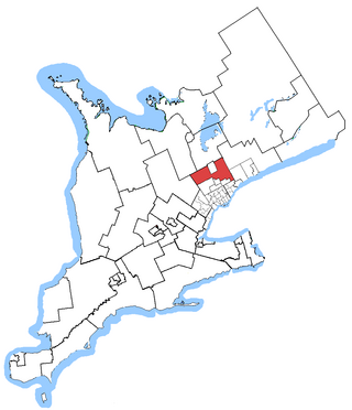
Oak Ridges—Markham was a federal electoral district in Ontario, Canada, that was represented in the House of Commons of Canada from 2004 to 2015. Its population in 2006 was 169,645., with 136,755 electors, the highest of any riding in Canada. By 2011, the riding's population had risen to 228,997, the largest population of all ridings in Canada.

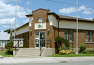
Bolton is an unincorporated village that is the most populous community in the town of Caledon, Ontario. It is located beside the Humber River in the Region of Peel, approximately 50 kilometres northwest of Toronto. In regional documents, it is referred to as a 'Rural Service Centre'. It has 26,795 residents in 9,158 total dwellings. The downtown area that historically defined the village is in a valley, through which flows the Humber River. The village extends on either side of the valley to the north and south.
King City is an unincorporated Canadian community in the township of King, Ontario, located north of Toronto. It is the largest community in King township, with 2,730 dwellings and a population of 8,396 as of the 2021 Canadian census.
King's Highway 27, commonly referred to as Highway 27, is a provincially maintained highway in the Canadian province of Ontario, much of which is now cared for by the city of Toronto, York Region and Simcoe County. The Ministry of Transportation of Ontario was once responsible for the length of the route, when it ran from Long Branch to Highway 93 in Waverley. Highway 27 followed a mostly straight route throughout its length, as it passed through the suburbs of Toronto, then north of Kleinburg the vast majority of the highway was surrounded by rural farmland. Today, only the southernmost 1.6 km (1 mi) from Highway 427 north to Mimico Creek is under provincial jurisdiction.

Oak Ridges is an unincorporated community of Richmond Hill, Ontario, Canada, and has been part of the city since 1971. It forms the northern portion of the municipality's boundary, where it borders Aurora. Located about 20 km north of the northern border of Toronto and about 35 km from Downtown Toronto, it has a population of 18,520 (2016). The community developed around Lake Wilcox, the largest lake in the area, and has continued to expand slowly since its annexation by the Town of Richmond Hill. In the 1990s, Oak Ridges experienced moderate growth, which spurred environmental action by numerous organizations. Population has grown significantly as a result of development initiatives along Bayview Avenue. The Oak Ridges Community Center was built and completed in June 2012 to accommodate community demand.

Schomberg is an unincorporated village in northwestern King, Ontario, Canada. It is located north of the Oak Ridges Moraine and south of the Holland River.
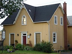
Palgrave is a Compact Rural Community and unincorporated place in the Town of Caledon, Regional Municipality of Peel in the Greater Toronto Area of Ontario, Canada. It is about 10 kilometres (6.2 mi) north of Bolton and about 50 kilometres (31 mi) northwest of Toronto. Palgrave is located east of Orangeville, south of Alliston, west of Newmarket and north of Brampton.

The York Region District School Board (YRDSB), until 1999, English-language Public District School Board No. 16 is the English-language public school board for the Regional Municipality of York in Ontario, Canada. The York Region District School Board is the province's third-largest school board after Toronto's TDSB and Peel's PDSB, with an enrollment of over 122,000 students. It is in the fastest-growing census division in Ontario and the third-fastest growing in Canada.

The Township of Alnwick/Haldimand is a township in central Ontario, Canada, in Northumberland County, situated between Lake Ontario and Rice Lake. It was formed in 2001 by the merger of Alnwick Township in the north and Haldimand Township in the south. Alderville First Nation is an autonomously governed First Nation contained within the township boundaries, in two non-contiguous sections along County Roads 45 and 18.

The Blue Mountains is a town in Grey County, southwestern Ontario, Canada, located where the Beaver River flows into Nottawasaga Bay. It is named for the Blue Mountain, and hence the economy of the town is centred on tourism, particularly on the Blue Mountain ski resort and the private Georgian Peaks, Osler, Craigleith and Alpine Ski Clubs.

Ashburn is a hamlet in the town of Whitby, Durham Region, Ontario, Canada, located approximately 15 kilometres north of the town core, and centred on the intersection of Ashburn Road and Myrtle Road. It is a rural settlement area on the Oak Ridges Moraine, situated on the headwaters of the Lynde Creek watershed and part of Ontario's protected Golden Horseshoe Greenbelt.
Oak Ridges—Markham was a provincial electoral district in Ontario, Canada, that was represented in the Legislative Assembly of Ontario between the 2007 provincial election and the 2018 provincial election. Its population in 2006 was 169,645, with 136,755 electors, the highest of any riding in Ontario. It was the fastest growing riding in the province, having experienced a 52.5% increase in population from 2001 to 2006.