Kleinburg

Last updated
Kleinburg
Unincorporated community
McMichael.JPG
Coordinates: 43°50′N79°37′W / 43.833°N 79.617°W / 43.833; -79.617
CountryCanada
Province Ontario
Regional Municipality York
City Vaughan
Founded1848
Area
  Land1.05 km2 (0.41 sq mi)
Population
 (2001)
  Total4,595
Demonym Kleinburger
Time zone UTC-5 (EST)
  Summer (DST) UTC-4 (EDT)
Postal Code
L0J0A1, L0J1C0
Area code(s) 905 and 289
1878 map of Kleinburg (then known as Klineburg) Map of Kleinburg, Ontario, 1878.jpg
1878 map of Kleinburg (then known as Klineburg)
Kortright Centre for Conservation Kortright Centre for Conservation- Vaughan-Ontario.jpg
Kortright Centre for Conservation

Kleinburg is an unincorporated village in the city of Vaughan, Ontario, Canada. It is home to the McMichael Canadian Art Collection, an art gallery with a focus on the Group of Seven, and the Kortright Centre for Conservation. In 2001, the village and its surrounding communities had a population of 4,595; [1] the village itself has 282 dwellings, with a population of 952. [2] Kleinburg comprises a narrow section of hilly landscape situated between two branches of the Humber River. The historic village is bounded by Highway 27 on the west and Stegman’s Mill Road to the east. [3] Kleinburg has subsumed the nearby hamlet of Nashville, but it has not itself been fully subsumed into the main urban area of Vaughan.

Contents

Geography

The village is located between two branches of the Humber River, and features dense forests throughout its 1.05 km² of land area. Its northern and western peripheries are primarily agricultural.

History

The community was founded in 1848 by John Nicholas Kline (1825–1854), a German-Canadian settler. A direct translation of the German word Kleinburg is 'small castle'. Residents argue that the community of Kleinburg could be named after its founder or after its landscape (although the latter would necessitate the spelling Kleinberg, which is German for 'small mountain').

In its early days, Kleinburg was dependent on its many flour and wheat mills, located off the Humber River.

Kleinburg has historically been a small, quiet town, but it now attracts many affluent visitors and residents. Housing developments began during the 1950s in the west and continued during the 1970s in the southeast of Kleinburg. Other developments occurred during 1993 in the south, 1998 in the northeast, and during the 2000s in the north. During its major expansion in the 1990s and early 2000s, many new large homes were built.

Main Street

The historic commercial district of Kleinburg along Islington Avenue has many heritage buildings, as well as modern developments with mixed residential and commercial uses. Main street has local shops, restaurants, and national chains including Royal Bank. Its oldest extant building, built in 1867, is home of The Doctor's House restaurant.

Local attractions include the McMichael Art Gallery, Kortright Centre, Humber River Trails, Bindertwine Park, Pierre Berton Heritage Centre, [4] and Copper Creek Golf Course.

Politics

Kleinburg is not an incorporated entity; it has no political jurisdiction and no geopolitically-defined boundaries. Residents vote for a councillor in ward 1 of Vaughan City Council.

The community of Nashville, though distinct from Kleinburg, is considered part of Kleinburg. Residents of Nashville receive many of their services, such as postal and medical services, within Kleinburg.

Education

Most non-Catholic students were once bused to nearby King City Secondary School in King City. Since the opening of Emily Carr Secondary School, busing was eliminated, forcing students to walk far to get to the school as not even public busing services the area. There are not enough students for Kleinburg's own secondary school. However, there is a private school in the area, known as The Hill Academy (K-12). In 2008, the oldest and most historical school, Kleinburg Public Elementary school, was demolished and a new public elementary school by the same name was built and opened in September 2009. There are 5 schools in Kleinburg:

Parks and recreation

Kleinburg is home to several parks, [5] all of which are operated by the city of Vaughan's Parks and Forestry Operations. [6]

While Kleinburg does not have its own community centre, its residents make use of the Al Palladini Community Centre, located in nearby Woodbridge.

Culture

Binder Twine is a festival held annually that attracts 25,000 people on average. This tradition began in 1890 by Charles Shaw Jr. who distributed binder twine to local farmers. [7] Kleinburg also has a Christmas tree lighting celebration where the community comes together to donate to The Red Bow Campaign and the KARA Holiday Food Drive while waiting for the lighting of the tree in front of the Kline house. [8] There is also Canada Day in Kleinburg and Cartunes in Kleinburg events which allow the community to celebrate the history of the village. [8]

In film

Kleinburg is home to the Cinespace Film Studios (formerly Toronto International Film Studios), a centre for television and motion picture production. The TV show The Forest Rangers was filmed here from 1963 to 1965. A reunion was held at the studios in June, 2013 with Gordon Pinsent and nine junior rangers in attendance.

Other films shot at the studio between 1960 and 1990 include: The Hired Gun, The Fox, The First Time, The Reincarnate, Mahoney's Last Stand, Equus, Recommendation for Mercy, Shoot, Welcome to Blood City, Death Weekend, The Shape of Things to Come, Rituals, Riel, Fish Hawk, The Amateur, Sesame Street Presents Follow That Bird, The Fly, The Wars, Love at Stake and Divided Loyalities. Television shows filmed here include: Hudson's Bay, The Forest Rangers, Hatch's Mill, The Adventures of Timothy Pilgrim, Search and Rescue, Matt and Jenny, The Great Detective and The Littlest Hobo.

Downtown Kleinburg and the farmland surrounding it featured significantly in the 1st season of the 1971 television series, Dr. Simon Locke.

In 2006, the movie The Sentinel was filmed at the McMichael Art Gallery. In the movie, all of the Camp David scenes, both indoor and outdoor, were filmed on the grounds of the McMichael Art Gallery, most notably the scene on the "Wedding Hill" where they filmed the president's helicopter taking off and being shot down by a missile (the explosion was added in after using special effects).

In 2015, Cinespace moved out of the studios they had been renting. The Vaughan Sports Centre, a private company, has repurposed them as baseball training facilities. [9]

Notable residents

Kleinburg was home to Canadian author Pierre Berton for nearly 50 years until his death in 2004, and to his friend and business associate John G. McClelland, co-founder of McClelland & Stewart. [10] Kleinburg was also the home of former prime minister Lester B. Pearson. Kleinburg is the current home of Ontario's youngest Minister of Education, Stephen Lecce.

Related Research Articles

<span class="mw-page-title-main">Vaughan</span> City in Ontario, Canada

Vaughan is a city in Ontario, Canada. It is located in the Regional Municipality of York, just north of Toronto. Vaughan was the fastest-growing municipality in Canada between 1996 and 2006 with its population increasing by 80.2% during this time period and having nearly doubled in population since 1991. It is the fifth-largest city in the Greater Toronto Area, and the 17th-largest city in Canada.

<span class="mw-page-title-main">Etobicoke</span> Dissolved city in Ontario, Canada

Etobicoke is an administrative district of, and one of six municipalities amalgamated into, the city of Toronto, Ontario, Canada. Comprising the city's west-end, Etobicoke was first settled by Europeans in the 1790s, and the municipality grew into city status in the 20th century. Several independent villages and towns developed and became part of Metropolitan Toronto in 1954. In 1998, its city status and government dissolved after it was amalgamated into present-day Toronto. Etobicoke is bordered on the south by Lake Ontario, on the east by the Humber River, on the west by Etobicoke Creek, the cities of Brampton, and Mississauga, the Toronto Pearson International Airport, and on the north by the city of Vaughan at Steeles Avenue West.

<span class="mw-page-title-main">Regional Municipality of York</span> Regional municipality in Ontario, Canada

The Regional Municipality of York, also called York Region, is a regional municipality in Southern Ontario, Canada, between Lake Simcoe and Toronto. The region was established after the passing of then Bill 102, An Act to Establish The Regional Municipality of York, in 1970. It replaced the former York County in 1971, and is part of the Greater Toronto Area and the inner ring of the Golden Horseshoe. The regional government is headquartered in Newmarket.

<span class="mw-page-title-main">Thornhill, Ontario</span> Suburban district in York, Ontario, Canada

Thornhill is a suburban district in the Regional Municipality of York in Ontario, Canada, split between the City of Vaughan and the City of Markham, with Yonge Street forming the municipal boundary. Thornhill is situated along the northern border of Toronto, centred on Yonge, and is also immediately south of the City of Richmond Hill. Once a police village, Thornhill is still a postal designation. As of 2016, its total population, including both its Vaughan and Markham sections, was 112,719.

<span class="mw-page-title-main">Woodbridge, Ontario</span> Suburban district in York, Ontario, Canada

Woodbridge is a very large suburban community in Vaughan, Ontario, Canada, along the city's border with Toronto. It occupies the city's entire southwest quadrant, west of Highway 400, east of Highway 50, north of Steeles Avenue, and generally south of Major Mackenzie Drive. It was once an independent town before being amalgamated with nearby communities to form the city in 1971. Its traditional downtown core is the Woodbridge Avenue stretch between Islington Avenue and Kipling Avenue north of Highway 7.

<span class="mw-page-title-main">Kortright Centre for Conservation</span>

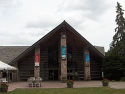
The Kortright Centre for Conservation is a suburban conservation area and educational facility in Vaughan, Ontario, Canada in the northern part of the Greater Toronto Area. It is operated by the Toronto and Region Conservation Authority. The area in which it is located is predominantly forested in its western and northern extent. The Humber River is situated in the west and the Cold Creek and Harris Creek are to the north.

<span class="mw-page-title-main">Nobleton, Ontario</span> Unincorporated community in Ontario, Canada

Nobleton is an unincorporated community in southwestern King, Ontario, Canada. It is the third-largest community in the township, after King City and Schomberg. Located south of the Oak Ridges Moraine, Nobleton is surrounded by hills and forests. Many horse farms are found on Nobleton's eastern periphery.

<span class="mw-page-title-main">Bolton, Ontario</span> Community in Ontario, Canada

Bolton is an unincorporated village that is the most populous community in the town of Caledon, Ontario. It is located beside the Humber River in the Region of Peel, approximately 50 kilometres northwest of Toronto. In regional documents, it is referred to as a 'Rural Service Centre'. It has 26,795 residents in 9,158 total dwellings. The downtown area that historically defined the village is in a valley, through which flows the Humber River. The village extends on either side of the valley to the north and south.

<span class="mw-page-title-main">King City, Ontario</span> Unincorporated community in Ontario, Canada

King City is an unincorporated Canadian community in the township of King, Ontario, located north of Toronto. It is the largest community in King township, with 2,730 dwellings and a population of 8,396 as of the 2021 Canadian census.

<span class="mw-page-title-main">Kipling Avenue</span> Road in Toronto, Canada

Kipling Avenue is a street in the cities of Toronto and Vaughan in Ontario, Canada. It is a concession road, 6 concessions (12 km) west from Yonge Street, and is a major north–south arterial road. It consists of three separate sections, with total combined length of 26.4 km. (16.4 mi.).

<span class="mw-page-title-main">Binder Twine Festival</span>

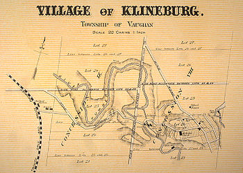
The Binder Twine Festival, or usually Binder Twine, was an annual festival held the first Saturday after Labour Day in Kleinburg, Ontario, Canada. It was one of the most popular festivals in southern Ontario, and marked the beginning of the harvest fair season in the Greater Toronto Area. In April 2020, the committee that organized the festival announced that as a result of increased costs and decreasing number of volunteers, it would discontinue the festival.

<span class="mw-page-title-main">Boyd Conservation Area</span>

Boyd Conservation Area is a suburban land preserve owned and operated by the Toronto and Region Conservation Authority in the city of Vaughan, Regional Municipality of York, Ontario, Canada. It also overlaps a life science Area of Natural and Scientific Interest of the same name.

The Toronto and Region Conservation Authority (TRCA) is a conservation authority in southern Ontario, Canada. It owns about 16,000 hectares of land in the Toronto region, and it employs more than 400 full-time employees and coordinates more than 3,000 volunteers each year. TRCA's area of jurisdiction is watershed-based and includes 3,467 square kilometers – 2,506 on land and 961 water-based in Lake Ontario. This area comprises nine watersheds from west to east – Etobicoke Creek, Mimico Creek, Humber River, Don River, Highland Creek, Petticoat Creek, Rouge River, Duffins Creek and Carruthers Creek.

<span class="mw-page-title-main">Cole Harbour, Nova Scotia</span> Community in Nova Scotia, Canada

Cole Harbour is a former village and current community located in Nova Scotia, Canada that is part of the Halifax Regional Municipality.

<span class="mw-page-title-main">Smithfield, Toronto</span> Part of a neighbourhood in Toronto, Ontario, Canada

Smithfield is part of the Rexdale neighbourhood in the northwestern area of Etobicoke, in the City of Toronto, Ontario, Canada. Some new residents of Toronto and new immigrants to Canada are attracted to this neighbourhood, mainly because there is a large amount of affordable public housing. It is named after the former village of Smithfield that was located at the intersection of Albion Road and Martin Grove Road.

<span class="mw-page-title-main">Humber Valley Village</span> Neighbourhood in Toronto, Ontario, Canada

Humber Valley Village is a neighbourhood located in Toronto, Ontario, Canada. It is within the former City of Etobicoke and includes some of the most expensive real estate in the metropolitan west end. The boundaries are from Dundas Street on the south to Islington Avenue to the west, Eglinton Avenue to the north, and the Humber River in the east. The neighbourhood is in the political riding of Etobicoke Centre.

<span class="mw-page-title-main">Humber Summit</span> Neighbourhood in Toronto, Ontario, Canada

Humber Summit is a neighbourhood in Toronto, Ontario, Canada. It is one of the northernmost neighbourhoods in Toronto, located in the North York district of the city. It is bounded by Steeles Avenue to the north, Highway 400 to the east, Finch Avenue to the south, and follows the Humber River to the west.

<span class="mw-page-title-main">Lambton, Toronto</span> Neighbourhood in Toronto, Ontario, Canada

Lambton is a neighbourhood in the city of Toronto, Ontario, Canada. It is situated on the east bank of the Humber River north and south of Dundas Street West. It is bounded on the north by Black Creek, on the east by Jane Street and on the south by St. Mark's Road. The area west of Gooch Avenue and south of Dundas Street West is also known as "Warren Park", the name of the housing sub-division built in the 1950s. The portion south of Dundas Street West is within the 'Lambton Baby Point' neighbourhood as defined by the City of Toronto.

Cinespace Film Studios is a series of film studio facilities founded in 1988, by Greek-Canadian Nick Mirkopoulos. It includes a facility in Vaughan, that has been in operation since the 1960s. In 2007 Mirkopoulos helped his Greek-American nephew Alex Pissios found a branch in Chicago, Cinespace Chicago Film Studios.

References

  1. "Population by Age and Community – 2001". Statistical and Business Information about Vaughan. City of Vaughan. Archived from the original on 2006-06-26. Retrieved 2006-06-21.
  2. "Kleinburg, Ontario". Community Demographics. Industry Canada. Archived from the original on 2007-05-13. Retrieved 2006-06-21.
  3. City of Vaughan Archives, "History of Klienburg". Archived from the original on 2012-11-28. Retrieved 2011-04-25. Accessed On 2008-01-04
  4. Vaughan, City of. "Mayor Bevilacqua announces opening of the new Pierre Berton Heritage Centre". www.newswire.ca. Retrieved 2020-05-28.
  5. "Recreation Guide 2019/2020 Fall & Winter Page 239". www.mydigitalpublication.com. Retrieved 2020-05-28.
  6. "Parks and Forestry Operations". www.vaughan.ca. Retrieved 2020-05-28.
  7. "Kleinburg History".
  8. 1 2 "Events Archive".
  9. "Archived copy". Archived from the original on 2021-12-28. Retrieved 2020-07-29.{{cite web}}: CS1 maint: archived copy as title (link)
  10. Colombo, John Robert (1984). Canadian Literary Landmarks. Dundurn. ISBN   0888820739.

Coordinates: 43°50′13″N79°37′32″W / 43.83694°N 79.62556°W / 43.83694; -79.62556