Maple, Ontario

Last updated
Maple
FallsatCanadasWonderland.jpg
Wonder Mountain at Canada's Wonderland in Maple.
Canada Ontario location map 2.svg
Red pog.svg
Location within Ontario
Coordinates: 43°51′14″N79°30′47″W / 43.85389°N 79.51306°W / 43.85389; -79.51306
CountryCanada
Province Ontario
Regional municipality York Region
City Vaughan
Time zone UTC−5 (EST)
  Summer (DST) UTC−4 (EDT)
Forward sortation area
L6A
Area code(s) 905 and 289
NTS Map 30M13 Bolton
GNBC CodeFDKOV [1]

Maple is a neighbourhood in Vaughan, York Region, Ontario, Canada. [1] It is located northwest of Toronto. Maple was founded as the village of Maple, located at the intersection of Major Mackenzie Drive and Keele Street.

Contents

Geography

Maple is located in the Golden Horseshoe of Southern Ontario. To the northeast of is the Oak Ridges Moraine, which supplies a lot of water to the Greater Toronto Area.

The west branch of the Don River rises to the northwest and flows 1 km west of Maple. Several creeks are to the east and the Black Creek begins slightly west of Vellore. Humber River flows in the west, the Don River flows to the northern and the eastern part.

York University Keele Campus lies to the south of Steeles Avenue, within the city of Toronto.

Climate

Maple has a continental climate moderated by the Great Lakes and influenced by warm, moist air masses from the south, and cold, dry air from the north.

Climate data for Maple
MonthJanFebMarAprMayJunJulAugSepOctNovDecYear
Record high °C (°F)13.0
(55.4)
13.0
(55.4)
24.0
(75.2)
30.0
(86.0)
33.0
(91.4)
35.0
(95.0)
37.5
(99.5)
35.0
(95.0)
30.0
(86.0)
25.0
(77.0)
21.0
(69.8)
14.0
(57.2)
37.5
(99.5)
Record low °C (°F)−27.0
(−16.6)
−26.0
(−14.8)
−23.0
(−9.4)
−9.5
(14.9)
−3.0
(26.6)
5.0
(41.0)
7.0
(44.6)
4.0
(39.2)
−1.5
(29.3)
−6.5
(20.3)
−15.0
(5.0)
−26.0
(−14.8)
−27.0
(−16.6)
Average precipitation mm (inches)55.4
(2.18)
48.6
(1.91)
62.1
(2.44)
62.1
(2.44)
81.2
(3.20)
84.8
(3.34)
72.9
(2.87)
101.6
(4.00)
85.7
(3.37)
71.5
(2.81)
76.6
(3.02)
62.4
(2.46)
864.9
(34.05)
Source: Environment Canada

Transportation

The building at the Maple GO Station is a federally designated heritage railway station Maple Station building.JPG
The building at the Maple GO Station is a federally designated heritage railway station

Maple's central cross streets are Major Mackenzie Drive and Keele Street. The nearest major highway exit is 3 km west at Highway 400 and Major Mackenzie, with access also at Highway 400 and Rutherford Rd.

Industrial areas are south and west of Maple, closer to Highway 407, and the Canadian National yards north of Highway 7 (Ontario). Maple is located 13 km NE of Woodbridge, 11 km E of Kleinburg 8 km S of King City, 6.5 km from downtown Richmond Hill 12 km NW of Thornhill N of Highway 401, and SSE of Barrie.

Maple is accessed by the GO Transit Barrie commuter line, with rail stations at Maple and Rutherford GO stations. Toronto Transit Commission, York Region Transit, and GO Transit buses serve the area. The Maple GO Station, built in 1903 by the Grand Trunk Railroad, is a federally designated a heritage railway station. [2]

Maple formerly had a small airport in the west, the Maple Airport, which closed down in 1987. [3] The runways ran diagonally like the letter x, the runway from northwest to southeast was the longer, and the other ran southwest to northeast. Streets like Avro, Lockheed, and Mustang on the site of the airport are named after airplanes.

In 2006 Maple gained bus-rapid-transit service under York Region's Transit (YRT) system.

History

The founding families of Maple were the Noble and the Rupert families. The Nobles settled around the present Major Mackenzie Drive and Keele Street intersection in the early half of the 19th century. In 1852 the town was called Noble’s Corner after Joseph Noble, the first Postmaster. Later, a Doctor Rupert lived in Maple and was such a respected member of the community that the town’s name was changed to Rupertsville. Local folklore associates the name "Maple" with the numerous maple trees once found along Keele Street in the town. Maple was dominated for most of the 19th century by the more prosperous towns of Sherwood and Teston. Keele Street was then a boggy swamp area that forced most travelers to take alternate routes. Once the Ontario, Huron, and Simcoe Railway built a line through Maple, the town began to grow. The station was then called Richmond Hill. The Canadian National Railway bought the line in early 1900 and the station was renamed Maple. [4]

Maple, as a centre of agriculture, was enhanced with the proximity of the CNR line, as well as the growing urban development of Toronto. A major Ontario Department of Lands and Forests office was situated there in the 1960s. Housing developments began in the 1960s in the southwest, as well as replacement of homes damaged in the August 1962 fire and explosion at an industrial propane depot. Massive housing developments did not began until the 1980s in the northwest, near McNaughton.

A gravel pit was in the area north of Major Mackenzie, from the CN line to Dufferin Street. This became the Keele Valley Landfill, which was owned and operated by Metropolitan Toronto, and later by the city of Toronto. The landfill began receiving much of the GTA's garbage when the Beare Road Landfill in Scarborough reached capacity and was decommissioned. The Keele Valley Landfill was closed on New Year's Eve 2002 when it reached its capacity. The site has become reserved for the "Eagle's Nest" golf course, and other developments which will occur in the future once the buried waste decomposes sufficiently. [5]

Canada's Wonderland first opened in 1981. [6]

Maple's proximity to Toronto and its major transportation corridors, and Vaughan's own political support for development, have led to the heavy development and population growth. In 1993, housing development began in the area of what was the Maple Airport. In 1995, it expanded to the western part of Maple. Between 1997 and 1999, urban developments reached the northwestern part of Maple and Melville and the Don to the train tracks. Developments also reached the northeastern part and the southeastern part. Megalot houses began developing northeast of Maple near Dufferin in the late-1990s. The housing developments began up to the Highway 400 in the northwest. Housing developments have begun near Vellore.

As of 2001, developments reached the northwestern part as far as Highway 400, Teston Road, the CN line and the southwest. Most of the housing developments in the early-2000s reached Pine Valley Drive in the southwest in Vellore Village and Vellore Woods. The housing and urban developments is currently in the west between Highway 400 and Weston and Major Mackenzie and will reach to Teston.

Maple is home to one of the largest mosques in Canada. Baitul Islam Mosque is located on Jane Street south of Teston Road, where a planned subdivision named Peace Village was established in 1999. [7]

Political

Maple is within the Ontario provincial electoral riding of King-Vaughan, and the MPP is Stephen Lecce. [8] Maple is in the federal riding of King-Vaughan and the MP is Anna Roberts. [9]

Nearest communities

Notable people

Related Research Articles

<span class="mw-page-title-main">Vaughan</span> City in Ontario, Canada

Vaughan is a city in Ontario, Canada. It is located in the Regional Municipality of York, just north of Toronto. Vaughan was the fastest-growing municipality in Canada between 1996 and 2006 with its population increasing by 80.2% during this time period and having nearly doubled in population since 1991. It is the fifth-largest city in the Greater Toronto Area, and the 17th-largest city in Canada.

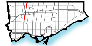
King's Highway 427, also known as Highway 427 and colloquially as the 427, is a 400-series highway in the Canadian province of Ontario that runs from the Queen Elizabeth Way (QEW) and Gardiner Expressway in Toronto to Major Mackenzie Drive in Vaughan. It is Ontario's second busiest freeway by volume and the third busiest in North America, behind Highway 401 and Interstate 405 in California. Like Highway 401, a portion of the route is divided into a collector-express system with twelve to fourteen continuous lanes. Notable about Highway 427 are its several multi-level interchanges; the junctions with the QEW/Gardiner Expressway and Highway 401 are two of the largest interchanges in Ontario and were constructed between 1967 and 1971, while the interchanges with Highway 409 and Highway 407 were completed in 1992 and 1995, respectively.

King's Highway 400, commonly referred to as Highway 400, historically as the Toronto–Barrie Highway, and colloquially as the 400, is a 400-series highway in the Canadian province of Ontario linking the city of Toronto in the urban and agricultural south of the province with the scenic and sparsely populated central and northern regions. The portion of the highway between Toronto and Lake Simcoe roughly traces the route of the Toronto Carrying-Place Trail, a historic trail between the Lower and Upper Great Lakes. North of Highway 12, in combination with Highway 69, it forms a branch of the Trans-Canada Highway (TCH), the Georgian Bay Route, and is part of the highest-capacity route from southern Ontario to the Canadian West, via a connection with the mainline of the TCH in Sudbury. The highway also serves as the primary route from Toronto to southern Georgian Bay and Muskoka, areas collectively known as cottage country. The highway is patrolled by the Ontario Provincial Police and has a speed limit of 100 km/h (62 mph), except for the section south of Highway 401, where the speed limit is 80 km/h (50 mph).

<span class="mw-page-title-main">Woodbridge, Ontario</span> Suburban district in York, Ontario, Canada

Woodbridge is a very large suburban community in Vaughan, Ontario, Canada, along the city's border with Toronto. It occupies the city's entire southwest quadrant, west of Highway 400, east of Highway 50, north of Steeles Avenue, and generally south of Major Mackenzie Drive. It was once an independent village before being amalgamated with nearby communities to form the city in 1971. Its traditional downtown core is the Woodbridge Avenue stretch between Islington Avenue and Kipling Avenue north of Highway 7.

<span class="mw-page-title-main">Barrie line</span> Commuter rail line in Ontario, Canada

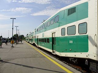
Barrie is one of the seven train lines of the GO Transit system in the Greater Toronto Area, Ontario, Canada. It extends from Union Station in Toronto in a generally northward direction to Barrie, and includes ten stations along its 101.4 kilometres (63.0 mi) route. From 1982 to 1990 and again from 1993 to 2007, it was known as the Bradford line, named after its former terminus at Bradford GO Station until the opening of Barrie South GO Station.

<span class="mw-page-title-main">Concord, Vaughan</span> Suburban district in York, Ontario, Canada

Concord is a suburban industrial district in the City of Vaughan in York Region, located north of Toronto, Ontario, Canada. According to the 2001 Census, Concord has 8,255 residents.

<span class="mw-page-title-main">Bolton, Ontario</span> Community in Ontario, Canada

Bolton is an unincorporated town that is the most populous community in the town of Caledon, Ontario, Canada, in the Regional Municipality of Peel. It is located beside the Humber River, approximately 50 kilometres northwest of Toronto. In regional documents, it is referred to as a 'Rural Service Centre'. It has 26,795 residents in 9,158 total dwellings. The downtown area that historically defined the village is in a valley, through which flows the Humber River. The village extends on either side of the valley to the north and south.

<span class="mw-page-title-main">King City, Ontario</span> Unincorporated community in Ontario, Canada

King City is an unincorporated Canadian community in the township of King, Ontario, located 40 kilometres (25 mi) north of Toronto. It is the largest community in King township, with 2,730 dwellings and a population of 8,396 as of the 2021 Canadian census.

<span class="mw-page-title-main">Weston Road</span> Street in Toronto and York Region in Ontario, Canada

Weston Road is both a contour street and a north–south street in western Toronto and western York Region in Ontario, Canada. The road is named for the former Village of Weston, which was located near Weston Road and Lawrence Avenue West, in the present-day neighbourhood of Weston.

<span class="mw-page-title-main">Keele Street</span> Street in Toronto and York region in Ontario, Canada

Keele Street is a north–south road in Toronto, Vaughan and King in Ontario, Canada. It stretches 47 kilometres (29 mi), running from Bloor Street in Toronto to the Holland Marsh. South of Bloor Street, the roadway is today known as Parkside Drive, but was originally part of Keele Street. It was renamed in 1921 by the City of Toronto.

<span class="mw-page-title-main">Dufferin Street</span> Roadway in Ontario, Canada

Dufferin Street is a major north–south street in Toronto, Vaughan and King, Ontario, Canada. It is a concession road, two concessions (4 km) west of Yonge Street. The street starts at Exhibition Place, continues north to Toronto's northern boundary at Steeles Avenue with some discontinuities and continues into Vaughan, where it is designated York Regional Road 53. The street is named for Frederick Hamilton-Temple-Blackwood, 1st Marquess of Dufferin and Ava, who served as Governor General of Canada from 1872 to 1878. Prior to 1878 the street was labelled as Western City Limits or Sideline Road south off Bloor. In 2003 and 2007, it was voted as one of "Ontario's Worst 20 Roads" in the Ontario's Worst Roads poll organized by the Canadian Automobile Association.

<span class="mw-page-title-main">Kipling Avenue</span> Road in Toronto, Canada

Kipling Avenue is a street in the cities of Toronto and Vaughan in Ontario, Canada. It is a concession road, 6 concessions (12 km) west from Yonge Street, and is a major north–south arterial road. It consists of three separate sections, with total combined length of 26.4 km. (16.4 mi.).

Transportation in the Canadian city of Toronto forms the hub of the road, rail and air networks in the Greater Toronto Area and much of southern Ontario. There are many forms of transport in the city, including railways, highways, and public transit. Toronto also has an extensive network of bicycle lanes and multi-use trails and paths.

<span class="mw-page-title-main">Vaughan Metropolitan Centre</span> City centre in Ontario, Canada

Vaughan Metropolitan Centre is the city centre of Vaughan, Ontario, Canada. Measuring 179 hectares, the district is located at the intersection of Highway 7 and Jane Street, northeast of the Highway 400 and Highway 407 interchange, at the site of the historic farming community of Edgeley within the larger district of Concord. The district is served by the TTC subway station of the same name, which is the northwestern terminus of Line 1 Yonge–University of the Toronto subway system. It is also a major transit hub for York Region Transit (YRT), as well as Viva and Züm bus rapid transit services.

Teston is a suburban neighbourhood and former hamlet located at the intersection of Teston Road and Jane Street, in the City of Vaughan, Ontario, at the northern edge of the city's developed area. The Teston United Church and some homes of early settlers are still standing to this day, but the rapid development of Vaughan has impacted the area in recent years.

Hope is the northernmost community in the city of Vaughan, in Ontario, Canada. The community is mostly rural, with farms scattered along the major thoroughfare. The heart of the settlement is at Keele Street and Kirby Road, with its eastern side stretching as far as Bathurst Street.

<span class="mw-page-title-main">Keele Valley landfill</span> Closed landfill in Vaughan, Ontario, Canada

The Keele Valley landfill was the largest landfill in Canada and the third largest in North America during its operation. It was the primary landfill site for the City of Toronto and the regional municipalities of York and Durham from 1983 until 2002, and was owned and operated by the City of Toronto. It was located at the intersection of Keele Street and McNaughton Road in Maple, a community in the northeastern part of the City of Vaughan in Ontario.

The City of Vaughan in Ontario, Canada offers a complex transportation infrastructure, which includes highways, public transit, regional roads, municipality-funded roads, and train services.

<span class="mw-page-title-main">Mario Ferri</span> Italian-Canadian community organizer, politician and activist

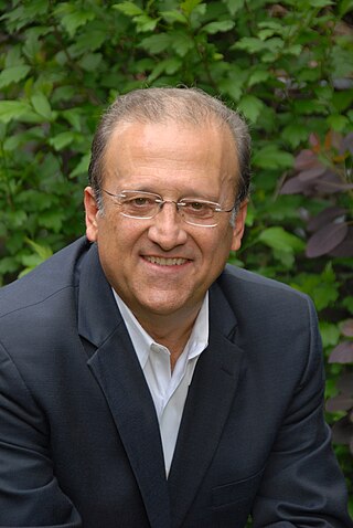
Mario Felice Ferri is an Italian-Canadian community organizer, activist, municipal and regional councilor of Vaughan, Ontario. He also co-founded an organization credited with helping to force the closure of Canada's largest municipal waste facility, the Keele Valley Landfill.

<span class="mw-page-title-main">Jane Street (Toronto)</span> Roadway in Ontario, Canada

Jane Street is a major north-south thoroughfare in Toronto, Ontario, Canada. The 5th concession west of Yonge Street, the road begins at Bloor Street and continues north into York Region, before ending in the Holland Marsh in King Township. The street passes through several neighbourhoods and landmarks; such as Bloor West Village, Jane and Finch, Vaughan Mills, and Canada's Wonderland. Jane Street is one of the most congested roads in the Greater Toronto Area, with the Toronto Transit Commission bus routes serving the street being among the system's busiest.

References

  1. 1 2 "Maple". Natural Resources Canada. October 6, 2016.
  2. "Former Canadian National Railway Station". Canada's Historic Places. Parks Canada . Retrieved 10 April 2016.
  3. "Maple Airport Part of Vibrant Past » Canadian Military History". militarybruce.com. Retrieved 2016-05-11.
  4. 1 2 "Archived copy" (PDF). Archived from the original (PDF) on 2013-12-24. Retrieved 2013-12-22.{{cite web}}: CS1 maint: archived copy as title (link)
  5. Innovasium. "Eagles Nest Golf Club: Frequently Asked Questions". Eaglesnestgolf.com. Retrieved 2016-05-07.
  6. Canuck, Theme Park (2012-03-30). "Canada's Wonderland Park History". Theme Park Canuck. Retrieved 2016-05-07.
  7. "Peacevillage.ca". Archived from the original on 2008-09-02.
  8. "Legislative Assembly of Ontario | Members (MPPs) | Current MPPs | Hon Steven Del Duca, MPP (Vaughan)". Ontla.on.ca. Retrieved 2016-05-07.
  9. "Anna Roberts". Parliament of Canada. Retrieved January 6, 2022.
  10. "Massimo Bertocchi is Beijing Bound". Yorkregion.com. July 25, 2008.
  11. Melvin, Charlie (March 20, 2003). "Culture: Singer With a Grand Passion for Creation; Martina Sorbara Has More Than One String To Her Bow". The Free Library.
1. ^ "Online Plaque Guide: Lord Beaverbrook 1879-1964". The Ontario Heritage Foundation. Archived from the original on 2007-09-27. Retrieved 2006-04-12.