Related Research Articles

Potter County is a county in the U.S. state of South Dakota. As of the 2020 census, the population was 2,472. Its county seat is Gettysburg. The county was created in 1873 and organized in 1883.

Faulk County is a county in the U.S. state of South Dakota. As of the 2020 census, the population was 2,125. Its county seat is Faulkton. The county was founded in 1873 and organized in 1883. It is named for Andrew Jackson Faulk, the third Governor of Dakota Territory.

Edmunds County is a county in the U.S. state of South Dakota. At the 2020 census, the population was 3,986. Its county seat is Ipswich. The county was established in 1873 and organized in 1883. It is named for Newton Edmunds, the second Governor of Dakota Territory.

Faulkton is a city in and county seat of Faulk County, South Dakota, United States. The population was 826 at the 2020 census. The city's nickname is "The Carousel City".
Wecota is an unincorporated community in Faulk County, South Dakota, United States.

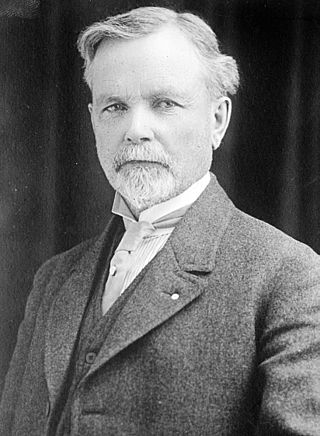
Peter Norbeck was an American politician from South Dakota. After serving two terms as the ninth Governor of South Dakota, Norbeck was elected to three consecutive terms as a United States Senator. Norbeck was the first native-born Governor of South Dakota to serve in office, and the first native-born U.S. Senator from South Dakota.. He is best remembered as "Mount Rushmore's great political patron", for promoting the construction of the giant sculpture at Mount Rushmore and securing federal funding for it.
Frank Morris Byrne was an American businessman and politician who served as the eighth Governor of South Dakota.
KRRZ is a classic hits radio station in Minot, North Dakota, owned by iHeartMedia through licensee iHM Licenses, LLC. KRRZ also airs Minnesota Vikings football games and The Rush Limbaugh Show.
Zell is an unincorporated community in Faulk County, South Dakota, United States, astride U.S. Route 212. It was once a stop on the old Chicago and North Western Railway.
The 1932 United States Senate election in South Dakota took place on November 8, 1932. Incumbent Republican Senator Peter Norbeck ran for re-election to a third term. After easily turning back a challenge from former State Senator Harry F. Brownell in the Republican primary, Norbeck faced attorney Ulysses Simpson Grant Cherry, the Democratic nominee, in the general election. Owing in part to Franklin D. Roosevelt's landslide victory in South Dakota, the race was much closer than it was in 1926, but Norbeck still defeated Cherry by a decisive margin to win his third, and final, term. Norbeck died in office on December 20, 1936, triggering a special election in 1938.
Yukon is a census-designated place located in South Huntingdon Township, Westmoreland County in the state of Pennsylvania, United States. The community is located near Interstate 70, north of the village of Wyano. As of the 2010 census the population was 677 residents.
Burkmere is an unincorporated community in Faulk County, in the U.S. state of South Dakota.
Miranda is an unincorporated community in Faulk County, in the U.S. state of South Dakota.
Beebe is an unincorporated community in Edmunds County, in the U.S. state of South Dakota. Other than a small manufactury, there are no businesses or services at Beebe and only three houses.
Greenway is an unincorporated community in McPherson County, in the U.S. state of South Dakota.
Loyalton is an unincorporated community in Edmunds County, in the U.S. state of South Dakota. Other than a couple of farms, there are no businesses or services located there, and less than half a dozen homes.
Powell is an unincorporated community in Edmunds County, in the U.S. state of South Dakota.
The 1916 South Dakota gubernatorial election was held on November 7, 1916. Incumbent Republican Governor Frank M. Byrne declined to seek re-election to a third term. Lieutenant Governor Peter Norbeck won the Republican primary to succeed him, and in the general election faced State Representative Orville V. Rinehart. Norbeck won his first term as Governor in a landslide over Rinehart.
Brentwood Colony is a Hutterite colony and census-designated place (CDP) in Faulk County, South Dakota, United States. The population was 116 at the 2020 census. It was first listed as a CDP prior to the 2020 census.
Thunderbird Colony is a Hutterite colony and census-designated place (CDP) in Faulk County, South Dakota, United States. The population was 7 at the 2020 census. It was first listed as a CDP prior to the 2020 census.
References
- ↑ U.S. Geological Survey Geographic Names Information System: Norbeck, South Dakota
- ↑ "Faulk County". Jim Forte Postal History. Retrieved February 2, 2015.
- ↑ Federal Writers' Project (1940). South Dakota place-names, v.1-3. University of South Dakota. p. 52.
Municipalities and communities of Faulk County, South Dakota, United States | ||
|---|---|---|
| City |  | |
| Towns | ||
| CDPs | ||
| Unincorporated communities | ||
45°11′03″N99°12′45″W / 45.18417°N 99.21250°W
| | This South Dakota state location article is a stub. You can help Wikipedia by expanding it. |