Hampshire County is a county in the U.S. state of West Virginia. As of the 2010 census, the population was 23,964. Its county seat is Romney, West Virginia's oldest town (1762). The county was created by the Virginia General Assembly in 1754, from parts of Frederick and Augusta Counties (Virginia) and is the state's oldest county. The county lies in both West Virginia's Eastern Panhandle and Potomac Highlands regions.

The South Branch Potomac River has its headwaters in northwestern Highland County, Virginia near Hightown along the eastern edge of the Allegheny Front. After a river distance of 139 miles (224 km), the mouth of the South Branch lies east of Green Spring in Hampshire County, West Virginia where it meets the North Branch Potomac River to form the Potomac.

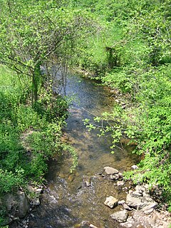
The Cacapon River, located in the Appalachian Mountains of West Virginia's Eastern Panhandle region, is an 81.0-mile-long (130.4 km) river known for its fishing, boating, wildlife, and scenery. As part of the Potomac River watershed, it is an American Heritage River.

Delray is an unincorporated community in Hampshire County in the U.S. state of West Virginia. Delray is located in the North River Valley along Delray Road between Sedan and Rio. According to the 2000 census, the Delray community has a population of 151.
Rio is an unincorporated community in southern Hampshire County in the U.S. state of West Virginia. Rio is located just north of the Hardy County line at the crossroads of Augusta-Ford Hill Road and Delray Road in the North River Valley. According to the 2000 census, the Rio community has a population of 154.
Hanging Rock is an unincorporated community in Hampshire County in the U.S. state of West Virginia. Hanging Rock is named for the "Hanging Rock" outcrop that hangs over the Northwestern Turnpike. It should not be confused with the plural "Hanging Rocks" over the South Branch Potomac River north of Romney at Wapocomo. Originally, the community of Hanging Rock sprang up in the Henderson Hollow gap of North River Mountain. While only a few buildings of the old hamlet remain, today's Hanging Rock is situated at the intersection of North River Road and Delray Road where the North River flows under U.S. Route 50 towards the Cacapon.
Frenchburg is an unincorporated community in Hampshire County in the U.S. state of West Virginia. Frenchburg is located along the Northwestern Turnpike where the Little Cacapon River is formed by the confluence of the North and South forks of the Little Cacapon east of Shanks. Frenchburg is also the location of the southern terminus of Little Cacapon River Road on U.S. Route 50. Frenchburg is primarily known for the events that took place there during the American Civil War.

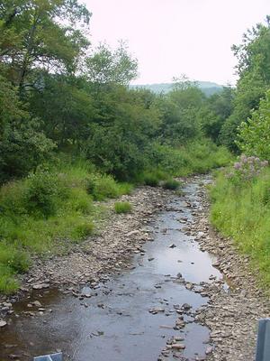
The Little Cacapon River is a 25.1-mile-long (40.4 km) free-flowing tributary of the Potomac River in the center of Hampshire County, West Virginia. Via the Potomac River, its waters are part of the Chesapeake Bay watershed, leading to the Atlantic Ocean. The Little Cacapon enters the Potomac at an elevation of 499 feet (152 m) near the community of Little Cacapon. For the majority of its course the Little Cacapon is a shallow non-navigable stream. It has been historically referred to as both Little Cacapehon and Little Capecaphon. The name is pronounced kə-KAY-pən or KAY-pən.
West Virginia Route 127 is an east–west state highway located in northeast West Virginia. The western terminus is at West Virginia Route 29 near Forks of Cacapon in Hampshire County. The eastern terminus is at the Virginia state line west of U.S. Route 522 and east of Good, where WV 127 continues eastward as State Route 127.
West Virginia Route 29 is a north–south state highway located in the Eastern Panhandle of West Virginia. The southern terminus of the route is at West Virginia Route 55 and West Virginia Route 259 in Baker, Hardy County. The northern terminus is at West Virginia Route 9 three miles (5 km) south of Paw Paw in Hampshire County.
Dillons Run is a 12.9-mile-long (20.8 km) tributary stream of the Cacapon River, belonging to the Potomac River and Chesapeake Bay watersheds. The stream is located in Hampshire County in the U.S. state of West Virginia's Eastern Panhandle.

Edwards Run is a 7.9-mile-long (12.7 km) tributary stream of the Cacapon River, belonging to the Potomac River and Chesapeake Bay watersheds. The stream is located in Hampshire County in the U.S. state of West Virginia's Eastern Panhandle. Edwards Run is named for Joseph Edwards and his family, whose plantation encompassed most of the stream's course. George Washington surveyed his property in the late 1740s. It is a major source of various species of elodea.

Mill Creek is a 14.0-mile-long (22.5 km) tributary stream of the South Branch Potomac River, belonging to the Potomac River and Chesapeake Bay watersheds. The stream is located in Hampshire County in West Virginia's Eastern Panhandle. Mill Creek flows into the South Branch west of Romney Bridge near Vanderlip along the Northwestern Turnpike.
Mill Branch is a 9.1-mile-long (14.6 km) tributary stream of the Cacapon River, belonging to the Potomac River and Chesapeake Bay watersheds. The stream is located in eastern Hampshire County in West Virginia's Eastern Panhandle.

U.S. Route 50 in West Virginia runs from the border with Ohio to Virginia, passing briefly through Garrett County, Maryland, and following the Northwestern Turnpike. Prior to the U.S. Highway System it was West Virginia Route 1 and in the 1930s, the road was not finished in Maryland. Today the section of US 50 from Clarksburg to Parkersburg on the Ohio River is part of Corridor D of the Appalachian Development Highway System.
North River Mountain is a mountain ridge that runs southwest to northeast in Hampshire County, West Virginia, United States. Named for the North River that parallels its western flanks for its entire length, North River Mountain reaches its highest elevation of 2,149 feet (655 m) near the community of Delray. North River Mountain extends from Staack's Gap at Rio to the Hiett Run gap at North River Mills. Geologically, Ice Mountain is the same mountain ridge, with the Hiett Run gap acting as the physical divide.
The Lost River is a 31.1-mile-long (50.1 km) river in the Appalachian Mountains of Hardy County in West Virginia's Eastern Panhandle region. The Lost River is geologically the same river as the Cacapon River: It flows into an underground channel northeast of McCauley along West Virginia Route 259 at "the Sinks" and reappears near Wardensville as the Cacapon. The source of the Lost River lies south of Mathias near the West Virginia/Virginia border. Along with the Cacapon and North rivers, the Lost River serves as one of the three main segments of the Cacapon River and its watershed.