Related Research Articles

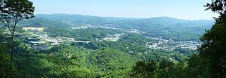
Boone is a town in and the county seat of Watauga County, North Carolina, United States. Located in the Blue Ridge Mountains of western North Carolina, Boone is the home of Appalachian State University and the headquarters for the disaster and medical relief organization Samaritan's Purse. The population was 19,092 at the 2020 census.

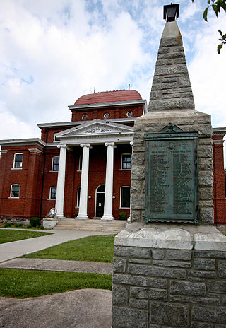
Watauga County is a county located in the U.S. state of North Carolina. As of the 2020 census, the population was 54,086. Its county seat and largest town is Boone. The county is in an exceptionally mountainous region. It is the home of Appalachian State University, which has approximately 20,023 students as of August 20, 2020. Watauga County comprises the Boone, NC Micropolitan Statistical Area.
Ashe County is a county located in the United States state of North Carolina. As of the 2020 census, the population was 26,577. Its county seat is Jefferson.

Elizabethton is a city in, and the county seat of Carter County, Tennessee, United States. Elizabethton is the historical site of the first independent American government located west of both the Eastern Continental Divide and the original Thirteen Colonies.

The Blue Ridge Parkway is a National Parkway and All-American Road in the United States, noted for its scenic beauty. The parkway, which is America's longest linear park, runs for 469 miles (755 km) through 29 Virginia and North Carolina counties, linking Shenandoah National Park to Great Smoky Mountains National Park. It runs mostly along the spine of the Blue Ridge, a major mountain chain that is part of the Appalachian Mountains. Its southern terminus is at U.S. Route 441 (US 441) on the boundary between Great Smoky Mountains National Park and the Qualla Boundary of the Eastern Band of Cherokee Indians in North Carolina, from which it travels north to Shenandoah National Park in Virginia. The roadway continues through Shenandoah as Skyline Drive, a similar scenic road which is managed by a different National Park Service unit. Both Skyline Drive and the Virginia portion of the Blue Ridge Parkway are part of Virginia State Route 48 (SR 48), though this designation is not signed.

Mount Jefferson State Natural Area is a 1,188-acre (4.81 km2) North Carolina state park in Ashe County, North Carolina in the United States. Located near Jefferson, North Carolina, it includes the peak of Mount Jefferson, named for Thomas Jefferson and his father Peter, who owned land nearby and surveyed the North Carolina-Virginia border in 1749. In 1974, Mount Jefferson State Natural Area was designated as a National Natural Landmark by the National Park Service.

The Holston River is a 136-mile (219 km) river that flows from Kingsport, Tennessee, to Knoxville, Tennessee. Along with its three major forks, it comprises a major river system that drains much of northeastern Tennessee, southwestern Virginia, and northwestern North Carolina. The Holston's confluence with the French Broad River at Knoxville marks the beginning of the Tennessee River.

The Cherokee National Forest is a United States National Forest located in the U.S. states of Tennessee and North Carolina that was created on June 14, 1920. The forest is maintained and managed by the United States Forest Service. It encompasses an estimated area of 655,598 acres (2,653.11 km2).

The Watauga River is a large stream of western North Carolina and East Tennessee. It is 78.5 miles (126.3 km) long with its headwaters in Linville Gap to the South Fork Holston River at Boone Lake.

Grandfather Mountain is a mountain, a non-profit attraction, and a North Carolina state park near Linville, North Carolina. At 5,946 feet, it is the highest peak on the eastern escarpment of the Blue Ridge Mountains, one of the major chains of the Appalachian Mountains. The Blue Ridge Parkway passes by the south side of the mountain and also passes over the nearby Grandmother Gap. It is located at the meeting point of Avery, Caldwell, and Watauga counties.

The Watauga Democrat is a newspaper published in Boone, North Carolina, one day a week on Wednesday and updated daily on its website at www.wataugademocrat.com. The Watauga Democrat was first published in 1888 to share news about the local Democrat Party, and today chronicles general local news in Watauga County.

Western North Carolina is the region of North Carolina which includes the Appalachian Mountains; it is often known geographically as the state's Mountain Region. It contains the highest mountains in the Eastern United States, with 125 peaks rising to over 5,000 feet in elevation. Mount Mitchell at 6,684 feet, is the highest peak of the Appalachian Mountains and mainland eastern North America. The population of the region, as measured by the 2010 U.S. Census, is 1,473,241, which is approximately 15% of North Carolina's total population.
The Appalachian National Scenic Trail spans 14 U.S. states over its roughly 2,200 miles (3,500 km): Georgia, North Carolina, Tennessee, Virginia, West Virginia, Maryland, Pennsylvania, New Jersey, New York, Connecticut, Massachusetts, Vermont, New Hampshire, and Maine. The southern end is at Springer Mountain, Georgia, and it follows the ridgeline of the Appalachian Mountains, crossing many of its highest peaks and running almost continuously through wilderness before reaching the northern end at Mount Katahdin, Maine.

Elk Knob State Park is a 4,423-acre (17.90 km2) North Carolina state park in Watauga County, North Carolina, in the United States. Opened in 2003, it is one of North Carolina's newest state parks. Elk Knob State Park was established to preserve the natural state of Elk Knob, the third highest peak in Watauga County. The park is open for year-round recreation and is currently undergoing an expansion of facilities to provide greater recreational opportunities to visitors. Elk Knob State Park is on Meat Camp Road, 5.5 miles (8.9 km) from North Carolina Highway 194, 9.5 miles (15.3 km) north of Boone, in the Blue Ridge Mountains.

Todd is an unincorporated community straddling the county lines of Watauga and Ashe counties in northwestern North Carolina, United States on the South Fork of the New River. It lies at an elevation of 2,992 feet. The population was 2,141 at the 2010 United States Census. The ZIP Code for Todd is 28684.

North Carolina Highway 88 (NC 88) is a 41.3-mile-long (66.5 km) primary state highway in the U.S. state of North Carolina. Primarily in the High Country, it runs from the Tennessee state line near Trade east to NC 18 in Laurel Springs.
Howard Knob is a mountain in the North Carolina High Country, located in the town of Boone. According to the US Geological Survey, the mountain's proper name is Howard Knob, but it is known to locals and tourists as Howard's Knob. Howard Knob and the surrounding area are part of the Appalachian Mountain Range. The mountain has an elevation of 4,396 feet (1,340 m) above sea level, and rises nearly 1,000 feet (300 m) above the town of Boone and the campus of Appalachian State University.

The 1st North Carolina Cavalry Regiment, initially formed as 9th Regiment, North Carolina State Troops, was a cavalry regiment from North Carolina that served in the Confederate States Army during the American Civil War. Raised in 1861 it served all over the Eastern Theater until it surrendered with the Army of Northern Virginia in 1865.
References
- 1 2 3 "Session Law 2019-74". Raleigh, North Carolina: General Assembly of North Carolina. July 1, 2019. Retrieved July 27, 2019.
- 1 2 3 "Northern Peaks Trail Master Plan" (PDF). Destination by Design. 2017. Retrieved July 27, 2019.
- ↑ "High Country Regional Trail Plan" (PDF). High Country Council of Government. October 2008. Retrieved July 27, 2019.
- ↑ "The Boone Area Outdoor Recreation Plan" (PDF). Watauga County Tourism Development Authority. Spring 2011. Retrieved July 27, 2019.
- ↑ Matt Candeias (2020). "Sustainable Recreation & Plant Conservation". In Defense of Plants Podcast. Retrieved November 30, 2020.