La Plant is a census-designated place (CDP) in Dewey County, South Dakota, United States. The population was 167 at the 2020 census. It is within the Cheyenne River Indian Reservation.
Chester is an unincorporated community and census-designated place (CDP) in Lake County, South Dakota, United States. The population was 257 as of the 2020 census. Chester has been assigned the ZIP code of 57016.
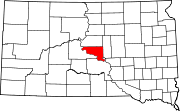
Winfred is an unincorporated community and census-designated place (CDP) in Lake County, South Dakota, United States, approximately 12 miles (19 km) west of Madison. The population was 38 as of the 2020 census.
Shindler is an unincorporated community and census-designated place (CDP) in Lincoln County, South Dakota, United States. The population was 607 at the 2020 census.
Lake Poinsett is a census-designated place (CDP) in Hamlin and Brookings counties in South Dakota, United States. The population was 501 at the 2020 census.
Crocker is an unincorporated community and census-designated place (CDP) in Clark County, South Dakota, United States. The population was 19 at the 2020 census.
Hutterville Colony is a Hutterite colony and census-designated place (CDP) in Brown County, South Dakota, United States. It was first listed as a CDP prior to the 2020 census. The CDP had a population of 95 at the 2020 census.
Prairiewood Village is an unincorporated community and census-designated place (CDP) in Brown County, South Dakota, United States. It was first listed as a CDP prior to the 2020 census. The CDP had a population of 303 at the 2020 census.
Swift Bird is a census-designated place (CDP) on the Cheyenne River Indian Reservation in Dewey County, South Dakota, United States. It was first listed as a CDP prior to the 2020 census. The population of the CDP was 117 at the 2020 census.
Blumengard Colony is a Hutterite colony and census-designated place (CDP) in Faulk County, South Dakota, United States. The population was 0 at the 2020 census. It was first listed as a CDP prior to the 2020 census.
Thunderbird Colony is a Hutterite colony and census-designated place (CDP) in Faulk County, South Dakota, United States. The population was 7 at the 2020 census. It was first listed as a CDP prior to the 2020 census.
Old Elm Spring Colony is a Hutterite colony and census-designated place (CDP) in Hutchinson County, South Dakota, United States. The population was 114 at the 2020 census. It was first listed as a CDP prior to the 2020 census.
Rustic Acres Colony is a Hutterite colony and census-designated place (CDP) in Lake County, South Dakota, United States. The population was 132 at the 2020 census. It was first listed as a CDP prior to the 2020 census.
Boulder Canyon is an unincorporated area and census-designated place (CDP) in Lawrence County, South Dakota, United States. The population was 561 at the 2020 census. It was first listed as a CDP prior to the 2020 census.
Long Lake Colony is a census-designated place (CDP) and Hutterite colony in McPherson County, South Dakota, United States. It was first listed as a CDP prior to the 2020 census. The population of the CDP was 8 at the 2020 census.
Wonderland Homes is an unincorporated, developed "neighborhood" community in Meade County, South Dakota, United States, consisting of numerous homes in subdivisional layout and several small businesses. Its origins are unknown, as is its relationship to other places or real estate development businesses called "Wonderland Homes". It is in the southwest part of Meade county, on the eastern edge of the Black Hills. It is bordered to the southwest by the town of Summerset and to the north by the town of Piedmont, to which towns it is sometimes connected as might be a subdivision. Exit 48 on Interstate 90 is 0.5 miles (1 km) to the west; I-90 leads northwest 17 miles (27 km) to Sturgis, the county seat, and southeast 11 miles (18 km) to Rapid City.
Clark Colony is a census-designated place (CDP) and Hutterite colony in Spink County, South Dakota, United States. It was first listed as a CDP prior to the 2020 census. The population of the CDP was 92 at the 2020 census.
Glendale Colony is a census-designated place (CDP) and Hutterite colony in Spink County, South Dakota, United States. It was first listed as a CDP prior to the 2020 census. The population of the CDP was 176 at the 2020 census.
Hillside Colony is a census-designated place (CDP) and Hutterite colony in Spink County, South Dakota, United States. It was first listed as a CDP prior to the 2020 census. The population of the CDP was 123 at the 2020 census.
Sicangu is an unincorporated community and census-designated place (CDP) in Todd County, South Dakota, United States, within the Rosebud Indian Reservation. It was first listed as a CDP prior to the 2020 census. The population of the CDP was 276 at the 2020 census.